1 February A trail angel took me to the Glenrock trailhead on the other side of the Rakaia River, where I officially resumed the TA, and began the climb on a grassy bulldozed track to Turtons Saddle, initially following Glenrock Stream but then leaving it. It was very muggy and I was immediately soaked in sweat. From above the Rakaia appeared to sit in a vast basin. The landscape on the saddle was a treeless expanse of pale yellow grass, exposed dirt and rocky slopes and almost other worldly. I’m seeing tiny lizards for the first time. I’m done with beech forest and now I’m in typical Canterbury terrain. I descended, the toilet belonging to the next hut clearly visible all the way although the hut only came into view at the last minute. I continued down to Turtons Stream and followed it to Comyns Hut which was in a grassy valley, an older corrugated iron hut (also built in 1957) but renovated inside. The hillsides were all yellow grass, alpine daisies with sharp leaves and the prickly matagouri bush (but without the pale green lichen draped over it further north). It was a quiet day on the trail: 3 northbound hikers and nobody else. It’s nice that I’m seeing more nobos now. Rain came very soon after I reached the hut. It was a wet and windy night. 16 kms
2 February I left when the rain stopped, for a 7 kilometre stretch of river crossing and recrossing which I had not been looking forward to. I had to go up the North Branch Ashburton River and then Round Hill Creek. Soon it started raining again. The first river was very winding with a sheer bluff on every bend so I was doing nothing other than crossing it repeatedly in order to move forward. (I stopped counting after 6 in order to concentrate on what I was doing but people counted 51 - 58 crossings.)

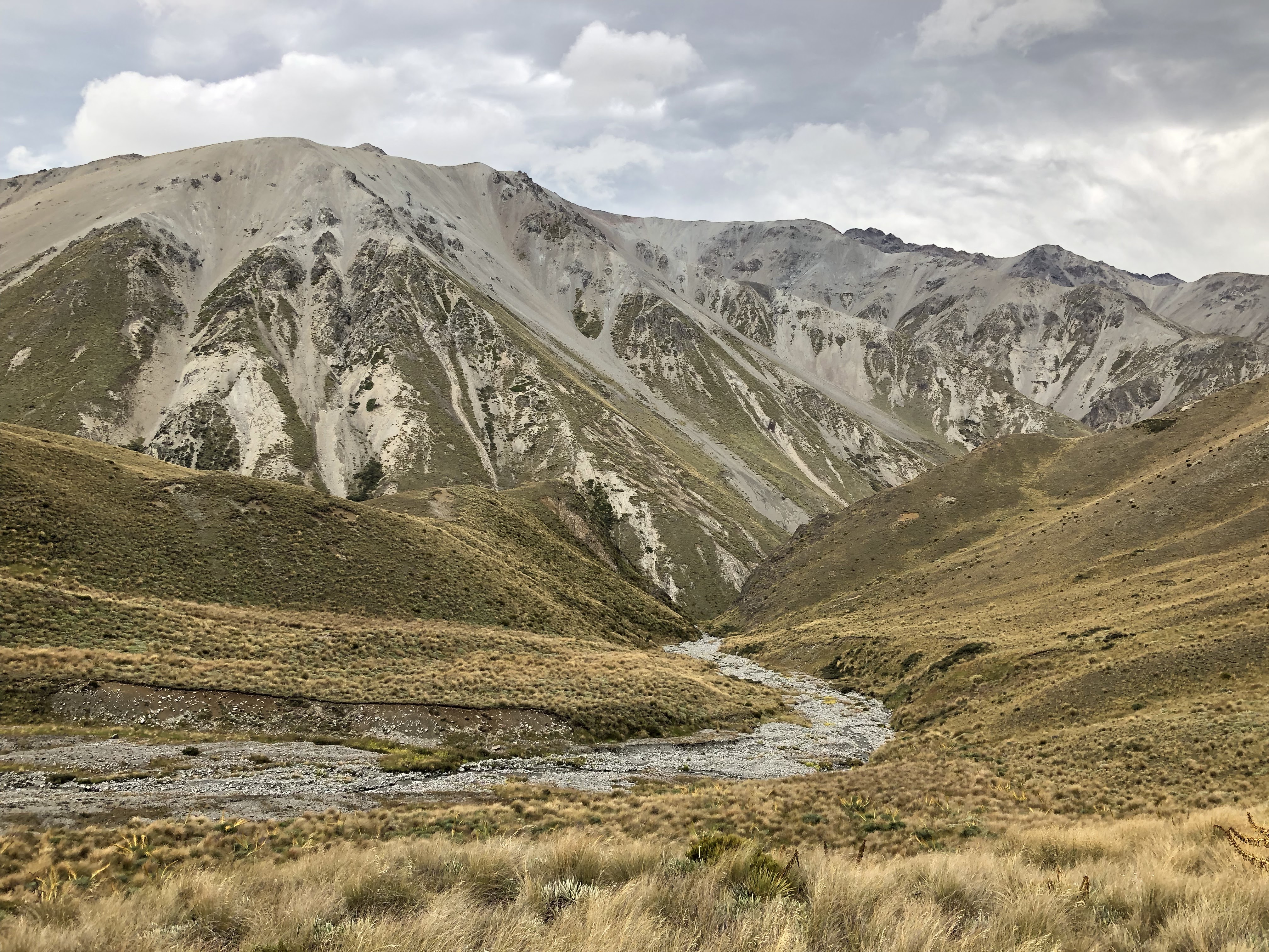
Sometimes it looked as though there was a path above the bluffs but these proved to be impossible to walk so I resolved to stay at river level. It would have been much more pleasant without the rain making the rocks wet and slippery. Mostly the water was shin to knee deep but once crotch deep. There would be rapids and deeper pools. Sometimes I just walked along the very edge of the river (in the water) to avoid crossing. Further up were longer straight parts along the creek and shingle. After 3 hours of this the rain stopped just as it was time to head away from the wet rocks for Clent Hills Saddle. It remained a grey day but no more rain. There was a path of sorts through tussock and Spaniard (giant speargrass), which sometimes went over a tiny stream with no warning so there would be an unexpected hole in the ground. Beyond the saddle (1480 m) I had 3 huge scree slopes to traverse and then a long descent interrupted by another saddle. I had a wonderful view of mountains around the Swin River North Branch; it’s quite a bleak area with yellow and brown treeless hills/mountains and lots of scree slopes.
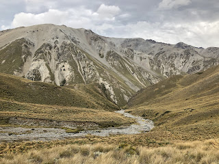
The only other vegetation is matagouri. The track was slow but I finally reached the Swin River with views of higher mountains to the west and several lakes.
I had a fast 5 kms with a strong tailwind on a jeep track to Manuka Hut and I managed to keep my feet dry with the last river crossing of the day. Nice company. In the evening there was a rainbow over the mountains opposite the hut. The wind howled around the hut all night. 23 kms
Day 100: 3 February I walked across the river plains and popped over a ridge to reach Emily Lake with ducks and swans. The sky was clearing but the mountains to the west were in cloud. I walked some dirt road and when I was resting in the shade a passing driver gave me 2 cans of soft drink. I crossed the milky looking Ashburton River South Branch on a bridge and turned onto a large grassy plateau dotted with hills. Masses of alpine daisies with their sharp leaves. There were convenient granite rocks for sitting. The wind was gusting strongly and was very unpleasant although not a headwind until later on. The views of rugged mountains in the west improved. I came to a point overlooking Lake Clearwater, bright blue, and a first glimpse of the Rangitata River which is the other river that shouldn’t be crossed on foot. I was on the lookout for somewhere out of the wind to camp but it was a challenge; I found a slightly sheltered place by a stream below Mt Guy with white gentians on my doorstep. There was no shade anywhere. I had a lot of trouble lighting my stove and once it was lit I was worried about starting a grass fire because the flames blew around so much. Then the wind died completely after sunset. 23 kms

4 February The sandflies were back! I had breakfast before the wind started up again and continued across the plateau. I had a good view of the mountains around Mt Cook but not yet Mt Cook. I came quite close to Clearwater Lake. The trail followed Potts River (has carved a little gorge) and I looked down on the Rangitata, which is 4 kilometres wide, and knew I wouldn’t dream of crossing it.
Even the Potts was wide and braided when I crossed it. I reached the road bridge which marks the official break in the TA. I had booked a shuttle but it didn’t turn up so I hitchhiked into Geraldine (another easy one, but the stress about the shuttle spoilt my afternoon). I met several hiker friends from the Richmond Ranges at the campground and we ate burgers together and I contributed the beer. 10 kms
5 February Rest day in Geraldine.
6 February I took the shuttle to Bush Stream on the other side of the Rangitata. The Rangitata was in flood, flowing fast and coloured a pale brown. I had been worried about the walk along Bush Stream because of the many crossings and recent rain; I was intending to do the bad weather forest route but the others persuaded me to do the stream. I was glad of this because it turned out to be a lovely day’s walking and the crossings (about 15) were not bad in dry weather and when I knew others were around. We stayed by the stream for as long as possible to avoid nasty climbs.

The stream was in a gorge of sorts and after a couple of hours the trail climbed high for a wonderful view of the gorge. I could also still see the Rangitata. Then we had a descent on scree followed by an even longer climb away from the stream. This climb was punctuated by a hut for lunch. The trail continued to a saddle at 1500 metres. There was a view of tussock and scree covered mountainsides in all directions. The trail went over a series of tussock hillsides and was a cut single track but I kept losing it. There were also some scree slopes to traverse and little streams to cross. I came back down to Bush Stream and Stone Hut but I arrived late and it was full so I slept on the floor. 20 kms
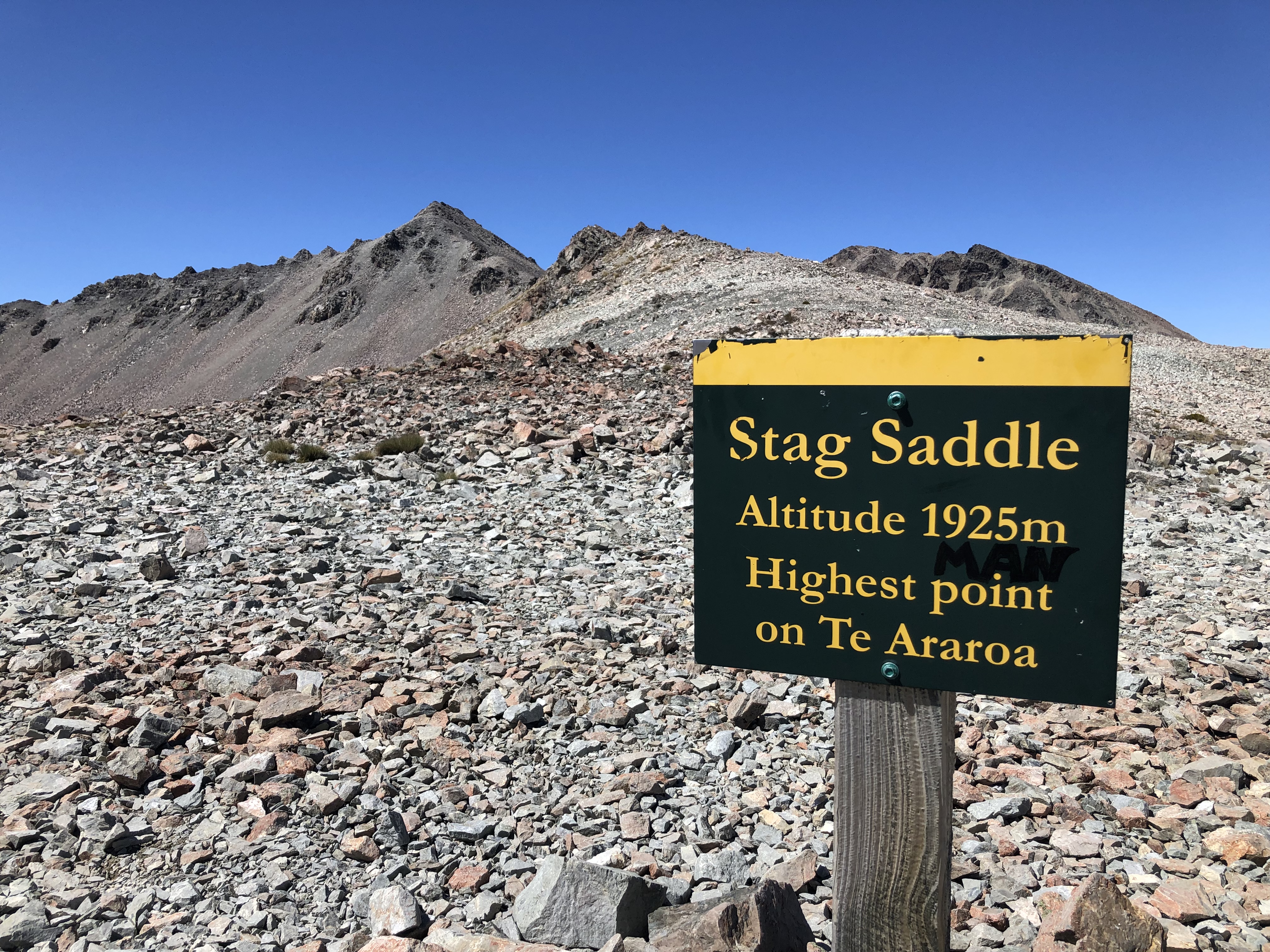
7 February Straight out from the hut was the first of the final 5 crossings of Bush Stream. The water was freezing. The trail was alongside the stream and was easier to follow. Only problem is that sometimes I mistake the Spaniard flower for a marker post! I chatted to a guy who is even more of a purist than I am: doing the TA to the metre on the official map. When I got to Royal Hut half way mark on SI) I thought I was done with river crossings and I wrung out my socks. But there was another set of streams that got me wet feet. The trail had been climbing gradually and now the climb to Stag Saddle began to get serious. I couldn’t see the saddle and the climb took longer than expected, especially since I went completely the wrong way and summited a separate knoll before reaching the saddle. The saddle (1925 m and highest point of the TA) was a sea of scree and windy.
From there I crossed slopes of big rock chips and then traversed scree slopes. Suddenly I went around a corner to start on a long descending ridge and the wind got significantly stronger; it was insane, and when I stopped to put on my jacket this was a huge ordeal as I didn’t want to lose anything. The walk down the ridge, despite the wind, was one of the highlights of the TA: I had views of the mountains around Mt Cook (Mt Cook’s summit was in a cloud), distant ranges, the Rangitata with its large number of braids, the tussock and scree Camp Stream valley, and above all the startlingly turquoise Lake Tekapo.

I came down towards Camp Stream and after losing the trail again for a while I got to a hut. This was a tiny hut and already over-full so I had my very overdue lunch and went on. I crossed the Coal River where people were already camping, and ascended steeply onto a tussocky plateau. I decided to camp by a stream near the ski area and when I arrived I was most surprised to see about 8 tents there, mostly people I knew. So I joined them. 28 kms
8 February Coldest morning so far. I put on a lot of clothes and headed along the plateau, still with good views of the mountains and lake. The ground was totally covered with minuscule plants. When I was into sunshine I was instantly warm. I came off the plateau to Boundary Stream and was finally able to have the coffee that it was previously too windy to make. After that I had a long 14 kilometre slog along a gravel road; it was beside the lake and I could see mountains but the road had no shade and too many cars. The section ended with a little path by the lake (which was fully raging because of the wind), an unnecessary detour to the famous stone church, across the control gates, and I rushed to the nearest cafe. I stayed at the YHA hostel with a stunning view of the lake. The bed was really comfortable. 30 kms
9 February I started out on my monster day: very early on in my TA I had decided I would try to walk from Tekapo to Twizel in a day and now I had to do it. Most TA walkers do this stretch by bike (or skip it) and I didn’t see another walker but I was passed by plenty of bikes - unsurprising as this is a bike trail. I listened to several podcasts and some NZ radio. The route was first alongside the Tekapo Canal and in the distance I had a cloud free view of Mt Cook with a massive amount of snow. I made a few short stops and had a longer break at the salmon farm, which was closed but some staff let me get hot water and use a couch to get out of the sun. The trail descended to Lake Pukaki, even more turquoise than Lake Tekapo if that’s possible, and I walked along the lake edge (lots of shingle beaches) for hours.

I had a perfect view of Mt Cook across the lake, while cloud began to hang around the lower peaks. I was lucky with the temperature, warm but not baking. When I turned inland I had a few kilometres of pine forest and then I was onto the 8 kms of Pukaki Flats; this was a vast open area of grass and the wind was roaring across so it was horrible and there was nothing to look at and also no possibility of stopping for a rest. Result: I got to Twizel an hour earlier than expected (11 1/2 hours after leaving Tekapo) and I was able to get some food at the supermarket. I walked over to the motel that had backpacker rooms and as I was looking around for the office I saw Tom standing outside a room; he called out to me that they (Tom, Femke, Elise, Roy and Sonja) had a spare bed! Perfect. 55 kms
10 February Rest day in Twizel with Chris and Tom.
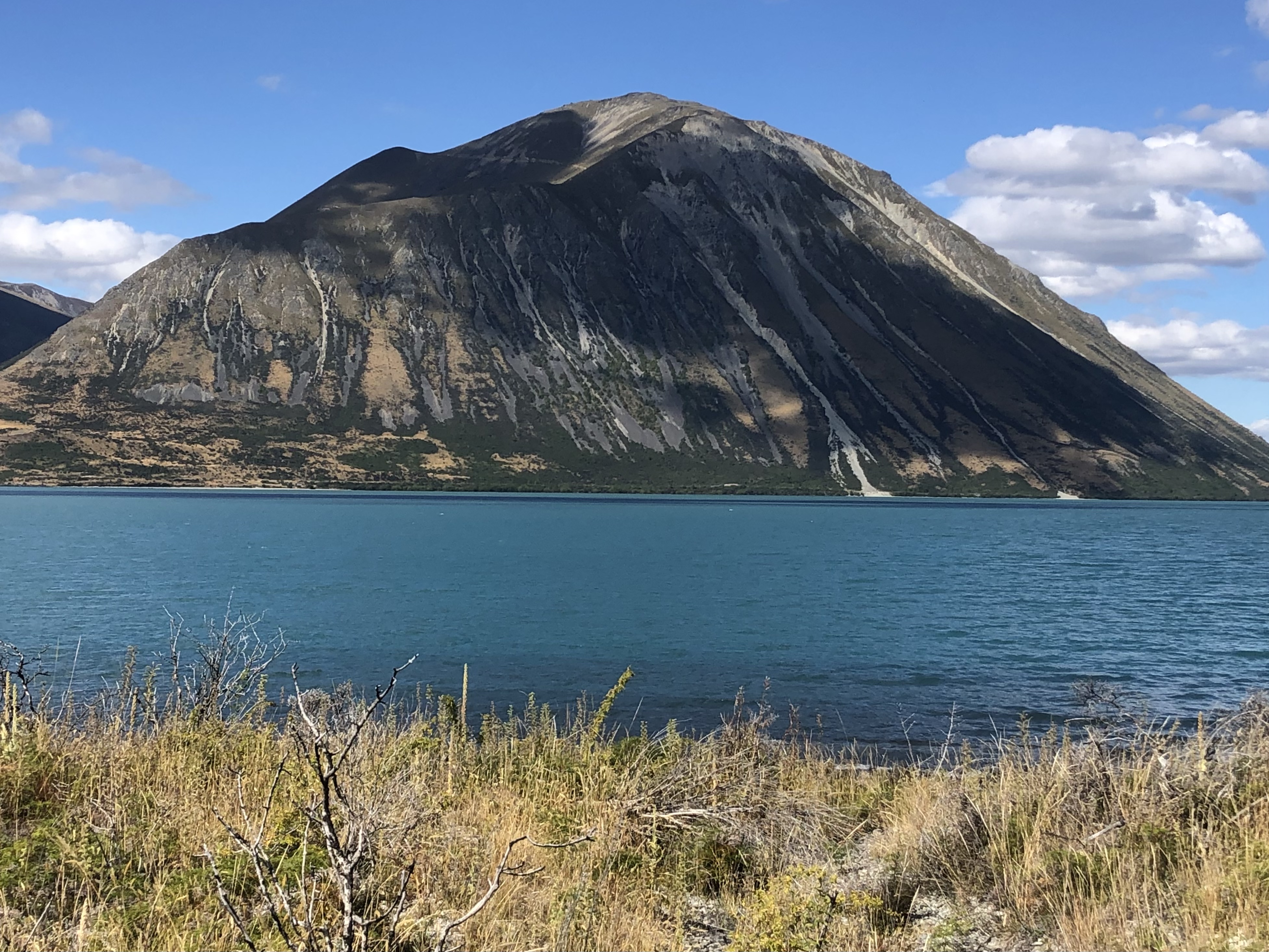
11 February I walked out of Twizel and turned off the highway at the Ruataniwha Dam then went along the side of Lake Ruataniwha. It was cloudy and I thought it might rain. After the lake I followed the Ohau River; the terrain was like a wasteland until I got to Lake Ohau and back onto the Alps to Ocean bike trail. I was then walking at the lake edge, the sky cleared and I could admire huge conical Ben Ohau across the lake.
Then a rocky range speckled with snow came into view and Mt Cook was somewhere in the background. Unfortunately I felt tired and hungry and it got very hot. I walked to a campsite as quickly as possible, which wasn’t fast at all, so I could rest and make a coffee (in the cool of the toilet block).
I felt better after that and continued by the lake to the turnoff for the Ahuriri valley, liking the feeling of the late afternoon sun. The trail started climbing and went through wooded patches, some of which had been burnt. I was aiming for a picnic table to camp beside and when I reached it I was surprised to find Sonja and another hiker there. We were effectively on a ledge above the lake with a superb view. 37 kms
12 February This was supposed to be a difficult day: the TA notes implied the need for expertise at orienteering to follow the route, followed by the widest unbridged river crossing of the trail. For these reasons I had decided to make my own detour and avoid this section, only relenting at the last minute. All turned out well and the day’s walk was a highlight of the TA.
The trail climbed to a saddle, initially in beech forest and I had breakfast in the forest beside Freehold Creek then continued onto open tussock. The low cloud was lifting and by the time I reached the saddle the sky was blue. I had to follow the Ahuriri River East Branch which was tiny here, crossing a few times and contouring huge scree slopes. The path was obvious and well marked and the river snaked along glistening in the sunshine. It was slow going with a lot of swampy stuff. The trail climbed and then contoured above the river as it went through a golden valley.

I had a loose arrangement to meet Chris and Tom at the big Ahuriri River crossing but I feared I wouldn’t make it in time. Where the valley widened the going got quicker and I was at the river only 40 minutes later than our agreement. The river appeared much less threatening than I had anticipated. I packed up my gear for the crossing and suddenly heard Tom on the far bank calling out. They both crossed the river to collect me and then the 3 of us crossed together and it was a delightful experience. Chris talked the whole way so I had no time to worry. The water was up to my waist but the current wasn’t too strong and I didn’t slip on the underwater rocks. We walked back to their car (passing a marker showing nobo hikers had done 500 kms), had a cup of tea and they left. I walked up a farm track
and just after a stream I saw a place to camp that had shade from wild rose bushes (and lots of sheep and cows nearby). I mused that this has become my way of life now. 26 kms
Day 110: 13 February Bluebird day. I am in Otago now. I walked along Avon Burn and crossed multiple times.
The vegetation was matagouri and wild roses. At one stage I walked by a high fence and saw a bull with big horns on the other side. Then I got onto a 4WD track to climb towards Martha Saddle and the stream below went into a narrow gorge. The golden mountains were beautiful looking back where I had been. I had a break at a hut and continued to climb, now among bigger mountains with vast scree slopes. This was a particularly long ascent. It was windy at the saddle (1680 m) with a superb view down the Timaru River valley ahead and I could clearly see the scree path I was about to sidle down.


The descent was steep but enjoyable and soon I was traversing tussock alongside the river. It was very hot and my back was sore so it was good that the stunning scenery and a light tailwind could keep me going. I was relieved to reach Top Timaru Hut and go inside for a while, and I prepared my couscous for dinner in case I couldn’t cook by my tent. The trail went into beech forest, undulating above the river, and I loved it even though the path was sketchy by SI standards; it was cool and I could always see/hear the water. As soon as I emerged onto a grassy river bank I set up my tent. The sandflies were bad. 25 kms
14 February Straight from my camp spot I had my first of 14 river crossings - cold. The trail went back into the forest (yay, no more wasps) and I bumbled along slowly, some hairy slips to contour and more steep rooty descents. It was a junior version of the Richmond Ranges. I had some time on the shingle/rocky river bank, going into the forest to get past cliff faces and avoid gorges. Around midday the real climbing began and it was steep. I had some openings in the forest with views of mountains across the river, mainly tree covered, and later on some more distant peaks. I stopped at Stodys Hut for lunch, above the tree line.
My afternoon was hiker heaven. I had a good trail that climbed to a ridge and then went over the tussock hills with views west to the velvety green mountains across the Timaru River, south to a series of rugged ranges with Mt Aspiring prominent, and east over Canterbury hills. When I reached the summit of Breast Hill (1578 m) I was astonished by the sight of Lake Hawea, much larger than I expected, deep blue, and I could see a bit of Lake Wanaka beyond.
The descent was on a single track through scrub along a cliff edge with continuing views over the lake, until I came to Pakituhi Hut in the middle of a tussock slope; it was full but I was able to sleep on a bench by the window. I could look up and see the stars. 23 kms
15 February My day began with a steep descent (950 m in 5 kms) down the cliff like edges of the hills between the hut and the lake, to Lake Hawea. It was tricky in places with rocks but overall ok. The second part was along the lake and once in the town I made a dash for the store/cafe. I had my first ice cream in ages. I walked along the Hawea River bike path to Albert Town; it was a gravel trail just above the river, which had rapids and rocky islands. When I got to Albert Town I had a milkshake and chips but I didn’t think much of the dusty featureless place. I continued to Wanaka; I made a deviation from the TA and went via Mt Iron, a prominent low rocky mountain, on a quiet trail. Wanaka was crazy busy. I went along the lake to the nearest campground. I wasn’t sure I had the energy to go out for dinner but I managed to get to a bar (overlooking the lake and its huge surrounding mountains) for a burger. 31 kms
16 February I had a slow morning doing shopping and having breakfast at a cafe (separately Elise and Sonja stopped by for a chat) and then Viv arrived with Tim and we had a lovely time. I bought sushi to have for a picnic lunch and walked out of town along the lake, passing the famous tree that grows in the lake (with ducks protecting it).
There were many little beaches and I stopped for a swim; the water was just right. Then I ate my sushi overlooking the lake. The water was so serene. The trail undulated a lot and it was hot work, the landscape was dry with matagouri, bracken ferns and manuka. As soon as I got to the campground I had another swim. 16 kms
17 February I walked a dirt road to the start of the Motatapu track, renowned for its steep ups and downs. Things began easily in farmland and then I went into beech forest following Fern Burn with typical slow progress. Nice and cool though, on another hot day. I came out onto a grassy ridge higher above the stream with craggy mountains around. Lots of lizards. After a while I could see the hut not far away but to reach it I had to descend steeply to cross the stream and climb back up; a perfect place for a long suspension bridge, maybe one day… After a break at the hut I continued to go up, much of it steep, with several dips down to cross Fern Burn.

I could see the path snaking over the hills in both directions. I reached Jack Halls Saddle (1275 m); the high points are getting lower though I still have to earn them. The mountains have much exposed granite and they look more folded, all crowded together, with no spaces in between. The walking was mainly on a knife edge ridge and no wind. I descended steeply to a side stream off Highland Creek then climbed again only to descend to the main creek. I was at Highland Creek Hut before
3 pm for a nice short day. I enjoyed a long nap. 17 kms
18 February It wasn’t possible to see a way out of the mountains around the hut! The trail climbed steeply (of course) to a high point with close up views of the mountains with bare granite outcrops, and distant peaks with snow, then descended along a spur. Below I was surprised to see a road. Next a steep descent into forest and across a stream where I would have made coffee were it not for the sandflies. Another steep climb to an equally high point from where I had a view east into the wide Motatapu River valley. The trail has been a properly formed path but when it was over tussock there were still unexpected holes and I managed to fall into one of these; I pulled myself up with difficulty by hanging onto handfuls of grass. Then a descent to a rare piece of farmland (I heard sheep) and a start to the climb to Roses Saddle. Roses Hut was a little way along the Motatapu River and I was more than ready for a break after a lot of hard work. After lunch I continued the climb to the saddle (1270 m) and was pleased to have a breeze (and I ignored the black cloud above me). This was another steep stretch and I was rewarded with a view into the Arrow River valley, again completely enclosed by mountains.

My knees felt completely shot after all this steep terrain. I descended along a ridge and reached the river. From here I was supposed to walk in the river, which was cooling, fun and not as daunting as it sounded. The river had lots of rapids and whirlpools but the current wasn’t as strong as it looked and the bottom wasn’t slippery. I swapped from side to side, walked near the edge on little beaches and sometimes in knee deep water to avoid bluffs. Increasingly there were worn tracks in the grass beside the river, but there was too much matagouri for my liking. After 4 kms of this I came to a 4WD track which still kept crossing the river but was easier walking, and I arrived at Macetown, a former gold mining settlement with only one remaining building, where I camped. 23 kms
19 February Swarms of sandflies in the morning. I had to cross the river about a dozen times leaving my feet numb, then I commenced the final big climb of the range. Suitably named Big Hill with a saddle just below the summit. This is one of the last serious climbs of the TA. There wasn’t much view there but as I descended I could see Lake Hayes and Arrowtown. The descent was gradual, bits of forest and along a ledge cut into the hillside. The lower part was busy with day walkers and Arrowtown was absolutely heaving with people. I had a wonderful evening at the pub with Viv. 14 kms
20 February I had some road walking to Lake Hayes and then followed the lakeside trail. I went through a new development and through urban parks to cross the Shotover River on the original bridge.
I ended up in Frankton where I bought new shoes, trying not to feel awkward about the ones I was wearing, and had a coffee to celebrate. Then I continued down the hill towards Queenstown and went onto the walkway along Lake Wakatipu. It was suddenly hot and I was anxious to reach my motel. Later I walked to the Queenstown wharf where the TA has another of its forced interruptions because the lake is in the way. I thought the town centre was a mess with lots of streets dug up and dirty looking cafes - disappointing. 23 kms
South Island so far: 1030 kms
Total to date: 2717 kms


No comments:
Post a Comment