I decided to do the Te Araroa trail because I had read a book about someone who did it in the very early days - it opened in 2011. It isn’t a continuous trail as such but a route, going the length of New Zealand, starting at Cape Reinga at the top of the North Island and finishing at Bluff at the bottom of the South Island. About 3000 kilometres of walking plus several bodies of water that must be crossed with transport.
There were many things about the TA that I wasn’t aware of when I started out, first and foremost that 99% of people I would meet on the trail do not walk the whole way, instead hitchhiking or using buses on the bits they consider boring. I was determined to walk the whole route and even to avoid the Whanganui River canoeing section, which would require a detour off the official trail. I intended to stay in a motel once a week but I soon realised it wasn’t possible. Probably the biggest surprise of all was the number of estuaries, creeks and rivers I would have to wade.
Day 1: 27 October Three of us were dropped off at Cape Reinga just before 11, and we walked down to the lighthouse and signpost which is the start of the trail (there is no official northern terminus sign). 
We took photos then descended to Te Werahi beach. I went on ahead and was soon at the rocks I was worried about crossing at high tide, but they were no problem despite it being close to high tide. Then I passed Cape Maria van Diemen at the end of a sandy spit. The coastline was dark rocks. At the end of the beach I had my first creek crossing just before the huge Te Paki dunes, the water came up to my shorts, and then I crossed peach coloured dunes and came to a grassy trail, lots of flax. Back at the ocean on Twilight beach I stopped for lunch and went on to Twilight campsite, nice and grassy and a little windy. When I got my tent out of my bag I couldn’t see the pegs and I was alarmed that I may have left them at home but when I unrolled the tent they were there and the NZ customs had moved them when inspecting the tent. Time to see if my purple metho works; last time I carried purple metho (Carnarvon Gorge) it wouldn’t burn but luckily this time it burned. I was alone when I arrived but we were eventually 18 walkers. Nearly everyone had brand new gear. The beach was lined by pohutukawas. Little yellowhammers came into the picnic shelter and there was a swallows nest in the rafters. I went for a paddle, not too cold, and saw a lovely sunset over the water. 13 kms

We took photos then descended to Te Werahi beach. I went on ahead and was soon at the rocks I was worried about crossing at high tide, but they were no problem despite it being close to high tide. Then I passed Cape Maria van Diemen at the end of a sandy spit. The coastline was dark rocks. At the end of the beach I had my first creek crossing just before the huge Te Paki dunes, the water came up to my shorts, and then I crossed peach coloured dunes and came to a grassy trail, lots of flax. Back at the ocean on Twilight beach I stopped for lunch and went on to Twilight campsite, nice and grassy and a little windy. When I got my tent out of my bag I couldn’t see the pegs and I was alarmed that I may have left them at home but when I unrolled the tent they were there and the NZ customs had moved them when inspecting the tent. Time to see if my purple metho works; last time I carried purple metho (Carnarvon Gorge) it wouldn’t burn but luckily this time it burned. I was alone when I arrived but we were eventually 18 walkers. Nearly everyone had brand new gear. The beach was lined by pohutukawas. Little yellowhammers came into the picnic shelter and there was a swallows nest in the rafters. I went for a paddle, not too cold, and saw a lovely sunset over the water. 13 kms

28 October I walked for an hour on an undulating trail behind the dunes, crossing headlands with great views, then came onto 90 Mile Beach. It stretched straight ahead to the horizon and I walked along the firm sand for almost 6 hours, with a welcome tailwind. The beach was very wide, backed by grassy dunes, many creek crossings, lots of gulls, oystercatchers and dotterels.
I could see other hikers way in the distance in front and behind. I walked for a few kms with a Kiwi couple. Sometimes it was hot, but often cloudy. There was a large rock well offshore with a hole through it, the hole only visible from the north. This is the sole offshore sight of the entire beach. I made two short stops for snacks. The campsite was virtually on the beach, idyllic but totally unprotected from the wind. 28 kms

I could see other hikers way in the distance in front and behind. I walked for a few kms with a Kiwi couple. Sometimes it was hot, but often cloudy. There was a large rock well offshore with a hole through it, the hole only visible from the north. This is the sole offshore sight of the entire beach. I made two short stops for snacks. The campsite was virtually on the beach, idyllic but totally unprotected from the wind. 28 kms
29 October All day on the beach. Same dunes, and bits of forest behind. Nice tailwind. Some of the dunes are more pointy than others. Fewer birds, more vehicles. My back gets sore quickly and my shoulders ache. I walked with Marius from Romania. The main excitement of the day was a police 4WD stopping to ask if I’d seen a man with a moko and no bags who’s gone missing. (I’ve only seen people with bags.) He gave me an update on the rain situation which we’re all worried about. The campsite was off the beach but with a sea view, and we all crammed into the little bit of grass without prickles. 30 kms
30 October it was a grey day and within an hour it was raining. The tide was far out. I wore my shorts until they were soaked and then changed to rain pants; this was a test for my new rain jacket and it did well. The beach and sand looked grey but the walking was ok. There was nothing out to sea and nothing on the sand apart from a few shells and the occasional dead fish. After 17 kms I came off the beach briefly to a cluster of houses, and a rubbish bin, and the rain stopped. The water was turquoise again and I could see hills in the distance, a few pine trees. In a while I could see the houses of Ahipara on the hillside. I plodded on, my back sore. Outside Ahipara I put my shorts back on and they were soon dry. I walked up to the caravan park to camp, pretty happy to have finished the featureless beach. Nobody else from my starting cohort of 18 turned up. 31 kms
31 October I walked through Ahipara and then continued along the road to Kaitaia. It was really muggy. The road had a small shoulder and was quite busy but drivers were courteous. My only issue was finding somewhere secluded, and not a private garden, to wee. It was dairy country, very green, and the road undulated which was nice after the past days. I took the back road into town and dumped my pack at the motel before 11. 16 kms
1 November I set out early from the motel because I was worried about the first section on SH1. There was minimal shoulder and some fast traffic but not as bad as I expected and I did the 5 kms in under an hour.
I then had a long gravel road walk which I did with Kat (a Kiwi from my cohort) and George (Czech) in a nice rural setting. It was a sunny day. We came to the detour that bypasses the kauri forest and joined a slightly hilly track which crossed several creeks with views over the green valley. The vegetation, palms, punga, manuka, rimu, pines was very lush. We stopped for lunch beside a creek, sitting on grass full of buttercups. Then we descended to the small settlement of Broadwood to camp at the picnic area, but first we went to the shop for ice creams; none of us had known there was going to be a large shop there. There was a loquat tree where we camped and we were able to reach a few fruit. 32 kms
2 November I set out alone for a long road walk. There was minimal shoulder and none whatsoever on most of the blind bends. It was green rolling countryside. 
Once I stopped but a nasty dog headed towards me so I went on, reaching the Mangamuka River where it was lined by mangroves. Further on the river was prettier and I came into the small settlement of Mangamuka. I had coffee and carrot cake.

Once I stopped but a nasty dog headed towards me so I went on, reaching the Mangamuka River where it was lined by mangroves. Further on the river was prettier and I came into the small settlement of Mangamuka. I had coffee and carrot cake.
After lunch I walked a gravel road towards Omahuta forest with Kat and we climbed through it to a summit and on down to Apple Dam campsite, a tiny grassy nook. Kat, George and I were nicely settled there when just before 7 a group of 10 hikers turned up and set up their tents completely swamping the campsite; more were coming. This was a bad scenario so I packed up my stuff and went back up the access track to camp alone beside the trail. Sadly this is exactly what I was afraid of when I heard the TA was so busy. 34 kms
3 November I set out with George just as it started to rain. We were planning to have breakfast at a campsite not far away. George was following the route on his phone and I didn’t want to get mine out in the rain. Bad mistake. Long after we should have reached the campsite I pulled out my phone and realised we were not on the main trail but on a much longer alternative bypass route as George’s map only showed that option. By then it was not worth backtracking to the main trail. After talking to the others later it seems George did me a favour, the track was horrendous.
The route was logging roads, rather a slog climbing onto a ridge and staying up there with numerous steep undulations. There were some views over the forest but everything was misty or in cloud. The rain was on and off all day. I had a break at the top of a waterfall and again by a small waterhole. The final bit was in dense forest with tall kauri trees.
After that I was on a gravel road through farmland on yet another road detour (not a mistake this time). I was looking for somewhere to camp and everywhere appealing was flooded or fenced off. I ended up in a quarry with a pile of old tyres and a pile of broken wooden pallets, but well drained ground. The rain stopped for dinner and bedtime. 38 kms
4 November I left my quiet quarry with sun and more roads (a glimpse of the massive Kerikeri inlet) until turning onto the Mangakaretu Walkway. At last a trail! At first it was over wet grass following fences but then went into a small pine forest before more boggy grass and descending to Waimokaikai Creek, down a hillside filled with punga. 
The creek was lovely, little falls and mossy rocks so I stopped to make coffee and sit among the punga. Too soon I returned to a fence and farmland. The creek widened and joined a bigger one and then the Kerikeri River. The path passed beautiful big pines and impressive Rainbow Falls with a large pool, then a grove of kauri and I was on the outskirts of Kerikeri.
I walked into town and to the first decent cafe I saw. I was so hungry I had to go and have chips after my lunch. Great chips. 24 kms

The creek was lovely, little falls and mossy rocks so I stopped to make coffee and sit among the punga. Too soon I returned to a fence and farmland. The creek widened and joined a bigger one and then the Kerikeri River. The path passed beautiful big pines and impressive Rainbow Falls with a large pool, then a grove of kauri and I was on the outskirts of Kerikeri.

I walked into town and to the first decent cafe I saw. I was so hungry I had to go and have chips after my lunch. Great chips. 24 kms
Day 10: 5 November I walked out of Kerikeri towards the inlet. Everything was quiet. I crossed the inlet at a tiny mangrove lined creek. Then I went through pine forest: many denuded hillsides and some native regeneration, very undulating. I emerged at a golf course and sea views, then passed the Waitangi Treaty memorial stone and grounds. I crossed a bridge towards Paihia and ate a pre-lunch snack by the beach. Paihia was really busy. Now I can say I have walked across New Zealand.
I took the ferry across to Russell, one of the many options for crossing the bay. In Russell I replaced my cap with a new one that didn’t impinge on my views and set out for the Russell-Okiato Walkway. I had difficulty following it at first and always returned to a busy road, until I came closer to the water and crossed a large expanse of mangroves on a boardwalk. Unfortunately I had to backtrack to the campground. I went into the bush at the back to look for kiwis (unsuccessfully) but I heard them at night. 26 kms
6 November Road walking again. First on a sealed road which wasn’t too busy and passed a lot of mangroves and gave a few views towards the ocean, then a great stretch on a really quiet gravel road through forest. Big climb and long descent back to the sealed road and farmland. I was already quite tired and the roads with no shoulder are stressful. I made a descent to another expanse of mangroves and came to an unfenced paddock by a creek; it looked a good camping spot so I went to the bach across the road to ask if I could camp and Tania and Taka there said I should camp on their lawn instead. (Then they offered me a bed in their house in Ruakaka when I get there!) A neighbour’s dog pestered me all evening and then slept next to my tent. 28 kms
7 November I had to get away from the dog! I had breakfast a kilometre down the road and walked alongside a creek then through a few settlements. After a descent I made the short detour to Te Mimiha beach; it was extremely windy and the surf was pounding on the shingle beach, and I had to share the experience with an obnoxious American hiker (the only obnoxious hiker of the entire trail).
Next came one of the better parts of the trail: a 4 km steep climb in forest on a narrow track to Helena Ridge. At the top was farmland with cows and clumps of pine trees. There was a distant view of the coastline beyond green hills. Very soon the trail returned into the forest and within minutes I came to a clearing with a picnic table, water tank and a sign saying walkers could camp; it was early for stopping but this looked nice so I stopped. I had good company there. 21 kms
8 November Rained all night and when I woke up I could see flooding was imminent so I packed in a hurry and left. The first bit along the ridge (no view) was over wet grass and windy then I walked on a forest road, which was nice enough with lush vegetation and no cars. I stopped after 7 kms to shelter under a shed roof and made coffee with water from a roof pipe overflow. Soon I joined a sealed road, the usual absence of a shoulder on tight bends, and the roadside drainage channels were gushing. The rain seemed to get less but always worsened again and the creeks were all dirty brown and raging. In many places the road had flooded and lower down there was a lot of flooding in the paddocks. The rain was especially nasty when the wind gusted. I barely stopped and I avoided the estuary walk in Whananaki as the area was obviously impassable. I was delighted to see the Whananaki shop although I had to walk around a new lake to reach the entrance. 
I sat on the porch for 1 1/2 hours and several locals chatted about the (unwanted) rain. Then I got a tiny cabin at the caravan park next door. The rain got much worse, 150 ml today. 23 kms

I sat on the porch for 1 1/2 hours and several locals chatted about the (unwanted) rain. Then I got a tiny cabin at the caravan park next door. The rain got much worse, 150 ml today. 23 kms
9 November Still and overcast. I walked the 400 metre long timber footbridge across the estuary and onto the Whananaki Walkway. It passed little coves and crossed hills with ocean/headland views. 
When I got to Sandy Bay a local woman said I should take the coast road; I felt I should follow the TA inland. Within minutes of heading inland I turned back for the coast and soon realised the coast route was far superior. I walked along Woolleys Beach and then went around the Matapouri headland with great coastal views (coves, islands, promontories), ending up walking on lovely Matapouri Beach. I stopped at the shop for coffee and toastie. Then I continued on the road to Tutukaka. At the general store the Swiss conspiracy theorist hiker had a big rant at me.

When I got to Sandy Bay a local woman said I should take the coast road; I felt I should follow the TA inland. Within minutes of heading inland I turned back for the coast and soon realised the coast route was far superior. I walked along Woolleys Beach and then went around the Matapouri headland with great coastal views (coves, islands, promontories), ending up walking on lovely Matapouri Beach. I stopped at the shop for coffee and toastie. Then I continued on the road to Tutukaka. At the general store the Swiss conspiracy theorist hiker had a big rant at me.
After an egg sandwich I walked to Ngunguru, passing a little lookout tower where I saw some tuis close up. The tide was way out so there were endless sand flats. I walked to the ferry crossing and then back to the shops for chips, and hitched back to Tutukaka. The campground was full of ducks and damp. 27 kms
Total so far 374 kms
10 November Rest day in Tutukaka chez Dom and Beckie.
11 November I stayed at Dom’s in the morning and the weather was disgusting. At 2.30 I was ferried across the Ngunguru River. It was suddenly hot. This was timed so I could cross the Horahora River 6 kms later close to low tide. In places the trail was very muddy and slippery. At the Horahora I had difficulty locating the place to start crossing until I realised the posts with markers were almost totally submerged. The mangroves at the edge should have been in sand at low tide but were in knee deep water. I could see crossing on foot wasn’t really possible and didn’t know what to do. Suddenly a tinnie was coming down the river; it stopped, turned and came to where I was sitting and someone asked if I wanted a ride across. What amazing good luck! They took me across and said I should follow the mangroves and then the fence. I waded knee deep through the mangroves and saw the track along the fence. Soon I was knee deep again when the flooded track became like a creek and it got deeper and deeper. I hung onto tree branches and wanted to hold onto the fence wire but it was electric. I finally had to cross the track/creek, only a few metres wide but the bottom just disappeared, and I was in to my waist, very alarming. I’ve never been so happy to join a sealed road.
Then I undulated along past grazing cows and sheep to Pataua North and crossed another river on a timber footbridge. I went to the campground and it was completely deserted but had a nice picnic area with an ocean view. 13 kms
12 November I woke up in fog but soon blue sky prevailed. Hot. In order to avoid another possible drowning in a flooded river I did a road walking detour on tar seal then gravel. I arrived at Ocean Beach to walk 7 km on the sand. It was near high tide and I had to paddle around some rocks then wade waist deep across a creek. I walked the whole beach without shoes, often cooling my feet in the waves. The beach was backed by low dunes and had some washed up logs. 
Separated by a headland at the far end was a little curve of beach that was busy. I climbed up the next headland on a grassy track with lovely views over the long beach and lots of islands, becoming steep, to a picnic table at a WW2 radar tower, where I had lunch. It was hot and still.

Separated by a headland at the far end was a little curve of beach that was busy. I climbed up the next headland on a grassy track with lovely views over the long beach and lots of islands, becoming steep, to a picnic table at a WW2 radar tower, where I had lunch. It was hot and still.
I thought I was at the top but I still had a long steep climb to Bream Head with a perilous drop to the water on one side and a view of the whole area, beaches, inland grass, rocky islands, on the other. I continued in rainforest, sometimes dripping and certainly muddy, with a bit of descent followed by major climbs. The climbing seemed endless but often I had nice coast views, and finally I got to the top of Mt Lion. The descent was quick and easy on hundreds of steps. A good test for my knees. I ended up by a cute sandy beach and crossed the grassy promontory to reach the calm bay waters protected by Bream Head. The rest of the day was on roads at the water’s edge and it rained lightly. I stopped outside the Manaia Club by Mt Manaia to charge my watch and I read how someone had camped there, so I went inside and the bar woman said of course I could camp on her lawn. How wonderful to get a pub meal! 33 kms
13 November I walked quickly along the waterfront walkway to Reotahi Bay from where I had to cross Whangarei Harbour by boat. After some messing around to get a ride, during which time I almost left my hiking poles where I had breakfast, I was taken across by Peter and Norma. At Marsden Point oil refinery (nobody could say TA isn’t varied) I initially went wrong and was put right by a guy at the customs point. Apparently I had set off an alarm. I walked many kms along the white sand beach with views across to Mt Lion, waves lapping gently but becoming bigger swell as I left the bay. In order to avoid crossing the Ruakaka River mouth I took a detour inland to cross the river on a bridge and had a long walk along the main road, on a footpath. I came to a shop where some friends were sitting and I had a goody goody gumdrops ice cream and bought Toffee Pops. Heaven knows why, but I ate them between Ruakaka and Waipu. The stretch of beach beyond Ruakaka was lovely, white sand, empty, turquoise water. Then more roads, this time to get past Waipu River mouth. The river was wide and brown. I had very late lunch in Waipu. The final push to Waipu Cove was a struggle and it was slightly off the trail, but the campground was very nice and many familiar tents. I had a little paddle on the beautiful beach, seeing the peaks I climbed yesterday in silhouette. 
I ate my fish and chips overlooking the beach. 34 kms

I ate my fish and chips overlooking the beach. 34 kms
14 November Back on the trail I had a long climb onto a range above the coast with great views of grassy hills behind the beach and logged hills inland. The road became gravel entering forest, lovely ferns, and then muddy (but not to Tasmanian standard). I had a chat with a man living up there (arrived from England in 1974 and a conspiracy theorist). It was a roller coaster with ocean views near the top, but the way down was a wider trail; a grader was coming through, and it looked like the area will be developed soon. From the bottom I had an immediate climb through farmland and at the top I had a chat with a farmer who offered me water. There were cows on the path. I saw a heron. Then I crossed paddocks, went through a small patch of forest (saw rosellas) and ended up on Mangawhai Cliffs trail, the highlight of the walk so far. In hot sunshine I walked above the scalloped coast, tiny beaches and rocks, at the top of grassy slopes with pohutukawa and flax.
I finished with a black sand beach and rock hopping to arrive at the white sand beach of Mangawhai Heads. It took ages to negotiate the route to the shops and I was very hungry and extremely hot. Then the last part walking to Mangawhai village was just main road and industrial, interrupted by mangroves at the estuary, then a quiet campground on the river bank, vast sandy/mangrove flats at low tide. 31 kms

I finished with a black sand beach and rock hopping to arrive at the white sand beach of Mangawhai Heads. It took ages to negotiate the route to the shops and I was very hungry and extremely hot. Then the last part walking to Mangawhai village was just main road and industrial, interrupted by mangroves at the estuary, then a quiet campground on the river bank, vast sandy/mangrove flats at low tide. 31 kms
Day 20: 15 November I’m finished with Northland and entering the Auckland region. I left on an unpleasantly busy gravel road and was glad to reach the beach. Pakiri beach was 14 kms in two parts separated by a headland. It was windswept and backed by dunes that were vertical on the beach side. The first part had some people fishing and lots of oystercatchers, dotterels and gulls and I walked in the shallows. The second part was totally deserted and had two creek crossings I was concerned about, especially as high tide was approaching. I waded the first up to my thighs, not a good omen for the next, bigger, creek. It was obvious that there is no beach left at high tide and even getting off the beach looked tricky where the dunes were like sheer cliffs. So I planned to leave the beach early and follow a road, crossing the creek in farmland where it was narrow. This increased the distance but should be safer. If I could find the road. Suddenly I saw a fairy penguin standing at the water’s edge. It wasn’t moving but it blinked.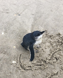
I stayed on the beach until I saw a break in the dunes and was surprised to find a tiny trail leading to pine trees, and then I could see a road on the other side of the creek. The creek was opaque and I couldn’t tell the depth. I decided to chance it and it was thigh deep but only five steps to get across. The road walk was fine, almost no cars and through a valley then over a hill. I glimpsed the creek estuary and there was no way I could have got across. I rejoined the trail in Pakiri.

I stayed on the beach until I saw a break in the dunes and was surprised to find a tiny trail leading to pine trees, and then I could see a road on the other side of the creek. The creek was opaque and I couldn’t tell the depth. I decided to chance it and it was thigh deep but only five steps to get across. The road walk was fine, almost no cars and through a valley then over a hill. I glimpsed the creek estuary and there was no way I could have got across. I rejoined the trail in Pakiri.
I had a big climb on grass following a fence to a ridge with a wonderful view over the coastline and hinterland then embarked on a very muddy rest of the day. The Mt Tamahunga trail went into rainforest full of ferns, palms, mossy tree trunks and vines and the mud was bad in many places. Lots of tree roots to negotiate. As I climbed I was completely closed in by the vegetation so I had no idea I was in a cloud until I was able to look out and saw nothing. The summit (432 m) was consequently uneventful, and not far on I passed the weather radar station for Auckland. The descent was also muddy and my feet were soaked. At the bottom I checked my sleeping options and there weren’t any, but as I started down the road I saw a house that I’d read was a trail angel so I went there and asked if I could camp; they were very welcoming and the lawn had a great view to the beach at Omaha. 36 kms
16 November Some gravel road then I returned to the forest for the track to the Dome. From an early opening I saw Rangitoto. It was lovely and peaceful in the forest with less mud than yesterday. The first section of trail descended to Waiwhiu Creek; I crossed it ankle deep then walked alongside as it gurgled away to a second crossing on submerged rocks. A brief steep climb on a grassy road and I went back into forest for the slow remainder of the climb. 
Every time I ascended I would have an equivalent descent so it took a long time to gain height. Near the summit was a small grove of kauri. There was a limited view of forest from the summit and a tricky descending scramble, followed by another climb, to a proper lookout. I was looking over Warkworth to the Mahurangi Harbour and (faintly) Rangitoto. The descent was fast on a gravel path.

Every time I ascended I would have an equivalent descent so it took a long time to gain height. Near the summit was a small grove of kauri. There was a limited view of forest from the summit and a tricky descending scramble, followed by another climb, to a proper lookout. I was looking over Warkworth to the Mahurangi Harbour and (faintly) Rangitoto. The descent was fast on a gravel path.
The rest of the day was mostly very peaceful gravel or grassy roads with views into Dome Valley. I passed a trail 500 kms marker, made from plant stalks (although I’ve done much more because of all the detours). I was tired but decided to go part way up Moir Hill to camp. Happily the forestry road went straight up instead of messing about and I found a spot to camp with only a little climbing for tomorrow. 31 kms
17 November The suggested campsites beyond mine all had beehives. I continued to the top and got a misty view towards the Hauraki Gulf; the Dome really looked like a dome from here. The trail went into a patch of bush and followed a grassy ridge. 
After I crossed the Puhoi River on a suspension bridge and entered forest to start the Puhoi Track I was disappointed as it wasn’t in sight or sound of the river, instead I heard logging and saw much devastation on the hillside. Before descending on a grassy slope I had a lovely view over Puhoi. I had a snack in Puhoi while it rained then set out on 6 kms of SH1. Not as bad as I expected as there were roadworks so part of the road was empty, and I had views over the winding river.

After I crossed the Puhoi River on a suspension bridge and entered forest to start the Puhoi Track I was disappointed as it wasn’t in sight or sound of the river, instead I heard logging and saw much devastation on the hillside. Before descending on a grassy slope I had a lovely view over Puhoi. I had a snack in Puhoi while it rained then set out on 6 kms of SH1. Not as bad as I expected as there were roadworks so part of the road was empty, and I had views over the winding river.

In Waiwera it was pouring; I had chips at a cafe and realised I was out of whack with the tides so I had to stay on the road. This road was less walker friendly. I got a glimpse of the shoreline and there would have been nowhere to walk below the cliffs. At Hatfields Beach I walked on the sand and continued on a footpath. Just before Orewa I had a view of the long straight beach and the whole Whangaparoa peninsula. 
I walked half way along Orewa beach until it poured again; I noticed Maccas across the road so I rushed in. I’m ashamed to say the food tasted good. I walked to the far end of Orewa in heavy rain. I had really felt like staying in a hotel, even before the rain started, so I took a bus to Devonport and checked in to the pub opposite the ferry. 28 kms

I walked half way along Orewa beach until it poured again; I noticed Maccas across the road so I rushed in. I’m ashamed to say the food tasted good. I walked to the far end of Orewa in heavy rain. I had really felt like staying in a hotel, even before the rain started, so I took a bus to Devonport and checked in to the pub opposite the ferry. 28 kms
18 November. Rather a mixed day. I returned to Orewa on 4 buses (amazingly I bumped into Dom and Beckie at one of the bus stops; I knew they were visiting Auckland) and walked a bike path alongside the wide mangrove filled estuary. Then some unattractive walking past a shopping mall and industrial suburbs before the long and busy road down to Stillwater. This was one of the worst roads yet for safety. It was raining from time to time. From Stillwater, a quiet place with mangroves, I started the Okura bush path, through boggy grass then palm forest. At Karapiro Bay it suddenly poured and I chatted with a day walker while sheltering under a tree - she checked her weather app and said the worst of the rain was over. This was a point where I couldn’t do the main trail because the Okura River estuary crossing could only be done at low tide, but I hoped to do the high tide riverside alternative. I walked Karapiro Beach (wild and windy) and I immediately saw that I couldn’t do the high tide route either as it involved walking on a rock platform that was partly submerged and extremely slippery. So I had to walk a detour inland of 14 kms first on a wide road with no traffic and then the fast moving East Coast Road. It rained and the rain got heavier and heavier; it was most unpleasant. The shoulder was flooding fast. Once I sheltered under a motorway bridge. Almost 3 hours after Karapiro Bay I reached Auckland. The sun came out. I saw my first shop (I hadn’t eaten for 9 hours). I descended towards Brown’s Bay with some sea and Rangitoto views and as I neared the beach it poured once again. At the beach I stopped and got the bus back to Devonport. I had dinner with Dom. 34 kms
19 November Rain was forecast but it didn’t come, also I had a low tide, so I had a nice walk down the northern beaches. Starting from Browns Bay I walked below amazing steep cliffs on sand, rocks and rock platforms. 
I had never been to this part of Auckland and I had no idea those cliffs existed. I went inland to cross Waiau inlet then walked the kilometre of Milford beach, more rocky stretches around headlands, then 2 kilometre Takapuna Beach (where I wanted to stop for coffee but the only beachfront cafe all morning was far too busy). The beaches were full of walkers on a Saturday morning. The next beaches Narrow Neck and Cheltenham were smaller, with my closest views of Rangitoto.
I walked around North Head for harbour/city views and came into Devonport along Duders Beach. Just in time for coffee and chips. I had dinner with Beckie’s family and Dom. 19 kms

I had never been to this part of Auckland and I had no idea those cliffs existed. I went inland to cross Waiau inlet then walked the kilometre of Milford beach, more rocky stretches around headlands, then 2 kilometre Takapuna Beach (where I wanted to stop for coffee but the only beachfront cafe all morning was far too busy). The beaches were full of walkers on a Saturday morning. The next beaches Narrow Neck and Cheltenham were smaller, with my closest views of Rangitoto.

I walked around North Head for harbour/city views and came into Devonport along Duders Beach. Just in time for coffee and chips. I had dinner with Beckie’s family and Dom. 19 kms
Total to date 630 kms
No comments:
Post a Comment