
After doing my Jagungal loop I decided to head for the coast and do the Light to Light walk near Eden in the far south, even though I knew the trail wasn't at its best after the fires last year. It was a long drive from the mountains so I was pleased to see that there were some good day walks along the coast on the way.
Feb 26 My first walk was the Bingie Dreaming Trail between Congo Beach
and Tuross Head. It was an overcast day but a pleasant temperature for walking. The trail was a mix of beach walking - hard on the outward journey because it was high tide and there was very little beach and no hard sand so I resorted to walking a fair bit on the dunes - and forest sections when I went inland to get around headlands. There were also grassy flats, complete with grazing kangaroos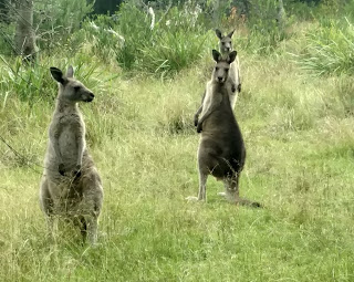

and several wide lagoons to go around, which came very close to the ocean at high tide. The forest was interestingly varied: patches of dense giant banksias, casuarinas, zamias, and ordinary schlerofyll. The beaches were long and mostly yellow sand.
When I got to Tuross Head it was coffee time and I asked someone where I could find a cafe; he wanted to send me miles away so after walking a while I asked someone else and then someone else, finally reaching a cafe 2 kms from the end of the trail. I hadn’t budgeted on this extra distance.
The sun was out for a while on the way back and the beach walking was good. All up 29.5 kms.
Feb 28 I walked the Kangarutha Trail in Bournda National Park from Kianinny Bay in Tathra to Turingal Head and return, 17.5 kms on a very hot day.
This was a completely different coastline with deeply indented rocky bays and lots of up and down. I crossed various pebbly, rocky and sandy coves and walked high above others. Some of the track was in melaleuca forest, very grey and dense.
I saw lots of dark coloured wallabies and a goanna but the highlight was noticing a wombat on the path ahead of me and watching it run off really fast. This seemed an unusual environment to stumble across a wombat.
The penultimate beach, Wallagoot Gap, was exactly as the name suggested, a tiny beach between high cliffs.

On the way back I detoured to Whites Bay with dramatic rocks.

March 2 My next hike was supposed to be the Light to Light Track but Ben Boyd National Park was closed for several days while they did aerial shooting of feral pests. So I had to cool my heels in Eden, and I decided to try the hike up Mt Imlay. The mountain dominates the skyline to the south of Eden. It's only a short 6 kms return walk but with a 600 m gain in elevation to the top at 886 m. The notice board at the trail start had warnings about the steepness and mentioned that people had got lost in the forest so I took my PLB.
This whole area was badly burnt in 2019 so I had low expectations. The long access road and the whole mountain featured charred tree trunks and some epicormic growth, although low ferns had proliferated and there were plenty of tiny gum saplings. There was nobody around.

The trail rose steeply in the burnt forest from the car park and soon entered overgrown young vegetation. It was extremely windy although I didn't feel the wind once I was among the trees. The mountain appeared as a big dome but I felt that I wasn't seeing the top yet. I first had to crest a subsidiary mountain then traverse across to Mt Imlay. Mostly the trail was a distinct dirt path with just a couple of rocky bits. There were remains of interpretive signs, which had substantially melted but at least showed where the trail went, and there was some pink flagging. I made a little cairn at one place where the track went over rocks. I had views towards the north, the coast and the coastal ranges, and these views weren't blocked by leaves on the trees.
The trail reached a rocky ridge and followed it as a more gradual climb, with the summit out of sight until I was right there. The last stretch featured lots of grass trees among the rocks. The views over Eden and Twofold Bay were good but hazy. 

Coming down I had no issues at all with following the trail.
March 3 Light to Light Track. As this is a point to point walk, and the shortest distance between the ends is the trail, I would have to do it both out and back, but with limited camping options, so I made a plan.
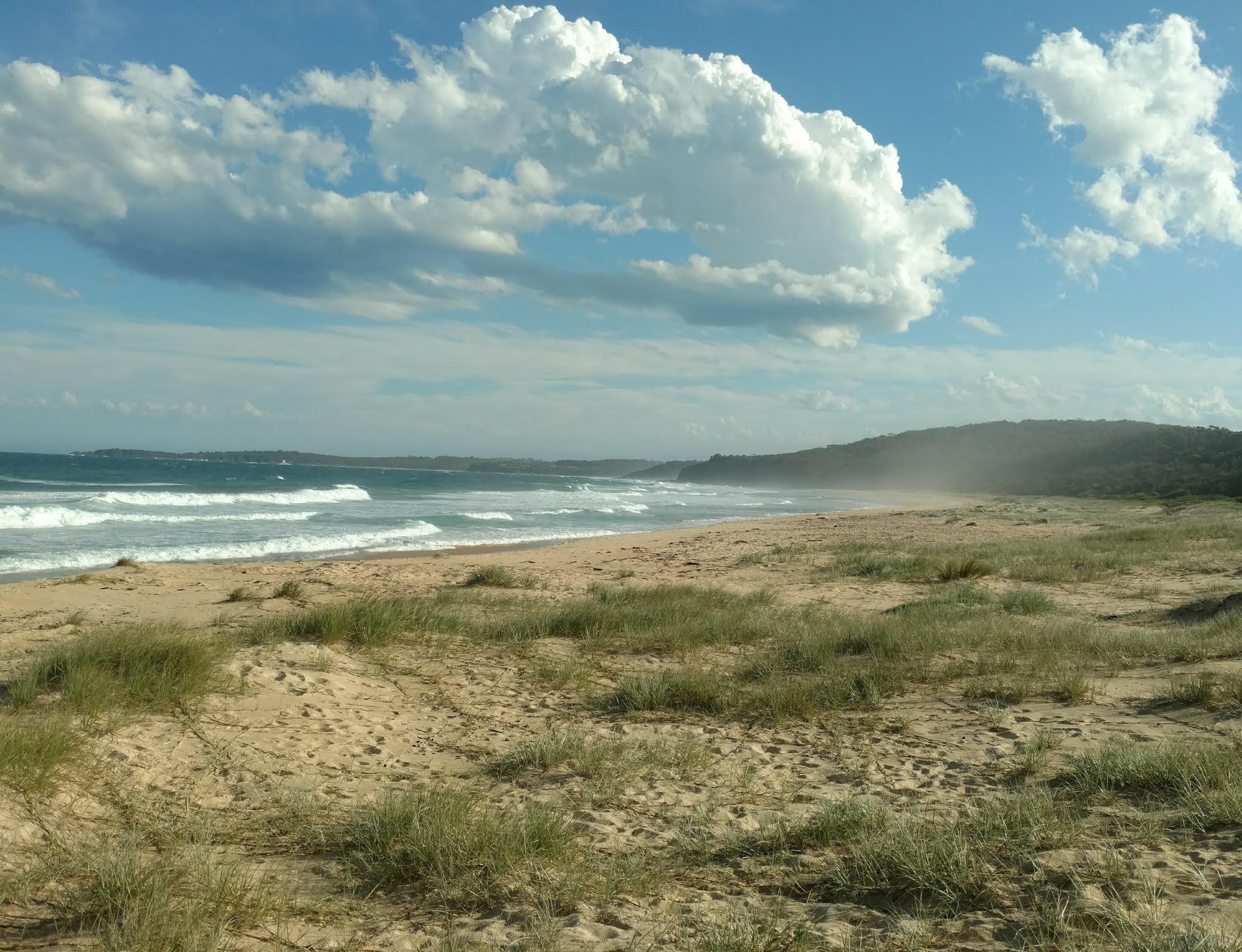
In the late afternoon I drove to Saltwater Creek campground close to the midpoint of the walk and parked. From there I headed north towards Boyd's Tower where the walk officially begins. Although the camp area itself was not much burnt the trail was straight away through burnt land. I walked 5 kms to Mowarry Point and camped just above the sandy beach in a setting that was totally idyllic (pictured at the top). The vegetation wasn't burnt and kangaroos came to visit.
March 4 It was going to be a hot cloudless day. I continued 8 kms to Boyd's Tower, leaving my pack hidden in the bushes at Mowarry. The tower is a simple stone structure that was intended to be a lighthouse but was not allowed to operate as one so was used as a lookout for whales when whaling was the big deal around Eden. The views towards Eden were very clear.

I turned south and walked in light forest, mostly burnt. There were impressive red rocks and cliffs and nice views back to the tower.

I crossed a few pebbly beaches and a short red rock shelf, then yellow grassland. The dark red, almost purple, rock is a distinctive feature of this coastline. Leather Jacket Bay was a nice spot, a deep sandy bay.

Mowarry Beach still looked beautiful with the sapphire water and red rocks and I sat under a tree for lunch, having retrieved my pack. From my vantage point I watched a goanna on the dunes about 100 metres away. I walked a long rock shelf and had some views of inlets down the coast but most of the scenery was, sadly, dead banksias and casuarinas. I could see Saltwater Creek beach in the distance and was happy to get there. As I descended to the beach a black snake wriggled off the track.
It seemed I had no option but to stay at this campground, having discussed the camping situation with hikers who had come from the other direction. The beach was long and the water looked inviting so I walked to the far end and had a short swim. I was surprised the water wasn't colder. There was a goanna skulking around my campsite and it gave my car a good hiss.
The wind came up like crazy in the night. I was using my Tarptent and it blew over repeatedly between 1am and 4am because the pegs wouldn't hold in the sandy ground. One time I couldn't find a peg until I saw it on the other side of the tent. I gave up trying to keep the tent upright and I wrapped it around me like a bivvy. Then I slept well. 22 kms
March 5 The southern half of the track was often away from the coast, although usually within sight of the ocean, and was more enjoyable for showing greater recovery from the fires. The first long stretch was through high yellow grasses with sparse (burnt) banksias that could be filtered out. 3 kms out of Saltwater Creek I had my first sight of the lighthouse at Green Cape, the end of the Light to Light, 14 kms away by trail. Among the grasses was a little coastal heath with wildflowers

and green forest in the distance. I crossed a pebbly beach at Hegarty Bay (where there was a tiny campsite closed due to danger of falling trees, and some trees looked very threatening) and a pretty creek with flowing water. After more grassland there was a long blocky rock platform

which I almost missed by having too much fun bashing through some melaleuca and not noticing a turn off the track. From the rock platform I had another clear sighting of the lighthouse.
The track went through mature forest with scribbly gums and other gums which was a real treat, then descended to Bittangabee Bay, a deep inlet with a small beach.

Moments after glimpsing the beach I looked at my feet just in time to see a fat snake slithering off the path. I left my pack at the campground and continued towards the Green Cape lighthouse.
The track went into a ferny gully and through casuarina forest. I saw a lyrebird scratching in the bushes. The trail stayed in light forest crossing a couple of stagnant creeks. For the final 4 kms the track was over open heath, views of the lighthouse in the distance, and more wildflowers. It was really windy. I was with some other walkers and when they all suddenly stopped I guessed correctly they had met a snake.
At the lighthouse the water below was really churning and I had to put on my rain jacket against the gale. I had a good view along the coast southward into Victoria but this was a bleak spot on such a windy day.

I turned back and returned to Bittangabee campground. On the way I saw the same lyrebird scratching about. This campground also had its resident goanna looking very much in charge. I had a pleasant time sitting on the rocks by the beach, well sheltered. The cliffs were very dramatic

24 kms
March 6 I set out early for returning 10 kms to Saltwater Creek. Bittangabee beach looked so lovely in the morning light.

Again I enjoyed the forest. From the long rock platform I could see crabs on another rock platform far below. At Hegarty I sat for a while, luckily no trees fell. When I got to Saltwater Creek (Saturday morning) it was like a different place, busy with cars parked everywhere. 61.2 kms altogether.
No comments:
Post a Comment