The South Downs Way running from Winchester to Eastbourne seemed to be the right distance for the time I had available on this quick trip to England. I knew the scenery wouldn't be dramatic but it would be different and I'd get plenty of chances to visit country pubs. My accommodation choices meant I would have to come off the official route most nights.
10 June In Winchester (Hampshire ) I went to check out the gothic cathedral: old tombs, austere naves, Norman part with frescoes, low tower. 
Walked around the Wolvesey castle ruins, crossed the Itchen River and left the town. Rain jacket on, rain jacket off, repeat. It remained muggy. I had a gentle climb between wheat fields, poppies here too, chatted to a couple of walkers. I entered the South Downs national park. Crested Cheesefoot Hill with expansive views of farmland then descended. I had to leave the SDW for my hotel so I detoured via Tichborne with a flint church (old style closed pews) that has been in use since 11th century,
followed by a coffee at the village pub.

Walked around the Wolvesey castle ruins, crossed the Itchen River and left the town. Rain jacket on, rain jacket off, repeat. It remained muggy. I had a gentle climb between wheat fields, poppies here too, chatted to a couple of walkers. I entered the South Downs national park. Crested Cheesefoot Hill with expansive views of farmland then descended. I had to leave the SDW for my hotel so I detoured via Tichborne with a flint church (old style closed pews) that has been in use since 11th century,

followed by a coffee at the village pub.

I went on across some fields (lots of poppies)
and into New Alresford on streets of red brick houses. The main street looked very English with quaint shops and pubs. Churchyard with hundreds of weathered headstones. It became sunny. Another nice pub for dinner. 19 kms

and into New Alresford on streets of red brick houses. The main street looked very English with quaint shops and pubs. Churchyard with hundreds of weathered headstones. It became sunny. Another nice pub for dinner. 19 kms
11 June I spent half the day getting back to the SDW, going along little roads and dirt tracks passing fields and in woods. In Hinton Ampner I looked inside the flint church and walked through the formal grounds of the red brick stately home. I rejoined the SDW near Beacon Hill (201 m, where the South Downs officially begin) with views south to the Solent and Isle of Wight across green fields separated by hedges and trees. 
Then a descent to Exton (nice views looking back uphill) where I went to the pub for coffee.

Then a descent to Exton (nice views looking back uphill) where I went to the pub for coffee.
I went along a trail by an old railway line and started the climb up grassy Old Winchester Hill, with an Iron Age fort and burial sites. I wasn't sure what I was looking for but after I came down a little on the far side I could see a line of mounds.
I stayed on the ridge with nice views of farmland as far as the coast
and then descended to a large farm. After a while I left the SDW again for my hotel in East Meon. This was a largish village in the valley. Appealing Norman church ranked in England's top 1000. 26 kms

I stayed on the ridge with nice views of farmland as far as the coast

and then descended to a large farm. After a while I left the SDW again for my hotel in East Meon. This was a largish village in the valley. Appealing Norman church ranked in England's top 1000. 26 kms

12 June I took some trails and a bit of road to Buriton as it drizzled, then it started pouring and I sheltered outside a closed pub until it cleared. I walked past a pond and pretty church and rejoined the SDW, climbed a trail to the ridge; at the top I immediately turned the wrong way and ended up fighting through nettles and blackberry to get back to the SDW. The trail went onto Harting Down, rolling grassy tops with views over South Harting and surrounding valley.
Then it poured again.

Then it poured again.
Afterwards I had a nice climb over Beacon Hill (240 m) with extensive views of green fields, hills, trees, and a few buildings. There was a stretch of forest and I saw Devils Jumps burial mounds. I walked along the ridge with a couple of walkers for a while and turned off to cross fields with sheep and lambs to Cocking. 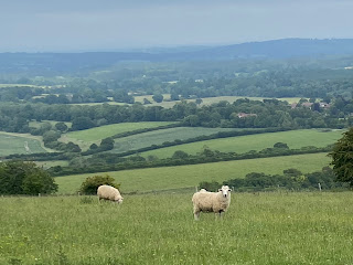
From there I had a road walk (punctuated by a tramp across a field) to my B & B. I sampled both the local pubs (two pubs for about ten houses). Now in East Sussex. 28 kms

From there I had a road walk (punctuated by a tramp across a field) to my B & B. I sampled both the local pubs (two pubs for about ten houses). Now in East Sussex. 28 kms
13 June Sunny. I left on the Serpent Trail on small roads and across fields, then a steep climb to rejoin the SDW at Graffham Down and walked along the ridge in forest. It was great to reach a grassy hilltop with good views north off the Downs. I had to descend and at the bottom there was a farm with a cafe so I took a break. More walkers around than yesterday.

Mostly the views were northward but after a long climb on chalky path to the grass tops at Glatting Beacon I could see all the way to the south coast. It had become really hot. I stayed on the tops for a while with nice views northeast from Bignor Hill 
before descending to cross a very busy road and continue down to Houghton by the Arun River in the valley. I went straight to the pub and sat on the terrace overlooking the valley. In the evening I went back to the pub for excellent bangers and mash and it rained. Charles 2 had also been to this pub. 19 kms

before descending to cross a very busy road and continue down to Houghton by the Arun River in the valley. I went straight to the pub and sat on the terrace overlooking the valley. In the evening I went back to the pub for excellent bangers and mash and it rained. Charles 2 had also been to this pub. 19 kms
14 June The weather looked iffy when I set out, with a view over Amberley and its castle, but it cleared up. I was soon on the open tops mainly with views north as I crossed a few hills (Rockham, Kithurst, Barnsfarm) and the highest point Chanctonbury Ring; a group of beech trees were initially planted around 1760. I had great views south to the coast; I could see some landmarks around Worthing but couldn't work out what they were. It was lovely walking on the grass with nothing obstructing my views, free ranging cows, the hazy sea. Then I was overlooking Steyning, a large village, and smaller Upper Beeding. It became windy. More bikes than walkers. I descended past a pig farm to cross the Adur River and climbed the next hill to Truleigh YHA, with a view of Shoreham on the coast. 25 kms
15 June From the top of Truleigh Hill I had a good view of the blue sea and I kept this view until I could see Brighton sprawling across the inland hills. Then I was looking north again, pretty Fulking, white houses with red roofs. 
I got above Devils Dyke, a dry grassy V-shaped gorge.
Next I stopped at Pyecombe to inspect the 12th c church and started the long ascent to Ditchling Beacon. Passed a white windmill (still in use) and came onto grazing slopes, sheep and cows not at all phased by the walkers and bikes. At Ditchling Beacon (247 m) the views were great and just beyond were hundreds of cyclists reaching the top of the hill on the London to Brighton bike ride. I bought a coffee at their aid station.

I got above Devils Dyke, a dry grassy V-shaped gorge.

Next I stopped at Pyecombe to inspect the 12th c church and started the long ascent to Ditchling Beacon. Passed a white windmill (still in use) and came onto grazing slopes, sheep and cows not at all phased by the walkers and bikes. At Ditchling Beacon (247 m) the views were great and just beyond were hundreds of cyclists reaching the top of the hill on the London to Brighton bike ride. I bought a coffee at their aid station.
I went on along the grassy tops, now without animals, to Black Cap, with a copse of oak trees 
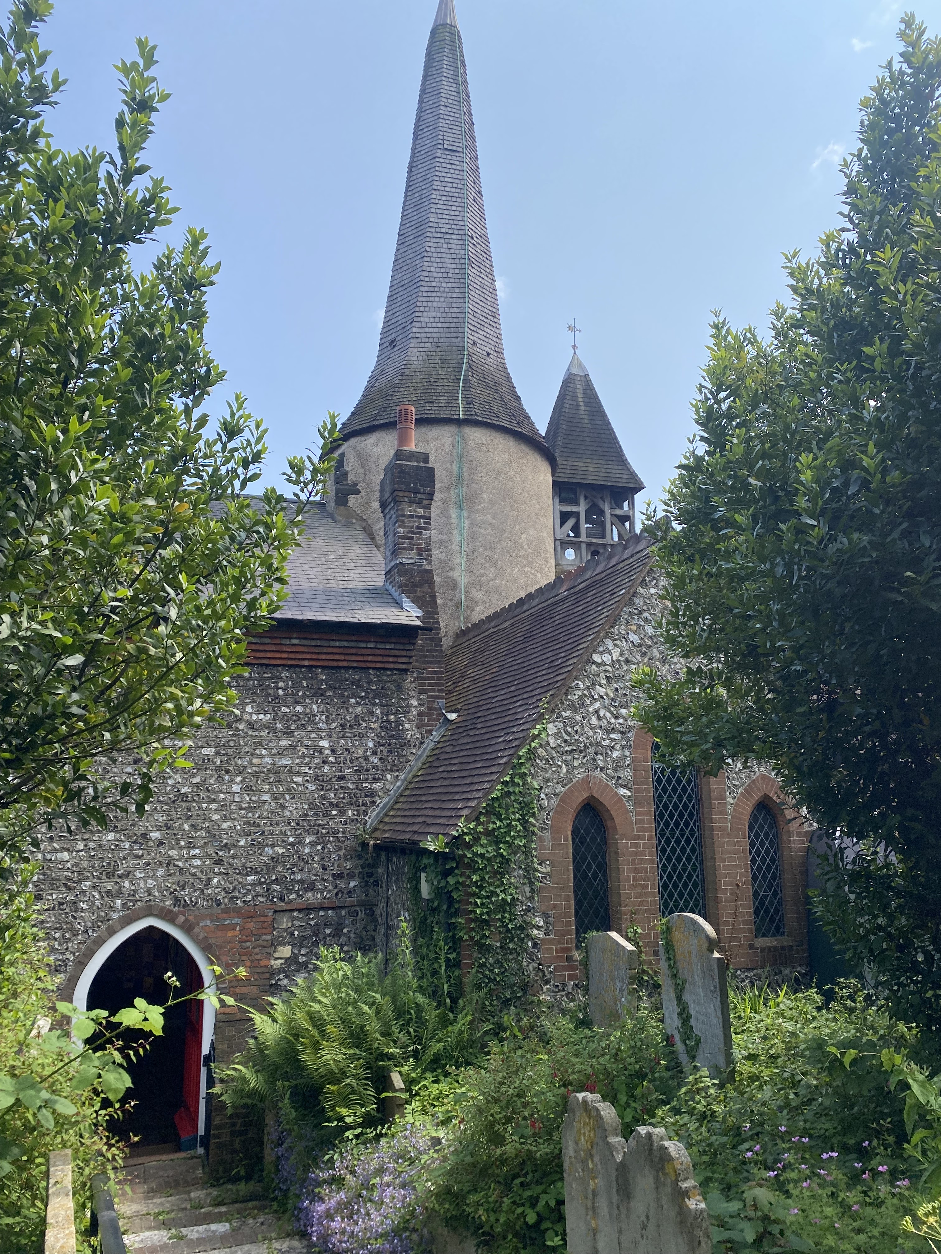
and began my descent off the SDW for Lewes. On the outskirts were the usual red brick houses - along here I crossed the Greenwich meridian just like I did near Paules de Sarsa - and I had a glimpse of one castle tower, then St Michaels church (a distinctive old round tower with a timber cap and a lower timber tower).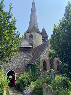
I looked at the castle entrance arches and other tower and walked down the main street - the town was full of historic buildings. 26 kms
16 June Beautiful blue sky as I left Lewes but soon clouded over. I walked along the Ouse River passing some chalk cliffs, mostly up on the river bank. White swans. Looking back I had a great view of the castle on a hilltop above the town. I rejoined the SDW and climbed Itford hill to get a view over Newhaven and the English Channel, even a ferry departing; I'm now very close to the coast. I went along the ridge with constant sea views, up to Firle Beacon, sheep in their paddocks and at one point many young cows sitting beside the trail.
More burial mounds. I descended to Alfriston as the sunshine returned; a pretty village (spoilt by traffic) with many 14-15th c buildings and had lunch at a 14th c pub.


More burial mounds. I descended to Alfriston as the sunshine returned; a pretty village (spoilt by traffic) with many 14-15th c buildings and had lunch at a 14th c pub.


Now I'm taking the inland SDW to Eastbourne because of where I'm staying, and afterwards I'm doing the coast walk heading back west.
I crossed the village green and looked inside the large church then walked unnecessarily around a field looking for access to Windover hill. Once I was up the hill I had to go right back down to be able to see the Long Man of Wilmington, a 17th c hillside decoration of a man, nowadays outlined in breeze blocks.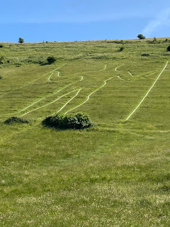
It was hot. Then I was on the tops again with the sheep and suddenly had sea views on both right and left as I headed towards Eastbourne. I left the SDW to go up Combe hill, getting the sight of Eastbourne massively spread out below, and descended a grassy hill to Willingdon. 30 kms

It was hot. Then I was on the tops again with the sheep and suddenly had sea views on both right and left as I headed towards Eastbourne. I left the SDW to go up Combe hill, getting the sight of Eastbourne massively spread out below, and descended a grassy hill to Willingdon. 30 kms
17 June I went back uphill to climb Butts Brow for a view over Eastbourne and beyond, and a couple more hills along the SDW. At the top of the final rise I came to a dew pond and finally the Channel straight ahead. 
I began my descent with a very nice view as the Downs petered out,
and arrived in Eastbourne. The end of the SDW was marked but this wasn't my finish line.

I began my descent with a very nice view as the Downs petered out,

and arrived in Eastbourne. The end of the SDW was marked but this wasn't my finish line.

I walked along a path parallel with the beach; the pebbly beach was divided by a groyne every few metres and it was totally unappealing. Looking back I could see high chalk cliffs. The seagulls were all super-sized. As I got nearer the pier there were lots of people about and the place looked happier. I continued past the pier to my hotel. 11 kms

18 June I walked the length of the beach, which looked ok in the sunshine, and climbed on grass onto the high chalk cliffs towards Beachy Head. I could hear noises that sounded like seals but couldn't see them. Soon I had a glimpse of the red and white striped lighthouse just offshore from vertical cliffs, an impressive sight although along here it was hard to get a proper look at those cliffs.
The path descended then climbed to Belle Tout lighthouse with a better view of the white cliffs; it's quite a dramatic edge to a land mass.
It had been very quiet until I reached Birling Gap with its wide pebble beach backed by beautiful steep chalk cliffs (the Seven Sisters) just as several school groups and a stream of other visitors arrived, so I ducked in the cafe.

The path descended then climbed to Belle Tout lighthouse with a better view of the white cliffs; it's quite a dramatic edge to a land mass.

It had been very quiet until I reached Birling Gap with its wide pebble beach backed by beautiful steep chalk cliffs (the Seven Sisters) just as several school groups and a stream of other visitors arrived, so I ducked in the cafe.
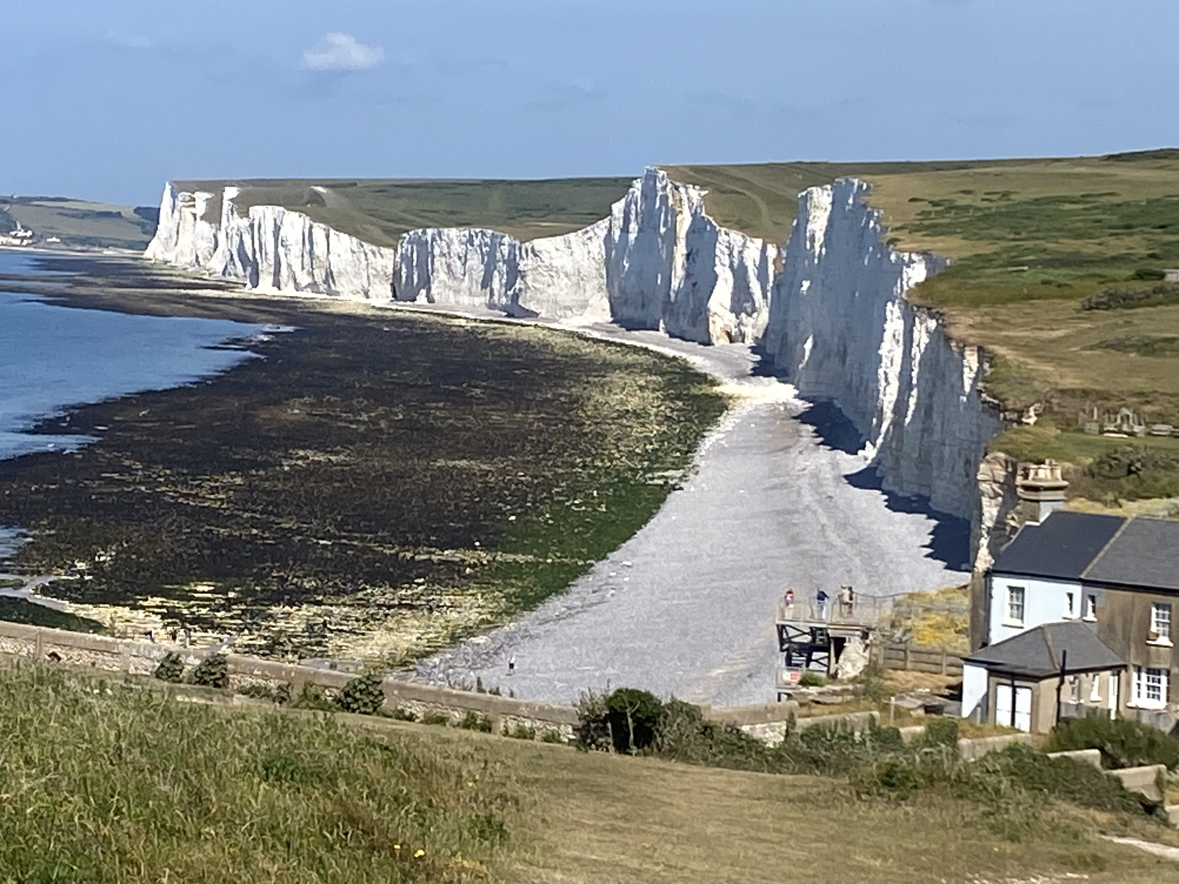
I embarked on the Seven Sisters, a real roller coaster of short but steep inclines on the grass cliff tops. It was wonderful up there, not many walkers and perfect sunshine. Partial cliff views forward, the whole line looking back. I ended with a descent to Cuckmere beach (pebbles) 
and a nice surprise: I could cross the Cuckmere River at its mouth (just got my shoes a little wet) rather than having to go a mile inland to cross. Climbing up on the far side I had another fabulous view of the Seven Sisters to Belle Tout headland,
and continued on the cliff tops after Hope Gap until I came to Seaford Head and a view of the length of Seaford beach, also pebbles.
There were a last couple of chalky cliffs and I was down on Seaford beach. I walked half way along and turned for the town centre, catching the next bus to Eastbourne. 20 kms

and a nice surprise: I could cross the Cuckmere River at its mouth (just got my shoes a little wet) rather than having to go a mile inland to cross. Climbing up on the far side I had another fabulous view of the Seven Sisters to Belle Tout headland,

and continued on the cliff tops after Hope Gap until I came to Seaford Head and a view of the length of Seaford beach, also pebbles.

There were a last couple of chalky cliffs and I was down on Seaford beach. I walked half way along and turned for the town centre, catching the next bus to Eastbourne. 20 kms
Total 209 kms; 4400 m elevation gain; 9 days walking
lovely walks with so many pubs and churches
ReplyDelete