Next I wanted to walk the best part of the GR 1, Sendero Historico. I decided to start in Olite in Navarre, do a long stretch in the foothills of the Pyrenees (Prepirineus - high mountains in themselves but not snow covered), and go east as far as I could in Catalonia, if possible connecting with another trail to continue either to the Med or across the Pyrenees. Organising my accommodation was a challenge on the GR 1 and was the limiting factor on what I could achieve, but this trail proved to be an absolutely fabulous experience and far exceeded my expectations. So many "wow!" moments.
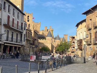
1 May I liked Olite: the fairy tale but authentic castle, the lovely churches and the way the pale stone buildings with red tiled roofs all toned in with the overall vibe.


I left via dirt roads passing fields and vines with a few leaves then started to climb. I was on a rocky path through gorse and other scrub, crossed a canal then back on dirt roads, and looking back I could still see Olite castle. A griffon vulture flew low overhead. I reached a sealed road at the highest point and had a lovely view of Ujue, dominated by its castle-like church, on top of the next hill. 
Getting nearer the views of the town continued and I could also see snow capped mountains of the Pyrenees (in Spain and France) on the horizon (in cloud).

Getting nearer the views of the town continued and I could also see snow capped mountains of the Pyrenees (in Spain and France) on the horizon (in cloud).
The town was busy because it was a public holiday. I sat outside a bar on the tiny square looking upwards at tightly packed houses; 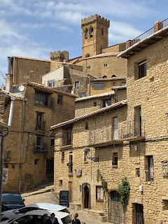
lunch was a plate of calamari, a bola and a pincho of octopus on toast. I went back there for dinner, sausages and bread. The view over the nearby hills and valleys beyond was wonderful and I was able to go inside the church to see the relic of King Carlos 2's hair. The church bells chimed every 15 minutes all night. 16 kms

lunch was a plate of calamari, a bola and a pincho of octopus on toast. I went back there for dinner, sausages and bread. The view over the nearby hills and valleys beyond was wonderful and I was able to go inside the church to see the relic of King Carlos 2's hair. The church bells chimed every 15 minutes all night. 16 kms
2 May I got to the bar at the same time as the barman and he said the bar wasn't opening until 10; he made me a coffee and gave me (unasked) a prawn pincho that had been sitting there since yesterday.
I descended from Ujue and undulated through several green valleys on dirt roads. Nice poppies. Lots of flowering thyme and gorse. I put on my shorts for the first time on this trip, noticed the sky looked black, and within half an hour it was raining, then a couple of thunderstorms. I could see the chapel at the top of Gallipienzo and I rushed towards it but it offered no shelter so I continued down into the village on a cobbled path. This was another pretty village on a hill. 
Very quiet as I descended on wet cobbles, some overgrown paths then crossing the Aragon River on a lovely high arched bridge. I went on to Caseda passing pine trees in more rain and with help I found a bar in the town.

Very quiet as I descended on wet cobbles, some overgrown paths then crossing the Aragon River on a lovely high arched bridge. I went on to Caseda passing pine trees in more rain and with help I found a bar in the town.
I left Caseda going past fields and olive and holm oak trees. Some of the way was a single track in forest which was protected from the wind that was gusting. I passed a few farms and came to a ruined tower on the border with Aragon. The weather had been looking brighter in the direction I was going while very black behind me, but then suddenly I heard thunder, saw lightning and there was a storm centred right where I was. It passed but heavy rain followed and showed no sign of stopping; water was flowing down the dirt road and the mud was really slippery. There was nowhere to shelter. I had this until I was below Sos del Rey Catolico, when the rain stopped. I had to take a path through very wet grass up to the town, which washed the mud off my shoes. I walked through the town, all brown stone buildings and steep streets on the hillside. It was soon raining again. 36 kms
3 May I looked around Sos in sunshine, nobody about: San Esteban church and the castle walls, gates in the surrounding walls, high buildings cramping the streets, views out over the valleys.


I descended into a valley and soon had to cross a flooded causeway, followed a narrow path alongside a stream and climbed into forest of pine and deciduous oak. I had to climb a high gate I couldn't open. The path through the forest was lovely in filtered sunlight and well marked. I heard an animal growling/barking loudly, never saw anything. I had some views out of the forest over surrounding mountains and saw castle ruins on top of one. I descended to a road and when I looked up ahead I could see Petilla de Aragon 120 metres above me on top of a hill - a sweaty walk up. It was a village of two streets (many houses uninhabited) a church and a bar/hotel, with a spectacular outlook across a vast forested valley to the mountains on the far side. 14 kms

4 May I left the village passing a chapel and descended into the valley, mostly in pine forest, and walked through it (had to walk past a confused herd of curly horned cows on the track) before climbing out. I reached the bizarre 10th c Torres de Sibirana on a rock outcrop plus other more recent ruins beside the trail, now in the Sierra de Santo Domingo. 
Continued to a nice blue pool on the river with a small waterfall spilling over rocks. I had a steep climb to a meadow with mountain views and went on up in forest to a pass Collada de Erica Fosa (1120 m). The views were good but I was worried about the black clouds and I didn't linger.
It started raining lightly very soon as I descended on a narrow twisty path through pine trees and there was thunder. I left the forest and followed a river down a valley, the river suddenly went into a tiny rocky gorge for a very short stretch.

Continued to a nice blue pool on the river with a small waterfall spilling over rocks. I had a steep climb to a meadow with mountain views and went on up in forest to a pass Collada de Erica Fosa (1120 m). The views were good but I was worried about the black clouds and I didn't linger.

It started raining lightly very soon as I descended on a narrow twisty path through pine trees and there was thunder. I left the forest and followed a river down a valley, the river suddenly went into a tiny rocky gorge for a very short stretch.
Then I could see the high tower in Biel (the remains of the castle now attached to the church) and the village. I was pleased to find the bar was open so I had a break then went to the restaurant to make sure it was open in the evening; it was supposed to be but wasn't and they made me a sandwich. I had the albergue to myself. 23 kms
5 May Cold as I left Biel. 
A complicated route through the valley before going into holm oak forest and undulating along to a village where the bar was closed (but I wasn't expecting one). Then I descended to a mountain stream, crossed it and had a long climb into the mountains. At a pass was a Romanesque chapel with ruined chevet and a couple of cows grazing. I had to descend on the open hillside and this was obviously the way the cows had come up because it was all a muddy mess. This side had a remote feel and rugged mountains with granite peaks. I continued on a dirt road to San Felices, a tiny village tucked under a mountain, and a nasty dog. I
stayed on the dirt road another hour until I rounded a bend and saw the amazing view of the curious rounded red cliffs Mallos de Aguero.
Aguero was another pretty town under its own granite faced mountain with a decorative church but getting to the town was tricky on an overgrown path.
I was very hot (the sun had come out) and surprised that the bar was closed. I sat by a covered spring to cool down.

A complicated route through the valley before going into holm oak forest and undulating along to a village where the bar was closed (but I wasn't expecting one). Then I descended to a mountain stream, crossed it and had a long climb into the mountains. At a pass was a Romanesque chapel with ruined chevet and a couple of cows grazing. I had to descend on the open hillside and this was obviously the way the cows had come up because it was all a muddy mess. This side had a remote feel and rugged mountains with granite peaks. I continued on a dirt road to San Felices, a tiny village tucked under a mountain, and a nasty dog. I

stayed on the dirt road another hour until I rounded a bend and saw the amazing view of the curious rounded red cliffs Mallos de Aguero.

Aguero was another pretty town under its own granite faced mountain with a decorative church but getting to the town was tricky on an overgrown path.

I was very hot (the sun had come out) and surprised that the bar was closed. I sat by a covered spring to cool down.
The route continued as the Camino Natural de la Hoya de Huesca and the easy walk to Murilllo de Gallego was nice, olive and almond trees on one side and amazing red cliff scenery all along the way. I had a great view of Murillo under its cliffs 
and Riglos further east under another set. In Murillo I found a bar near the elaborate multi-styled church.

and Riglos further east under another set. In Murillo I found a bar near the elaborate multi-styled church.
I went on to Riglos, first crossing the Gallego River (pale turquoise water) and views of the village all the way. In the village looking straight up at the cliff tops 300 metres above the houses was extraordinary. 29 kms

6 May I left Riglos walking beneath the cliffs and entered a gorge with these strange formations all around. 
Saw a few vultures. I came out onto more open hillsides and climbed to a pass Collada Santa Romàn where I could see the snow capped Pyrenees with clouds lurking.
I reached a tiny chapel; not far away there was a ruined tower (one high wall with window slits) and a larger ruined chapel on a prominent rock, a stunning location. It looked out over the vast Gallego valley/Huesca basin with villages, vineyards, olive and almond trees, fields and isolated ranges of hills.


Saw a few vultures. I came out onto more open hillsides and climbed to a pass Collada Santa Romàn where I could see the snow capped Pyrenees with clouds lurking.

I reached a tiny chapel; not far away there was a ruined tower (one high wall with window slits) and a larger ruined chapel on a prominent rock, a stunning location. It looked out over the vast Gallego valley/Huesca basin with villages, vineyards, olive and almond trees, fields and isolated ranges of hills.


The dirt road continued along a ridge in the Sierra de Loarre, sometimes in pine/holm oak forest and sometimes with a clear view of the towering granite faced mountains, always overlooking the valley. Then I descended on a narrow path in forest of deciduous oak and when I came back into the open I could see the backside of Loarre castle perched on a rock (it looked rather small but properly castle shaped), and the village quite far below. I walked down through Loarre and was pleased to find a nice bar open on the square in sight of the gothic church tower.
I walked up to the 10th c Romanesque castle where there was an icy wind and checked it out: the main intact part was the large chapel, good thick perimeter walls, lots of rooms in ruins and towers. 20 kms

7 May Beautiful day but freezing cold. I walked along the upper edge of the valley to Bolea passing through Anies village. Mostly the dirt road was flanked by almond trees with the mountains always in sight. Saw a little chapel on a cliff. Bolea was on a pair of hills, a sizeable place but seemed forlorn with some half hearted businesses and lots of derelict buildings, although the bar was nice and was busy. Until it suddenly closed for the day. My room was a converted bathroom and it had three shower cubicles.
I went to look at the 1540s collegiate church of Santa Maria Mayor on a hill: full of gilded and ungilded renaissance altarpieces and nice view of the mountains from above the church including Peña de Gratal. 11 kms

8 May I left Bolea passing cherry, olive and almond trees heading towards the mountains. I had a very long climb on a rocky path, passing a little ruined convent and went into pine forest. It started raining lightly as I exchanged the forest for open ground. Glimpses of the Pyrenees. I came to a pass (had a pit for storing ice) and went on climbing in moorland with mist swirling around a couple of nearby peaks. Lovely wild flowers. I was close to Peña de Gratal which towered over the Hoya de Huesca yesterday. At the next pass Collada Sarramiana (1400 m) I had nice mountain views but no Pyrenees thanks to the clouds. Then the path descended steeply on rooty and stony ground in beech forest; I briefly emerged to find myself right under Pic Peiro with distinctive limestone ribs, and high above a narrow valley. I went back into the forest to descend to this valley. At a small meadow I saw a black hairy boar run away. I walked down the valley with sombre mountains on each side and lower slopes of bare rock where the topsoil has blown away and came into Arguis, with a basic old church and houses with interesting chimneys and external ovens. I was surprised to find a restaurant and I had a slab of tortilla. My hotel overlooked a reservoir. Late afternoon there was torrential rain and a big thunderstorm. 21 kms
9 May This turned out a great day's walk in the Sierra de Guara. I woke to being in a cloud but it lifted and the sun was out for a couple of hours. I climbed out of Arguis on a shale path wondering how I would get across the autovia and I was surprised when I saw on the map I had walked over it while it went in a tunnel. I continued climbing to a pass at Meson Nuevo, a group of empty houses, and descended into a narrow valley. I was surrounded by green mountains. 
I came to a small chapel and mostly abandoned Belsue. From there I descended into a wider valley and reached a river with water cascading into a pool; it was odd because the rock bed of the river was smooth and yellowy brown unlike the grey of the trail and mountains.


The fabulous mountain views continued. 


I could see ruins on a hill ahead. First I came to a ruined 11th c chapel (brambles inside but good stonework remaining around the doorways, windows and walls).
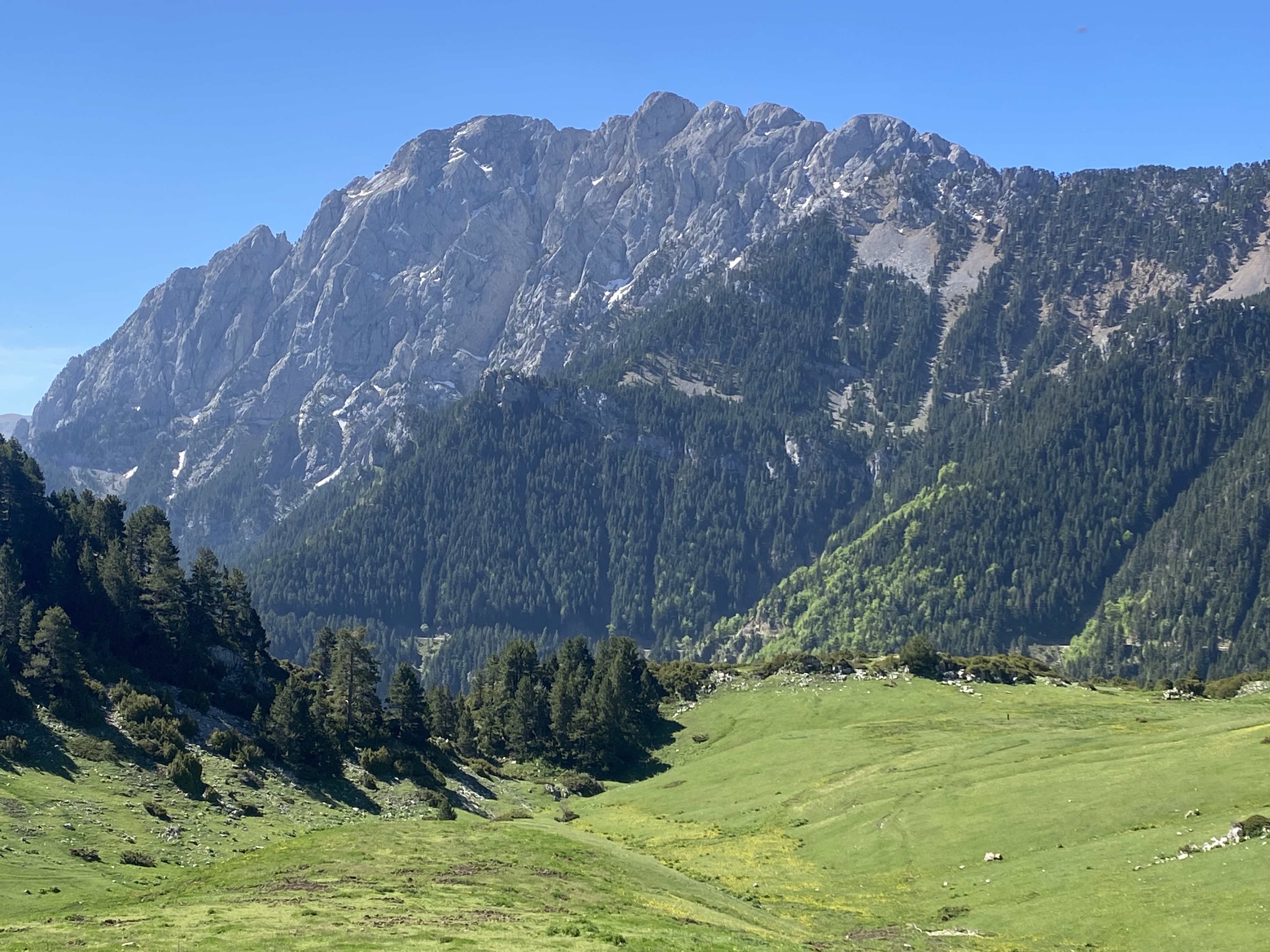
The hilltop ruins were Lusera, an abandoned village; there were workmen there. I crossed another river with rapids and the different rock. I had a steep climb to Collada Santo Coloma where I had a brief rest (worried that rain was coming) and when I rounded the bend I had a wonderful view of Tozal de Guara (2078 m) the top half rock and scree with a few slivers of snow, highest peak in the range, just before its peak disappeared in cloud.
The mountains around me were higher and more rugged as I approached a second pass. Finally I had a long gradual descent towards Nocito (which I could see in the distance), much on bare rock. The path was a bit flooded with water above the stepping stones on some causeways. Nocito had a lovely two arched medieval bridge and seemed pretty closed up until at the end of the village I saw a cafe; they were just closing but made me a plate of ham and cheese. The sun came out and Tozal de Guara was revealed.


I could see ruins on a hill ahead. First I came to a ruined 11th c chapel (brambles inside but good stonework remaining around the doorways, windows and walls).

The hilltop ruins were Lusera, an abandoned village; there were workmen there. I crossed another river with rapids and the different rock. I had a steep climb to Collada Santo Coloma where I had a brief rest (worried that rain was coming) and when I rounded the bend I had a wonderful view of Tozal de Guara (2078 m) the top half rock and scree with a few slivers of snow, highest peak in the range, just before its peak disappeared in cloud.

The mountains around me were higher and more rugged as I approached a second pass. Finally I had a long gradual descent towards Nocito (which I could see in the distance), much on bare rock. The path was a bit flooded with water above the stepping stones on some causeways. Nocito had a lovely two arched medieval bridge and seemed pretty closed up until at the end of the village I saw a cafe; they were just closing but made me a plate of ham and cheese. The sun came out and Tozal de Guara was revealed.

I had views of the mountain all the way to the Rifugio San Urbez (a bunch of French bike riders there), next to the San Urbez monastery. In the evening it poured. 23 kms
10 May Pouring in the morning but I ended up with another wonderful walk. I took the footpath from the refugio to abandoned Bentue; it was quite flooded so I decided to continue on the sealed road (without a single car because it only led to abandoned villages). I was walking alongside a gorge and the mountains were in cloud but it only rained a little. I went past semi abandoned Used and came to semi abandoned Bara in a hollow. 
Here I had to cross a river which I was worried about because of all the rain, but it had stepping stones (under water) and was ok. Back on the GR1 I had a long climb on a rocky path to Nazaré, a ruined village of solitary walls, and I sat for a bit under a door arch that looked reasonably safe. The cute Romanesque church had been reroofed.

Here I had to cross a river which I was worried about because of all the rain, but it had stepping stones (under water) and was ok. Back on the GR1 I had a long climb on a rocky path to Nazaré, a ruined village of solitary walls, and I sat for a bit under a door arch that looked reasonably safe. The cute Romanesque church had been reroofed.

From here the scenery became amazing. I crossed a big plateau of moorland with low mountain peaks in cloud (seemed low because I was high) and views of tiers of mountains northward. 
I detoured to look at a small Neolithic burial dolmen, just three wall slabs and a roof slab and an entrance.
Then I started to descend on a loose stony path and went into the River Mascun gorge with high limestone cliffs to each side. Soon I saw two ibex.
I heard thunder and then had to shelter from a serious downpour. I went on down through the gorge with amazing cliffs ahead;
the path was increasingly scree and wet, and I came to a pool completely enclosed by those high cliffs, huge hollowed out caves or overhangs and a hole in one cliff face.
Lots of rock climbers. Then I had to repeatedly cross the river New Zealand style, right near its source, and I climbed out of the gorge. At the top I could see Rodellar on an adjacent cliff top, quite a position.
I thought I could make it to the village before the next storm but I didn't; another thunderstorm, with hail as well.

I detoured to look at a small Neolithic burial dolmen, just three wall slabs and a roof slab and an entrance.

Then I started to descend on a loose stony path and went into the River Mascun gorge with high limestone cliffs to each side. Soon I saw two ibex.

I heard thunder and then had to shelter from a serious downpour. I went on down through the gorge with amazing cliffs ahead;

the path was increasingly scree and wet, and I came to a pool completely enclosed by those high cliffs, huge hollowed out caves or overhangs and a hole in one cliff face.

Lots of rock climbers. Then I had to repeatedly cross the river New Zealand style, right near its source, and I climbed out of the gorge. At the top I could see Rodellar on an adjacent cliff top, quite a position.

I thought I could make it to the village before the next storm but I didn't; another thunderstorm, with hail as well.
I got to the village and there I had a shock: I thought my room was in Rodellar (Albergue Almunias de Rodellar, a reasonable assumption) but actually it was in another village six kilometres away called Almunias de Rodellar. The owner also operated a taxi and by chance she was collecting someone in Rodellar right then so she picked me up. I had a whole (local) trout for dinner. 22 kms
11 May I bought some food at the campground shop and had breakfast at the hotel in Rodellar and set out with mist all around. The day became quite sunny. I had the hardest climb of the route so far, going almost to the top of a mountain for incredible views of the limestone cliffs of the River Mascun gorge, among best cliffs I've ever seen, and layers of mountain peaks behind (in a bit of cloud). I walked a horseshoe around the rim of the gorge, saw a distant waterfall and all sorts of long overhangs and sheer rock. 


Then I descended in juniper forest on loose rocks and some open scree to a stream that snaked around very prettily and I had to cross it several times, ankle and shin deep. In one place there were little waterfalls in every direction. As I descended I could see a church high up ahead. 
So next I climbed past several clearings (and there were lots of stone walls for no clear reason) up to the church which was in a ruined village, Bagüeste, the other buildings in a terrible state. I could see a bit of snowy Pyrenees.

So next I climbed past several clearings (and there were lots of stone walls for no clear reason) up to the church which was in a ruined village, Bagüeste, the other buildings in a terrible state. I could see a bit of snowy Pyrenees.
I went back down on a flooded track passing more stone walls to a wider river with a short waterfall and followed it to a dirt road; this road went uphill to Las Bellostas which had several houses in disrepair and apparently three inhabitants (I met one). I had a rest outside the church and two Belgian walkers appeared who were doing a week on the GR1 in the opposite direction; we had a long chat which was really nice, mainly about the accommodation difficulties.
I walked down to tiny Paules de Sarsa on the road (to keep my feet dry) with views of the Guara receding and alongside a mountain stream. I crossed the zero meridian marked on the road. My albergue room was very atmospheric with stone walls and timber beams. 27 kms
12 May I spent a long time chatting in French with the owners about this part of Spain and set off late in sunshine. It was agricultural country until Arcusa where I had a coffee just because I could. From there the route went into juniper forest and the trail kept surprising me by forking in different directions. I passed a couple of ruins and had the best views yet of the Pyrenees but still with plenty of cloud. 
I descended to a river and before crossing it the trail became very indistinct as it went through waterlogged meadows, then the crossing was awkward. I came into Castejon de Sobrarbe, semi abandoned with a big church that was being restored. From there I was on the road and making shortcuts where possible in long grass, on tracks across fields and scrambling up embankments.

I descended to a river and before crossing it the trail became very indistinct as it went through waterlogged meadows, then the crossing was awkward. I came into Castejon de Sobrarbe, semi abandoned with a big church that was being restored. From there I was on the road and making shortcuts where possible in long grass, on tracks across fields and scrambling up embankments.
As I reached La Pardina it was beginning to rain; I sheltered in someone's shed to have lunch while it poured for ten minutes. It rained lightly for a bit longer as I continued to Samitier which I could see on the hillside ahead, a prominent church tower. I climbed into another limestone range with extensive views over the River Siusa valley, then descended with views of the El Grado reservoir to Meson de Ligüerre, a mountain looming above the large hotel which constituted the village.
I had to go on the road to little Escanilla, my first busy road on this walk. The people at Paules had told me the owners of the hostal in Escanilla were Belgian and spoke French; I had great difficulty saying this in Spanish to a woman who was not Belgian but Spanish! White asparagus followed by grilled sardines for dinner. 26 kms
13 May I walked back to Meson de Ligüerre and on past Ligüerre de Cinca perched above the lower reservoir to cross the Cinca River and enter the river gorge. 


The limestone cliffs were towering above the water and I could see a chapel and tower on one cliff top. The path through the gorge was amazing: under overhangs, on scree, among trees, with caves in the cliff facing and a sheer drop to the turquoise water. The path then went into forest and through two tunnels (not so nice) and I reached the dam wall. Beyond the dam the upper Mediana reservoir featured the very tip of a drowned church's tower. I then followed along the edge of the reservoir, climbing steadily with cliff views until I exchanged them for the green Fueva valley of fields and the Pyrenees beyond. I descended on a dirt road and soon came across a concrete mixer that might have got stuck in mud and some French 4WD tourists who had to turn around because of the truck. Then I got to Palo with a solid unadorned church.


The limestone cliffs were towering above the water and I could see a chapel and tower on one cliff top. The path through the gorge was amazing: under overhangs, on scree, among trees, with caves in the cliff facing and a sheer drop to the turquoise water. The path then went into forest and through two tunnels (not so nice) and I reached the dam wall. Beyond the dam the upper Mediana reservoir featured the very tip of a drowned church's tower. I then followed along the edge of the reservoir, climbing steadily with cliff views until I exchanged them for the green Fueva valley of fields and the Pyrenees beyond. I descended on a dirt road and soon came across a concrete mixer that might have got stuck in mud and some French 4WD tourists who had to turn around because of the truck. Then I got to Palo with a solid unadorned church.
For the last part I walked along an empty road with nothing but forest and forested hillsides and finally arrived in Salinas de Trillo, tiny village with a pretty Romanesque church and a handful of large houses. The casa rural cooked me a great meal. 21 kms
14 May I declined the wine I was offered at breakfast and watched vultures hovering. As I walked along the road and descended steeply through the trees I could see Trillo with its church perched on the hillside. 
Suddenly the route became a nightmare of waterlogged ground, thistles, prickly bushes and no path in sight. It took ages to get through this, then I climbed towards another village and had a sighting of the Pyrenees almost without cloud and the distinctive flat topped El Turbon (2492 m) with a lot of snow on one face. I climbed to a chapel with a view over the Fueva valley (villages and farms and vultures hovering) and began a long stretch in pine forest around a forested gorge with limestone cliffs, some waterfalls to cross. I could see Pano church on a hilltop and I reached the village, walked through it and ended up on a high ridge with views both sides down to the Fueva valley and the Cinca valley. The trail climbed more and the views got better, even the Pyrenees but now with some cloud.

Suddenly the route became a nightmare of waterlogged ground, thistles, prickly bushes and no path in sight. It took ages to get through this, then I climbed towards another village and had a sighting of the Pyrenees almost without cloud and the distinctive flat topped El Turbon (2492 m) with a lot of snow on one face. I climbed to a chapel with a view over the Fueva valley (villages and farms and vultures hovering) and began a long stretch in pine forest around a forested gorge with limestone cliffs, some waterfalls to cross. I could see Pano church on a hilltop and I reached the village, walked through it and ended up on a high ridge with views both sides down to the Fueva valley and the Cinca valley. The trail climbed more and the views got better, even the Pyrenees but now with some cloud.
From the top I had a long descent in pine forest until I came to Grustan, abandoned in the 1960s after being inhabited since the 11th century, taken over by nature, with a few walls remaining, piles of stones from collapsed walls, the odd timber beam in place, and then on the edge of the cliff was the Romanesque church in top notch condition. 
I began the long walk down to Graus, passing olive groves, the sky completely black almost everywhere except directly overhead, and I saw a well laden walker approaching; we stopped to chat and after a while I thought this must be Christine the German hiker whose blog I've been reading since 2019 - it was! So we chatted a lot more.

I began the long walk down to Graus, passing olive groves, the sky completely black almost everywhere except directly overhead, and I saw a well laden walker approaching; we stopped to chat and after a while I thought this must be Christine the German hiker whose blog I've been reading since 2019 - it was! So we chatted a lot more.
I had been hearing thunder getting closer and I rushed towards Graus. The big church was prominent high above the town. The medieval core was pretty with colourful houses (several storeys high with wrought iron balconies) and a lovely plaza mayor with colonnades and frescoes. I went to my hotel and when I came out five minutes later the storm had started. I had churros then went in the rain to buy new shoes. 25 kms

15 May I left Graus crossing the river on a solid 12th c three arch bridge and climbed into forest with views back to the big church/monastery (long cloister) above the town. For the first time the Pyrenees were totally clear and I saw a new aspect of El Turbon.

I was in forest until the abandoned village of Portaespaña on a hilltop. It had really been overtaken by plants and I had a hard time finding my way because everywhere was so overgrown, and I walked the perimeter twice without intending to, then on the way down I passed the ruined church and had a greater appreciation of the defensive position of the buildings, lined up along the top.

On to Capella on a muddy farm track; another pretty medieval bridge, and a woman escorted me to the bar opposite a pig feed processing plant.


I was in forest until the abandoned village of Portaespaña on a hilltop. It had really been overtaken by plants and I had a hard time finding my way because everywhere was so overgrown, and I walked the perimeter twice without intending to, then on the way down I passed the ruined church and had a greater appreciation of the defensive position of the buildings, lined up along the top.


On to Capella on a muddy farm track; another pretty medieval bridge, and a woman escorted me to the bar opposite a pig feed processing plant.

From there I had awful muddy tracks, the mud stuck to my shoes and made walking difficult and there was plenty of flooded track. I went through a village with an assortment of dogs of different sizes all barking their heads off, then more of the rubbish track. I came down to Laguarres and had lunch by the not very attractive but very large renaissance church.
I didn't need any more fields and mud so I walked along the road to Lascuarre. I stopped at an 11th c chapel (simple inside) and as I left it started raining. Soon there was heavier rain and afterwards loud thunder but the rain stopped. I reached Lascuarre, very steep streets, a fully functioning village with a community bar where I could wait for the pick up I had arranged.
Francisca came to collect me and took me to Roda de Isabena, a restored medieval hilltop village (seemed totally for tourists) with Spain's smallest cathedral: Romanesque, the crypt level with the nave and below the raised main altar, and a nice cloister with a lot of old inscriptions on the columns. We went to her village, Serraduy; she first showed me a furnished cave that she rented out (it was leaking and I was worried that was where I was going to sleep) and then we went on to her real house. 24 kms
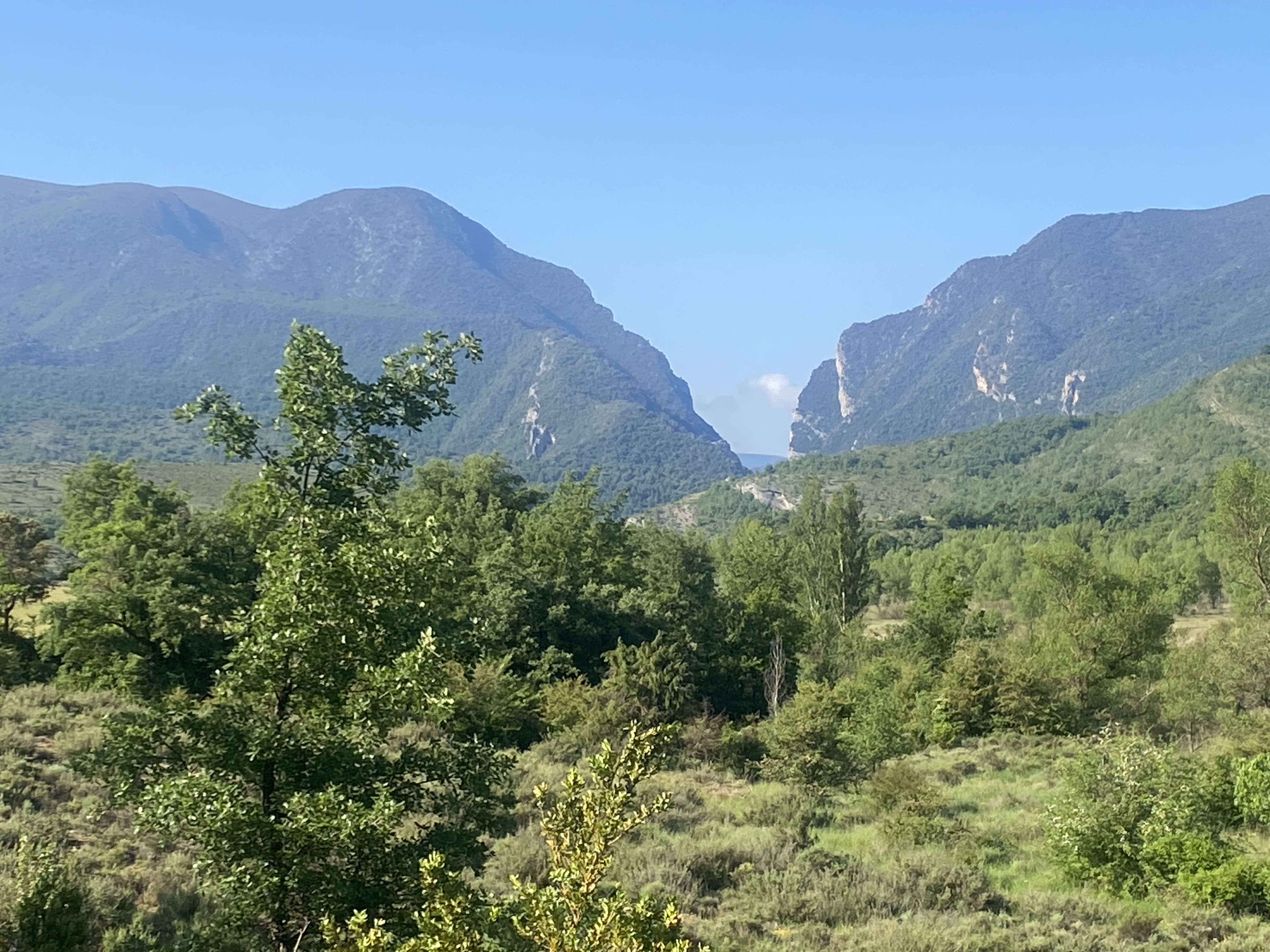
16 May Francisca took me back to Lascuarre and I walked on the road to Castigleu. I had heard from Christine and my guidebook that today would be a day for overgrown paths and getting lost so I had a plan to take a different route for the first half and all went well. It was a steady climb to a bit past Castigleu and I finally got my perfect view of the Pyrenees against a blue sky. 
I could also see the entrance to tomorrow's gorge in silhouette in the other direction. I went into some scrub, then a walled path where the walls had often collapsed, some dirt track with mud that wasn't too sticky and reached Las Badias. This abandoned village still preserved a plaza mayor of sorts with a sizeable church.
I skirted a low mountain and another abandoned but not totally ruined village. Some more farm tracks, some tolerable overgrown trail through small gorges and I came to a ridge with views east. A few clouds came up.

I could also see the entrance to tomorrow's gorge in silhouette in the other direction. I went into some scrub, then a walled path where the walls had often collapsed, some dirt track with mud that wasn't too sticky and reached Las Badias. This abandoned village still preserved a plaza mayor of sorts with a sizeable church.

I skirted a low mountain and another abandoned but not totally ruined village. Some more farm tracks, some tolerable overgrown trail through small gorges and I came to a ridge with views east. A few clouds came up.

I walked the ridge on a lovely walled path going several kms along the San Juan gorge, very rugged country with no houses in sight. Suddenly I saw the church of Montañana on the end of a rocky promontory (where two gorges met at right angles) with the remains of a round defensive tower, and went down to it. 
Then on down to the village which had a proper medieval vibe: old houses packed tight, buildings meeting across the street to form archways that were short tunnels, cobbled streets. From there I had a hot road walk into Puente de Montañana, a bunch of hotels and restaurants on a busy road, and - in an area of endless medieval arched bridges - the puente was a suspension bridge! 29 kms

Then on down to the village which had a proper medieval vibe: old houses packed tight, buildings meeting across the street to form archways that were short tunnels, cobbled streets. From there I had a hot road walk into Puente de Montañana, a bunch of hotels and restaurants on a busy road, and - in an area of endless medieval arched bridges - the puente was a suspension bridge! 29 kms
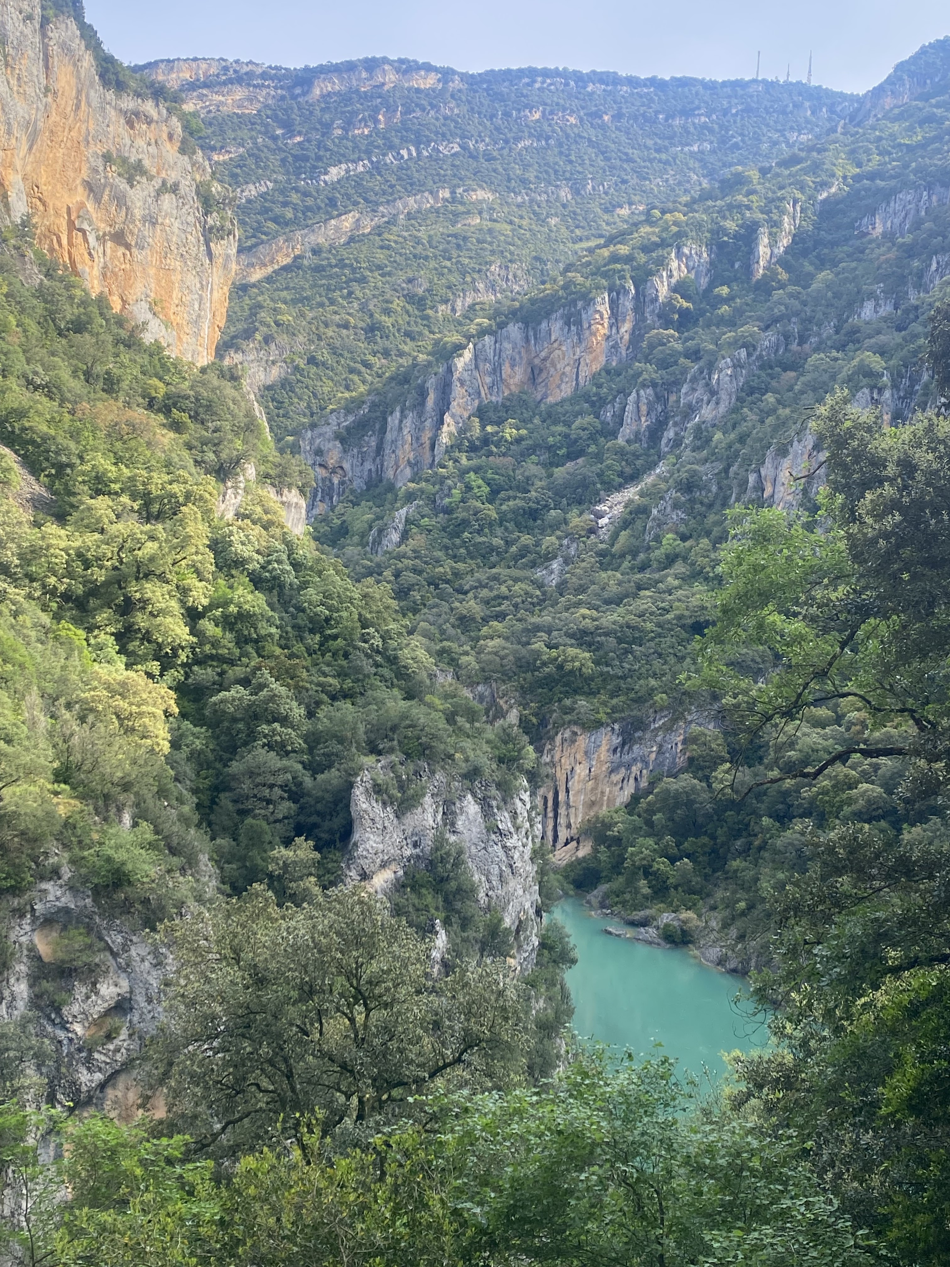
17 May I crossed the bridge and headed off into Catalonia on a long but really pleasant road walk, a second beautiful day. I was going straight towards the Congost de Mont Rebei, a gorge on the Noguera-Ribagorçana River and I could see clearly the two cliffs I had already seen yesterday forming the entrance. 
As I walked I got an increasingly detailed view. There were castle ruins in a field and remains of a lookout tower on a higher promontory.
Masses of cars went past so I knew the gorge would be busy (it was Saturday) and there were more than 70 cars in the car park.
As I walked I got an increasingly detailed view. There were castle ruins in a field and remains of a lookout tower on a higher promontory.

Masses of cars went past so I knew the gorge would be busy (it was Saturday) and there were more than 70 cars in the car park.

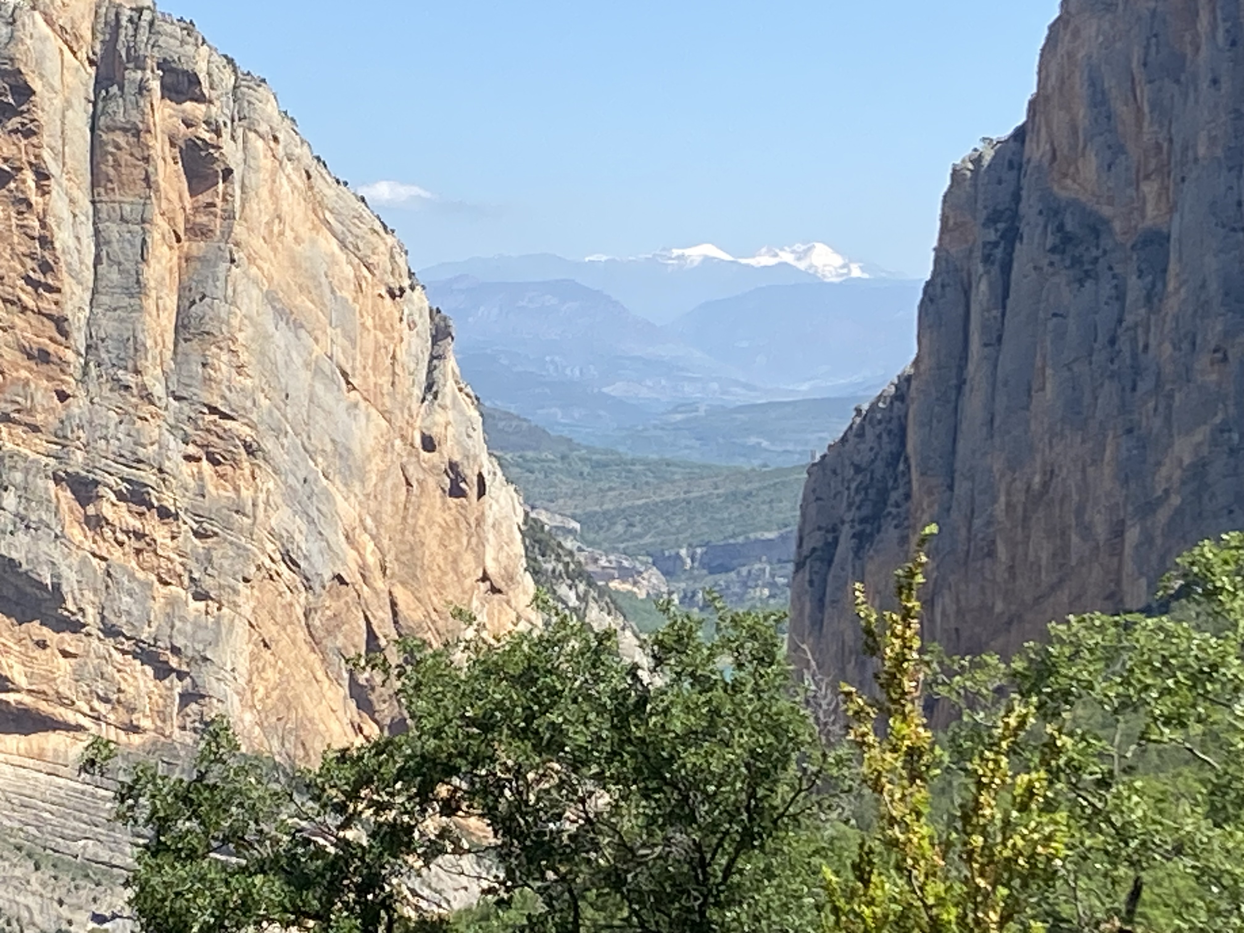
A path followed the river edge, with caves and weird rock formations on the opposite cliffs, and I climbed into the gorge at those entrance cliffs; immediately I was on a ledge under overhanging rock with an amazing view down the gorge.


This was spectacular walking half way up the 500 metre high cliffs, narrow gorge and water below. After about two kms the path climbed in forest and I emerged under a huge wall of rock, Mas de Canies. As I left the closed in part of the gorge I had a very special view looking back at the Pyrenees flanked by the portal cliffs (the river flows from the Pyrenees, cutting the Sierra de Montsec).
There were some ruined buildings and when I stopped some vultures hovered very close by.
The gorge widened and was bordered by lower mountains.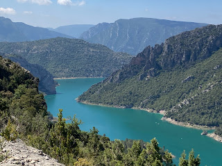
The path went on to more ruins and a view of two chapels, one on each side of the reservoir (on a promontory on my side and on the opposite cliff top).
Finally I walked down a road into Corça; the restaurant had closed down and for the first time I had to ask people for water.

The path went on to more ruins and a view of two chapels, one on each side of the reservoir (on a promontory on my side and on the opposite cliff top).

Finally I walked down a road into Corça; the restaurant had closed down and for the first time I had to ask people for water.
I walked on paths and dirt roads towards Ager in light forest and alongside fields - everywhere is so green and I think I know why - parallel with the Sierra de Montsec. I could see paragliders gliding around the mountains and landing in fields nearby and my hotel was next to the paragliding centre, a way outside Ager. 29 kms
18 May This was a hard day. I walked to Ager (the poppies are still looking great in the fields) and had a quick look at the town, dominated by a Romanesque church, with a small walled medieval core that included an unusual archway over two adjacent streets. 
Then I headed out on the road, which had a good shoulder and no trucks, going towards the Terradets gorge on the Noguera-Palleresa River (the second river that cuts through the Sierra de Montsec). I saw St Oisme castle ruins across the river and an abandoned village as I approached the river, and then the Ager train station a long way from the town; it appeared to be in use but the train that was due never came.

Then I headed out on the road, which had a good shoulder and no trucks, going towards the Terradets gorge on the Noguera-Palleresa River (the second river that cuts through the Sierra de Montsec). I saw St Oisme castle ruins across the river and an abandoned village as I approached the river, and then the Ager train station a long way from the town; it appeared to be in use but the train that was due never came.
At a road junction I began my long strenuous climb into the gorge, initially on a wide path, then on a tiny rocky track which contoured the cliff edge and later on scree. Lots of overgrown rosemary. The gorge from this height appeared as a jumble of interlaced promontories and I could only see a tiny sliver of river. It felt very wild. Beyond the gorge I could see the Pyrenees. 
I passed a couple of ruined farmhouses and an old quarry and went into low box and stunted holm oak forest to climb to ruined Rubies; it took ages to get there but the ruins in a tight cluster were especially attractive. The church had some frescoes and looked out over the gorge. The village was dominated by a massive rock face across the river and one high above. There was a car park at the back of the village and a dirt road, a more normal access route.


I passed a couple of ruined farmhouses and an old quarry and went into low box and stunted holm oak forest to climb to ruined Rubies; it took ages to get there but the ruins in a tight cluster were especially attractive. The church had some frescoes and looked out over the gorge. The village was dominated by a massive rock face across the river and one high above. There was a car park at the back of the village and a dirt road, a more normal access route.


I couldn't work out how to stay on the GR 1 after this point due to a total absence of accommodation for a few days so I made my way off the marked route.
I left on the dirt road, first right among the mountains with only low bushes and grass, climbing further to 1280 metres and then descending alongside a long band of cliffs, Rocas del Arcs (about 70 climbing routes).
Soon I was looking out over a vast valley dotted with villages and after what seemed a very long time I reached Santa Maria de Meia and had a coke at the bar; I was tired but I was under time pressure to reach my lodging. I continued down to Vilanova de Meia and had difficulty finding the bar/rooms where I was staying; the owner came out to look for me. I had my usual sausage, egg and chips and let them close up for the night. I was woken by a loud thunderstorm in the night. 33 kms

Soon I was looking out over a vast valley dotted with villages and after what seemed a very long time I reached Santa Maria de Meia and had a coke at the bar; I was tired but I was under time pressure to reach my lodging. I continued down to Vilanova de Meia and had difficulty finding the bar/rooms where I was staying; the owner came out to look for me. I had my usual sausage, egg and chips and let them close up for the night. I was woken by a loud thunderstorm in the night. 33 kms
19 May There was a partridge pecking around and chirping in the bar at breakfast time. 
I left Vilanova (on a low hill and dominated by its church) and walked along the road towards Artesa de Segre in farmland, lots of poppies, with good views of the Montsec behind. I turned onto a dirt road which was lovely walking, climbing a hill with box trees lining the road, great views over the Segre valley, and descending on a really rough stony path to a village, Alentorn, with a community bar. Then I walked past wheat fields to Artesa with a detour to a hilltop village that looked down over the town. I crossed the River Segre. Artesa wasn't on a hill, didn't have an impressive church and had a small colonnaded plaça major without cafes. It started raining and I got the bus to Balaguer. 16 kms


I left Vilanova (on a low hill and dominated by its church) and walked along the road towards Artesa de Segre in farmland, lots of poppies, with good views of the Montsec behind. I turned onto a dirt road which was lovely walking, climbing a hill with box trees lining the road, great views over the Segre valley, and descending on a really rough stony path to a village, Alentorn, with a community bar. Then I walked past wheat fields to Artesa with a detour to a hilltop village that looked down over the town. I crossed the River Segre. Artesa wasn't on a hill, didn't have an impressive church and had a small colonnaded plaça major without cafes. It started raining and I got the bus to Balaguer. 16 kms


Total so far: 446 kms
21 May After a rest day in Balaguer I got the bus to Oliana, back to the Montsec to rejoin the GR 1. I did a day walk from Oliana heading west along the GR 1 to the village of Peramola, high at the edge of the Segre valley (crossing the Segre on a suspension bridge). The biggest flock of (shorn) sheep I've ever seen was being herded down the road.
I climbed above Peramola into forest of pine and deciduous oak on a steep rough trail with increasing views over the valley, then when I reached the summit of Roc de Cogul I suddenly had views of the Montsec mountains: bare rock vertical cliffs, strange eroded columns and caves, forested lower slopes, the river disappearing between these mountains (to enter the gorge which is the third slash through the Montsec).

Oliana sprawled in the valley but from above Peramola seemed very neatly designed.
I came back down to Oliana in the afternoon heat. My room had a balcony with an excellent view. 16 kms

I climbed above Peramola into forest of pine and deciduous oak on a steep rough trail with increasing views over the valley, then when I reached the summit of Roc de Cogul I suddenly had views of the Montsec mountains: bare rock vertical cliffs, strange eroded columns and caves, forested lower slopes, the river disappearing between these mountains (to enter the gorge which is the third slash through the Montsec).


Oliana sprawled in the valley but from above Peramola seemed very neatly designed.

I came back down to Oliana in the afternoon heat. My room had a balcony with an excellent view. 16 kms
22 May There was cloud right down to the valley when I woke up and as I set off. I crossed a little stream and started climbing through the forested gorge made by this stream. The cloud was clearing in my direction and by the time I reached the chapel of St Just - open - the views were clear for me (but not behind me towards the Montsec). I had a lovely time on a ridge above the gorge and chatted in Spanish with a guy doing a four day walk. The trail climbed higher for great views back to the Segre and over tiers of mountains with bare cliffs and in one place the mountains were back to the reddish conglomerate that featured around Riglos.
Some rocky slopes were covered with pink flowering thyme. I reached 1300 metres above the Collada Serra Seca and could see Cambrils below, then had a steep descent. On the way I checked out castle ruins and a small chapel, and another church above Cambrils. When I got close to the campsite where I had a cabin I climbed over the perimeter fence to save a kilometre. It was sunny but extremely windy and cold all afternoon. 15 kms

Some rocky slopes were covered with pink flowering thyme. I reached 1300 metres above the Collada Serra Seca and could see Cambrils below, then had a steep descent. On the way I checked out castle ruins and a small chapel, and another church above Cambrils. When I got close to the campsite where I had a cabin I climbed over the perimeter fence to save a kilometre. It was sunny but extremely windy and cold all afternoon. 15 kms
23 May Freezing cold when I got up and I was very disappointed to find both the bars in Cambrils closed, so no breakfast. I walked along the road beneath high cliffs, above a densely forested gorge and seeing forested mountain ranges as far as the southern horizon. There were a couple of dramatic rockfalls above the road, huge rocks looking rather unbalanced. When I left the road I stopped at a chapel and descended on a forest trail heading towards the high cliffs flanking a gorge; 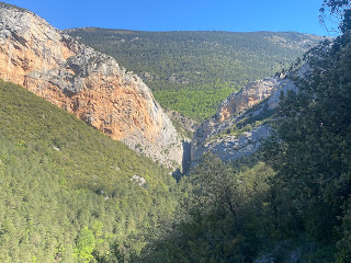
I crossed the little Riu Oden and walked away from the cliffs in holm oak forest, coming to a clearing with a wonderful view north of stacked mountains.
On the other side I was walking above what looked like a valley but was the lower conglomerate slopes, similar to the bare rocky terrain around Arguis.

I crossed the little Riu Oden and walked away from the cliffs in holm oak forest, coming to a clearing with a wonderful view north of stacked mountains.

On the other side I was walking above what looked like a valley but was the lower conglomerate slopes, similar to the bare rocky terrain around Arguis.
I walked for a long time directly below high cliffs (there was a tiny chapel perched at the edge of one cliff top), breaking away to cross a muddy field, seeing a sweet little chapel, descending to a cluster of houses (Cañalda) and then going into more forest, also passing under overhangs and seeing big caves; some were originally used to store vegetables. Some of the cliff faces had sheets of water dripping down. I climbed more and reached the Col de Jou (1470 m) just as a tour bus arrived. I went back into forest and immediately had a view all the way down to Sant Llorenç de Morunys and a bright turquoise reservoir, the Panta de la Llasa del Cavall.
The five kilometre descent started on grassy slopes, went onto a stony track, reached a chapel and then a cobbled path to the outskirts of Sant Llorenç. I was very hot by then and had trouble finding the hotel, then I had difficulty finding an open bar for my first coffee of the day. The town appeared fairly ordinary but in a great setting surrounded by high mountains. Then I found the old part of town, walled with four entry arches, a 10th c Romanesque church/monastery with old altarpieces (very dark inside due to lack of windows) and cloister, and nice plaça major. 28 kms
24 May It was a beautiful day as I left Sant Llorenç. I came to a 16th c chapel with carvings inside and in niches on the outside. I had a long climb on a narrow rocky path in forest, going wrong several times and emerging at a meadow at Cap de Balç at 1400 metres; I could see flecks of snow on the mountains behind Sant Llorenç. Then a very long descent in forest passing a few farmhouses and a chapel with views of forested peaks in every direction (a chapel on one mountain top) to cross a little river.
Back up again, not quite as high, to a hamlet where the cows were having a noisy time with their bells and more views of forest. The trail descended and I had a hot trudge past a big caravan park, then an undulating cement road beside a river. This was just tedious until I came to Presidents lookout and had an amazing view of cliffs on each side of the Aigua d'Ora gorge.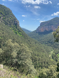
I could also see the 11th c church of Sant Pere de Graudescales deep in the forest;
this was the only sighting I got until I was standing right outside it. It was the prettiest little Romanesque church in great condition with bare stone inside.
I followed the river down to the valley, the water churning over huge boulders, and arrived at the dispersed settlement of Sant Lleir de la Vall d'Ora with interesting rounded cliff faces beyond the buildings. The weather had completely clouded over. 27 kms

Back up again, not quite as high, to a hamlet where the cows were having a noisy time with their bells and more views of forest. The trail descended and I had a hot trudge past a big caravan park, then an undulating cement road beside a river. This was just tedious until I came to Presidents lookout and had an amazing view of cliffs on each side of the Aigua d'Ora gorge.

I could also see the 11th c church of Sant Pere de Graudescales deep in the forest;

this was the only sighting I got until I was standing right outside it. It was the prettiest little Romanesque church in great condition with bare stone inside.

I followed the river down to the valley, the water churning over huge boulders, and arrived at the dispersed settlement of Sant Lleir de la Vall d'Ora with interesting rounded cliff faces beyond the buildings. The weather had completely clouded over. 27 kms
25 May I had great views of the cliffs around Sant Lleir as I left my farmhouse in beautiful sunshine, 
went over an old bridge and started a long climb. I went into forest of pine and holm oak and emerged at a lookout with a fabulous view north, seeing the mountains with snow that I saw yesterday and huge walls of exposed limestone. At the top of the climb were a few houses, and I turned onto another trail for more climbing to Coll del Bosc de Casoliba (1470 m). There were a series of meadows and then a series of viewpoints on rock, all with wonderful views.


I was walking along a ridge, mainly with views south into the valley but also with views of limestone cliffs north. The Pyrenees were in a heat haze. The ridge path continued for many kilometres, going into pine forest, until I had an unexpected view of a ruined church, Santuari dels Tossals, on a slight promontory, and I walked up to it (passing an impressive drop into the valley that was fenced). The bell was preserved in a wooden structure.

From there I had a long descent in pine forest to a few houses and on down in a forest with boulders. I had to cross a stream and I was very pleased I didn't even have to use the stepping stones. Most places seem dry here. I trampled across some fields and got to L'Espunyola; I found a busy restaurant by the roadside and had a coke. It was hot.
That's it for the GR 1. I wanted to get to Gironella quickly so I walked on the road. To Casserres was on a minor road with a few groups of houses, fields with poppies and few cars. Another coke. The rest was on a major road and then I came into Gironella; seemed lively for a Sunday afternoon. 33 kms
567 kms on GR 1
26 May I checked out the medieval bridge which made curious use of a granite mound in the middle of the river for the multiple arches of differing sizes, and the old town of Gironella.
Then I walked along dirt roads towards the mountains and Berga, by the river, passing a pre Romanesque church and farmhouses. Berga was quiet. Here I would be able to link up with a trail across the Pyrenees. 10 kms

Then I walked along dirt roads towards the mountains and Berga, by the river, passing a pre Romanesque church and farmhouses. Berga was quiet. Here I would be able to link up with a trail across the Pyrenees. 10 kms
27 May Berga was completely socked in when I got up and the cloud barely lifted as I climbed steeply out of the town. I had some views over the town and the castle and then nothing once I reached the starting point of the Cami dels Bons Homes GR 107 at the Santuari de Queralt. On the other side it was a bit clearer and I saw some limestone cliffs before descending in beech and box forest. A green lizard ran over my foot. I climbed again and the landscape was much more open with grassy clearings, another large Santuari de Corbera and a few farm buildings. I had a break in a barn because I was worried about the weather and then had a chat with a French hiker finishing the trail. 
A short tunnel just for walkers. More forest and more grassy patches, and some limestone formations, also some old walls, then I reached the pick up point for my off-trail hostal; a couple who happened to be there insisted on taking me instead. The hostal was a stone building on a hillside, beautiful view east of mountains and tiny valleys when the cloud lifted and a nice evening with a group of Danish people. One of them had run the Daytona 100 Mile the same year as me. 16 kms

A short tunnel just for walkers. More forest and more grassy patches, and some limestone formations, also some old walls, then I reached the pick up point for my off-trail hostal; a couple who happened to be there insisted on taking me instead. The hostal was a stone building on a hillside, beautiful view east of mountains and tiny valleys when the cloud lifted and a nice evening with a group of Danish people. One of them had run the Daytona 100 Mile the same year as me. 16 kms
28 May I went past the ruins of Peguera village beneath its own cliff 
and had a long steep climb on a rough path in pine forest, not so dense and there are more grassy clearings than previously.
Soon I was right under a cliff face, Roca Gran de Ferrus, and had to cross scree slopes and go under overhangs (it was rough going),
then I came out onto a grassy saddle, l'Estret (1971 m, the highest I've been on this trip), went back into forest briefly to descend to a pass, Coll del Portet, with views west over mountains and a glimpse of distant snow capped peaks.
Next was a long descent in pine forest until I came to some farms in the valley.

and had a long steep climb on a rough path in pine forest, not so dense and there are more grassy clearings than previously.

Soon I was right under a cliff face, Roca Gran de Ferrus, and had to cross scree slopes and go under overhangs (it was rough going),

then I came out onto a grassy saddle, l'Estret (1971 m, the highest I've been on this trip), went back into forest briefly to descend to a pass, Coll del Portet, with views west over mountains and a glimpse of distant snow capped peaks.

Next was a long descent in pine forest until I came to some farms in the valley.
After that the trails were slow walking because they must have been really churned up by cows when they were boggy and had dried out. I got to a small village and then to a viewpoint over the Cadi-Moixero natural park and the Pedraforca massif (two peaks) and I could see the remains of Gosol castle (a tower and some walls) on a hill beside the town. The centre of Gosol had a more spacious feel than the other towns I've been in. Lots of day walkers around. 19 kms
29 May I went to look at the castle ruins and remains of 10th c church in the old part of Gosol up a steep hill.
Then I had a climb towards the mountains and came to grassy hills at Prat de la Baga with a view towards a mountain range and a little hut, and a col El Collell with a fantastic view of lots of mountain ranges to the east. It was lovely up there with just grass and juniper bushes. I got a great view of the Pedraforca massif, lots of bare rock and a few snow patches, and as I walked along I saw other parts of the mountain, very forested lower down.

This was mid morning and for the rest of the day I was descending, a lot in pine forest on a dirt road but with many mountain views, especially of grass topped Le Dou. It was quite tiring in the heat.
I could see a tiny church in the distance and eventually I reached it, 10th c Sant Marti del Puig; it was open and had a couple of tombs and a ceiling with stars. The trail followed a mountain stream and lastly I went into Baga along the road, seeing huge scree falls above the stream across the valley. Baga had an old part with steep cobbled streets and packed together tall houses. 27 kms

30 May I walked back along the river, passed a little church and headed for the Cadi-Moixero range, taking a gamble on a different trail this morning. Very soon I was in a narrow gorge of high limestone cliffs and the Font del Faig river full of waterfalls and pools.
At one point higher up I had to cross the river several times right by rapids on stepping stones (Arthurs Pass style but less dangerous). I had been pleased to notice three walkers ahead of me, showing this route was possible, but they stopped at the multiple crossings. The path went up into beech forest and when I left the cliffs I had extensive views of mountains south. There were lots of cows up there. I climbed more steeply and reached grassy slopes by Refugi Sant Jordi, on the GR 107 again. I had a coke and continued to Coll del Pendis on open slopes with juniper and pine.

The descent started. Not long after I came to another refuge which was closed; while I sat there some security people arrived to check it was ok. I followed the dirt road down with my route frequently cutting corners on steep slippery paths until I crossed a river by a picnic area and abandoned buildings. The rest of the way was on the dirt road, hot work, with views of mountains to the north. I saw two intertwined snakes having a fun time by the roadside, slithering away together. I stopped at a little church and went on to Tallo which had a big church originating from 975, then to Bellver de Cerdanya. I found a bar and got an enormous wedge of tortilla I couldn't possibly finish.

At one point higher up I had to cross the river several times right by rapids on stepping stones (Arthurs Pass style but less dangerous). I had been pleased to notice three walkers ahead of me, showing this route was possible, but they stopped at the multiple crossings. The path went up into beech forest and when I left the cliffs I had extensive views of mountains south. There were lots of cows up there. I climbed more steeply and reached grassy slopes by Refugi Sant Jordi, on the GR 107 again. I had a coke and continued to Coll del Pendis on open slopes with juniper and pine.


The descent started. Not long after I came to another refuge which was closed; while I sat there some security people arrived to check it was ok. I followed the dirt road down with my route frequently cutting corners on steep slippery paths until I crossed a river by a picnic area and abandoned buildings. The rest of the way was on the dirt road, hot work, with views of mountains to the north. I saw two intertwined snakes having a fun time by the roadside, slithering away together. I stopped at a little church and went on to Tallo which had a big church originating from 975, then to Bellver de Cerdanya. I found a bar and got an enormous wedge of tortilla I couldn't possibly finish.
The older part of the town was nice with a lot of matching stone buildings, and in the oldest part at the top of the hill (above a remnant of wall) were the former public buildings with colonnades and the church. 
It became very thundery. 21 kms

It became very thundery. 21 kms
31 May Crossing the Pyrenees. I left Bellver at 7, surprised to cross the Segre River I crossed in Oliana, and found an open cafe for breakfast just out of town (I was so amazed it was open that I checked several times with a woman standing outside and she thought I was asking for the money to buy a coffee, which she offered me). I climbed steeply on a farm road to a river with a village perched across the valley. The view behind was of the Serra de Cadi cliffs laced with snow. I followed the river to a semi abandoned farmhouse near Viliela, another village perched on a ridge. From there I started a long stretch in pine forest climbing gradually alongside the Riu de la Llosa as I got more into the mountains; the river was frantic with waterfalls, white water and pools. 

I came out onto grassland and passed a derelict hut then a bridge over the river and suddenly no more path, just grass and rocks and some wading across streams.
A few people around. I crossed the GR 11. The trail markings were good, as I climbed towards a semi circle of mountains all flecked with snow: a bowl that was going to be hard work to climb out of.
The sky was looking worse and worse. I worked out which direction the pass was and headed there as directly as possible, having to avoid large patches of snow. Spent a few minutes in Andorra. I saw a couple of walkers up on a ridge.


I came out onto grassland and passed a derelict hut then a bridge over the river and suddenly no more path, just grass and rocks and some wading across streams.

A few people around. I crossed the GR 11. The trail markings were good, as I climbed towards a semi circle of mountains all flecked with snow: a bowl that was going to be hard work to climb out of.

The sky was looking worse and worse. I worked out which direction the pass was and headed there as directly as possible, having to avoid large patches of snow. Spent a few minutes in Andorra. I saw a couple of walkers up on a ridge.
Finally I reached the Portella Blanca pass (2514 m) at the meeting point of Andorra, Spain and France.

At the exact instant I arrived I heard my first thunder clap and the sky over the valley where I was headed was completely black. Bye bye Spain. I had an anxious moment locating the start of the trail down because of the many snow patches and there was a lot of flooding but I soon got going and wanted to descend fast in case a storm came. I had a few drops of rain and then thunder and sunshine at the same time. I found the French side prettier with rugged mountains streaked with snow, streams gushing down the valley, beech and pine trees lower down and the mountainsides covered with flowering broom.

The streams met at a lake, Étang Gros, and at the lower end was a big rockfall and I followed the Campcardos River on down. I saw a shepherd's hut and made for it to rest; it was locked and as I sat outside I had the only bad downpour of my descent. After that there was a proper path, very rocky and I slowly made my way down to Porta, a cluster of brown houses with railway line and busy road. The hotel owner said the pass had only become walkable because of the recent hot weather. 34 kms


At the exact instant I arrived I heard my first thunder clap and the sky over the valley where I was headed was completely black. Bye bye Spain. I had an anxious moment locating the start of the trail down because of the many snow patches and there was a lot of flooding but I soon got going and wanted to descend fast in case a storm came. I had a few drops of rain and then thunder and sunshine at the same time. I found the French side prettier with rugged mountains streaked with snow, streams gushing down the valley, beech and pine trees lower down and the mountainsides covered with flowering broom.


The streams met at a lake, Étang Gros, and at the lower end was a big rockfall and I followed the Campcardos River on down. I saw a shepherd's hut and made for it to rest; it was locked and as I sat outside I had the only bad downpour of my descent. After that there was a proper path, very rocky and I slowly made my way down to Porta, a cluster of brown houses with railway line and busy road. The hotel owner said the pass had only become walkable because of the recent hot weather. 34 kms
1 June I enjoyed my French breakfast of baguette and pastries and three bowls of coffee. I climbed above Porta and above Porté-Puymorens, going under two chairlifts. The mountains looked great in the sunshine. After a path that the cows had messed up (they just stared at me) I reached the car park at Col de Puymorens, and climbed to the Tossal de Mercader (2046 m) from where I saw high peaks in three countries. 
I took off my hat to stage a nice photo and managed to leave it behind so I had to go back up the hill.
Then a long descent down a mountain face to l'Hospitalet Près l'Andorre and a bakery.

I took off my hat to stage a nice photo and managed to leave it behind so I had to go back up the hill.

Then a long descent down a mountain face to l'Hospitalet Près l'Andorre and a bakery.
The rest of the day was nothing special, I just walked near the Ariege River down the valley to Merens les Vals on a track that was often rather vague so I ended up in the nettles a few times. I crossed the old stone bridge into Merens (well remembered from the GR 10) 
and walked up the cobbled path to the upper village. It rained and the clouds came down over the mountain tops. I stayed at the gîte by the old church with no roof but intact tower.
There were three English guys doing the walk the other way. 22 kms

and walked up the cobbled path to the upper village. It rained and the clouds came down over the mountain tops. I stayed at the gîte by the old church with no roof but intact tower.

There were three English guys doing the walk the other way. 22 kms
2 June it was raining and everything in cloud when I got up and I planned a day with three options depending on how the weather turned out. When the heavier rain stopped I had a big climb from upper Merens with cloud swirling over the lower village. I came onto a grassy ridge, still climbing and seeing very little to reach my first decision point; I chose to continue to the cols in case things improved. The path went into yew forest and when I got to the first col I could see absolutely nothing. I went on to the Col de Joux and likewise; it had a shelter so I went inside and soon it was pouring.
After a long wait I was rewarded with a gradually improving view, some backward progress, but finally I had the complete mountain panorama in all directions: high craggy peaks with remnants of snow back towards Porta and mostly forested mountains towards Ax les Thermes.


I started my descent in drizzle on a narrow path through the forest and soon I had taken a wrong turn, ending up at a locked hut; I rectified this and found a dirt road which wound most of the way down to the town, then a tiny walled path and finally the road. By then it was really pouring. It took a while to reach the centre of Ax but I found it, and a cafe where I could have a favourite thing: blueberry pie. Ax was a pretty place with pastel coloured buildings and contrasting shutters, and a central square with plane trees and cafes (of which only one was open). 15 kms


I started my descent in drizzle on a narrow path through the forest and soon I had taken a wrong turn, ending up at a locked hut; I rectified this and found a dirt road which wound most of the way down to the town, then a tiny walled path and finally the road. By then it was really pouring. It took a while to reach the centre of Ax but I found it, and a cafe where I could have a favourite thing: blueberry pie. Ax was a pretty place with pastel coloured buildings and contrasting shutters, and a central square with plane trees and cafes (of which only one was open). 15 kms
3 June Cloud was low over the town. I left passing the thermal baths and an open pit with hot water and embarked on a long climb. Soon I was surrounded by white. 
Somewhat higher I emerged from the forest to see that I was above the clouds and had a wonderful view of the rocky mountain tops streaked with snow. The trail went all the way over a broom covered summit and I had 270 degree views of the mountains.


I started walking along a grassy ridge and the views continued until the Col de Balaguès; this was probably my farewell view of the high Pyrenees. Ahead I could see forested foothills and the village of Montaillou in the valley and I descended steeply. I reached the remains of Montaillou castle, just part of the walls of one tower, with Cathar origins but later rebuilt and destroyed. From Montaillou I walked along a tiny road to Comus, pleased the forecast rain hadn't come. The gîte d'étape was as the top of the village with a view over the valley, and full with day walkers. 19 kms
4 June For a change the day began with a long descent. It was raining when I left as I walked towards the Gorge de la Frau and after a while I was just in a cloud. The gorge started out damp trees and low limestone walls by the dry river; things were increasingly impressive as I got lower down and the cliffs, having become extremely high, closed in on the river. The cloud lifted enough for me to see the tops of the cliffs, but the good part of the gorge was short.
I crossed the almost non existent river and came to a few houses. From there I had a long and frequently steep climb in the forest with a lot of mud. I haven't seen such mud in France before.

At the top I came briefly out of the trees and I could see Montsegur on a hillside: rows of terraced houses. 
The castle (originally Cathar) was in cloud; I waited in the village until the cloud lifted so I could see the castle and I walked the very steep path up to it.
It was perched on an outcrop 200 metres above the village and there wasn't much left, just the outside of the reconstructed main building and some low walls from surrounding houses. The view from the castle was great over a wide valley of small villages and low ranges of hills.

The castle (originally Cathar) was in cloud; I waited in the village until the cloud lifted so I could see the castle and I walked the very steep path up to it.

It was perched on an outcrop 200 metres above the village and there wasn't much left, just the outside of the reconstructed main building and some low walls from surrounding houses. The view from the castle was great over a wide valley of small villages and low ranges of hills.
Then I had a downhill walk to my gîte d'étape in a little hamlet; the owners said the house dated from the Middle Ages. I had met the other occupants last night. 24 kms
5 June Another overcast muggy day but no rain. Before long I was back on a muddy track in the forest; a guy coming the other way warned me about the mud and it was very slippery although not as deep as yesterday. I came out onto a narrow road and continued to Roquefixade with a view of the castle ruins on a cliff above the village.
The hilltops were mostly in cloud. I climbed up to the castle and looked around: a few walls with windows, an archway, some other walls, and very little visible in the valley.
When I got back down I did a bit of path beside fields then decided to go on the empty road and I went through some pretty villages. The road was beneath low forested hills with many limestone pinnacles. A large flock of sheep was being herded up the road towards and then past me by a car driver and the sheep dog got left behind; we had a bit of a standoff, neither able to move forward.

The hilltops were mostly in cloud. I climbed up to the castle and looked around: a few walls with windows, an archway, some other walls, and very little visible in the valley.

When I got back down I did a bit of path beside fields then decided to go on the empty road and I went through some pretty villages. The road was beneath low forested hills with many limestone pinnacles. A large flock of sheep was being herded up the road towards and then past me by a car driver and the sheep dog got left behind; we had a bit of a standoff, neither able to move forward.
I got down to Montgailhard, a dismal place where the GR 107 now ends, and looked for a cafe, then decided to finish my walk in Foix. I found a bakery by the main road and then I had to walk along it until I reached the Ariege River at the edge of Foix, and I walked through the town (pretty medieval centre) with a good view of the castle: a proper castle unlike the recent ruins on my route. Also a large abbey. The castle had three towers, each in a different style and much was original from 12th c onward. So this walk has been castle to castle. The railway station was my finish line (although I soon found the trains were not running). 30 kms


237 kms since Gironella
Olite to Foix: 804 kms; 28420 m elevation gain; 35 days walking, 1 rest day
No comments:
Post a Comment