A long walk from the Atlantic Ocean to the Mediterranean Sea is about to begin, following the GR10 trail the length of the Pyrenees across France. Hendaye Plage to Banyuls sur Mer. Mountains in between. I did not know, as I set out, that France was in the grip of a heatwave and my early difficulties took me completely by surprise. Brian came with me in paperback form and I chatted to him often
July 8 I walked along the Hendaye beachfront 
from my hotel (the beach was deserted) to the start line at the former casino and turned inland. This is the Pays Basque, the foothills of the Pyrenees. It was very muggy. One time I asked a local for directions and he only spoke Spanish.

from my hotel (the beach was deserted) to the start line at the former casino and turned inland. This is the Pays Basque, the foothills of the Pyrenees. It was very muggy. One time I asked a local for directions and he only spoke Spanish.
After leaving Hendaye I followed lanes to a village called Biriatou where I wanted to get a coffee, but the hotel staff ignored me and the only cafe was being renovated. Leaving the village I fell in step with my first fellow GR10 hiker; he was on a faster schedule than me but we chatted for a while as the trail became much steeper. Good views along the coast. Inland many of the mountain tops were in cloud. I began to feel cold. At Col d’Ibardin, in Spain, I was finally able to stop for coffee; it was so cold I sat inside. This was a strange mountain pass with many supermarkets and restaurants strung out along the road; the road was the border between France and Spain. I bought bread, cheese and jamon for dinner. The trail descended and followed a lovely stream; when I came to a stream side restaurant still in Spain I decided to have lunch. I had a ‘cèpes’ omelette with chips and salad. There were lots of casual walkers around. At 2pm the place abruptly closed. I climbed back into France and then descended to a hamlet (on the way down I surprised a large black snake) and then began a long climb to the Col des Trois Fontaines. There were rugged peaks all around and everything was very green, both the mountainsides and down on the flat: green fields and clusters of red-roofed white houses. I had intended to camp at the col but there were lots of horses and cows grazing so I started walking down, looking out for a suitable campsite, and finally I found a patch of flat grass just off the trail and close to a stream, with the constant sound of cowbells. 29 kms 
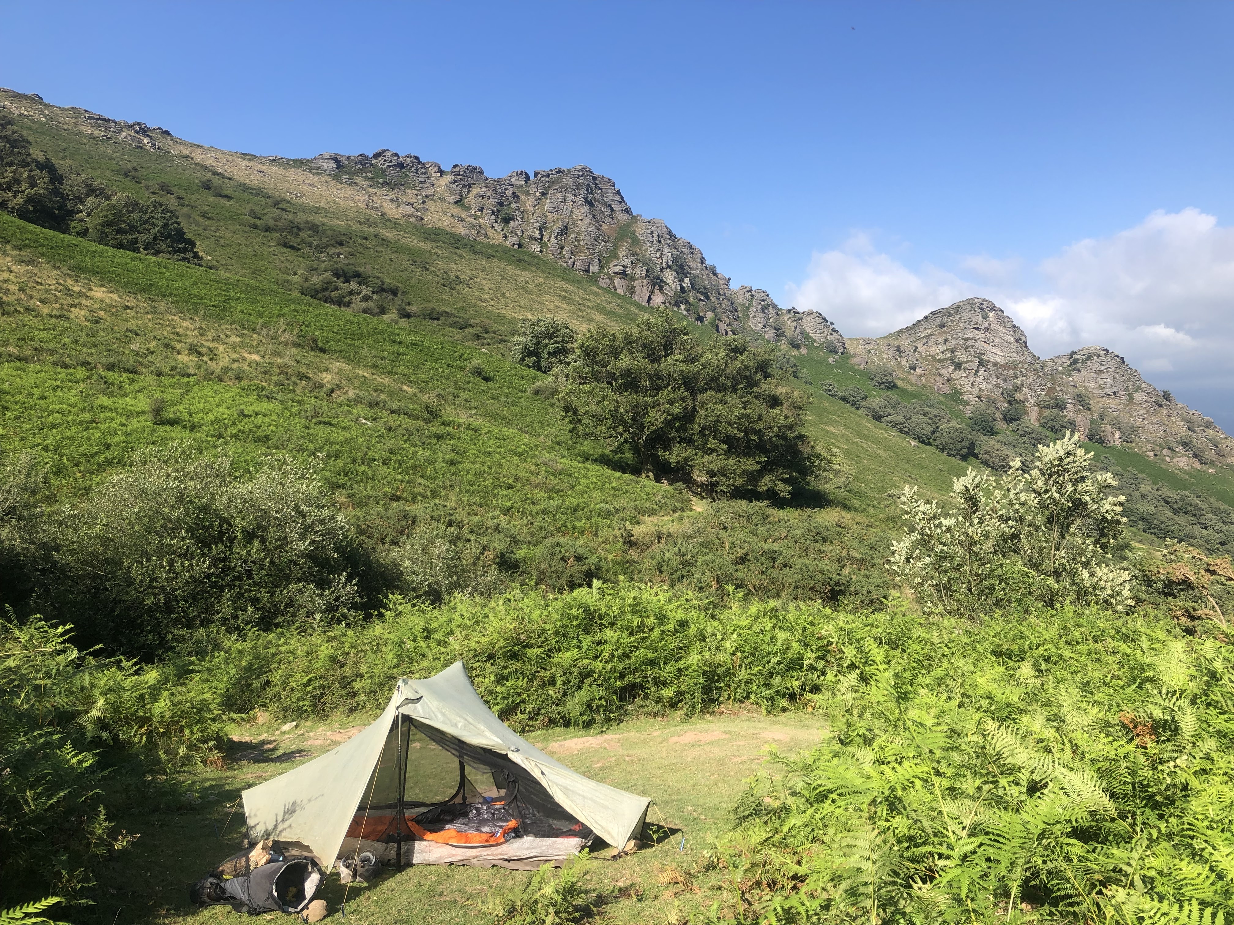
July 9 I woke to see a blue sky and skinny clouds hanging in the valley. I walked into Sare and was surprised to find a fair sized town, so I had a breakfast of coffee and croissant. There was a lot of road walking out of the town and I found it tiring in the blazing sunshine. I followed the Spanish border again then descended to a lovely creek where it was cooler. I should have stayed by the creek all morning but I mistakenly climbed a long hill and had to come all the way back down. Eventually I reached Ainhoa, a small town full of souvenir shops and tourists. I had a local specialty for lunch, a ‘taloa’ which was like a galette, and sat opposite the church. My afternoon walking was hard because of the heat. I struggled along and covered the kilometres very slowly, with green mountain scenery and several grassy saddles. After climbing to an oratorio above Ainhoa I had to choose between going over a peak or contouring and I decided to contour, but something went wrong and I ended up contouring and then climbing. I had hours on a ridge on a ferry hillside passing a few horses. At the Col de Veaux I knew I had to stop but I went a bit further and chanced upon a clearing where two other solo hikers Thomas and André were camping. 28 kms

July 10 Some horses came in the night to chomp on the grass around our tents. I packed up and left early as I was worried about the hard descent ahead. It started very steep and rocky down a vertical cliff face with a wire for assistance in several places. There was a sharp drop off but I didn’t look that way. I was happy to get lower down and then to reach a road above a river. Mostly from here it was full sun road walking into Bidarray. I stopped in the village for coffee with André, so hot that when I arrived I couldn’t immediately talk. André was waiting another hour for lunch (he said it was important to eat properly); I stupidly went on in the heat.
From here I had to climb to the summit of Pic d’Iparla which is the first 1000 metre peak of the GR10. The trail was initially very steep and really difficult on such a hot day; I stopped frequently. The worst thing was the sweat stinging my eyes. When I reached the col before the summit I was pleased as the going was less punishing but the final summit push was awful. The view from the top was of a large number of mountains and there were eagles hovering. 
I didn’t linger because I needed to find some shade. The trail went over a few other peaks with good views of the mountain I had just climbed and its sheer cliffs.
There was a little climbing but luckily a breeze had come up. Sheep and horses were enjoying the grass. I wasn’t going to make it down to the next town as I’d hoped but I kept urging myself to go further even though I was exhausted. There wasn’t any flat ground at the first few cols I aimed for as camping possibilities, then I noticed a tent in the distance; I headed there and joined a guy at Col d’Apoloy who had walked today what I would be doing tomorrow, in reverse. It was flat and the view was of rugged peaks. The sheep came quite close to the tents and stared.

I didn’t linger because I needed to find some shade. The trail went over a few other peaks with good views of the mountain I had just climbed and its sheer cliffs.

There was a little climbing but luckily a breeze had come up. Sheep and horses were enjoying the grass. I wasn’t going to make it down to the next town as I’d hoped but I kept urging myself to go further even though I was exhausted. There wasn’t any flat ground at the first few cols I aimed for as camping possibilities, then I noticed a tent in the distance; I headed there and joined a guy at Col d’Apoloy who had walked today what I would be doing tomorrow, in reverse. It was flat and the view was of rugged peaks. The sheep came quite close to the tents and stared.
I naively thought that I now had one of the hardest parts of the GR under my belt. 22.5 kms

July 11 I saw sunrise over the mountains and made it down to St Étienne de Baigorri for breakfast in the town square. Then I embarked on a climb as hard as yesterday’s, with the stinging sweat in my eyes even worse. After skirting along mountain slopes I headed for a monster of a mountain ahead and it took all my strength to get to the peak, except that this was only a peak en route and I had another 200 metres vert, 1.4 kms, to reach the summit of Munhoa. The last bit was up the grass and I collapsed at the tv mast on top. I ate lunch and came down, mainly on a rough road, and I was delighted to find a bar in the first village. I had a coke. It seemed even hotter walking into St Jean Pied de Port. 25 kms
I had a quick look inside the church. In town most of the bars were closed, only one restaurant was open and there were no supermarkets open but there were masses of people around. I got a table at the restaurant; it was so busy I thought I was in for an awful dining experience but I had a nice meal.
July 12 I bought breakfast and morning tea at the bakery and then left via the pilgrim arch and old town. I wasn’t prepared to wait until 9 for the shops to open. It was very quiet apart from a queue in the pilgrim office. I had a serious climb through ferny paddocks to a small clearing where I sat a while with three grazing horses, until they became too interested in my bakery items. At the top I ate my apple square and walked for an hour down to Esterentzuby looking forward to lunch. I could see the village far below encircled by green mountains. When I got to the village none of the restaurants were open, quite a blow. Hikers kept drifting into the village.
After a coke and my own food I had to climb the other side of the valley. It was very peaceful and when I was tired I lay on the roadside verge. Finally I reached a grassy col and the other way the mountains looked drier and there were no houses. The track contoured the mountain and that was lovely walking to end the day. I found a place to camp by a noisy creek; there were two creeks with good camping but some huge cows had taken over the other spot. 21 kms
July 13 A bit of a nasty climb to start the day and a ridge walk (Brian said ‘easy’) that was definitely uphill.
At one point sheep completely blocked the path, too dozy to move. I had a rest by a prehistoric stone circle (dolmen). At the top were rugged mountain views and then a nice descent through forest. One part had a lot of wild blueberry bushes and the blueberries were delicious. At the bottom was a hotel/restaurant by the river and I had lunch with some hikers. I was pleased that I could easily join in the conversation. When I started out after lunch with more uphill it was hot; someone had mentioned 34 degrees. I made painfully slow progress to reach Irati ski resort, where I was finally able to buy food supplies, and I ate two yoghurts and a mars bar in quick succession. Then I continued to a col near Pic d’Escaliers to camp. Fabulous mountain panorama including some distant rocky peaks, and noisy sheep/cows. 18 kms

At one point sheep completely blocked the path, too dozy to move. I had a rest by a prehistoric stone circle (dolmen). At the top were rugged mountain views and then a nice descent through forest. One part had a lot of wild blueberry bushes and the blueberries were delicious. At the bottom was a hotel/restaurant by the river and I had lunch with some hikers. I was pleased that I could easily join in the conversation. When I started out after lunch with more uphill it was hot; someone had mentioned 34 degrees. I made painfully slow progress to reach Irati ski resort, where I was finally able to buy food supplies, and I ate two yoghurts and a mars bar in quick succession. Then I continued to a col near Pic d’Escaliers to camp. Fabulous mountain panorama including some distant rocky peaks, and noisy sheep/cows. 18 kms
July 14 I was woken before dawn by horses chomping and then as I was getting up a couple of cows decided they wanted to come right inside my tent. I climbed a bit to another col below Pic d’Escaliers; the mountain was hidden from view until I was under it.
I thought the rest of the day would be downhill but I was wrong: although I had a lot of descent I also had some climbing on ferny hillsides and I had real difficulty climbing and breathing at the same time, I think due to the heat/humidity. People are saying France is in a major heatwave. A lot of the walking contoured along hillsides, sometimes below higher peaks and often with massive views of tiers of mountains. I had to stop to rest often and barely thought I could make it down to Logibar. Once there I again had a coke, and a ham sandwich. Then I fell asleep at the table.
As I was about to leave I asked the owner if she knew where I could find an ATM and she said I should get the bus to Tardets about 20 kms away. This was the last thing I felt like doing but I went, with a hiking friend, Lenka. When I got back to Logibar I started hiking into the Holzarte gorge, first with a big climb, passing a huge waterfall. I crossed the Holzarte suspension bridge high above the river, amazing limestone cliffs forming the gorge.
The walking was in the forest and I stopped at a side creek where I camped with Annick and Gilbert. Quite suddenly the heat wasn’t upsetting me. 21 kms

The walking was in the forest and I stopped at a side creek where I camped with Annick and Gilbert. Quite suddenly the heat wasn’t upsetting me. 21 kms
July 15 The day started well with a lot of climbing up to Col d’Anhaou at 1380 metres and a long road contour with wonderful mountain views although a bit hazy. I was finding the going easier, but then as the descent steepened and the paths became rougher I had lots of problems with sore feet: my toes are all raw blisters underneath. I stopped to rest many times and ate lunch by the roadside. After that I went wrong for 500 metres which was annoying.
When I got down to the bottom things got strange: Brian said to walk along the D113 which was a road in full sun without a shoulder, so I was pleased to see a GR sign pointing me onto a track, but this track didn’t show on any map I had so I didn’t know where I was. I stayed on the track, then a narrow road and eventually ended up where I was supposed to be but it was stressful (and I drank untreated stream water out of necessity). I came into the village of Sainte-Engrace and went straight to the auberge/cafe. I hadn’t seen any hikers all day then they all turned up at the auberge. I walked a short way to camp by a farmhouse (the raw blisters made the five minute walk almost unbearable) with Annick and Gilbert and other hikers. 22 kms
July 16 A very long climb in beech forest which I took at a reasonable pace and then I was out on the open tops. I went the wrong way once but corrected with gps. I came to a long switchbacking road to the Col Pierre St Martin where there was just a car park and then descended to the Refuge Jeandel (1698 m) for lunch (ham sandwich with coke) and some chatting. Then I walked down to the ski resort to wait for the shop to open so I could buy bandaids for my feet. I also bought a Camembert which I thought might be a mistake.
From here the trail is in the High Pyrenees. I wanted to return to the GR without backtracking so I followed a route on my gps across a desolate stony area where I saw nobody. After a while I thought I was silly to continue and I was about to turn back for the village, having wasted a lot of effort, when I rounded a bend and was at a junction with the GR. Very happy. The landscape was completely different on this side of St PM: limestone rubble everywhere, huge limestone formations and pine trees. It was really quiet (which didn’t click at the time was due to the absence of cowbells). I climbed to a place where two ski lifts met, far from the resort, and climbed again to a notch called Pas de l’Osque between two high limestone peaks. Then I descended slightly to another notch for an amazing view of two mountains with a saddle between: Pic d’Anie was the higher.
As I came down to the Cabane du Cap de la Baitch to camp I could see the shepherd rounding up sheep above the cabane. I started putting up my tent near the cabane but the woman at the cabane, selling cheese, said I should move because the cows were going to be there in the morning, so I moved, then the daughter came and said I was still going to be in the way; third time I found a lovely spot among boulders beneath the mountains. My feet were so sore that I crawled around on my knees. I ate my very runny Camembert. 20 kms

As I came down to the Cabane du Cap de la Baitch to camp I could see the shepherd rounding up sheep above the cabane. I started putting up my tent near the cabane but the woman at the cabane, selling cheese, said I should move because the cows were going to be there in the morning, so I moved, then the daughter came and said I was still going to be in the way; third time I found a lovely spot among boulders beneath the mountains. My feet were so sore that I crawled around on my knees. I ate my very runny Camembert. 20 kms
July 17 I descended further into the beautiful valley in the shade and then undulated through woods. When I emerged I had a fantastic view of massive mountain Le Billarde 
and soon came to a refuge where I stopped. There were loads of walkers around. I descended to Lescun (all grey roofs in these parts) which had the biggest shop I’ve been in since Hendaye; I bought a slice of blueberry tart and sat at a busy cafe.

and soon came to a refuge where I stopped. There were loads of walkers around. I descended to Lescun (all grey roofs in these parts) which had the biggest shop I’ve been in since Hendaye; I bought a slice of blueberry tart and sat at a busy cafe.
I crossed a noisy stream in forest and climbed above Lescun then descended to grazing land to cross the same stream and people were picnicking in their bathers there among the munching cows.
I had another big climb and two groups of walkers coming down said “courage” so I knew it was a hard climb. At the col there was no view except of pine trees but seconds later I had a wonderful view on the open hillside looking straight at Pic du Midi d’Ossau and a long mountain range in front.
The descent of 1000 metres was rather tedious in the heat; I crossed a few streams but it was mostly on ferny hillsides.

The descent of 1000 metres was rather tedious in the heat; I crossed a few streams but it was mostly on ferny hillsides.
I was exhausted when I reached Borce and I wanted to stay there but the gîte didn’t do meals so I struggled another kilometre to Etsaut and directly to the only restaurant, planted myself there, made a booking, ate. I had to camp in the town so I went down to the river and made myself as hidden as possible; it was stifling hot in my tent. 25 kms
July 18 I made myself coffee in the centre of Etsaut and walked out of town. I had an interesting walk along a ledge cut into the limestone cliff face centuries ago, Chemin de la Mature, with a sheer drop to my right. It went for several kilometres, climbing into a gorge. The climb continued in beech forest until I reached a shepherd’s hut where I had a rest; two hens were very sure I had something they needed.
After that the trail went up the valley and it became hard work because of the blazing sun. 37 degrees today. Many switchbacks later I passed a minor col and then the Col d’Ayous at over 2000 m with a fantastic view towards Pic du Midi d’Ossau, and Lac Gentau in the valley.
I descended to the lake in great pain from my blistered feet and had lunch but there was no shade. I continued down past two more lakes and through forest. It is all very beautiful, being so high above the valley and seeing so many rugged mountains, but the discomfort of the heat really detracts from my enjoyment. At the bottom was a reservoir and an unexpected snack stand where I had a long sit.

I descended to the lake in great pain from my blistered feet and had lunch but there was no shade. I continued down past two more lakes and through forest. It is all very beautiful, being so high above the valley and seeing so many rugged mountains, but the discomfort of the heat really detracts from my enjoyment. At the bottom was a reservoir and an unexpected snack stand where I had a long sit.
It only remained to descend another 500 metres to the village of Gabas where I was going to try to get a room and definitely a meal. The walk down was on a sealed road alongside a stream and took forever.
Then things went pear shaped. Firstly the épicerie was closed on Mondays (I didn’t even know it was Monday), then both restaurants were closed (permanently?) and the gîte was taken by a group. Toilets but no water. After some pleading the gîte owner sold me a baguette and said I could camp across the road and have breakfast at his. So the village was a dump but I still had a mountain view from my tent. 26 kms
July 19 I had a substantial breakfast, a shock to the system, and then I almost felt it slowed me down! I climbed in forest (this route would be impossible in the heat without all the forest) to a stretch along a ledge below cliffs with a vertiginous drop, much narrower than yesterday’s ledge but much shorter. More forest and I made good time. I emerged into the open for panoramic views and a rest.
The trail was amazing after this: I came into the Cézy valley (where I made a quick detour to sneak water from a cabane trough)
and went up onto a ridge high above the Soussouéou valley, with a stream running down the middle and ending at a mountain range.
I followed this ridge then turned to follow high above another stream. It was windy off and on which was pleasant. The path got narrow with a slippery edge. I had lunch where the trail crossed the stream and while eating I watched a herd of sheep arrive to dine on the opposite hillside. A German hiker (f) came by and we chatted. I came to a little lake and passed a patch of snow and found a nice place to camp at 2000 m, right beneath Hourquette d’Arre; after the last two days I intended to have a shorter day.
Later I went to get water from the stream and when I got back another bunch of sheep were moving to pasture near my tent. My first thunderstorm! 15 kms

and went up onto a ridge high above the Soussouéou valley, with a stream running down the middle and ending at a mountain range.

I followed this ridge then turned to follow high above another stream. It was windy off and on which was pleasant. The path got narrow with a slippery edge. I had lunch where the trail crossed the stream and while eating I watched a herd of sheep arrive to dine on the opposite hillside. A German hiker (f) came by and we chatted. I came to a little lake and passed a patch of snow and found a nice place to camp at 2000 m, right beneath Hourquette d’Arre; after the last two days I intended to have a shorter day.

Later I went to get water from the stream and when I got back another bunch of sheep were moving to pasture near my tent. My first thunderstorm! 15 kms
July 20 The final climb to Hourquette d’Arre was hard, on shale chips with small patches of snow. At the top it was windy and a wonderland of craggy peaks with thick cloud filling the valley. I was on a plateau for a while and had breakfast by the path above a lake. As I left the cloud was starting to engulf the lake and I walked almost to Gourette in cloud. Masses of people were walking up (where there’s a lake there are people) and many asked me the same question: was it clear on top? I learned a new word: dégagé. I think the lack of view made the descent easier. As I came into forest I passed a large school group, and when I crossed the creek I came into sunshine. Gourette was compact with lots going on. So I washed, ate and shopped. Annick and Gilbert appeared while I was having lunch and questioned if I had arrived on the GR!(Because I’d been so slow when we crossed paths before). 9 kms
July 21 Gourette was already busy first thing because the Tour de France was coming through. (I expected to see the race at the next village Arrens Massous but as it turned out something was lost in translation.) I climbed above the resort soon meeting up with Annick and Gilbert and we reached the Col des Tortes for a view over a lush valley. 
The trail descended into the valley and proceeded to cross or parallel the main road for a long time. All along the road cars and camper vans were parked waiting for the cyclists. The descent took all morning so I went into Arrens Massous for a break, thinking this was where the Tour stage ended, but sadly I was wrong and the riders turned off at the col where I had seen a particularly large number of camper vans. So that’s how I didn’t see the Tour de France. (I heard later that A and G had also been confused about this.)

The trail descended into the valley and proceeded to cross or parallel the main road for a long time. All along the road cars and camper vans were parked waiting for the cyclists. The descent took all morning so I went into Arrens Massous for a break, thinking this was where the Tour stage ended, but sadly I was wrong and the riders turned off at the col where I had seen a particularly large number of camper vans. So that’s how I didn’t see the Tour de France. (I heard later that A and G had also been confused about this.)
In the afternoon I did quite a lot of road walking, looking towards some amazing mountains.
I walked alongside a fast flowing creek and chatted with a New Zealander; later we had a drink together and it turns out we have mutual Kiwi friends Chris and Tom. We camped at a campground by Lac d’Estaing. The mountains rose vertically above the campground. 26 kms

I walked alongside a fast flowing creek and chatted with a New Zealander; later we had a drink together and it turns out we have mutual Kiwi friends Chris and Tom. We camped at a campground by Lac d’Estaing. The mountains rose vertically above the campground. 26 kms
July 22 The campground was asleep when I left at 7 45 to start the thousand metre climb to Col d’Ihéou. I plodded along steadily through forest then onto open hillsides, passing cows being organised. I stopped briefly near a cabane but I wanted to keep going because I was still in shade. The last part was a series of grassy bowls and I could see the col tantalisingly ahead. When I arrived there was a line of jagged peaks in silhouette. The descent to the refuge was quick and the refuge was beside beautiful Lac d’Ilhéou tucked into a cirque. I had a snack of two thick slices of bread with cheese and almost shivered in the shade.

I came down on a mix of trail and dirt road. At half way I went into thick cloud. I followed a gushing creek with several waterfalls. It was such a long descent my feet were really sore and I tried to avoid the rougher tracks. I heard some strange noises as I got lower and eventually realised I was under a cable car. Cauterets was much bigger than I expected, a busy town, completely socked in and cold. I had a ham sandwich and a coffee in the town centre, did some shopping and set off again.
I followed a fairly boring trail to La Raillère where there was a surprising line of restaurants and souvenir shops near an impressive waterfall; unfortunately I went the wrong way after this wasting a lot of time and effort. I righted myself and headed for the Pont d’Espagne, which involved a trail alongside the river passing many huge waterfalls. I was still in cloud. The path seemed endless, constantly climbing and very rough and I was really tired. I was relieved to reach the bridge, a high stone arch over another waterfall, and started looking for somewhere to camp. I followed the road towards a refuge and saw somewhere pretty by the river where it was lined by pines. As an aside, the slugs are really supersized here. 28 kms

July 23 The cloud lifted in the night but was back by morning. I prepared breakfast sitting outside the closed restaurant nearby and continued to follow the creek uphill; within half an hour I was above the cloud with the sun shining on mountain peaks. I came to a refuge by a lake and went on to the next refuge at Oulètes de Gaube much higher up, still a rocky path but now on grassy hillsides. It was a real alpine wonderland especially as I approached the refuge; it had a perfect view across meadows towards Vignemale with its (grubby) receding glacier. Soon a large contingent of noisy Spanish people arrived.

I thought the climb to the Hourquette d’Ossoue would be hard but it was comfortable with good switchbacks and I reached the highest point on the GR at 2734 metres. The Spaniards continued on to climb Petit Vignemale and looked like a line of ants up there. I descended slightly to the Refuge Baysselance 
and had an omelette. The temperature was pleasant.

and had an omelette. The temperature was pleasant.
The views on the way down were fantastic - lots of powerful waterfalls, patches of snow, rugged peaks, scree fields - but the walking wasn’t nice; apart from the steepness there were some nasty surprises including a couple of difficult creek crossings and a snow overhang that I had to sidle under without falling into the creek. Luckily there were two of us there at the time. Almost all walkers around here are Spanish. Lots of marmots. I was exhausted when I arrived at the reservoir at the bottom. I walked a little further and found a flat campsite by a stream, always good for be surrounded by mountains and sleep to the sound of trickling water. 22 kms
July 24 I continued high above the valley floor to the tunes of cow bells.

The valley narrowed almost into a gorge then widened as I approached the paved road; cyclists were struggling uphill. On one steep hairpin bend a marmot’s scream made me jump. I arrived at the refuge Grange de Holle pleased to see it was open. It was a lovely spot. I bought four sandwiches, three to take.


The valley narrowed almost into a gorge then widened as I approached the paved road; cyclists were struggling uphill. On one steep hairpin bend a marmot’s scream made me jump. I arrived at the refuge Grange de Holle pleased to see it was open. It was a lovely spot. I bought four sandwiches, three to take.
I climbed onto a ridge for great views over the town of Gavarnie far below a massive cirque (many patches of snow). 
The trail passed several little farms and it was hot. I came to a gîte bang on lunchtime and - a welcome surprise after my previous interactions with gîtes - it was open for food, and I had an omelette (and commiserated about the heat with my snow sidling friend).

The trail passed several little farms and it was hot. I came to a gîte bang on lunchtime and - a welcome surprise after my previous interactions with gîtes - it was open for food, and I had an omelette (and commiserated about the heat with my snow sidling friend).

Then I climbed some more, ending up on a ridge on Som Haut which felt like being on top of the world. I came down in woods then forest, went wrong for a while and descended a lot more in forest. My planned camping place didn’t materialise so I got water from the river and waited for somewhere suitable; I ended up on a patch of grass near farm buildings. 25 kms
July 25 I woke up in a cloud. After a road walk I turned into the forest and soon lost the trail. I came across a hut with no obvious means of access and pushed my way back into the forest following gps; when I saw a scree slope above me I decided that the trail must cross it - I was right and rejoined the trail. Phew. At the highest point was a small iron cross and an opening in the trees but no view today. I came down to Saint Sauveur, crossed high above the river and walked into Luz-Saint-Sauveur where it was market day and extremely busy. Lunch was the €15 set menu comprising sliced duck, paella and chocolate mousse. The cloud never lifted. 11 kms
July 26 I have set myself an easier week. I had a long steep climb out of Luz, all in cloud and a lot of walking through wet grass/ferns. Fairly soon a strange thing happened: the painted GR waymarks stopped. I plodded on and passed one GR signpost. Then there was nothing. I turned to my gps and let it guide me to Barèges since nothing accorded with the description in my guidebook. I saw nobody for three hours then a couple of cars and a farmer at work. Half an hour from Barèges I saw a GR waymark completely out of the blue and had a few more into town. I was relieved to get there and when I looked at the map in my guidebook I saw I had gone exactly the right way. The bakery had run out of bread and had one sandwich left, chorizo and tomato.
I had a stop for coffee at Tournaboup ski area (a stock standard smelly ski snack bar) and began the long climb to Col de Madamète. Soon I was in cloud.
As long climbs go this one was nice: not too steep, some boulder hopping for variety, beautiful pine trees and gushing creeks. 
I was determined to climb above the cloud before camping and I had a long wait. At 5 pm I suddenly saw blue sky and the sun for the first time today. I was presented with wonderful mountainside views and little lakes.
I walked on towards the col and camped at the first rock-free patch of grass I saw; it was idyllic except that the cloud followed me upwards.
I fell asleep early and woke at 9 30 to see the last of the sun on the peaks around me, the cloud gone, and a perfect starry night followed. 25 kms

I was determined to climb above the cloud before camping and I had a long wait. At 5 pm I suddenly saw blue sky and the sun for the first time today. I was presented with wonderful mountainside views and little lakes.

I walked on towards the col and camped at the first rock-free patch of grass I saw; it was idyllic except that the cloud followed me upwards.

I fell asleep early and woke at 9 30 to see the last of the sun on the peaks around me, the cloud gone, and a perfect starry night followed. 25 kms
July 27 The trail passed a series of small lakes before the rocky/bouldery final ascent to the Col (2509 m). The view here was great with a lake and backdrop of jagged peaks. 
I descended a bit to another lake in a lovely setting
and then worked my way towards Col d’Estoudout. This climb was among pine trees and some workmen were building steps on the path. At the col the view was of peaks rising above cloud, but the direction I descended there wasn’t so much cloud. The pine-lined descent was steep and rooty. At the bottom I stopped for lunch by Lac de l’Oule.

I descended a bit to another lake in a lovely setting

and then worked my way towards Col d’Estoudout. This climb was among pine trees and some workmen were building steps on the path. At the col the view was of peaks rising above cloud, but the direction I descended there wasn’t so much cloud. The pine-lined descent was steep and rooty. At the bottom I stopped for lunch by Lac de l’Oule.
Off for my third col of the day. I climbed above the lake watching slivers of cloud move around. The trail contoured the grassy mountainside passing under several chairlifts until I reached Col de Portet. There I found an unexpected snack bar so I had a coke and a bounty. I could see my destination, village of Vielle-Aure, way down (1415 m down) in the valley. I hadn’t intended to go all the way there today but once I started on the descent I thought I might as well finish it. 
As long descents go it wasn’t too bad but the final part seemed to take forever; each time I got a window view over the village I was still high above it. Some of the descent was along a fence so I felt right at home. As I came into the village, soon after passing my friend from the snow sidle, I noticed a building that said Chambres d’Hôtes and on the spur of the moment I went in and was able to stay there. It was a different sort of evening for me with all the talking and eating; I just wanted to go to bed. 27 kms

As long descents go it wasn’t too bad but the final part seemed to take forever; each time I got a window view over the village I was still high above it. Some of the descent was along a fence so I felt right at home. As I came into the village, soon after passing my friend from the snow sidle, I noticed a building that said Chambres d’Hôtes and on the spur of the moment I went in and was able to stay there. It was a different sort of evening for me with all the talking and eating; I just wanted to go to bed. 27 kms
July 28 The morning’s walk went uphill through several villages, across grassy hillsides to a col (people paragliding) and then steeply downhill to Loudonvielle, a town which seemed remarkably ordinary. After some shopping (bread, chocolate) I did the very steep climb to Germ (45 minutes to Brian’s hour) and then, remembering that I’m meant to be having an easier week, I went into the auberge for an omelette. I had a direct view across the valley to the col and paragliders. After a long break I climbed the steepest 100 metres of the trail so far and then traversed hillsides. I felt bad weather coming and I made for Cabane d’Ourtiga, and it soon rained. Later on lots of hikers turned up to camp there including a French teacher, Laurent, with whom I chatted a lot. 18 kms
July 29 There were thunderstorms almost all night and it was windy but my tent held up. I ate breakfast in the hut; the rain was coming and going then it hailed. I left for the steep climb to the col and soon it was raining and hailing. The thunder began again and lightning. At the col there was nothing, no sign, no view. I didn’t enjoy the descent in the thunderstorm with intermittent hail. Once I tried to shelter under a rock and I was hopeful of shelter when I saw a hut but it was locked. The last part of the descent was in forest, muddy and very dark. I saw some weird bright yellow lizards. I was delighted to see signs of civilisation far below and four wet hours after setting out I came to an auberge. The rain was constant as I drank coffee.
Just after midday the rain stopped and the sun came out; it was great to feel warm again. I climbed on a good path to Lac d’Ôo and ate lunch admiring the waterfall at the far end of the lake. 
Then I made the brutal climb to Lac d’Espingo high up in some very rugged country. This was a demanding climb with endless tight switchbacks and I was in a race with the rain. I won. I put up my tent on a grassy ledge above the valley, close to the refuge so I could use their facilities. 15 kms

Then I made the brutal climb to Lac d’Espingo high up in some very rugged country. This was a demanding climb with endless tight switchbacks and I was in a race with the rain. I won. I put up my tent on a grassy ledge above the valley, close to the refuge so I could use their facilities. 15 kms

July 30 I slept in a cloud and climbed in cloud with only occasional moments of seeing my surroundings, which must have been rugged. I was crossing grassy bowls beneath rocky peaks between two cols. At the first col I saw nothing and at the second I got lucky and saw high peaks above the whiteness, rock scoured by glaciers, several tiers of distant mountains. The descent on grassy slopes wasn’t very interesting as I saw nothing and it seemed to take too long to reach Superbagnères ski resort. I had a last conversation with Laurent, whom I caught by surprise sitting in the fog; we were less than 50 metres from the resort buildings but couldn’t see them. When I got there it was a dismal place. I must remember not to go skiing there. I went into the only open cafe for coffee and a crêpe, and they closed as I left.
The walk down in forest (pine then beech) was ok although the switchbacks went on for a very long time. I went right into Bagnères de Luchon, a day early so I decided to stay two nights at the hotel I had booked for tomorrow. I think this is half way. 19 kms, just over 500 kms total.
July 31 Day off.
August 1 I am moving into the Ariège section of the trail. My right foot is very sore and in Luchon I could barely walk so I hope it loosens up. The first few kms out of Luchon really bothered my foot, but then the climbing started, in oak woods, and was less painful. I reached Artigue which was a hamlet of stone buildings and caught up with a German hiking buddy from Estaing. From here the climbing was on open hillsides leading to a ridge with a great view over Luchon and the area I had walked in the fog two days ago. I bumped into Kiwi James. We came to a col and then a peak, following the Spanish border marker stones, and at the peak were a large group of French walkers having an elaborate picnic. We watched vultures playing on the air currents.
Then a descent of 1800 m. At first on the grassy hills with everything very green, passing two cabanes and going into forest. There had been no water in any of the streams. Then the trail followed a stream with water, a relief as it was hot and sunny. I came into forest with a switchbacking trail down at a pleasant grade. My foot seemed to have loosened up well. At the bottom was a canal and then a main road, quite an odd sight. I continued into Fos and to the bar/restaurant where I saw James, and soon the German siblings arrived so we all had a drink. We camped at a grassy area by the Garonne river, small here. 30 kms
August 2 I walked out of Fos, which was a very long village with a customs post at the far end. A long climb on a switchbacking road for a couple of hours, passing solitary houses with views of forested hills to Melles. Then the trail steepened, crossing little creeks (with water today), going into woods and finally emerging onto a boggy plateau covered in purple heather. It was a beautiful sunny day. As I approached a cabane I had to walk through a flock of sheep and soon three patous (sheepdogs) came running over snarling at me; they were really ferocious looking and I pointed my sticks at them as I crept past. (I had originally intended to have a break at the cabane.) The trail went along a ridge with great views and descended to Étang d’Araing, a reservoir with a refuge.
I decided to push on as the refuge was unpleasantly busy. I climbed (again) to Serre d’Araing (2221 m) where there was a view into another valley. Then I descended into this valley which was full of mining relics and abandoned cottages. The first part of the descent was a nice contouring path but the rest was rough not only due to the rocks but also rusted mining debris on the trail itself. I came into forest, pleasantly cool, and reached Eylie-en-Haut where I found a spot to camp by the river. 26 kms
August 3 I crossed the valley and climbed for two hours, always able to look down on Eylie.
Just before the col I noticed blueberries beside the path and stopped to eat handfuls. The blueberries continued for a while. I started to traverse the valley on a variant trail, GR10E, which I had picked for a change of scenery and also so I could eat/buy food in Bonac. This trail was in places very narrow and the path hidden by long grass. It seems hotter.

Just before the col I noticed blueberries beside the path and stopped to eat handfuls. The blueberries continued for a while. I started to traverse the valley on a variant trail, GR10E, which I had picked for a change of scenery and also so I could eat/buy food in Bonac. This trail was in places very narrow and the path hidden by long grass. It seems hotter.
I descended in deciduous forest, the ground thick with leaf litter, and got very close to Bonac when the trail suddenly changed direction and the remaining distance doubled. I have never walked 3.5 kms so fast.
Worse was to follow. When I got to the cafe/shop in Bonac (lovely village beside a river) I found a group of women inside who said it was closed for the summer; apparently the owner had been asked to do some renovations and as they hadn’t been done the Mairie had said they couldn’t serve customers. There was nowhere else with food in the village. I explained my urgent need for food to one of the women (I felt bad about this but I really had to eat) and she prepared me a meal in a box, but said I couldn’t eat it there, so I sat by the river. I enquired about the village where I intended to camp and they said there was a good restaurant there.
I climbed through a couple of villages and descended towards Les Bordes sur Lez. I had some views of a high rocky peak and down into the valley dotted with huts. Les Bordes was stretched out and it took a while to reach the restaurant at the far end. Which was closed. On Wednesdays. Today. I couldn’t believe it. I asked a couple standing nearby if there was anywhere else to eat or a shop and they said no. The woman offered to take me to the town of Castillon en Cousserais 3 kms away as she was just going there, so I went with her, went to the supermarket, ate several things and - since there was no bread left in town and I would need to wait until tomorrow - I camped at the town campground. 24 kms
August 4 By 7 30 I had bought bread, eaten breakfast in Castillon and got a ride back to Les Bordes. The trail climbed maybe the steepest yet and was then in green forest, crossing a few pastures and with views over large villages. I found some ripe blackberries. I came to a disappointing lake (too green) and continued on the GR10D to Col de la Core. Suddenly I was back on the tops with extensive mountains on the horizon, and as a bonus there was a snack bar (because there was a car park). Another customer said “chapeau” to me on hearing what I was doing. 

From here the scenery changed dramatically to forest with granite cliffs and big boulders. It started raining solidly. I sheltered under a rock overhang. Then I made a dash over the open hillsides for a cabane, which I found had an unlocked shed; there was even a chair so I sat in the doorway. I watched three donkeys who were clearly not happy with the weather and were trying to shelter under the narrow overhang of the cabane roof. There was a lot of thunder. Once the rain cleared I walked on, crossing a low col into the head of the next valley, with high rocky mountains above. I descended into a wonderful mossy forest where the path was too slippery for comfort, following a creek downhill. Eventually the creek ran through meadows. When I got to the bottom I put up my tent by another noisy stream. It was soon raining again. 26 kms
August 5 Back on the main GR10. I climbed alongside my sleeping stream passing some impressive waterfalls but also a few dry ones. It was muggy with thunder in the air. I got a glimpse of a high peak before the cloud covered it. Once out of the forest I got snatches of views of the craggy mountain range and soon after I reached Cabane d’Aula the sky cleared. The view was superb: steep sided mountains, small glaciers, snow patches.

The path from here was one of the highlights of the GR with the high serrated range, pointy Mont Valier, grassy meadows and horses grazing, all in brilliant sunshine.

From the Bouche d’Aula, a grassy bowl, I descended, still with the views, to another unattractive green lake, then headed steadily downhill with high densely forested mountains all around. 
I came down through a few hamlets where three people asked me how I managed in the heat (and I thought it wasn’t too bad today). I arrived at a gîte at a farm and asked to bivouac (since I couldn’t get a room to myself and I wouldn’t be able to stay awake for dinner). 24 kms

I came down through a few hamlets where three people asked me how I managed in the heat (and I thought it wasn’t too bad today). I arrived at a gîte at a farm and asked to bivouac (since I couldn’t get a room to myself and I wouldn’t be able to stay awake for dinner). 24 kms
August 5 I lost a filling while eating breakfast. I had a steep climb to Col de la Serre du Cot where the view was completely obscured by cloud,
but it was clearing as I descended so I got some views of high forested mountains and saw an ibex disappear into the forest. As I came into St Lizier d’Ustou the sky was blue. I liked the village for its stone church, open restaurant (for my coffee) and open shop. I didn’t want to leave.

but it was clearing as I descended so I got some views of high forested mountains and saw an ibex disappear into the forest. As I came into St Lizier d’Ustou the sky was blue. I liked the village for its stone church, open restaurant (for my coffee) and open shop. I didn’t want to leave.

Then a steep climb again. The Ariège has a liking for this. When I emerged from the forest I had magnificent window views over the green mountains 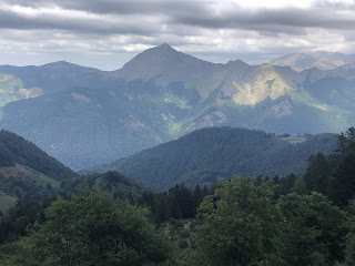

and the views continued as I walked over a col and upwards to the Chalet de Beauregard restaurant (which was well placed for views in all directions), and it was open.


and the views continued as I walked over a col and upwards to the Chalet de Beauregard restaurant (which was well placed for views in all directions), and it was open.
The sky was black towards the mountains and storms were forecast so I lingered at the restaurant for over an hour; nothing happened so I got going. I had a wonderful walk into the cirque above the chalet and then descending alongside a stream which was basically a series of waterfalls. 
The thunder continued the whole time but no rain came. I walked all the way into Aulus Les Bains and to the campground. Fortunately there was a restaurant on site so I didn’t have to go back into town. Very average but at least it was food. 25 kms; 30 days on the GR.

The thunder continued the whole time but no rain came. I walked all the way into Aulus Les Bains and to the campground. Fortunately there was a restaurant on site so I didn’t have to go back into town. Very average but at least it was food. 25 kms; 30 days on the GR.
August 7 Another long climb, to Port de Saleix, a col, first in dry forest until I reached a car park (where Sunday mass was being held) and came into an open bowl surrounded by high peaks. It was harder work from here but near the col there were plenty of blueberry bushes for distraction. 

From the col the trail climbed straight up the mountainside, which seemed mean, but then I noticed lovely Étang d’Alate below so all was forgiven. I finally had a swim.
The terrain was all granite boulders and the mountainsides were a mosaic of rock and grass . It was actually quite a weird look. Soon I had a view of a whole series of lakes, Étangs de Bassies, as I came down to the refuge to camp.
Once again, hearing lots of thunder, I thought a storm was coming, and it got cold, then a brief downpour and that was it. 11 kms

The terrain was all granite boulders and the mountainsides were a mosaic of rock and grass . It was actually quite a weird look. Soon I had a view of a whole series of lakes, Étangs de Bassies, as I came down to the refuge to camp.

Once again, hearing lots of thunder, I thought a storm was coming, and it got cold, then a brief downpour and that was it. 11 kms
August 8 I descended on the very rocky path past all the lakes (passing the refuge Gardien running uphill to work), crossed the stream outlet from the lakes and continued slowly down, passing many people coming towards the refuge. I reached the main road and briefly went the wrong way.
I had a road walk then turned onto a walled path which felt historic, and came into Olbier, a village with a cheese shop and a church, which looked like somewhere right out of the Middle Ages - only room for a drain down the middle of the street, no cars.
When I got to Goulier I went into the gîte for a drink and had a long conversation with an English/Australian hiker.

When I got to Goulier I went into the gîte for a drink and had a long conversation with an English/Australian hiker.
The next stage is one Brian describes as ‘easy’ and for the first time he was right. The path climbed gradually to a series of cols, in a mix of pine forest and open ridges, with some ripe blackberries. I saw a viper with a zigzag patterned skin. The long, winding descent to Lercoul and on to Siguer was fairly smooth. I camped by the river on the edge of the village. It wasn’t great: the area was well illuminated with an orange light and the church bells sounded every half hour all night. 25 kms
August 9 In terms of climbing today would have to be my hardest on the GR, with over 2300 metres of ascent. It was a big effort but sadly the scenery was nothing spectacular. I began with a brutal climb out of Siguer. I paused at a viewless col to chat with a hiker; I found his speaking so fast and complicated I needed to get away to have energy left for walking. At the end of that climb I came onto a grassy peak quite on top of the world then followed a ridge and descended to a meadow. It was peaceful rather than dramatic. I had another steep climb in woods to a grassy col across the valley, then another long descent in forest. By then I was worn out but I had another big climb, which started so steeply that I had to take several breaks. There had been distant thunder all afternoon and I waited for the rain; after the worst of the climb I came to a grassy area with a cabane and a Spanish guy there who was keen to chat. Just then the rain started. While it rained I listened to how the Spaniard had crossed the Pyrenees seven times. Then I completed the day’s walk, arriving at Plateau de Beille ski resort, and camped. 22 kms

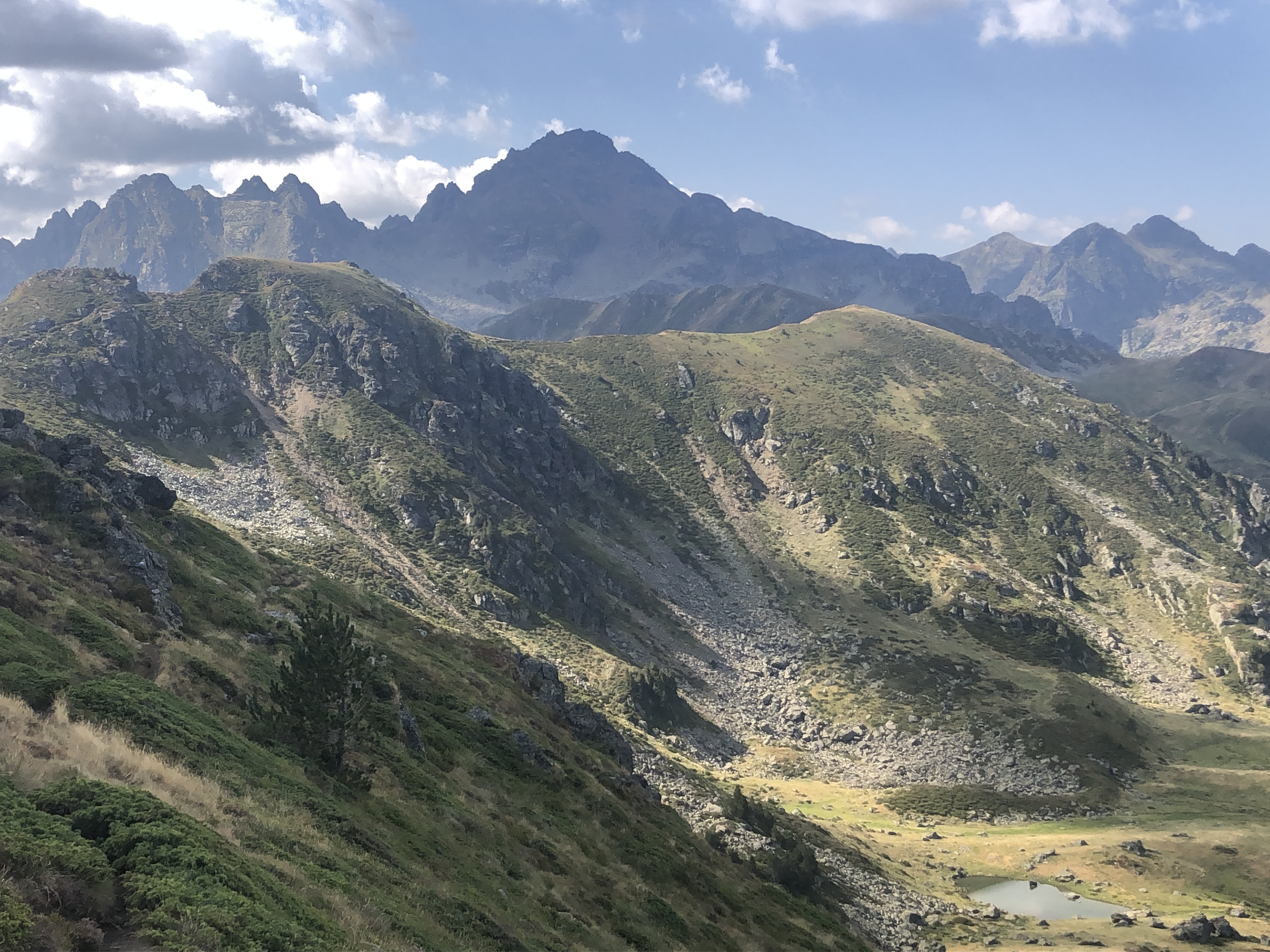
August 10 Today was another highlight of the trail and I wished I wasn’t so tired from yesterday. After climbing along grassy tops for a while, chatting with hiker Gilles, with good views of mountains in France and Andorra, I came into a pretty cirque and then climbed to the Crêtes d’Izard, a rocky ridge several kilometres long.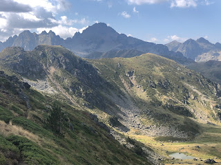
It went steeply up and down with some scrambling but mostly I was on the very crest and the views to both sides (tiny lakes, lots of craggy mountains, grassy valleys) were amazing. Someone had made a rock arch over the track. I came to Refuge de Ruhle and ate an omelette with a wonderful rocky mountain view. I watched a snake-hunting eagle searching for prey.

In the afternoon I had to cross huge boulder fields which was slow going but spectacular scenery including a couple of small lakes. 
The trail kept on climbing, even when I thought it should have finished, until I came onto a ridge at 2400 metres
and crossed into the next valley. Then all downhill to Merens Les Vals. I had decided I was due for a scenic camp in the mountains so I walked on until I came to a stream in a lovely hanging valley and put up my tent on a rare flat patch of grass. I noticed I was right among blueberry bushes. 21 kms

The trail kept on climbing, even when I thought it should have finished, until I came onto a ridge at 2400 metres

and crossed into the next valley. Then all downhill to Merens Les Vals. I had decided I was due for a scenic camp in the mountains so I walked on until I came to a stream in a lovely hanging valley and put up my tent on a rare flat patch of grass. I noticed I was right among blueberry bushes. 21 kms

August 11 I stopped for breakfast above a small lake and continued down. Not far out of Merens a hiker came past and said “C’est Julia“; it was Thomas I camped near at Col des Veaux on my second night!
I took a long break at the cafe in Merens. Merens had only one feature: an extremely busy road running through the centre. I’ve finished the Ariège.
Into the Pyrenées Orientales. The 1300 metre climb out of Merens started innocently, passing hot springs (quick leg bath) and a waterfall (quick leg bath just above it) but after a few kilometres it became really steep and rocky. It felt endless, always another steep slope ahead. I passed a lake 
and came to the last climb but that one had several false summits. It was a rugged landscape of vast boulder fields and scree.
To add insult to injury there was a huge downpour two minutes after I reached the col.

and came to the last climb but that one had several false summits. It was a rugged landscape of vast boulder fields and scree.

Going down was quite different in a green valley with pine trees. It rained more and then a thunderstorm when I reached the Refuge des Bessines. Then hail. More thunderstorm. Then plenty of rain. At least I got to use my rain pants after carrying them for five weeks. Everyone went inside except me; I sat on the deck watching the weather. I walked a little way to camp in an alcove formed by vegetation. 17 kms
August 12 Beautiful clear sky. More climbing on rocky paths but in a less boulder strewn landscape. It was wonderful at the Col de Coma d’Anyell 
and I sat for ages chatting with Claudia, a roller skater. On the other side was a green valley which I traversed so I could climb to another col. From this one I looked down onto a very long valley, whose entire length I had to walk.
This wasn’t hard but took hours. The trail then followed the edge of a very large lake, Lac de Boullouse. I thought I would be walking along the lake shore but the path undulated constantly. Nothing is easy on the GR. Eventually I reached the dam wall and walked across it to a restaurant. The area was phenomenally busy but I couldn’t see why. I was only interested in the restaurant, where I ate a slice of Spanish omelette and a slice of blueberry pie.

and I sat for ages chatting with Claudia, a roller skater. On the other side was a green valley which I traversed so I could climb to another col. From this one I looked down onto a very long valley, whose entire length I had to walk.

This wasn’t hard but took hours. The trail then followed the edge of a very large lake, Lac de Boullouse. I thought I would be walking along the lake shore but the path undulated constantly. Nothing is easy on the GR. Eventually I reached the dam wall and walked across it to a restaurant. The area was phenomenally busy but I couldn’t see why. I was only interested in the restaurant, where I ate a slice of Spanish omelette and a slice of blueberry pie.
I was about to leave when Laurent arrived; we were both very surprised. Four of us went to camp at a nearby lake. Shortly after we got there a thunderstorm started and then enormous hailstones. Then the cows came to visit and stayed all night. 20 kms
August 13 I really felt I needed a rest day and to do some serious eating so I planned to walk the two hours to Bolquère and stay there. It was an easy walk across the Pyrenees 2000 ski area among pine trees. One hotel in Bolquère was closed on weekends and the other one was full so I had to continue 8 kms to the gîte at Planès, where I could camp. I walked as fast as possible, stopping to buy food at a village on the way. The villages were in a wide valley that was farmland (at 1500 metres). The rain came much earlier, at lunchtime, then a long storm in the afternoon. I slept for two hours.
It’s now a week since I ate a proper meal and two weeks since I had a shower. Between breakfast and lunch I ate 2 pains aux raisins, 2 yoghurts, 2 peaches and a mars bar. The shower wasn’t that special. Nor was the meal. 15 kms
August 14 Another really nice day’s walk, even with 1800 metres of ascent. I climbed from Planès in pine forest crossing several meadows. I would have gone wrong at one point if Gilles hadn’t gone wrong ahead of me and pointed out the junction. It was smoky, probably from the fires further north. I came to a col and then a cabane in a lovely meadow. 
Then a much harder climb, but I felt ok, to a grassy col where it was very windy. The main view was the adjacent mountain with an extensive boulder field cascading down its face. I descended a long way on switchbacks to the Refuge Ras de Caracas and had an omelette with tomato salad.

Then a much harder climb, but I felt ok, to a grassy col where it was very windy. The main view was the adjacent mountain with an extensive boulder field cascading down its face. I descended a long way on switchbacks to the Refuge Ras de Caracas and had an omelette with tomato salad.

It was hard to leave such a beautiful place, the green meadow, stream and sunshine. I climbed in more pine forest to another col; the weather on the range ahead looked bad with cloud covering the peaks but behind me was an uninterrupted line of mountains. From there I followed a ridge before descending quite steeply.
I decided to go on to Mantet, a hamlet on a steep hill, and I had a great surprise when I got there: everyone had told me there was no shop in Mantet but I found a trendy bar with a food shop attached. I ate a beautiful plate of assorted tapas for my dinner 
and bought hiking meals (which I hadn’t seen since Iraty). Then I walked another half hour up to the Col de Mentet and found a patch to camp. 28 kms

and bought hiking meals (which I hadn’t seen since Iraty). Then I walked another half hour up to the Col de Mentet and found a patch to camp. 28 kms
August 15 Not a nice descent to Py, too slippery. Another treat when I arrived: the cafe and épicerie were open even on a public holiday when I’d been assured everything would be closed. Second breakfast. I took a variant route to the next refuge via the Mattes Rouges because I wanted to know what this was. The 800 m climb was hard, in beech forest, leading to a viewless ridge, and the MR seemed to be a clearing on the ridge with much cow poo. The refuge had a plat du jour of pork stew which I ate, having finally worked out that hiking is more enjoyable when I’ve had enough to eat. I had a long chat with some Germans.
I decided to take the option of going up Pic de Canigou tomorrow as it’s my last chance to climb a major peak on my hike. The weather didn’t look too good. I walked up to a hut and had a chat with one of the Germans, Chris, then continued a little further to a grassy plateau above 2200 m with stunted pine trees and huge boulder flows all around with reasonably flat camping. 
Canigou was just out of view. I watched the cloud swirling around the peaks that weren’t far away, and little birds flitting about the boulders. 19 kms

Canigou was just out of view. I watched the cloud swirling around the peaks that weren’t far away, and little birds flitting about the boulders. 19 kms
August 16 Windy. I started early on the climb to the Pic, crossing boulder fields and at first finding it difficult because I had stomach ache. When that cleared it became a solid climb on rocky terrain. Once I could see the huge iron cross on top all was well. The final part was a tough scramble up a vertical rock chimney that had been blasted out to make the ascent possible from this side. I was alone on the very small summit (2784 m so officially the highest point of my hike) and it was cold; masses of people were walking up from the other (easier) side. The view was, of course, of endless mountains, and red roofed houses in several villages far below.

I came down more easily to Refuge des Cortalets (cafe closed so I made my own coffee), nicely out of the wind. Lovely view of pine trees and mountains from the refuge. 
From there I had a long sidling descent on a ledge around the edge of a steep sided valley. Some cows on the trail. The views beyond the valley were hazy. The path went around the edge of two more valleys,
climbing high into one of them since, well, the GR doesn’t miss an opportunity, and then a long descent. Near the top were some caves and a bunch of sheep were sheltering from the wind in one of them. I camped near a refuge and chatted with a German couple who recognised me from Lescun. 24 kms

From there I had a long sidling descent on a ledge around the edge of a steep sided valley. Some cows on the trail. The views beyond the valley were hazy. The path went around the edge of two more valleys,

climbing high into one of them since, well, the GR doesn’t miss an opportunity, and then a long descent. Near the top were some caves and a bunch of sheep were sheltering from the wind in one of them. I camped near a refuge and chatted with a German couple who recognised me from Lescun. 24 kms
August 17 A very long descent to the town of Arles sur Tech which was tricky in places. My foot is finally hurting less. The church looked interesting and I should have inspected it. The town was full of Catalan flags. I went to the supermarket and had coffee with Gilles then started the long steep climb in forest to the Col de Cire. Suddenly the vegetation has completely changed: beech trees replaced by chestnut trees and two types of cork trees, Liège and silver. Even the houses look Mediterranean with red tiled roofs. At the col Gilles arrived and we had a nice chat with two day walkers (the woman said “chapeau” to me).
Another long descent to a river, where I bathed my feet, and back into the forest.
The muggy day had turned sunny. Then quite suddenly it rained, as I embarked on another climb. I sheltered for a while by a handy concave rock - but this required me to sit on a blackberry bush so I soon walked on. The rain got worse and soon I was in a bad thunderstorm. I pushed on, aiming for Col Cerda (and surprised to see a tent in the forest) and it seemed to take ages to get there but when I reached it I was happy to see it was the most perfect place to camp, protected by bushes and flat. I put on my thermal pants for the first time, and slightly regretted having thrown out some clothes this morning in Arles. The storm just wouldn’t stop. When the rain paused briefly at 9 I went outside for a look around and saw that my campsite was between two tall rocky peaks. 26 kms
August 18 Within two kms of the col I came to a rocky outcrop and from there I saw the Mediterranean Sea for the first time. That was a cool moment. Alouis, whose tent I’d seen in the forest, was sitting there. The trail continued to pass many outcrops and rocky cliffs and I stopped for breakfast by some huge boulders. I had a couple more sea sightings. The trail was a bit tedious with constant rocky climbs and tree roots but finally I had an easy descent to a tiny village where I ate my lunch in the bus shelter.
As I left it was quite cold. The trail was boring (right on the Spanish border so the border stones were something to look for) apart from being able to eat a lot of blackberries, until I reached a cork tree forest and then some Roman ruins, towers and an extensive hilltop fort. I was criss crossing with Alouis all day. There are still hills in every direction. It became terribly windy. I ended up in a busy town, Le Perthus, where I could camp at a gîte; I hadn’t seen anywhere suitable for camping. The owner said I should sleep on the covered veranda because of the wind (the tramontane which blows for three or six days at a time); my tent had already fallen over twice. It was a strange town with the border running across the main street and a lot of Spanish supermarkets. 30 kms
August 19 I had a chat with the gîte owner and walked out of town. The view back to the fort and towers was good. For a while I was in Spain. It was less windy there.
I reflected that six weeks ago today I had absolutely no idea what was in store for me.
The trail wasn’t very special but it was sheltered from the wind, and had blackberries. I climbed through several minor cols, with views of forested hills, until I reached a restaurant at the Col d’Ouillat. From the terrace I could see Pic de Canigou for the first time, and an impressive mountain panorama. 

I quickly burned off the crėpe I’d eaten climbing to the top of Pic Néulos; the wind was phenomenal and made walking very difficult. From the top the sea looked very close and blue. The trail undulated in and out of forest (back to beech) and when I was on open grassy slopes the going was really tough - did I mention the wind? But at least it was a cool wind. It was great to see my first signpost with the distance to Banyuls. 
I was walking towards the sea, and long stretches of sandy beach, but there seemed to be plenty of mountains blocking my way.

I was walking towards the sea, and long stretches of sandy beach, but there seemed to be plenty of mountains blocking my way.
I went over a series of cols until I saw Banyuls for the first time (a mass of red rooftops) from Col de Sailfort and started the descent which was very rough and tricky at first. 
There were loads of distinctive sharp outcrops. The wind was less of an issue. I thought it would be all downhill now but the GR still had tricks: I had to get across two valleys and that meant more climbing. Not too bad, though. Eventually I was on the final descent. It was slow but nice to pass vineyards and have the sea view.

There were loads of distinctive sharp outcrops. The wind was less of an issue. I thought it would be all downhill now but the GR still had tricks: I had to get across two valleys and that meant more climbing. Not too bad, though. Eventually I was on the final descent. It was slow but nice to pass vineyards and have the sea view.
I came into Banyuls Sur Mer at 6 pm and walked straight to the beach; I had a little paddle in the Med and pronounced my hike over. The beach was absolutely packed with people but it was pebbly and not at all attractive. After all that work! 34 kms

Total distance 958.4 kms
Total ascent 52,434 m
Time 285 hours walking; 43 days including one rest day

My celebratory meal on the seafront went like this: Aperol spritz with olives, Fraise Melba in a beautiful glass, Sangria, cheese croquettes and squid tapas. Then an ice cream cone as I walked to the campground.
The next morning I bumped into Chris and Alouis and had coffee, and we collected our finisher certificates.
No comments:
Post a Comment