
January 29 I found myself driving along the road the Penguin Cradle track crosses at the Vale of Belvoir and I could not resist climbing Mt Beecroft which I had regretted not climbing when I did the trail exactly a year ago. It’s a very imposing mountain and the summit is only a km off the PCT.

The views were clearer today than they would have been last time. This was a nice section of the trail so I didn’t mind repeating 4 kms each way, on button grass and flowering tea tree hillsides with views to Cradle-Barn, Pencil Pine Creek and the Black Bluff range. The sun came out from time to time.
From the summit turn off the path was well marked with poles and soon climbed steeply to the summit plateau. The plateau was scenic with clumps of big granite slabs scattered about and whoever had built this mountain had used a collection of these slabs to make the summit that little bit higher and tricky to reach. I made it, though, but did not linger because of large numbers of wasps and flies. As on every other day they were a pest whenever I stopped moving. 11 kms
January 30. I intended to do a 2 day loop in the Walls of Jerusalem NP with an overnight at Junction Lake. Mersey Forest Rd was so rough I couldn’t get my car to the end so I altered my route, which meant the walk on day two would be different and I had to walk six kms of gravel road to reach the start today. I only set out at 12.30.
After the road walk I went into forest and soon came to the Mersey River and another of those nasty suspension bridges, except this one didn’t even have chicken wire at the sides. The early part of this Moses Creek track was in regenerating forest filled with ferns and the trail had recently been tidied. But soon I was in old growth forest and climbing. I had been pleased to see several cars in the car park (the one I couldn’t get to) because this meant there would be people about on the trail, but I bumped into all of them returning in my first two kms. It was nice to chat but after that I was alone.
I walked alongside Chapter Lake (rather oddly it looked white to me from reflecting the sky) to make a small detour to see the top of Grail Falls. And then the trail quickly showed its true colours. It became a narrow path through scrub, often scratchy. It was really slow going. I have never seen so many lizards (skinks). For a wonderful few minutes I emerged into a green valley of coral fern ground cover and granite outcrops before returning to the scrub. I got quite excited when I came to Cloister Lagoon after 7 kms of scrub and I had a short break there by the water 
but after that the trail followed the lake out of sight of the water until the bottom end an hour later. There was another open valley beyond the lake and next more forest. It wasn’t difficult just slow and the trail was the most twisty I’ve ever seen. I saw plenty of footprints in places that must have usually been muddy so I knew people came here, just not today. Finally I came out onto the boggy/ferny grassland that would lead to Junction Lake; the lake was a bit elusive but at 7 pm I saw an obvious clearing for camping (even before I saw the lake) and felt very relieved. The lake was beautiful with high peaks around it and completely calm. I enjoyed a lovely still evening, just the occasional bird call, but the dreadful mozzies sent me into my tent straight after dinner. 18 kms
but after that the trail followed the lake out of sight of the water until the bottom end an hour later. There was another open valley beyond the lake and next more forest. It wasn’t difficult just slow and the trail was the most twisty I’ve ever seen. I saw plenty of footprints in places that must have usually been muddy so I knew people came here, just not today. Finally I came out onto the boggy/ferny grassland that would lead to Junction Lake; the lake was a bit elusive but at 7 pm I saw an obvious clearing for camping (even before I saw the lake) and felt very relieved. The lake was beautiful with high peaks around it and completely calm. I enjoyed a lovely still evening, just the occasional bird call, but the dreadful mozzies sent me into my tent straight after dinner. 18 kms

January 31. It was misty all around when I got up but that soon morphed into a blue sky day. Hot. I set out to follow the trail to Lake Meston and almost immediately went the wrong way. (In doing so I completely missed seeing Junction Hut, which puzzles me still.) This was to be the story of the next few hours: following a clear trail and suddenly realising I was no longer on it, and I could never work out what had happened. One time as I battled scoparia after going off piste I saw a snake scuttling away. I got to see pretty Lake Youd which was well off the trail. 
The constant discovery that I wasn’t where I should be got me a bit spooked. (I always found the trail again fairly soon.) After about two hours of this I got on the trail and stayed on it for a long time with window views over Lake Meston. When I reached Lake Meston hut I saw I had walked just 5.4 kms in three hours (without stops).
The constant discovery that I wasn’t where I should be got me a bit spooked. (I always found the trail again fairly soon.) After about two hours of this I got on the trail and stayed on it for a long time with window views over Lake Meston. When I reached Lake Meston hut I saw I had walked just 5.4 kms in three hours (without stops).
From here I was doing a walk I did two years ago in the opposite direction. I went mainly through bush, quite overgrown and scratchy, to Lake Myrtle, lovely setting beneath the dramatic cliffs of Mt Rogoona (which I mistakenly walked towards for a bit). I had a problem finding the river crossing here last time so to save myself the issue again I bush bashed from the plains by the lake, crossing at a random place and successfully reaching the path. Then I stopped by the river to collect water and as I did this I heard a rustling noise: an echidna was doing its thing right there.
On I went to Lake Bill, sometimes in bush and then extensive lake flats with great views of the lake. There has been fire here many years ago and it seems that now the dead trees are falling down so when I went into the forest there was debris blocking the way everywhere which made walking slow, although the absence of foliage allowed views of the high cliffs around the forest. There was a lot of just one plant species, in profusion: white waratah. I was keen to start the long descent to the road as I was worn out and the descent would signal I was almost done, but I also dreaded it because I knew how steep it was having walked up last time. In the end it wasn’t too bad. From the bottom I had two kms of road back to my car and when I got there I thought I might have walked too far for comfort today. As I drove along an eagle flew close to the car. 19 kms,
February 2. My next project: walk the Arm River track to Pelion Hut on the Overland Track, do a side trip and go back. The temperature at the trail head was seven degrees which was a terrible shock after all the hot weather. I set off in my down jacket. I soon warmed up on the climb and it was nice walking in bush to Lake Price, where there was a great view of Mt Pillinger with the lake in the foreground. 
Too cold to sit. Then a brief valley where I had fantastic mountain view (Cathedral?). At the next opening the peaks were in cloud. I came out onto open plains by the Wurragurra River and wanted to stop for coffee but the cold wind put me off that idea. I saw a snake slithering off the boardwalk. I continued into forest, moss covered tree trunks and the ground thick with fagus leaves; also a lot of celery-top pines which is a very weird looking tree. It was warmer there so I had a break sitting on one of the giant logs. Out in the open I walked towards a forested mountain and then had first sighting of Mt Oakleigh behind Lake Ayr,
and then more mountains. My rain jacket was on, off, on again with the intermittent light rain. The trail was really dry and mostly I ignored the bridges; there was extensive duck boarding and all the trail infrastructure made the trail feel less remote than it is. Quite a contrast to my previous hike. I came upon Pelion Hut quite suddenly and ate lunch on the veranda, Mt Oakleigh right in my face, then went inside to be warm. I camped with a great view and a lot of company, maybe 50 people. 12 kms
February 3. It rained most of the night and into the morning so I got up late but it still didn’t stop. I planned to climb Mt Oakleigh. 
The clouds had been swirling around but the top of Oakleigh was always clear. Until I went out, when mist slowly enveloped the mountain. Never mind, the first part of the climb was in forest, nice and mossy with a stretch through a grove of pandanus. I saw a few wallabies. The path steepened and I met a guy descending who said he’d had reasonable views higher up. On the plateau the mist looked like it may clear and fairly soon I started having wonderful views. There were granite slabs everywhere which made for good viewpoints. I crossed a saddle and came to the edge of the plateau, right by the pinnacles that are such a feature of Oakleigh. I could see many more of these dolerite pinnacles rising sheer from the valley. The sun was shining most of the time I was up on top. I had excellent views of a great many peaks, all except Mt Ossa which had a big lump of cloud on top, the forested Forth River valley, the Cathedral range close to where I went on my previous hike, and many tarns and lakes. It was all the more magical for the constant changes due to the clouds moving. I even saw a rainbow hanging in the valley. The rain hadn’t gone and when it seemed to be returning seriously I walked back down but the sun came out again as I reached the hut. In the evening the sky cleared and I finally saw Mt Ossa. 10 kms
The clouds had been swirling around but the top of Oakleigh was always clear. Until I went out, when mist slowly enveloped the mountain. Never mind, the first part of the climb was in forest, nice and mossy with a stretch through a grove of pandanus. I saw a few wallabies. The path steepened and I met a guy descending who said he’d had reasonable views higher up. On the plateau the mist looked like it may clear and fairly soon I started having wonderful views. There were granite slabs everywhere which made for good viewpoints. I crossed a saddle and came to the edge of the plateau, right by the pinnacles that are such a feature of Oakleigh. I could see many more of these dolerite pinnacles rising sheer from the valley. The sun was shining most of the time I was up on top. I had excellent views of a great many peaks, all except Mt Ossa which had a big lump of cloud on top, the forested Forth River valley, the Cathedral range close to where I went on my previous hike, and many tarns and lakes. It was all the more magical for the constant changes due to the clouds moving. I even saw a rainbow hanging in the valley. The rain hadn’t gone and when it seemed to be returning seriously I walked back down but the sun came out again as I reached the hut. In the evening the sky cleared and I finally saw Mt Ossa. 10 kms

February 4. After a cold but clear night a perfect morning. I headed back along the Arm River track with the intention of doing the detour via Mt Pillinger. I recrossed the Pelion Plains, went into the forest and had great views from the duck board across the Wurragarra Plains. I saw an echidna. When I thought I was at the Pillinger turnoff I saw a scratchy track which I tried to follow but it became impassable and I turned back, giving up my hope of Pillinger. So I was delighted to see a clear track only metres further on and I followed this one easily across grassy bog and passing reedy lakes to the base of the summit track. I saw some purple fairies aprons on the bog. There a couple were about to start their climb and we had a long chat.
The climb was unusual in that well over half was clambering over large rocks; it wasn’t difficult and it was fun although progress was slow. The track was well marked. Near the top rocky forest gave way to just rocks. The views from the top were some of the best I have ever had thanks to a wonderful clear day with barely a cloud. I could see my usual Cradle and Barn, Mt Ossa and the Pelions, Cathedral Mtn and mates, I could see down into Lees Paddock and in the distance (but still really distinct) the Mt Roland massif. I could see exactly where I had walked and the Wurragarra Valley filled with lakes. 


On the way down I stopped for another chat with the couple. The remainder of the detour was mostly easy walking until the last part where the bushes were scratchy and the track was indistinct. I was glad to get back to the Arm River trail and start the zigzag descent to the car park. I had forgotten how long the climb was two days ago and the descent seemed endless. When I got down I made a cup of coffee and ate lunch at the trail head - it was 4.30 and I was extremely hungry - with everywhere being so dry I had not passed any flowing water to use for coffee. It was completely overcast by then. Now I have done the Arm River trail but I haven’t a clue where the Arm River is. 16 kms
On the way down I stopped for another chat with the couple. The remainder of the detour was mostly easy walking until the last part where the bushes were scratchy and the track was indistinct. I was glad to get back to the Arm River trail and start the zigzag descent to the car park. I had forgotten how long the climb was two days ago and the descent seemed endless. When I got down I made a cup of coffee and ate lunch at the trail head - it was 4.30 and I was extremely hungry - with everywhere being so dry I had not passed any flowing water to use for coffee. It was completely overcast by then. Now I have done the Arm River trail but I haven’t a clue where the Arm River is. 16 kms
February 5. I drove another sketchy road to the Higgs track trailhead and set out on a long steady uphill for over an hour in forest (520 m in 2.3 kms) with window views towards the top. The track crossed several gushing creeks and was ferny at the bottom, beech higher up. When I emerged from the forest I was on the Central Plateau with views over the farmland below and towards the Great Western Tiers and Ironstone Mountain. I could see Lady Lake and I walked over to the hut. The weather was overcast and looked like it could go either way.
I headed for Westons lake across the plateau, climbing a little more to reach a huge expanse of low scrub (much of it flowering including mountain rocket, and even some of the nasty scoparia was in flower), bright green cushion plant, bog, rocks and boulders with low peaks dotted about on the horizon. I surprised a big kangaroo and then noticed a wallaby sitting watching me. I saw a few lakes and the whole area had a wonderful wilderness feel, with the comfort of a well cairned track (huge cairns enabled by so many rocks lying around I guess) and lots of footprints. Parts were quite muddy. I had lunch by Westons Lake and was surprised to see ducks on the lake. The March flies were bearable. 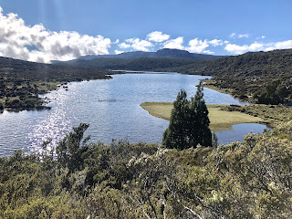
The wind came up so I walked on and then the sun came out for a while. Around the corner was postcard pretty Lake Lucy Long with pencil pines dotted around it
and soon I could see Lake Nameless which is a very large lake to have no name. I could also see Ironstone Hut above the lake, which I was aiming for.
The trail followed Nameless lake edge for 2 kms which was lovely (Cloister Lagoon track I am talking to you) although the hut never got any nearer. Just scrub and boulders and slight ups and downs.
When I got to the hut I was surprised to see several packs inside and within half an hour, while I was putting up my tent on the only flat rockless ground I could find, the five owners of the gear turned up. 9.9 kms
February 6. I had breakfast sitting by the water and cloud came in but lifted by the time I headed off. With a blue sky and sunshine the views were even improved on yesterday. The lakes were bluer and the pencil pines a brighter green. I saw a wallaby and close to Lake Lucy Long I saw a snake by the trail. At Westons Lake I was hot and took off my beanie and down jacket. Then as I was climbing towards the highest point on the plateau I could see cloud coming in from the direction I was headed and very soon all was cloaked in white; this lasted all the way to Lady Lake Hut and I sat for an hour on the porch until the cloud lifted. Then I had a brief look at the small round lake and walked back down the long steep hill in the forest. 10 kms
No comments:
Post a Comment