
I had barely heard of Lake Rhona but when I saw it on the Taspaws list of walks requiring a permit I immediately booked a campsite, guessing it must be good. I had difficulty finding the lake on the map; it’s on its own in the southwest Franklin/Gordon wild rivers wilderness. So, after an enjoyable day at Mt Field with Annette and Ian, I was off somewhere new.
February 8. I set out in forest and soon came to the Gordon River which I had to cross using a pair of huge logs as a bridge; I walked nervously along the first log and then sat down to shuffle along the second log. Then I recalled some instructions about crossing 40 metres upstream from here. The trail was still in forest and regenerating from the 2019 fires with dense ferns and grass trees. After a couple of kms I came out onto yellow button grass moorland with a fabulous vista of the Denison range on my left, a line of high craggy mountains not at all far away and stretching out of sight. Again this was a remote place and very beautiful. The trail returned briefly into the forest and the site of a former dwelling, Gordonvale. The trail crossed the moorland for a long time and there was evidence of the fires in pockets but the trees were no longer black. It had been very hot and sunny but there was a cooling wind and by late morning it was starting to cloud over. I sat by a creek for a break and met several groups of (returning) hikers to chat with, all of whom said the climb was hard but worth it. After 12.5 kms I commenced climbing up onto the range. It was pretty steep at first and eased off, up grassy hillsides with many granite boulders. There was still burnt vegetation but some wildflowers were appearing including lots of pink boronia. I had no idea what lay in store. Almost suddenly, starting to descend a ridge, I rounded a bend and saw the lake: it was quite an astounding sight, a round black lake in a bowl formed by steep sided rock and Mt Reed the dominant peak.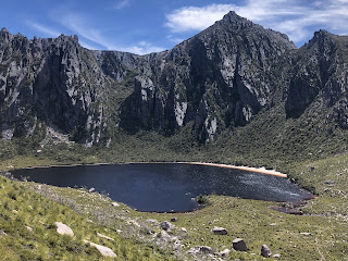
What stands this lake apart from the multitude of alpine lakes I have visited is the 300 metre long, white sandy beach. Walkers camp on this beach. There were six tents there when I arrived, but there was masses of space on the beach. It could have been a tropical island. I was greeted by an array of flowering bushes I had not seen before like white flowering orites, mountain geebung and rigid heath, and a small King Billy pine right where I put my tent.
What stands this lake apart from the multitude of alpine lakes I have visited is the 300 metre long, white sandy beach. Walkers camp on this beach. There were six tents there when I arrived, but there was masses of space on the beach. It could have been a tropical island. I was greeted by an array of flowering bushes I had not seen before like white flowering orites, mountain geebung and rigid heath, and a small King Billy pine right where I put my tent.
I waited for the sun to be properly out before going for a swim; the water was cold and I needed to be able to warm up afterwards. I didn’t stay in long but it was very nice. Then I just sat on the beach as if I were on holiday. 15 kms
February 9. Breakfast in bed on the beach today, after viewing the sunrise and how the sun lit up the rock. 
The water was still enough to reflect the peaks for only a few minutes before the surface became rippled. I waited until it was warmer and started on my hike up Reeds Peak which towers over the lake. There was a trail heading straight up from the campsite and a sign saying it was closed, but the sign looked old and I had seen people using it so I used it too. I kept losing the path but basically I scrambled steeply upwards over grasses, scoparia, dead branches and big rocks. I ended up on a real track and came to another lake in a cirque.
I climbed so much I expected to pop out on top of the mountain but I had a long way to go. I followed a grassy ridge then crossed a saddle perched on a knife edge then negotiated some tricky rocks and I still wasn’t there. I had to take a trail around to the other side of the mountain to access the summit track. The panoramic views were already stunning. I worked my way to the summit with lots of scrambling and I couldn’t tell if I was on the trail, and several times I thought I must be at the top but I couldn’t see Lake Rhona. When I finally got my lake view it was amazing as the lake was a long long way below. Also I could see mountains forever.
Coming down wasn’t fun at first as I had no idea where to descend and it was by sheer luck that I found a quicker way down the top bit than I’d gone up. I joined the proper ascent/descent track (to make the walk into a circuit) and had an easy walk along the ridge behind the Great Dome with a view over what may have been Lake Gordon. There was a profusion of snow daisies and some weird rock formations. Quite low down I saw another lake with a tiny sand beach. At Lake Rhona only my tent and one other was left. I had already decided to start the return trip as the weather was deteriorating so I had lunch and packed up.
Walking back was no anticlimax; this would be a good hike even without the lake, for the mountains and vast button grass valley dissected by many creeks. I stopped to camp at Gordonvale by the rusty machinery - a lovely ferny enclave in the forest. The mozzies were diabolical. It started raining soon after I got into bed. 15 kms
February 10. Dead still morning following a wet night. I covered the last of the moorland and reached the Gordon River where I crossed in the correct place this time, wading shallow water. The water was really refreshing and this was so much more pleasant than the logs. But there the fun temporarily ended: I could see no sign of the trail on the other bank although it should have been right there. Then I noticed marker tape on a tree to my left (west) and following it I saw more so I thought I was ok. Unfortunately the route ended (after at least eight markers) in a mass of logs on the river bank and when I tried wading further west in the river I saw nothing useful. This didn’t make sense because I thought I was heading in the right direction, based on the relationship of my log crossing two days ago and the correct crossing point today, although I realise now I was wrong because I unwittingly photographed the logs I’d crossed on. 
In the midst of my confusion I was cheered up seeing two wallabies on the far bank. I returned to the first piece of tape and, frustratingly, there was tape on another tree standing to the east. This marker led me to the proper trail. Fifteen minutes later by chance I met two park rangers coming towards me.
In the midst of my confusion I was cheered up seeing two wallabies on the far bank. I returned to the first piece of tape and, frustratingly, there was tape on another tree standing to the east. This marker led me to the proper trail. Fifteen minutes later by chance I met two park rangers coming towards me.
After this adventure I had a humdrum stroll back uphill to my car. 6 kms
In the next two days I walked up a couple of peaks in the southwest, two of Tyrone’s walks. First I went up Hartz Peak on a gloomy day. The path had a lot of boardwalk across moorland passing small lakes and then ascended in tea tree. There was a scramble over scree and a short ridge walk to a summit that was a jumble of rocks. The best view was down over Hartz Lake. There were mountains all around but hazy with the higher peaks of the southwest in cloud. 8 kms
The next day I climbed Adamsons Peak which is a conical peak standing out on its own behind Dover. The climb began in forest, everything covered in moss. There were lots of logs to walk along on top, logs to step over, logs to creep under and logs beside the trail. 
At the top of the forest I had a view over the Esperance inlet and the logging road I had driven. There, on the edge of the plateau, I met a group of walkers at a junction and we disagreed about which way to go; I went my way and after a km I bashed across to their path, and I think mine was the old track. Then followed a very wet section of trail with soft mud and pools and I was able to test out my new waterproof boots (successfully). I had to push through plenty of dense head high tea tree. Ahead was a summit I had to get over in front of the main summit.
The climb was on big rocks which was fun and then I followed a grassy ridge towards the real summit which was all large rocks. The route was cairned and I couldn’t see the summit cairn until I was just about there; it was a huge wall of rock chips. The views were great in all directions, over the mountains, down big river inlets and along the coast. It was windy so I descended a bit before eating my cheese sandwiches. On the return I managed to go around the minor peak rather than over it, and I took the trail favoured by the other walkers, which led past a few tarns and a hut ruin (the hut was still intact in Tyrone’s account). It seemed easier bashing through the tea tree and skirting the worst puddles on the way down. The forest descent fell really long but it was totally quiet and very peaceful. I saw a snake beside the track and heard wallabies. Something strange happened at the bottom: I didn’t notice either the boot cleaning station or the registration book that I had passed on the way up, and when I got to the car I went back to check and still couldn’t find them. I must have made a small detour since the boot cleaning station always occupies the full width of the trail. Hartz Peak (1259 m) was higher than Adamsons (1229 m) but today’s climb was much longer and harder. 15 kms
No comments:
Post a Comment