27 February 2022

Hikes from Narcissus Hut


I wanted to have a better look at some of the attractions accessed from the southern part of the Overland Track and my first objective was Lake Petrarch.

February 23. I took the tiny little ferry across Lake St Clair to Narcissus hut, after a mad run back to my car to get my hiking poles I’d forgotten, realising this just as the boat was about to depart. I ate lunch at the hut then walked to the Cuvier Valley track turnoff. There were signs warning that the trail is not maintained but I was pleased to find that it appeared well used and was marked with arrows and tape. I only had to backtrack occasionally. I climbed in myrtle beech forest for about two hours and then tall scrub and snow gums until I reached Byron Gap, a saddle below Mt Byron.

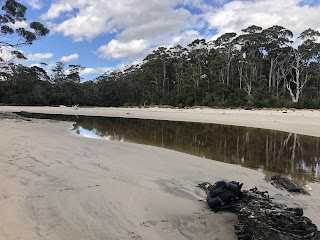
Then followed a big descent to terrain that would usually be boggy but only had small patches of mud, with button grass, reeds and tea tree surrounding Lake Petrarch. It was harder to stay on the track but once I got a glimpse of the lake I just aimed for it. I arrived at an open grassy area below Mt Olympus, left my gear and walked up the side of the lake until I ran out of dry shore. There were beautiful pines along the lake and nice views of the mountains all around,


and lots of pandanus dotted about like sentries. At the far end of the lake was a sandy beach. I could have continued there to camp but after my recent experience I am off sand. The grassy area where I decided to camp was full of wombat holes so I was hopeful of finally seeing a wombat. But no luck. 9.6 kms

February 24. The morning was clear when I got up but by breakfast I was completely socked in. I found the way back across the dry bog and into the forest. I enjoyed the dense tall pandanus section,

and didn’t have much problem with following the trail. At Byron Gap Mt Byron was invisible but the Du Cane range to the north was spectacular set against a blue sky. In the course of the descent I went off piste and found a lovely trickling waterfall where the rocks and broken branches were all mossy. But I was glad to finish with the forest as I found the constant search for markers to be stressful.

After a long break at Narcissus hut I walked to Pine Valley. The path was at first along the Narcissus River, then Cephissus Creek which required crossing on suspension bridges. Two were nice and wide while the third was the dangerous sort. It had become very hot; fortunately the trail went into forest which was noticeably cooler. I was quite tired and keen to reach the hut/campsite; when I got there it was busy and there weren’t many places to camp and luckily I found a one-tent patch in the forest across the trail from Cephissus Creek. In the evening wallabies came out. 18 kms

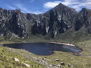
February 25. There was a pair of green parrots busy in the tree above my tent. I set out on a day walk to the Labyrinth, at first in beech forest then more open with scrub, pandanus, snow gums. At a junction I turned for Lake Elysia, passing Lake Cyane, walking the length of Lake Ophion. All were shining blue lakes in the sunshine. Lake Elysia is apparently famous for its reflections but it was unfortunately slightly breezy today so the surface was rippled and not making good reflections. The sight of The Acropolis and Mt Geryon behind the lake was nevertheless extremely impressive.


I saw a good reflection of Walled Mountain in an adjacent tarn.

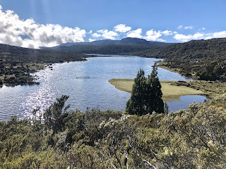
I walked to the opposite shore of Lake Elysia for views of Mt Gould.

Then I returned to the junction and climbed to the Labyrinth lookout and enjoyed all these mountains and lakes again plus more and a part of Lake St Clair.


It was almost mesmerising and I leant against the summit cairn rocks staring. The return to the hut felt steeper than the walk up. I decided to stay another night and camped near the hut. There was hardly anyone there; a couple who arrived said they had seen my car at Cockle Creek and been surprised to see the same car again at Cynthia Bay. 11 kms

February 26. Wet night and overcast morning but soon sunny. I went to look at Cephissus Falls in a mossy enclave in the forest, several trickles falling into a deep black pool.

Then I walked back to Narcissus wishing I’d done more in the Labyrinth but at the same time feeling tired. Once I was out of the forest I had great mountain views and the golden button grass.

(About my only memory of our 1986 camping at Narcissus is of the golden colour of the landscape.) I stopped just short of the hut and clambered down to the river and sat there for two hours with a view of Mt Olympus.

At the hut I hung around waiting for the ferry and we saw a large platypus swim down the river. 9 kms


22 February 2022

South Coast Track, Tasmania


After my brief foray onto the South Coast Track last April I had not expected to return and do the full hike. I think it was falling over in South Cape Rivulet and then all the mud that put me off. but thanks to Annette and Ian's kindness in enabling me to leave my car at the track finish I was able to make another attempt, and this turned out to be a wonderful hike.

 February 16. The flight from Hobart to Melaleuca (six passengers in an eight seater) was spectacular, seemingly passing over the mountains at the same altitude I would be at when I stand on top, and I recognised both Hartz Peak and Adamsons. The airstrip was a patch of sandy ground in a button grass valley and I did not linger as I felt four days of relative inactivity was quite enough, and it was already mid afternoon.

The trail crossed the valley, often on boards and with the strong crosswind some of this walking felt like a balancing act; I was glad when the wind swung around to become a tailwind. I saw masses of fairies aprons. After a while the trail was alongside the.New Harbour range and passed Freney Lagoon. Then fairly suddenly I heard a loud din and I was at the beach. I had arrived at the real start of the hike. It was a wide beach with mountains looming above and backed by chalky stones and scrub.

As I walked the beach I could see high Eric Bluff behind and Pt Eric ahead. Gulls and oystercatchers. The path crossed Point Eric inland, lovely sassafras in the forest, and emerged at a large campsite by the beach on the far side. This was me for the night, and it started to rain lightly. 13 kms

February 17. It was a noisy night with wind, rain and surf but quite well moonlit and I looked out at my sea view often. The morning started with a beach walk (at high tide) then crossed a bluff, another beach and a climb through a button grass valley onto the Red Points range; it was windy on the way up and completely still on the other side. The views towards the Ironbound range were great and the valleys were pretty in their yellows and greens with a variety of white-flowering bushes.

I paddled through a couple of creeks in my waterproof boots. So far they really are waterproof. The path was often white stones and I could see it stretching ahead over the hills. I dumped my pack and made the detour to Louisa Bay which had a lovely beach and islands, interesting bushy formations and was sunny so I lounged on the dunes.

Heading back it was really windy and stayed like that to Louisa River. I had to cross this river and it was one I had worried about but it was shallow and no problem. As I arrived at the campsite the first thing I saw was a spotted tailed quoll. I chose a nice spot by the river. 23 kms

February 18. This was a hard day. As I packed up during a break in the rain I heard two thunderclaps but nothing more. I started with the long climb from the river (the water level was noticeably higher after a night of rain) up onto the Ironbounds. It was raining and this soon turned to sleet. Then the rain died away and the surrounding mountains were visible with their peaks in cloud, very atmospheric and remote. I got glimpses of the coastline north. The trail was a mixture of boardwalk, steps and rough path, mostly not too steep. After a bit there was hail. The wind was roaring away and in unsheltered stretches it was so strong it was hard to stand. Near the top I could see the coastline in both directions, very indented with a fringe of white surf. I didn’t actually realise when I had reached the top until I noticed I had started descending. The descent began innocuously enough with boardwalk and newish steps.

 Once I was into the rainforest things changed completely: the trail became a series of waterfalls interspersed with patches of mud, big steps to negotiate, tree roots to balance on or step over, branches to pass under and all on steep terrain. It was extremely slow going. My boots ceased to be dry after stepping through so many shin deep pools. The weather would look as though it was improving and then the rain would return. I crossed a couple of waterfalls with no problem. Then after hours of this I started to hear a loud noise that could have been the wind or even the surf - I expected to reach the coast at some point - but I rounded a bend to see a thundering creek, more like a waterfall, flowing turbulently over smooth rock with no obvious way across. I had no idea what to do, then I noticed some big branches hanging across the rock and I bashed my way up to them through dense ferns and crossed hanging onto them. That was enough scary stuff for one day. I trundled on, crossing several more creeks and was delighted when the trail became a lot smoother and I had a view of a rocky bay through a gap in the trees. It seemed far below but the descent was imperceptible and I was soon at Little Deadmans Bay campsite.

A pink-breasted robin was flitting about. It was sunny but then the rain came, then it cleared, then it rained. The bay had a pebbly beach and islands offshore. In the evening a spotted tailed quoll came and lurked around the tents, and it was a nuisance in the night. 14 kms

February 19. I woke to a beautiful sunny day and had breakfast on the beach. It was a perfect temperature for hiking and I walked with Jason over a bluff, along Turua Beach, more forest and out onto Prion Beach for 4 kms of firm sand.

I was definitely not excited about the next bit. We got to New River lagoon - behind the lagoon were great views of Precipitous Bluff and other peaks - and located just one rowboat on our side, which meant we would have to cross three times.

Luckily for me Jason had done this before. The first crossing was the worst as for a long time it didn’t seem like we were moving, and the wind and current were a nuisance, but by the third trip we went better. I could never have done this alone. Sitting in the rowboat in the middle of the lagoon it seemed enormous. We walked on in the forest to the next creek, above the river with views over it.

The creek had an unusually elaborate bridge, and we had lunch there (watched a spotted tailed quoll run over the bridge), then walked through more forest with window views over the coast, and across one of the lovely valleys to Osmiridium beach campsite. We saw two snakes, one of which didn’t want to leave the path. The campsite was among the trees but the nearby ocean was loud. This was another beautiful beach. 16 kms

February 20. There were little brown rails wandering around the campsite and honeyeaters chirping. I set out with the sky full of black clouds, but as I walked to Surprise Bay the sun was trying to come out. I saw a wallaby. The trail went into forest with amazingly huge girthed trees and blechnum (ferns). I came onto Surprise Beach - there were cockatoos in the trees by the beach and I saw a solitary hooded plover - walked along the sand and waded the shallow rivulet to the steps leading up from the beach.

These steps were the furthest point of my hike here last year. The conditions were rather different today: still and warm. The climb from Surprise Bay was steep and led to a good view over the bay.

The trail then followed a sort of ledge on the hillside and became quite faint; at this point I realised I wasn’t on the trail any more and I had to bush bash back to it, cutting my arms badly on the prolific cutting grass. When I reached Granite Bay I had a nice surprise: there was plenty of sand to walk on almost the whole stretch of beach and I only had a little boulder hopping. The creek at the far end was easy to cross. I sat and had a snack above the beach then headed off towards the mud. 

The climb off the beach was long and looking back I got fantastic views over the morning’s beaches and all the islands off shore.

On some of the boggy bits there were dozens of fairies aprons.

Soon I was starting on the mud; at least this time I was prepared for it so it wasn’t the bad shock it had been in April. I took it steadily and rarely went in the mud up to my gaiters. I don’t think it was as bad as last time but it seemed to go on for longer. (In general things were drier than last time and the creek I had slept near was completely dry.) Although I was deep in the forest I could tell the sun was shining. I loved the total silence in the forest. Quite suddenly, four hours after leaving Granite, I popped out of the forest onto boardwalk among tea tree and a bush I’ve been seeing everywhere. This was a great relief. I still had several hills to climb in drier forest (lovely banksias) and I was tired, but it was good to have the hard parts of the hike over. It was several more kms to South Cape Rivulet and I had no choice but to continue as there was no water available until there. With great delight I eventually heard the sound of the surf and then I was at the beach. The part of the rivulet that has to be crossed had a tiny amount of water compared to April, shin deep, only a few paces and calm (as it was low tide).

I waded across to the campsite and took a spot on the beach. The sky was blue and all looked idyllic, then within an hour it was pouring. This was not the best time to discover that I had left my tent pegs behind this morning. I improvised, but camping on sand is risky at the best of times and I couldn’t find any rocks for stability. It should have been a miserable night: my tent collapsed repeatedly and it leaked under the fly so my sleeping bag was soaked. I put on my rain gear, got into the sleeping bag and slept well, after realising I would have to sleep with the tent held up by just one pole. It rained heavily off and on with a strong wind. Since I had to go outside several times in the night to adjust the tent and I was camped on sand that became wet, I brought a lot of wet sand into the tent and into my sleeping bag. Dinner was the packet of Oreos that I had brought as my reward for having a good attitude towards the mud; they weren’t meant to replace dinner but it was too hard to even prepare cold food in a collapsed wet tent. 18 kms 

February 21. When the rain stopped briefly I packed up and left. It soon started again as I went through more forest, came to a cute little beach, more forest then a longer beach leading to Coal Bluff. The ocean facing viewpoints in the bush showed a view of nothing much due to the rain. It was incredibly windy and I didn’t like the idea of the cliff edge walk along the bluff but it was ok, blowing onshore, and the view towards South Cape was good. The sun would come out and next minute it was raining heavily. One time it hailed. I stopped by a creek in the forest for a very late breakfast of coffee and Nutella wraps with sand as everything in my pack was sandy. I saw a lyrebird. The last few kms were unremarkable apart from the weather changing so often. My car was almost alone in the large car park although I had taken the last space when I dropped it off. 12 kms

Lake Rhona and some mountains


had barely heard of Lake Rhona but when I saw it on the Taspaws list of walks requiring a permit I immediately booked a campsite, guessing it must be good. I had difficulty finding the lake on the map; it’s on its own in the southwest Franklin/Gordon wild rivers wilderness. So, after an enjoyable day at Mt Field with Annette and Ian, I was off somewhere new.

February 8. I set out in forest and soon came to the Gordon River which I had to cross using a pair of huge logs as a bridge; I walked nervously along the first log and then sat down to shuffle along the second log. Then I recalled some instructions about crossing 40 metres upstream from here. The trail was still in forest and regenerating from the 2019 fires with dense ferns and grass trees. After a couple of kms I came out onto yellow button grass moorland with a fabulous vista of the Denison range on my left, a line of high craggy mountains not at all far away and stretching out of sight. Again this was a remote place and very beautiful. The trail returned briefly into the forest and the site of a former dwelling, Gordonvale. The trail crossed the moorland for a long time and there was evidence of the fires in pockets but the trees were no longer black. It had been very hot and sunny but there was a cooling wind and by late morning it was starting to cloud over. I sat by a creek for a break and met several groups of (returning) hikers to chat with, all of whom said the climb was hard but worth it. After 12.5 kms I commenced climbing up onto the range. It was pretty steep at first and eased off, up grassy hillsides with many granite boulders. There was still burnt vegetation but some wildflowers were appearing including lots of pink boronia. I had no idea what lay in store. Almost suddenly, starting to descend a ridge, I rounded a bend and saw the lake: it was quite an astounding sight, a round black lake in a bowl formed by steep sided rock and Mt Reed the dominant peak.

What stands this lake apart from the multitude of alpine lakes I have visited is the 300 metre long, white sandy beach. Walkers camp on this beach. There were six tents there when I arrived, but there was masses of space on the beach. It could have been a tropical island. I was greeted by an array of flowering bushes I had not seen before like white flowering orites, mountain geebung and rigid heath, and a small King Billy pine right where I put my tent.

I waited for the sun to be properly out before going for a swim; the water was cold and I needed to be able to warm up afterwards. I didn’t stay in long but it was very nice. Then I just sat on the beach as if I were on holiday. 15 kms

February 9. Breakfast in bed on the beach today, after viewing the sunrise and how the sun lit up the rock.

The water was still enough to reflect the peaks for only a few minutes before the surface became rippled. I waited until it was warmer and started on my hike up Reeds Peak which towers over the lake. There was a trail heading straight up from the campsite and a sign saying it was closed, but the sign looked old and I had seen people using it so I used it too. I kept losing the path but basically I scrambled steeply upwards over grasses, scoparia, dead branches and big rocks. I ended up on a real track and came to another lake in a cirque.

I climbed so much I expected to pop out on top of the mountain but I had a long way to go. I followed a grassy ridge then crossed a saddle perched on a knife edge then negotiated some tricky rocks and I still wasn’t there. I had to take a trail around to the other side of the mountain to access the summit track. The panoramic views were already stunning. I worked my way to the summit with lots of scrambling and I couldn’t tell if I was on the trail, and several times I thought I must be at the top but I couldn’t see Lake Rhona. When I finally got my lake view it was amazing as the lake was a long long way below. Also I could see mountains forever. 


Coming down wasn’t fun at first as I had no idea where to descend and it was by sheer luck that I found a quicker way down the top bit than I’d gone up. I joined the proper ascent/descent track (to make the walk into a circuit) and had an easy walk along the ridge behind the Great Dome with a view over what may have been Lake Gordon. There was a profusion of snow daisies and some weird rock formations. Quite low down I saw another lake with a tiny sand beach. At Lake Rhona only my tent and one other was left. I had already decided to start the return trip as the weather was deteriorating so I had lunch and packed up.

Walking back was no anticlimax; this would be a good hike even without the lake, for the mountains and vast button grass valley dissected by many creeks. I stopped to camp at Gordonvale by the rusty machinery - a lovely ferny enclave in the forest. The mozzies were diabolical. It started raining soon after I got into bed. 15 kms 

February 10. Dead still morning following a wet night. I covered the last of the moorland and reached the Gordon River where I crossed in the correct place this time, wading shallow water. The water was really refreshing and this was so much more pleasant than the logs. But there the fun temporarily ended: I could see no sign of the trail on the other bank although it should have been right there. Then I noticed marker tape on a tree to my left (west) and following it I saw more so I thought I was ok. Unfortunately the route ended (after at least eight markers) in a mass of logs on the river bank and when I tried wading further west in the river I saw nothing useful. This didn’t make sense because I thought I was heading in the right direction, based on the relationship of my log crossing two days ago and the correct crossing point today, although I realise now I was wrong because I unwittingly photographed the logs I’d crossed on.

In the midst of my confusion I was cheered up seeing two wallabies on the far bank. I returned to the first piece of tape and, frustratingly, there was tape on another tree standing to the east. This marker led me to the proper trail. Fifteen minutes later by chance I met two park rangers coming towards me.

After this adventure I had a humdrum stroll back uphill to my car. 6 kms 

In the next two days I walked up a couple of peaks in the southwest, two of Tyrone’s walks. First I went up Hartz Peak on a gloomy day. The path had a lot of boardwalk across moorland passing small lakes and then ascended in tea tree. There was a scramble over scree and a short ridge walk to a summit that was a jumble of rocks. The best view was down over Hartz Lake. There were mountains all around but hazy with the higher peaks of the southwest in cloud. 8 kms

The next day I climbed Adamsons Peak which is a conical peak standing out on its own behind Dover. The climb began in forest, everything covered in moss. There were lots of logs to walk along on top, logs to step over, logs to creep under and logs beside the trail.

At the top of the forest I had a view over the Esperance inlet and the logging road I had driven. There, on the edge of the plateau, I met a group of walkers at a junction and we disagreed about which way to go; I went my way and after a km I bashed across to their path, and I think mine was the old track. Then followed a very wet section of trail with soft mud and pools and I was able to test out my new waterproof boots (successfully). I had to push through plenty of dense head high tea tree. Ahead was a summit I had to get over in front of the main summit.

The climb was on big rocks which was fun and then I followed a grassy ridge towards the real summit which was all large rocks. The route was cairned and I couldn’t see the summit cairn until I was just about there; it was a huge wall of rock chips. The views were great in all directions, over the mountains, down big river inlets and along the coast. It was windy so I descended a bit before eating my cheese sandwiches. On the return I managed to go around the minor peak rather than over it, and I took the trail favoured by the other walkers, which led past a few tarns and a hut ruin (the hut was still intact in Tyrone’s account). It seemed easier bashing through the tea tree and skirting the worst puddles on the way down. The forest descent fell really long but it was totally quiet and very peaceful. I saw a snake beside the track and heard wallabies. Something strange happened at the bottom: I didn’t notice either the boot cleaning station or the registration book that I had passed on the way up, and when I got to the car I went back to check and still couldn’t find them. I must have made a small detour since the boot cleaning station always occupies the full width of the trail. Hartz Peak (1259 m) was higher than Adamsons (1229 m) but today’s climb was much longer and harder. 15 kms 

Western highlands, Tasmania


January 29 I found myself driving along the road the Penguin Cradle track crosses at the Vale of Belvoir and I could not resist climbing Mt Beecroft which I had regretted not climbing when I did the trail exactly a year ago. It’s a very imposing mountain and the summit is only a km off the PCT.

The views were clearer today than they would have been last time. This was a nice section of the trail so I didn’t mind repeating 4 kms each way, on button grass and flowering tea tree hillsides with views to Cradle-Barn, Pencil Pine Creek and the Black Bluff range. The sun came out from time to time.

From the summit turn off the path was well marked with poles and soon climbed steeply to the summit plateau. The plateau was scenic with clumps of big granite slabs scattered about and whoever had built this mountain had used a collection of these slabs to make the summit that little bit higher and tricky to reach. I made it, though, but did not linger because of large numbers of wasps and flies. As on every other day they were a pest whenever I stopped moving. 11 kms

January 30. I intended to do a 2 day loop in the Walls of Jerusalem NP with an overnight at Junction Lake. Mersey Forest Rd was so rough I couldn’t get my car to the end so I altered my route, which meant the walk on day two would be different and I had to walk six kms of gravel road to reach the start today. I only set out at 12.30.

After the road walk I went into forest and soon came to the Mersey River and another of those nasty suspension bridges, except this one didn’t even have chicken wire at the sides. The early part of this Moses Creek track was in regenerating forest filled with ferns and the trail had recently been tidied. But soon I was in old growth forest and climbing. I had been pleased to see several cars in the car park (the one I couldn’t get to) because this meant there would be people about on the trail, but I bumped into all of them returning in my first two kms. It was nice to chat but after that I was alone.

I walked alongside Chapter Lake (rather oddly it looked white to me from reflecting the sky) to make a small detour to see the top of Grail Falls. And then the trail quickly showed its true colours. It became a narrow path through scrub, often scratchy. It was really slow going. I have never seen so many lizards (skinks). For a wonderful few minutes I emerged into a green valley of coral fern ground cover and granite outcrops before returning to the scrub. I got quite excited when I came to Cloister Lagoon after 7 kms of scrub and I had a short break there by the water

but after that the trail followed the lake out of sight of the water until the bottom end an hour later. There was another open valley beyond the lake and next more forest. It wasn’t difficult just slow and the trail was the most twisty I’ve ever seen. I saw plenty of footprints in places that must have usually been muddy so I knew people came here, just not today. Finally I came out onto the boggy/ferny grassland that would lead to Junction Lake; the lake was a bit elusive but at 7 pm I saw an obvious clearing for camping (even before I saw the lake) and felt very relieved. The lake was beautiful with high peaks around it and completely calm. I enjoyed a lovely still evening, just the occasional bird call, but the dreadful mozzies sent me into my tent straight after dinner. 18 kms

January 31. It was misty all around when I got up but that soon morphed into a blue sky day. Hot. I set out to follow the trail to Lake Meston and almost immediately went the wrong way. (In doing so I completely missed seeing Junction Hut, which puzzles me still.) This was to be the story of the next few hours: following a clear trail and suddenly realising I was no longer on it, and I could never work out what had happened. One time as I battled scoparia after going off piste I saw a snake scuttling away. I got to see pretty Lake Youd which was well off the trail.

The constant discovery that I wasn’t where I should be got me a bit spooked. (I always found the trail again fairly soon.) After about two hours of this I got on the trail and stayed on it for a long time with window views over Lake Meston. When I reached Lake Meston hut I saw I had walked just 5.4 kms in three hours (without stops). 

From here I was doing a walk I did two years ago in the opposite direction. I went mainly through bush, quite overgrown and scratchy, to Lake Myrtle, lovely setting beneath the dramatic cliffs of Mt Rogoona (which I mistakenly walked towards for a bit). I had a problem finding the river crossing here last time so to save myself the issue again I bush bashed from the plains by the lake, crossing at a random place and successfully reaching the path. Then I stopped by the river to collect water and as I did this I heard a rustling noise: an echidna was doing its thing right there. 

On I went to Lake Bill, sometimes in bush and then extensive lake flats with great views of the lake. There has been fire here many years ago and it seems that now the dead trees are falling down so when I went into the forest there was debris blocking the way everywhere which made walking slow, although the absence of foliage allowed views of the high cliffs around the forest. There was a lot of just one plant species, in profusion: white waratah. I was keen to start the long descent to the road as I was worn out and the descent would signal I was almost done, but I also dreaded it because I knew how steep it was having walked up last time. In the end it wasn’t too bad. From the bottom I had two kms of road back to my car and when I got there I thought I might have walked too far for comfort today. As I drove along an eagle flew close to the car. 19 kms,

February 2. My next project: walk the Arm River track to Pelion Hut on the Overland Track, do a side trip and go back. The temperature at the trail head was seven degrees which was a terrible shock after all the hot weather. I set off in my down jacket. I soon warmed up on the climb and it was nice walking in bush to Lake Price, where there was a great view of Mt Pillinger with the lake in the foreground.

Too cold to sit. Then a brief valley where I had fantastic mountain view (Cathedral?). At the next opening the peaks were in cloud. I came out onto open plains by the Wurragurra River and wanted to stop for coffee but the cold wind put me off that idea. I saw a snake slithering off the boardwalk. I continued into forest, moss covered tree trunks and the ground thick with fagus leaves; also a lot of celery-top pines which is a very weird looking tree. It was warmer there so I had a break sitting on one of the giant logs. Out in the open I walked towards a forested mountain and then had first sighting of Mt Oakleigh behind Lake Ayr,

and then more mountains. My rain jacket was on, off, on again with the intermittent light rain. The trail was really dry and mostly I ignored the bridges; there was extensive duck boarding and all the trail infrastructure made the trail feel less remote than it is. Quite a contrast to my previous hike. I came upon Pelion Hut quite suddenly and ate lunch on the veranda, Mt Oakleigh right in my face, then went inside to be warm. I camped with a great view and a lot of company, maybe 50 people. 12 kms

February 3. It rained most of the night and into the morning so I got up late but it still didn’t stop. I planned to climb Mt Oakleigh.

The clouds had been swirling around but the top of Oakleigh was always clear. Until I went out, when mist slowly enveloped the mountain. Never mind, the first part of the climb was in forest, nice and mossy with a stretch through a grove of pandanus. I saw a few wallabies. The path steepened and I met a guy descending who said he’d had reasonable views higher up. On the plateau the mist looked like it may clear and fairly soon I started having wonderful views. There were granite slabs everywhere which made for good viewpoints. I crossed a saddle and came to the edge of the plateau, right by the pinnacles that are such a feature of Oakleigh. I could see many more of these dolerite pinnacles rising sheer from the valley. The sun was shining most of the time I was up on top. I had excellent views of a great many peaks, all except Mt Ossa which had a big lump of cloud on top, the forested Forth River valley, the Cathedral range close to where I went on my previous hike, and many tarns and lakes. It was all the more magical for the constant changes due to the clouds moving. I even saw a rainbow hanging in the valley. The rain hadn’t gone and when it seemed to be returning seriously I walked back down but the sun came out again as I reached the hut. In the evening the sky cleared and I finally saw Mt Ossa. 10 kms

February 4. After a cold but clear night a perfect morning. I headed back along the Arm River track with the intention of doing the detour via Mt Pillinger. I recrossed the Pelion Plains, went into the forest and had great views from the duck board across the Wurragarra Plains. I saw an echidna. When I thought I was at the Pillinger turnoff I saw a scratchy track which I tried to follow but it became impassable and I turned back, giving up my hope of Pillinger. So I was delighted to see a clear track only metres further on and I followed this one easily across grassy bog and passing reedy lakes to the base of the summit track. I saw some purple fairies aprons on the bog. There a couple were about to start their climb and we had a long chat. 

The climb was unusual in that well over half was clambering over large rocks; it wasn’t difficult and it was fun although progress was slow. The track was well marked. Near the top rocky forest gave way to just rocks. The views from the top were some of the best I have ever had thanks to a wonderful clear day with barely a cloud. I could see my usual Cradle and Barn, Mt Ossa and the Pelions, Cathedral Mtn and mates, I could see down into Lees Paddock and in the distance (but still really distinct) the Mt Roland massif. I could see exactly where I had walked and the Wurragarra Valley filled with lakes.


On the way down I stopped for another chat with the couple. The remainder of the detour was mostly easy walking until the last part where the bushes were scratchy and the track was indistinct. I was glad to get back to the Arm River trail and start the zigzag descent to the car park. I had forgotten how long the climb was two days ago and the descent seemed endless. When I got down I made a cup of coffee and ate lunch at the trail head - it was 4.30 and I was extremely hungry - with everywhere being so dry I had not passed any flowing water to use for coffee. It was completely overcast by then. Now I have done the Arm River trail but I haven’t a clue where the Arm River is. 16 kms

February 5. I drove another sketchy road to the Higgs track trailhead and set out on a long steady uphill for over an hour in forest (520 m in 2.3 kms) with window views towards the top. The track crossed several gushing creeks and was ferny at the bottom, beech higher up. When I emerged from the forest I was on the Central Plateau with views over the farmland below and towards the Great Western Tiers and Ironstone Mountain. I could see Lady Lake and I walked over to the hut. The weather was overcast and looked like it could go either way. 

I headed for Westons lake across the plateau, climbing a little more to reach a huge expanse of low scrub (much of it flowering including mountain rocket, and even some of the nasty scoparia was in flower), bright green cushion plant, bog, rocks and boulders with low peaks dotted about on the horizon. I surprised a big kangaroo and then noticed a wallaby sitting watching me. I saw a few lakes and the whole area had a wonderful wilderness feel, with the comfort of a well cairned track (huge cairns enabled by so many rocks lying around I guess) and lots of footprints. Parts were quite muddy. I had lunch by Westons Lake and was surprised to see ducks on the lake. The March flies were bearable.

The wind came up so I walked on and then the sun came out for a while. Around the corner was postcard pretty Lake Lucy Long with pencil pines dotted around it

and soon I could see Lake Nameless which is a very large lake to have no name. I could also see Ironstone Hut above the lake, which I was aiming for.

The trail followed Nameless lake edge for 2 kms which was lovely (Cloister Lagoon track I am talking to you) although the hut never got any nearer. Just scrub and boulders and slight ups and downs.

When I got to the hut I was surprised to see several packs inside and within half an hour, while I was putting up my tent on the only flat rockless ground I could find, the five owners of the gear turned up. 9.9 kms

February 6. I had breakfast sitting by the water and cloud came in but lifted by the time I headed off. With a blue sky and sunshine the views were even improved on yesterday. The lakes were bluer and the pencil pines a brighter green. I saw a wallaby and close to Lake Lucy Long I saw a snake by the trail. At Westons Lake I was hot and took off my beanie and down jacket. Then as I was climbing towards the highest point on the plateau I could see cloud coming in from the direction I was headed and very soon all was cloaked in white; this lasted all the way to Lady Lake Hut and I sat for an hour on the porch until the cloud lifted. Then I had a brief look at the small round lake and walked back down the long steep hill in the forest. 10 kms