03 October 2022

Mont Ventoux

 I had seen Mont Ventoux so many times during my hike in the Luberon that it seemed necessary to climb it. I set out on the GR de Pays: Tour du Massif du Ventoux par le sommet, from Sault, a bus ride from Apt. The forecast for my summit day was not good.

26 September I started from the church in Sault, pleased to see plenty of eating options in the village for afterwards.

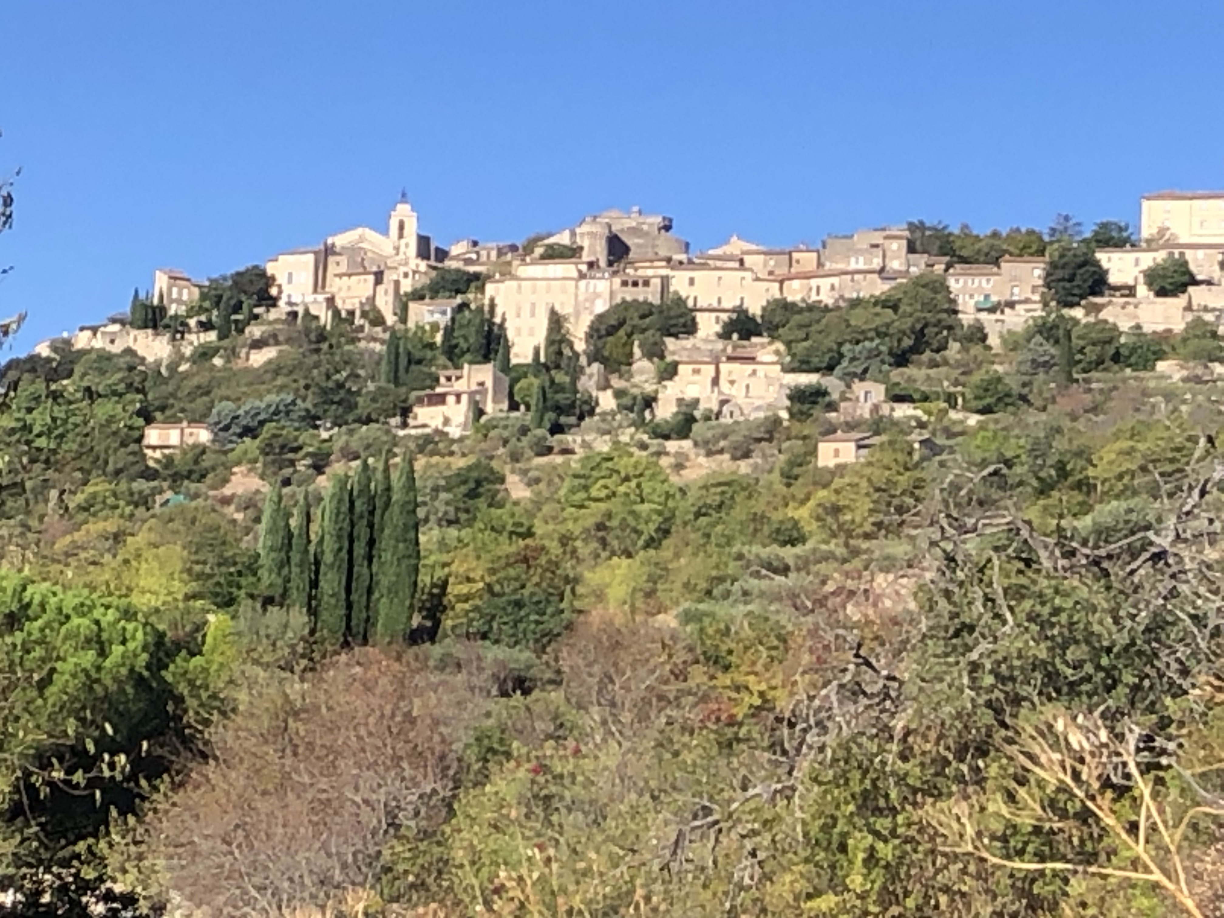
I could see Mont Ventoux very clearly, the same side I saw from the Luberon. The trail went into a puddly pine forest and I emerged at a pretty village, Aurel, with a church and castle ruins.

Then oak forest and I found myself among mountains with a quite different perspective on the Ventoux, seeing it from the east and as part of a mountain range for the first time. I had a little hill to get over on a rocky path and I arrived at Montbrun les Bains with a medieval core. I checked into the campground and had a stroll around, which involved a considerable climb to the church (nice frescoes), clock tower and castle ruins.

It was Monday but everything was open. 12 kms 

27 September I walked back through the town, had breakfast at the Tabac, and went through light forest to the edge of Savoillans. From there I started a reasonable climb onto a ridge north of the Ventoux massif but parallel, so I should have had a great view of the range; it was cloudy and I could see the whole Ventoux range bar the peak which remained obstinately covered. I could see Brantes sitting at the base of the mountains. As I began my descent to the village I bumped into two female hikers and we had a long chat. Afterwards I was delighted to be able to see, intermittently, the summit towers.

Brantes was a simple village not expecting many visitors; the only place open (and well hidden) did crêpes which suited me fine.

From right beneath it the Ventoux range looked formidable. When I left Brantes on its other side I realised it was a perched village and I still had a long descent to the valley.

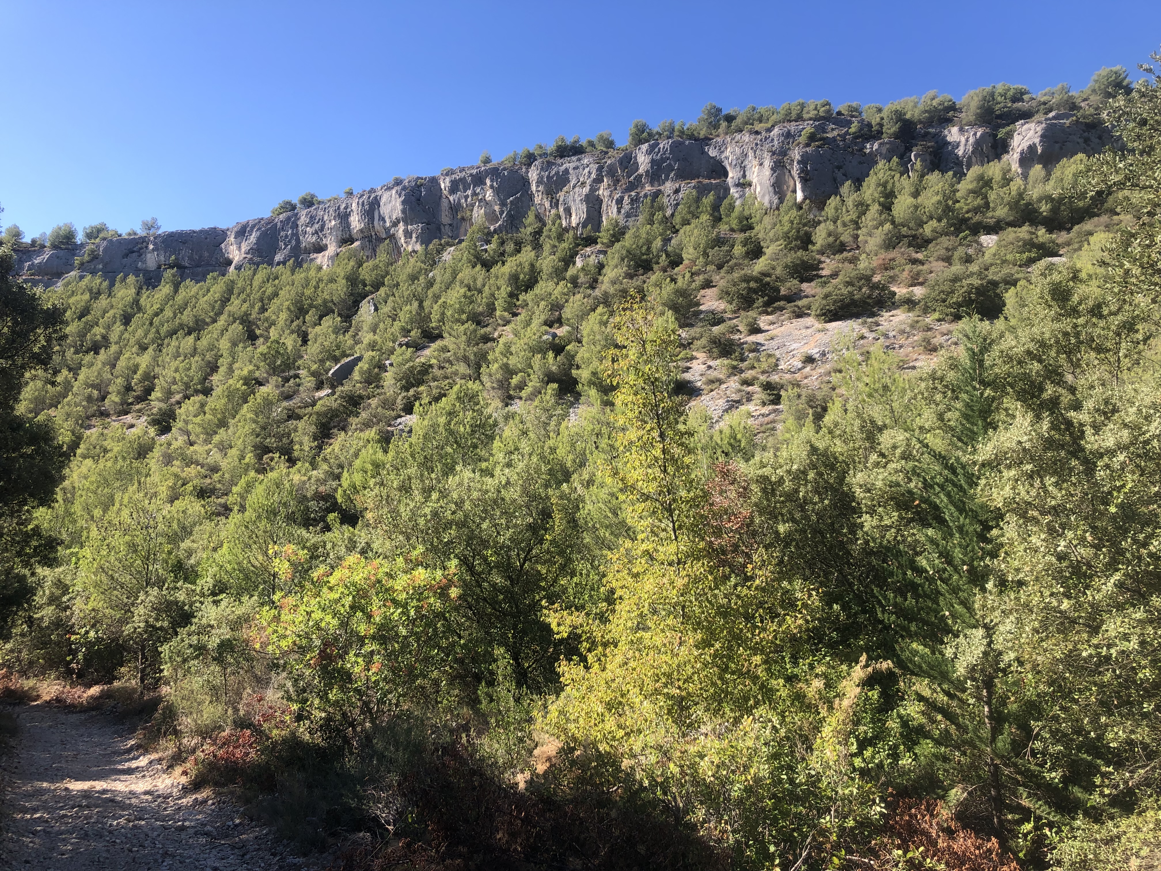
I crossed a dry river on an old stone bridge and the real ascent began. I was zigzagging in pine forest then came out onto a more open ridge with quite extensive mountain views south, although after over an hour I was only at 800 metres. It was very windy; the forest gave protection but I knew I couldn’t pitch my tent and I hoped the Contrat hut would materialise. I returned to denser pine forest and crossed several vast scree slopes, then came into patches of beech forest, although there was still pine forest on the higher parts. The gradient had eased. I saw a mouflon with big curled horns among the trees. I was happy to reach the hut (1400 m) and when I looked up: there was the summit directly above (500 metres higher).

The hut had mattresses. It soon became really cold and I got into my sleeping bag for warmth. 25 kms 

28 September The peak and plenty of forest below was in cloud when I woke up and I stayed in the warm for a long time hoping it would clear. When I left the hut the peak was still covered but there was plenty of blue sky. I continued in forest then came onto stony slopes, and the last part was hard on rough steep zigzags. I wore all my clothes and used my spare pair of socks as gloves, and I was comfortably warm despite the wind. At the top (1910 m) the cloud was solid and not going anywhere, but there were lots of people dropping in, cyclists and cars.

The summit kiosk was closed. I sat around waiting for the cloud to clear until I had enough of the wind, and started walking down.

The descent began on stony terrain with scattered dwarf conifers and I had a few views into the valley I left yesterday. I crossed a minor peak, Tête de la Grave. The path returned to forest and I could see a big black dome of cloud hanging over the higher ground while there was blue sky over the valleys. I went through sections of beech (it only grows at a narrow altitude range here) and into grassy woodland, lovely for camping if it weren’t so windy.

Jas Forest hut, my goal, was a pleasant surprise: I was worried about having very little water (I’d seen none since Brantes) and there was a well outside the hut; not seen that before. Inside I found some liquid hand sanitiser which burned nicely in my metho burner so I could make coffee with the sachets I’d been carrying for ages. 15 kms

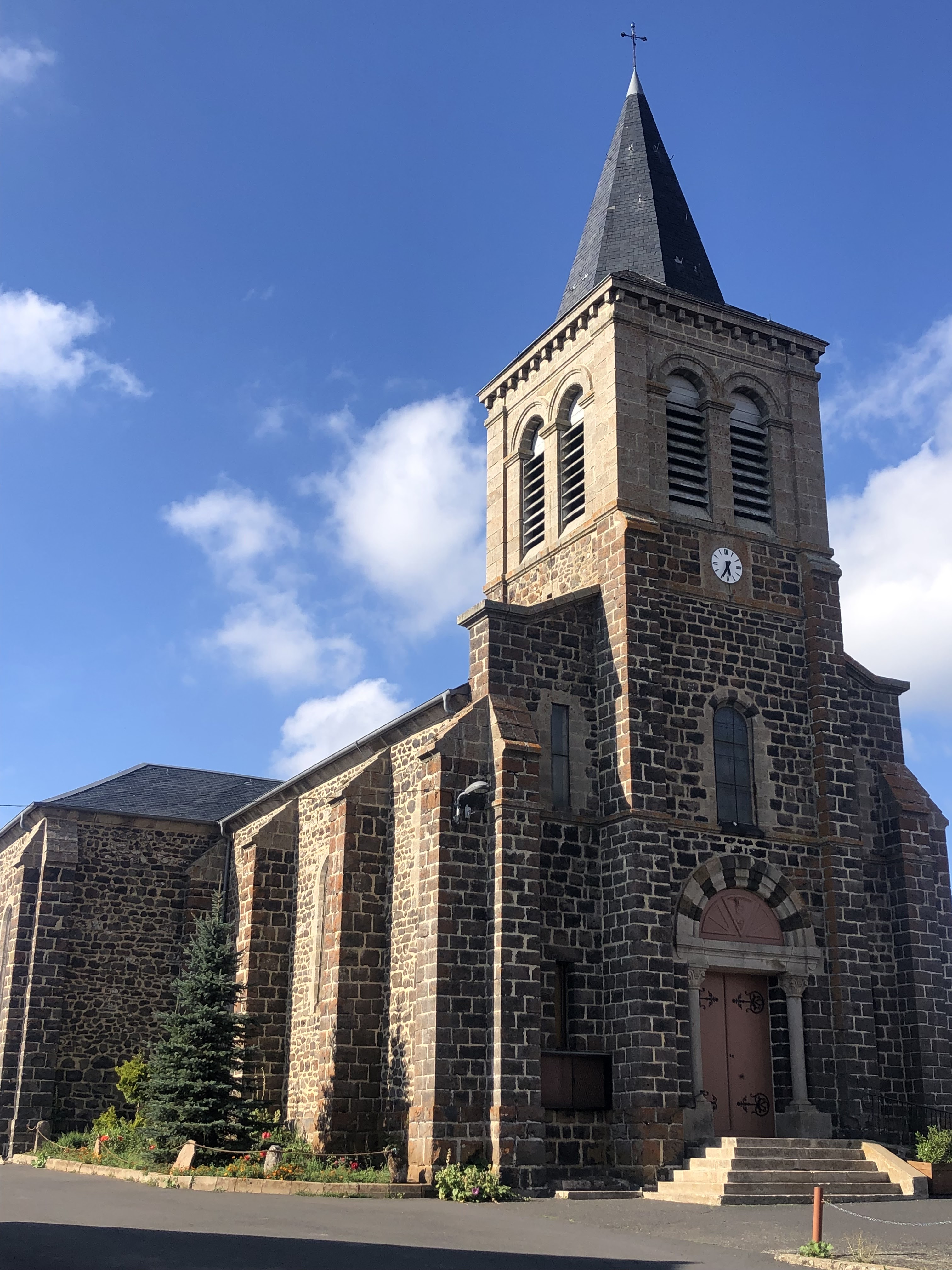
29 September I decided to make a change to the route by going to Monieux on the way to Sault so I wouldn’t have such a long wait for the bus. It was all downhill to Monieux, in forest, then I crossed a lavender field by mistake, then passing farmland and a steep descent into the village. Monieux had a 12th century church with a belltower, some remains of the surrounding wall, an original gateway and ruins high on a cliff above.

But no bakery. It was quiet apart from (surprisingly) a large group of walkers. I had coffee at a huge empty restaurant. 

The last section of my summer of walking in France was across farmland, sheep with barking patous, lavender. I had to climb to Sault and arrived back at the church (highest point in the town) after some cobbled laneways. I went for a crêpe (banana, nutella, chantilly) at the cafe that looked like it was a part of the church. Everyone seemed to be rugged up for winter; quite a contrast with my arrival in France. 14 kms

GR 97 - Grand Tour du Luberon

 In 2008 I ran a marathon in the Luberon and the area made quite an impression on me but the day was too hot for running. Afterwards I remembered virtually nothing apart from the start on a running track, a lake, drinking coke afterwards and my flight back to London. So I thought I should go back there. I discovered that the GR 97 does a big loop around the Luberon taking in villages, mountains and forest. I decided to start from Apt, known as Apta Julia in Roman times.

16 September I had a long bus ride to Apt and a search for sunblock before I could start out. The route was marked but the signs were faded and hard to spot. It was mostly road walking to hilltop Villars, where I joined the GR, views into Apt valley, vineyards, distant hills, and I stopped for coffee; the church was locked. 

Very soon I passed another elevated village with houses clustered around a church. I had an interlude along a ridge among pine trees and I had lunch with a nice view over the valley. I walked past a lot of vineyards and in oak forest and much of the trail changed to rocky tracks. The route was well waymarked for the rest of the hike. Late afternoon while walking through a vineyard I looked up and saw the pretty village of Roussillon on a hilltop close by.

I walked up to the village, which was very touristy but had interesting multicoloured cliffs and the houses were all pink, orange or yellow.

So I had a mango ice cream to match. I continued to the nearest campground (passing some interesting eroded sandstone formations) where the woman was amazed I had walked from Apt. I had a beer to celebrate. 25 kms 

17 September I had a windy walk cross country to Gordes through vineyards and ploughed fields. Quite early I could see the hilltop village (like Roussillon a plus beaux villages de France but I would call both towns); the buildings were stone coloured and merged into the landscape.

The final climb was steep, Gordes was at 350 metres, with a lovely view over the countryside. It was all quaint narrow streets and chic shops, clearly ruined by tourism, and extremely windy. I ordered a coffee: half spilled into the saucer as the shopkeeper brought it out so I refused it and left (he had already told me, meanly, I couldn’t eat my pastry there). Then I had coffee inside next door and ate my pastry. 

I followed a stony trail and the road to the Sénanque Abbey (Cistercian, 12th century). I tried a shortcut and ended up hurting my calf climbing over a gate. The abbey had a pretty cloister and some austere rooms, and the (plain) chapel was being cleaned or renovated. 

I had a climb onto a plateau (part of Massif des Monts de Vaucluse) at over 600 m in oak forest and walked along the top with no views until just before the start of the descent when I had a view of Mont Ventoux (white tower and granite summit). I saw my first hikers along here. The descent was far too long for my liking but when I was most of the way down I could see high granite cliffs all around.


I must have been up there earlier. I came into Fontaine de Vaucluse town (the river running through the town had plants just below the surface all along, and ducks) and walked to the waterfall even though I already knew it was dry. The waterfall’s rock face setting beneath the amazingly high cliffs and castle ruins right on top made the extra kms bearable. It was a cute town making the most of the riverside setting but there were far too many tourists.

The town campground had closed down so I camped at the next door aire de camping car; the ground was rock hard and it was smelly but it was sheltered from the wind, it was by the river and I had walked enough. 29 kms

18 September It was cold when I got up and everything was closed in town except a bakery, which was a cosy place to sit. I returned to the forest and climbed beneath the cliffs up to a ridge where I had views into the valley and of the Grand Massif du Luberon beyond. The wind was gone. I walked alongside a dry stone wall built in 1722 to keep out the plague then descended to walk past olive groves. I had a break by a stone chapel then took a detour into Coustellet as I needed to get to a shop before midday Sunday closing. The scenery was typical Provençal. 

Coustellet was crazy busy with markets and shoppers. I sat at a cafe to charge things then walked on to Robion, first on the dead straight GR 653D Via Domitienne then a rural road which was hot and deserted. Robion had nice stone buildings, a high clock tower and a locked church.

I ate lunch in the shade by the church. 

I went on to Maubec which promised to be another very pretty village, an older part on the hillside.

The village campground was right under the mountains and nice and on Sunday evenings a pizza van comes so I had a top calibre pizza for dinner. 17 kms

19 September I intended to have breakfast at Oppède les Vieux so I set out along the road and went into the forest, climbing a cobbled path to reach the village. This was another hilltop tourist trap but the buildings were grander.

Sadly for me absolutely nothing was open - too early and Monday. I ate a sandwich - a man opened a window and said Bon Appétit - and began a long climb which brought me out onto a ridge with great views down over Oppède (with large church and ruined castle), northward including the Monts de Vaucluse and a large part of Mont Ventoux, whose granite summit looks like snow. I crossed a bowl filled with fir trees and a bit further on I had the most incredible views southward: numerous granite spurs, the Durance River far below, the Med on the horizon and amazing gorge country in between. Unfortunately the strong wind made it rather unpleasant up there and my long stretch on the crest wasn’t the fun it should have been. This area is called the Petit Luberon.

The descent was quite tricky, loose rocks and very steep. Lower down I was on a path in a narrow valley among the amazing mountains, and then I came to the Gorge de Regadon which was a really narrow gorge between high granite cliffs and trees blocking the way.

 
I had been trying to decide if I should leave the trail to go to Merindol for food and, more importantly, water, and finally opted to make the side trip. I walked down a pleasant tiny road to the village, no cars. When I arrived I noticed an unusual amount of renovation going on and this, coupled with it being Monday, meant nothing was open. I was so disappointed. I walked all around and all I found was some special artisan bakery where I got a loaf of bread that weighed a ton and a cookie, and a bar that was closed but the barman filled my water bottles. I sat on the footpath to eat the cookie and two cyclists went past; next thing I saw was them standing in the street eating. There was an open bakery right there! I got a small pizza and two almond croissants and went back to the forest, happy with my 7 kms detour. 

I only had a couple of kms in the windy forest to reach my goal: a dilapidated stone hut, La Tapi, where I could get out of the wind for the night. 28 kms

20 September No wind! But it was chilly. I climbed to a clearing below a rocky peak, Aire de Bosse, with great views over the Durance valley and forested mountains then descended in forest. It was very peaceful.

I climbed to an open area surrounded by granite/forested mountains, Combe de Recaute.

Then I had a climb described in my guide as raide et pénible, which was at first steep, followed by a tedious ascent on long stretches of dead straight path formed from rock chips, in blazing sun. At the top, Cap de Serre, were fabulous views in all directions, mountain ranges with exposed rock, Durance River, the very green Grand Luberon range, villages, and virtually no wind. It was wonderful and I stayed on the crest a while before descending towards Lourmarin. The descent in forest was nice but it ended on a hot open road, passing vineyards. In Lourmarin I found an ice cream cafe on a terrace and had an ice cream; the waitress spoke beautifully. There was a castle above the village and a nice 14th century church (open). The village was heaving with people and the local bakery had been pushed out of the centre. 

I had a road walk out of Lourmarin - a woman stopped to tell me she had walked the GR 9 (the GR 97 is an offshoot) - and went into light forest. I bypassed Vaugines on the road and went cross country towards Cucuron. I noticed a large castle and lots of old bits and pieces, and the tourists had already left. The campground was on the main road, basic and cheap. 26 kms

21 September I had a lovely stroll around Cucuron in the quiet early morning looking at the various archways, towers, wall fragments and quaint houses, and had breakfast beside a pond lined by plane trees.

I had a climb and descent in forest and then the steep climb to the crest of the Grand Luberon Massif; I met a guy at the bottom who was about to run up. The last part was 300 metres vert in a kilometre. Hard. The summit (1034 m) was all grass with a few scattered trees; it was windy but not too much. The views were, of course, extensive and among the sights I have been seeing often - Mont Ventoux you are still there

and so is the Med - I was happy to see the lake I ran around during my Luberon marathon, what with it being the only feature I remembered from that race. I undulated along the summit ridge, more stony than grassy, for a couple of hours. It was cloudy, which was a good thing on the open tops.

The descent to Vitrolles en Luberon was gradual with continuing views and eventually I returned to the granite cliff scenery. I was tired, so when I saw a gîte in the village and no possibility of camping I opted for the gîte, meals and all. There was one other person staying, a serious hiker whose accent I found difficult. It was a cute village and the gîte was the sole commercial enterprise. 27 kms

22 September I had a long walk in pine forest among forested hills in an area which felt surprisingly remote. I went through a narrow ravine and descended until I was directly below the hamlet of Montjustin, and then I had to climb all the way back up. From there I walked along a ridge with views over patchwork farmland and stone farmhouses, and I arrived at Céreste. I went to the bakery and had coffee and didn’t see any tourists.

I crossed a Roman bridge and walked to the remains of the 10-14th century Carluc Priory; there was an octagonal chapel and a “gallery” where alcoves for coffins had been carved out of the rock. I descended and on the way bumped into a flock of goats on the trail who tried to follow me until I shooed them away.

After that I had a long climb, first to a pretty hamlet Ste Croix à Lauze,

and on to a summit (750 m), passing many fields of pruned lavender. Looking behind I had a great view of the Grand Luberon ridge I walked yesterday. There was a small patch of ground without stones and sheltered at the summit so I called it a day and put up my tent. 25 kms

23 September A beautiful starry night with tiny crescent moon. I walked through Oppedette, plonked on a cliff top, and to the Oppedette Gorge. This was really something: vertical sandstone cliffs over a hundred metres high on either side of a narrow river (little pools of water). The path went along the cliff top for a couple of kms.

As I left the gorge I could already see the medieval village of Viens on the mountain top ahead and I could tell I had a serious climb. 300 metres of vert later I came to the church and then the village, nicely quiet. The bakery had a novelty: an almond/marzipan coated pain au chocolat! The village was all narrow laneways and flights of steps.

From the village I followed a ridge then descended in oak woodland, coming to a slab of granite covered in 30 million year old mammal footprints; unusually for such sights I could identify them easily. Next along was the start of the Colorado Provençal, an area of eroded sandstone cliffs and weird formations in all shades from pale yellow to deep red. I walked above cliffs then came to two large eroded bowls full of these formations. From a distance I could glimpse more bright red cliffs.


Then I came into Rustrel, nothing special but under some high mountains, had an ice cream (I can never think what I want to eat these days) and decided to go on. From behind Rustrel looked like another pretty perched village. I walked a few kms and it felt like a storm might be coming so I stopped to camp in the forest. 23 kms 

24 September It started raining in the night and I packed up in the rain. After a couple of kms I came to a small shelter and ate breakfast. The trail went into forest and was flooded. I passed another ochre coloured hollow and came to a large picnic area. I was soon close to Villars and I turned towards Apt, taking a different route back for variety, passing vineyards. The rain had lessened but it was a dull day. I crossed the river in Apt and designated the town fountain as my finish. Then I went to the nearest bakery, which just happened to sell some fancy tarts; I had an almond and raspberry tart with raspberries on top. 12 kms

214 kms total

GR 70 - Chemin de Stevenson, France


When I was on the GR 10 I asked some of the hard core hikers which other GR’s they would recommend and every single person said I should do the GR 70, Chemin de Stevenson. It’s loosely based on the walk Robert Louis Stevenson did with a donkey named Modestine in 1878 and described in his book Travels with a Donkey in the Cevennes, and goes 270 kms from Le Puy en Velay south to Alès. So I read the book and embarked on the walk. I have to say that in the early part I didn’t feel the walk lived up to its publicity but later on it was wonderful.

August 26 I had breakfast at the Place du Plot in Le Puy, watching a stream of walkers head out on the Chemin St Jacques. After passing the cathedral and walking a loop around the old town I climbed out of town and continued climbing through farmland. I could see the distinctive rounded volcanic hills all around. The area is called the Velay. There were plenty of us out on this trail. The trail followed farm roads and rough paths, crossing the River Loire (tiny) in a small town, Coubon. I stopped for a coffee. The church had a striped facade like Le Puy. 

Then a long rise among farmland and into pine forest, going through a few hamlets. Many old stone crosses near the trail. I came out onto a ridge with views of scattered villages and descended to town Le Monastier sur Gazeille. The Romanesque église abbatiale looked derelict but it was impressive inside (10th to 13th century).

The buildings along the main street were pastel colours with wrought iron balconies.

At the bottom end of the town was a 9th century church, where a woman explained to me the history of the town. I found a campground near the river. 22 kms 

August 27 A misty muggy day and I could just discern the tops of the volcanoes. There were those rounded humps everywhere. I followed rocky trails along a ridge and went through hamlets; houses in local volcanic grey stone style. The blackberries by the trail are perfect for eating. I stopped in St Martin de Fugères for coffee and bread (pretty church, locked).

I had a tricky rocky descent to Goudet, on the Loire with castle ruins above the town, and then a longish climb to a plateau, views of farmland and hills. I was surprised to be above 1000 metres. The trail undulated to Ussel, where I sat to eat picnic lunch with two guys from Agde and Carolin, then climbed gradually to Le Bouchet St Nicolas at 1200 m. Nice church, locked.

I camped at the municipal campsite with the others. 23 kms

August 28 Sunny day. I walked beside fields to busy town Landos and through several hamlets, waited for some cows to move off the road, then I walked with Carolin to Pradelles. We had lunch. This is supposed to be one of the prettiest villages in France and it had lots of quaint houses in pastel and stone, narrow streets and many small fountains. It was a shame so many of the buildings were A Vendre with large signs. 


I walked downhill, it was really hot, to much bigger Langogne which was a very ordinary town with nothing going on (Sunday) and to the campground by the River Allier. A German woman camped next to me with the same brand of pack and tent as mine, first time I’ve seen them in France. At the campground I was able to order a pizza for dinner. 29 kms

August 29 I like the French custom of saying Bonjour to everyone you see, but while you’re cleaning your teeth in the sanitaires: hmm, not so sure. 

Langogne was more appealing on a lively weekday morning, lots of old stone houses, covered marketplace, 11th century church I could go inside.

I walked uphill out of town, descended in pine forest to an old stone bridge over a little creek then climbed to go through several hamlets: Saint Four de Mercoire, L’Herme, bits of pine forest, Sagerousse, Fouzillac, Fouzillic. Stevenson inadvertently walked around in a circle here but I didn’t have to. The houses are now a paler stone and the volcanic humps are gone. 


I came through deciduous forest into Cheylard l’Evêque, pretty village of stone houses and a quaint church (also a chapel on the hill above the village). I like these local churches where the bells are tucked inside the façade.

I climbed in two sections of pine forest with nice views of forested hills in between; there were people in the forest collecting mushrooms. Came to a lake Étang de l’Auradoux

and, after a rocky descent, Chateau de Luc (13th century - ruins) with a tower to climb for good views of the area. Luc had an unexpected shop and a municipal campsite below the château (a field by the Allier that was too well lit). 29 kms

August 30 After a couple of villages I had a long climb in a lovely pine forest, and good views at the top. This region is the Gevaudan. I met my first (and only) group walking with a donkey. In La Bastide-Puylaurent I had coffee. There were lots of hikers around. 

I had a long gradual climb in pine forest, lots of wind turbines in the area, and a long descent to the village of Chasseradès which oozed oldness. It was on a hillside with a simple but very lovely (inside and out) 13th century church at the top. From there I descended to Miradol, a cluster of houses dominated by a massive rail viaduct.

I came into countryside and decided to bivouac in the corner of a field by the railway line, with a nice view of hills. 26 kms

August 31 Not one train all night. I had a little while among the rolling hills then returned to pine/fir forest for some climbing and descending, finishing in a cute hillside hamlet Les Alpiers. I could already see Le Bleymard below, a small town, tucked in among hills. When I got there I went to the supermarket and had a coffee and after a long while I realised I wasn't even in the town yet. The real town had old stone buildings and a long narrow street but by the time I got there everything was closed for lunch. 

I climbed to Mount Lozère ski resort (going the wrong way for the first time) and had a break - for a ski resort it had a surprisingly nice vibe. Then I continued to Pic de Finiels, the summit, which I feel has been unlucky to be measured at 1699 metres. The whole area was covered with heather and some stunted pines, dolmen marked the route, and the summit was a large windswept plateau.

There were views back towards Le Bleymard and quite a lot of mountains; the best mountain views were southwards towards the Cévennes, a hazy bluish panorama. 

The descent started with a lovely path winding through low pines then opened out to give views over the hills and the village of Finiels. As I came into Finiels I noticed a pitched tent in a meadow and I was very pleased to find a campground, lots of little nooks with shade and views. 29 kms

Sept 1 I continued to descend from Finiels on boulder strewn open hillsides to Pont Montvert - the landscape is quite different here - where I found a nice bar for coffee across the road from the River Tarn.


Then I climbed in the open to a minor summit with good views back to the town and all the way to the Pic.

The next climb, in forest, was the steepest yet, emerging at a clearing where there were lots of cairns, but this wasn't the summit; the summit, 1421 metres, was an open top with a fabulous view to the Cévennes. There were some day walkers around but I'm not seeing many serious hikers at all.

I then had a long afternoon of gradual descending, soon going into beech forest, later pines. The early part contoured beneath granite cliffs. It turned out to be a tiring day and it was hot (33 degrees); I felt a storm was coming, but none came. As I descended I ended up on the GR 68 heading for Florac and when I reached the town (back on the GR 70) it was several kms to the campground, which was by the river Tarnon. I'm now in the Cévennes. 32 kms 

Sept 2 Since I hadn't seen the town properly I went back for a look around and checked out the chateau (modernised) and church (locked) and a maze of old laneways. There are sheer granite cliffs rising 500 metres above the town, forested with curious bastion-like outcrops, stretching a long way. 

After pain aux raisins and coffee in town I had a walk along a river and then in beech/chestnut/oak forest in quite rugged gorge country, climbing a lot for a trail described by the campground manager as flat. Three kms from St Julien d’Arpaon it started raining but I was well protected by the trees. As I emerged from the forest the rain stopped and I reached St Julien where there was a brand new snack bar/toilets and covered seating for lots of people. I sat there as a thunderstorm passed over and it rained again. It got quite cold. 

The next part was along a rail trail high above the river and beginning in a steep sided gorge. There were several short tunnels and two viaducts. The trail remained above the river until reaching the former station of Cassagnas, which was now a gîte with camping. The rain finished but it was a dull day. I ate with a nice group of walkers at the gîte (herbed sausage with mashed potato for main course) and soon after I went into my tent there was the loudest thunderstorm. Later in the night there was another storm. 22 kms 

Sept 3 I left the gîte and soon came to a farm where a sign indicated I was on the GR 72 going the wrong direction. I couldn't see a sign for the GR 70 so I decided to follow the GR 72 as it ended up in the right place, St Germain, and I had a nice walk in forest. There were no waymarks at all until I suddenly saw a solitary GR 70 signpost. Most odd.  I ended up at the Col de Laupies where I had a fabulous view of forested mountains with clouds swirling in the foreground.

While I was there three hikers appeared and I consulted them about returning to the GR 70; they sent me further uphill in a direction I wasn't sure was correct but they were adamant. After a km I reached a plateau and I was clearly in the wrong place so I came back down and found the right trail. At the next col (de la Pierre Planté, with a dolmen) I came across a group from the gite who couldn't understand why I was behind them. I explained what had happened and it transpired that I couldn't find the right start today because I was confused about the direction from which I had approached the gîte yesterday and didn't want to backtrack. I had lunch with them and I was perfectly satisfied that the view was better at the other col. 

Back on the GR 70 I had a long descent to St Germain de Calberte, nice church (whitewashed inside like so many here),  and sat with gîte people at a cafe. I was going to camp there but I didn't like the look of the campground so I waited for the shop to open at 4 then walked on, descending further, seeing nowhere suitable to camp but knowing a storm was coming. Finally I found a patch of flat ground by a dry river bed. I just got my tent up before a brief shower, but no storm. 26 kms 

Sept 4 It was misty in the valley when I got up. Approaching St Etienne Vallée Francaise I had a lovely view of the village and it proved to be a really pretty place.

The supermarket and épicerie were open but not the restaurant (Sunday). Inside the church they had uncovered fragments of frescoes.

I had a big climb back into the forest and up to Col St Pierre. The view there was limited but not much higher I got to Signal St Pierre which was a summit at 695 metres with a quite spectacular 360 degrees view over the entire Cévennes, the inner lower mountains and the outer higher ones. This was the best view of the entire trail. From here the route had recently been altered, to give more climbing but with a nice stretch along the crest so I had the terrific views for longer. I came down to St Jean du Gard, a town which was all closed up like Langogne last Sunday. However I found a cafe to have a very large ice cream (while Severine, whom I’d been meeting all day, went to the museum).

The campground was out of the town and had the worst mozzies. I had dinner there with Severine, who didn't eat, and when she left I had another ice cream sundae. 19 kms

Sept 5 It was a showery morning with bad weather forecast all day but I didn't want to stay another day at that campsite. I had coffee in town during a big downpour then set out; I only planned to go a short way to Mialet which apparently had several eating and sleeping options. The track was quite rough and I came across a guy I had seen at Cassagnas who was struggling; he wanted to know what there was at Mialet and I told him what I'd read was there. On the edge of the village was a lovely multiple-arched 1740's stone bridge, Pont des Camisards; I was trying to work out how to access it for a photo when a delivery driver stopped to ask me the way somewhere.

Mialet was a pretty hamlet of stone houses and it poured when I got there. The church was locked. The épicerie was closed. I didn't see the bar/restaurant. I saw no gites. I saw no water tap. (By chance I later bumped into that guy in Alès, had coffee with him and heard that he had stayed in Mialet.)

I left as soon as the rain stopped and began the long climb to Col de Mayelles. It was a constant battle with the rain and I sheltered under an oak tree to eat lunch. When it wasn't raining it was so humid I was drenched in sweat. I heard thunder. The view at the col wasn't special but on the approach and afterwards I had great views over the mountains. It feels so much more mountainous here where the mountains aren't very high (500/600 metres) than it did near Le Puy where the mountains were much higher. The trail stayed on the crest for a long time, with sheer cliffs, and the walking was slow, with another great view from an opening called Montcalm.

I could see the sprawling town of Alès from there. The descent was frustrating as it also involved a lot of steep climbing and many rocky bits that were hard because the rocks were slippery from the rain. I passed some castle ruins. In the late afternoon the sky cleared completely.

I was going to get to Alès quite late with no idea where I could stay, so when I saw a patch of grass at the edge of the forest, just 2 kms from the GR 70 finish, I decided to stop and camp. 23 kms 

Sept 6 Nice birdsong in the morning, then as I was getting out of my tent I heard a big din and a flock of sheep were coming along the trail, followed by a group of goats. As they passed my tent was lying on the ground and some sheep had a sniff while the patous checked me out. I had a steep kilometre into Ales passing mining remains and then narrow streets with peak hour traffic. The trail finish was by the Eglise Notre Dame de Rochebelle (locked). As I stood reading the signboard outside there was a sudden downpour. 2 kms

I went on into Alès in the rain because I was anxious for a drink of water and breakfast.

Total distance 285 kms