
The Gibraltar-Washpool World Heritage Walk in northern NSW had been in my original plan of hikes to do before crossing into Queensland in July, but as I got closer to Queensland I didn't want to risk the border closing again so I decided to continue to Queensland and leave this hike for another time. Driving back home I felt the time for the hike was right, even though this was possible not what the Mackay doctor intended when she told me I could do mild exercise six weeks post fall; ok, it was only five weeks after my fall and I knew the hike was a silly thing to do but I didn't want to drive all the way from Mackay to Melbourne without one last overnight hike, and who knew when I might be allowed out of Victoria again? Even with a partly mended broken ankle I was going to do this hike. This was not supposed to be a difficult hike and was apparently well signed, although the area was significantly bushfire affected last October after the route notes were compiled. It is a 45 km basic loop with many suggested detours to sights of interest so the overall distance is flexible, which suited my circumstances. I booked my campsites and drove to Mulligan's campsite, a beautiful section of forest that was saved from the fires, the suggested start.
September 22 Mulligan's to Coombadjha campsite 10.7 kms. The walk started with a couple of creek crossings and I was pleased to see there was water flowing. Most of the creeks I've seen recently have been dry. Then the trail went into rainforest which was lovely: lots of tall skinny trees with hanging vines and epiphytes, bright tree ferns and low ferns, Bangalow palms, grass trees and blue gums. There was plenty of birdsong in the air.
I wasn't looking forward to seeing evidence of last year's bushfires and at first I didn't go past any burnt areas but this soon changed and there were big areas of skeleton tree trunks and brown foliage. In many areas there were thick bunches of leaves growing directly off the blackened tree trunks from ground level up, and this looked most peculiar; I believe this is called epicormic growth. The more I saw such trees the sadder I thought it looked. I kept hoping that the trees I could see in the distance would turn out to have normal branches. I met two guys doing a survey of birds returning to the bush after the fires; they were specifically searching for scrub wrens.

I had a long uphill followed by a long downhill, then the trail crossed the highway and became a formed road, descending steeply to the forest floor. I had moved from Gibraltar Range National Park into Washpool National Park. At the bottom I made coffee at one of two campsites that were close together and then went on to the other one to put up my tent. On the way I saw a lyrebird. The campsite was in a rainforest clearing, not a burnt tree in sight.
Later I went for a stroll in the rainforest following pretty trickling creeks but sadly much of the forest was badly burnt.
The day had started out really windy, and the wind was very noisy around the treetops, then the wind dropped and it was alternately sunny and raining but neither for very long. Several people came to look at this campsite but they all went away again.
September 23 Coombadjha to Boundary Falls campsite 20.6 kms. I was up before 7am since I went to bed so early last night. The weather was beautiful, coolish to start off and blue sky all day. My hike began with a lovely kilometre along Coombadjha Creek in the rainforest passing a little pool. It was hard going with my bad foot on the narrow twisting rooty path.
Then I was back on a fire trail and I walked through burnt areas for the remainder of the day, sometimes regenerating trees with the epicormic branchlets and sometimes completely charred.
After a couple of hours, having returned to Gibraltar Range National Park, I came to a camping clearing where I had originally intended to stay, but it was too early to stop for the day so I decided to have a short break. Almost immediately two hikers arrived from the other direction; they were the first hikers I'd seen and I was the first they'd seen. We had a nice morning tea together.
The trail continued past some huge granite peaks, looking like high piles of boulders with trees growing all over, and patches of boggy ground with green and yellowing grasses, which would have been pretty if not for the burnt stumps and stalks that were there too. There were lots of scattered boulders among the trees. At times I could see a panorama of mountains on the horizon, quite distant. I crossed several flowing creeks with clear water.
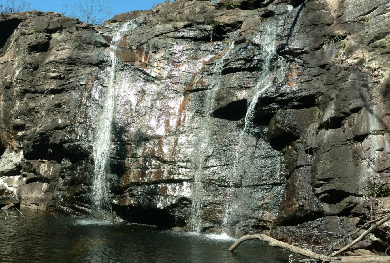
I detoured to Duffer Falls hoping to find an oasis among the burnt stuff, but the whole area was burnt and the trail was indistinct. The falls cascaded in three strands over reddish blocky rock into a sizeable pool and there were smaller falls lower down.
My destination, Boundary Falls campsite, had a few unburnt trees including some tall blue gums and a smattering of tree ferns. This was not a lively place. The bird survey guys had set up camp here so I was able to have a chat about the birdlife, and hear that they had found five scrub wrens. I found the bird life surprisingly prolific. My foot was quite sore after 20 kms so I was happy to stop walking. I did the very short walk down to Boundary Falls, which cascaded over granite into a dark pool; I could sense the water was freezing without touching it.
September 24 Boundary Falls to Mulligan's 19.7 kms. A second day of perfect weather. I started with a climb which was nice because I find downhill hard on my bad foot. There were more granite boulders and patches of wetland, and then I crossed the highway again and the trail became more of a narrow footpath.
The forest understorey showed good regrowth with ferns, grass trees and even some wildflowers. I was following Surveyor's Creek as it wound through wetlands passing granite peaks. At Dandahra Crags, an outcrop topped with jagged boulders, I started on the summit track but realised this would be too tricky with my foot on the way down, so I settled for coffee on a nearby log.
The trail continued creekside, with both banks showing bad signs of fire, to the confluence of Little Dandahra Creek and then I followed this creek. Soon I came to a large boulder edged pool. I sat with my feet in the cold water then had lunch. The rest of the trail was alongside this creek, which was really misnamed as it was wider than all creeks I've seen recently and full of water.
Towards Mulligan's the forest seemed a bit less burnt. I reached the end of my loop at the picnic area and straight away went to sit on a rock by the creek to cool my feet, seeing two lyrebirds on the way. Apart from masses of finches, honeyeaters, parrots, kookaburras and many other birds, I had not seen any wildlife, not even a lizard.
September 25 In the coolness of the next morning at 7am I hiked from Mulligan's out to The Needles (first picture) which was a 6 kms return side trip I could have made on my first day. (So my total hike here was 57 kms.) I walked through rainforest which was only burnt at the edges and had some nice tree ferns, but seemed odd as the understorey was bare. Towards the lookout the ground became increasingly bouldery. The lookout was truly spectacular: the deep Dandahra Creek gorge featuring endless folds of forested mountains and the curious granite spires jutting out into the gorge from near where I stood. It was the best moment of the whole hike.


No comments:
Post a Comment