The Carnarvon Gorge Great Walk in the sandstone belt in the Central Highlands of Queensland was a hike I wanted to do for a long time. I had researched it ages before the Queensland border was scheduled to be opened (when I didn't know that it would promptly be closed again), and this was the main reason I really, really wanted to get into Queensland once I had made it into NSW. This Carnarvon National Park walk starts by following Carnarvon Creek through the gorge (which is actually 30 kms long but mostly not accessible to the public) in the Carnarvon Gorge section of the national park, climbs out and then does a big circuit through the backside woodlands of the Mt Moffat section of the national park, returning to the base of the gorge again at the very end. It's a roughly 90 kms loop walk, excluding various not-to-be-missed side trips, which I planned to do in 5 days; most of the days would be short on distance for what I like to do but I could cope with this.
The drive into the gorge from the nearest town of Rolleston was lovely: distant mountains, paddocks with emus, cows wandering all over the road. By the time I got to the start of the walk at 10am the day was warming up.
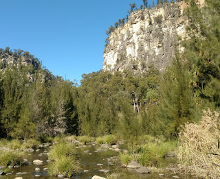
11 August, 15.5 kms. The first stage was busy with day walkers because this part has easy access to some very scenic parts of the gorge. There were high weathered sandstone cliffs to one side, fairly white with shades of grey and yellow, and further in the gorge was going to get much narrower. Up high on top of the cliffs were trees, barely discernible. Around the gorge were palms and cycads. The colours down there seemed especially bright in the sunshine.
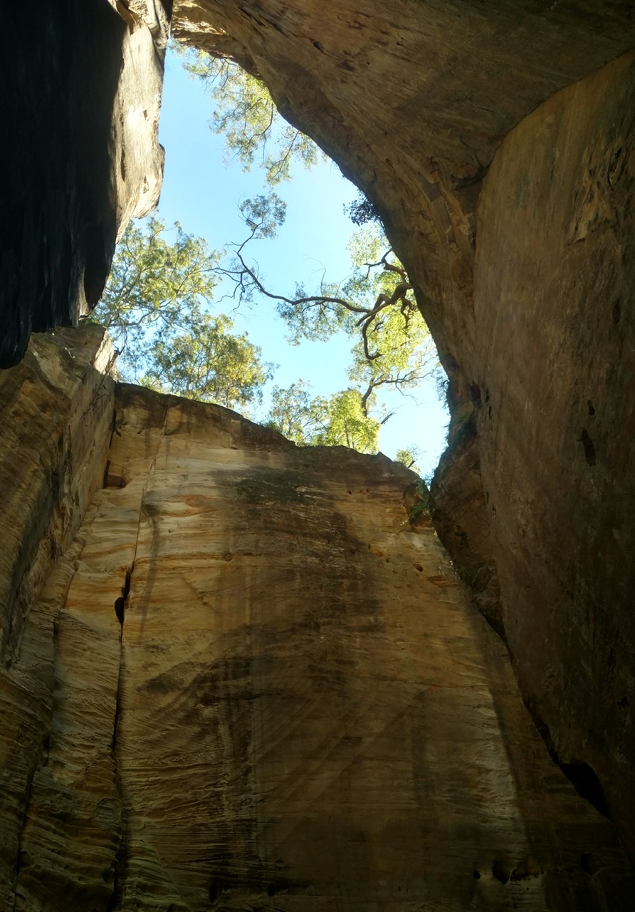
There were many detours off the main trail, starting with the Moss Garden, a rock pool surrounded by rocks covered in mosses. Then came the most interesting feature, reached by a network of steps and metal ladders, the Amphitheatre, where the high cliffs closed in on each other so that there was only a small chink open to the sky. Next came a very damp side gorge, Wards Canyon, with huge king ferns that usually only grow along the coast. Then a huge rock overhang, and later a similar overhang called the Cathedral, with Aboriginal rock art: stencils of hands, drawings of fences and carvings of serpents.
In between the attractions were numerous creek crossings on stepping stones and I wasn't too keen on these because I feel less balanced than usual with a pack. The water would have been ankle deep and the crossings were between 2 and 10 metres wide, and the stability of the stepping stones varied.
It was time for a break so I stopped by the creek where I had a great view of the cliffs and the water and I tried to make a cup of coffee. I was using a type of metho I had not bought before that was purple. Try as I might I could not get it to burn and eventually I gave up. A few minutes later some people asked me why I was taking water from the river, was I doing research? I said I was trying to make coffee and explained my problem and they shared my puzzlement.
The Big Bend campsite was on a bend in the creek and extremely picturesque beneath those high walls and with huge scattered boulders, with the gorge walls taking away all the sunlight so it was already cool at 3pm. I had a spot of trouble finding the campsite but luckily someone else arrived at the same time as me.
I told this guy about my metho problem; he looked at the bottle and showed me the words unsuitable for use in spirit burners. Oh dear. Cold food for me. Interestingly, when I later looked at the colourless metho I normally buy I saw that those bottles say the same thing. The purple metho is treated and coloured so people won’t drink it. I soon poured away the purple stuff and used hot water kindly donated by fellow hikers most nights to cook my noodles. I found it more inconvenient making coffee with cold water because the powder refused to dissolve completely.
The tops of the cliffs were very slightly glowing orange in the last of the sunlight for several hours. I slept to the sound of running water.
12 August, 16 kms. Leaving the Carnarvon Creek gorge the day started with a walk through Boowinda Gorge, a tiny side gorge with high walls so no sunlight could get in and the watercourse was filled with debris. It was cold in there. Then I had a steep and rugged climb out of the gorge and continued in light woodland heading towards Battleship Spur which I was surprised to see really had the profile of a battleship. As I reached the lookout two kangaroos bounded away.
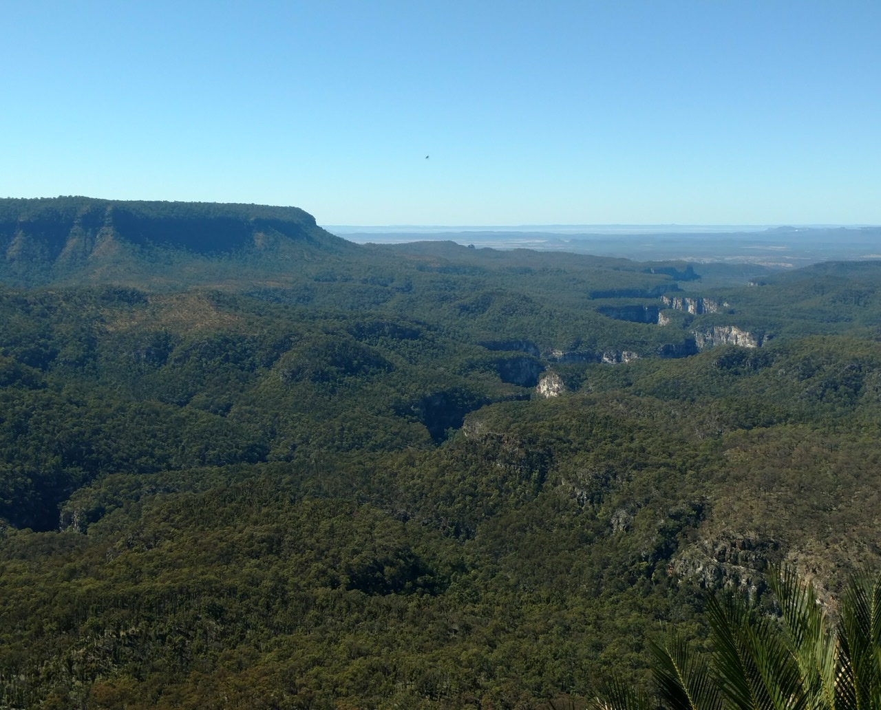
The view from Battleship Spur lookout (1074 metres) was fabulous: the Carnarvon Creek Gorge like a deep curvy slash in dense forest with occasional patches of white cliffs visible. I could see way beyond the gorge into the surrounding farmland but at the same time there was a vast amount of forest.
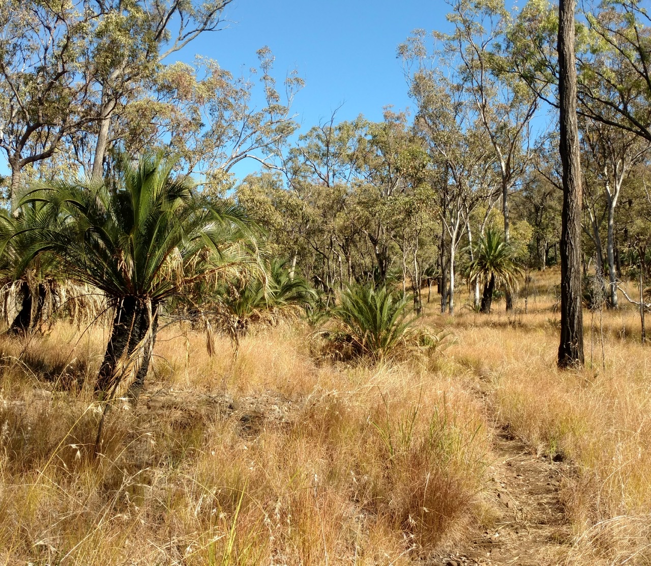
After this the walking was through the grassy woodland, or was it wooded grassland? The grass was about thigh high and yellow, and the silver leafed ironbark trees were medium height. There were cycads too, which became increasingly plentiful. The path was a single track which must have been made with a scythe after the wet season. It wasn't too hard to wander off onto animal tracks by mistake but as the terrain was so open it was not difficult to get back to the trail. I like this open woodland because you can see other scenery through gaps in the trees and I could see many low peaks nearby. It was a hot afternoon with a slight breeze.
Gadds campsite was in the woodland beneath a conical peak and there were two water pumps under a shelter. Just as I arrived a couple of kangaroos jumped away. The same crowd as last night turned up which was nice. It was a beautiful starry night.
13 August, 16.5 kms. I made a late start because I sat around chatting. Today's walk was all in the woodland, initially on a wider trail and then back to the grassy single track, mostly on a ridge. The cycads became taller, often taller than me. After an early climb with several false summits I had nice views over many peaks in this region of the national park, where Mt Moffat is the highest peak. It was again a cloudless day.
After a while the trail came to a dry creek and the terrain changed, the ground became sandy and the vegetation changed from gums to casuarinas. I thought I had left these on the coast.
Then I returned to the grassy woodland and came to a more major river crossing on a long suspension bridge. It didn't look like the river had seen water for a long while. On the far side was my West Branch (hikers') campsite; this was just a scruffy clearing while the adjacent car campers' campsite was landscaped and had toilets.
I ate lunch over there and when my hiking mates arrived we all decided to camp there. We did good social distancing, camping far apart although we behaved like we were travelling together. In the evening we shared a campfire with some German backpackers.
14 August 36kms. This was a huge day for distance. I started with another climb, and higher up the grass was green rather than yellow and there were smoother barked gums. The woodland was denser. It was windy and cloudy at first but quite suddenly the clouds vanished and I had another blue sky day, but a bit cooler due to the wind.
After 11 kms I came to the dirt road leading to Preawaddi Gorge lookout and someone had suggested I go there so I dumped my pack and set out on the 5 kms return trip. This was easy fast walking through yellow then green woodland but the lookout was a tiny bit disappointing: the view was over a deep chasm with forest far below and dramatic but no view of the river within.
Once I had collected my pack I was into the Mahogany Forest which was green with a ferny understorey, grass trees, cycads and tall stringybarks. It was more stately than the earlier woodland but lacked views through the trees. Some of the wattles were flowering.
I got to Consuelo campsite and stopped for lunch; it was not much of a campsite, a small clearing which did not look welcoming, with a water pump and shelter. I was already quite tired but I didn't linger.
About half way to the next campsite I was caught up by a group of women running the entire trail in a day and a couple of them wanted to walk for a while; we ended up walking about 4 kms together chatting and this really got me moving as they had little luggage so they could walk much faster than me. We saw a feral black pig right by the trail staring at us; most hikers see lots of pigs and the damage they have done to the forest is very noticeable: it looks as though heavy machinery has been through.
Cabbage Tree campsite was a lot nicer, right in the forest and surrounded by low cabbage tree palms, and I met a new crowd. I didn't ask for hot water (the first person I told about my lack of fuel gave me a disapproving look) but instead I cold soaked my noodles and they tasted just great. The wind had come up and by 7pm it was raining lightly.
15 August, 16.7 kms. The final day brought a return from the forested tablelands to stunning gorge scenery. I soon found I was walking along a ridge and then out on a spur with views over huge chasms and tall sandstone cliffs. The path descended several times into dry gullies with cabbage tree palms. It was more cloudy than the previous days.
After more forest with casuarinas, smooth barked gums, flowering wattles and of course cycads I came to the turnoff for Boolimba Bluff lookout and from here was an amazing view of many kms of the main Carnarvon Creek gorge; I was now very close to this gorge after a few days' absence. I descended through Boolimba Gorge, which was a narrow and steep side gorge, its sides filled with damp plants, on a series of ladders and lots of steps, and was then back at the Carnarvon Creek.
Shortly beyond the side gorge some other hikers were stopped by the trail, and I found they were watching a big python which had been reluctant to leave the trail.
The main gorge was again busy. When I got back to my car the first thing I did was get my old metho bottle and make myself a cup of coffee with hot water!


No comments:
Post a Comment