29 May 2022

I Finish the Heysen Trail


Finally I’m off to Burra to complete the Heysen. I left Burra to Spalding until last for two reasons: the bus timetable is such that I am compelled to spend eight days on a five day walk, and this part of the trail gets a worse wrap than the rest. In the event it did have some very uninteresting parts but also some of the best scenery on the Heysen, and the spacing of the campsites meant it was not hard to spend seven (shortish) days on it.

May 19, 2022 Burra was cold when I emerged and while I was waiting for the bakery to open I learned about the feud between the owners of the town’s two other cafes.

I had road walking out of Burra, through North Burra which was full of historic buildings and then by paddocks, before turning off to follow fence lines. More steep hills including the worst since the incredibly steep one on the south coast. The hills started out dry but became greener and I can see how the lambs have grown in a few weeks. There were some nice views from a ridge top over more hills and out towards the northeastern plains. It was sunny but there was an icy wind. I got to Wandallah shelter for an early lunch; the shelter and toilet were in a fenced enclosure although I saw no sheep around. I was keen to put up my new tent. Then I sat in the shelter, out of the wind, admiring it. 16 kms

May 20 I got up late so the sun had been out for a while and it wasn’t too cold. My first ten kms were along fences, never a flat moment, including a dead straight four kms where the only excitement was crossing on a stile to the other side of the fence.

(The farmers must have had a laugh agreeing the route with the Heysen people; here and elsewhere there would clearly have been other ways to do this.) I had had enough of fences and was glad to turn onto a track across a reserve with mallee scrub and saltbush. I was also out of the cold wind for a while. There was a view of the Mt Bryan range and to the east endless farmland. Black Jack hut with its completely open-air toilet (the walls fell down last year) was a new clean cabin but I camped. 16.5 kms

May 21 Today’s hiking was as good as any on the whole Heysen and totally unexpected. It was a perfect sunny day. I continued in the non-farmland with mallee and saltbush and passed an atmospheric ruined hut,

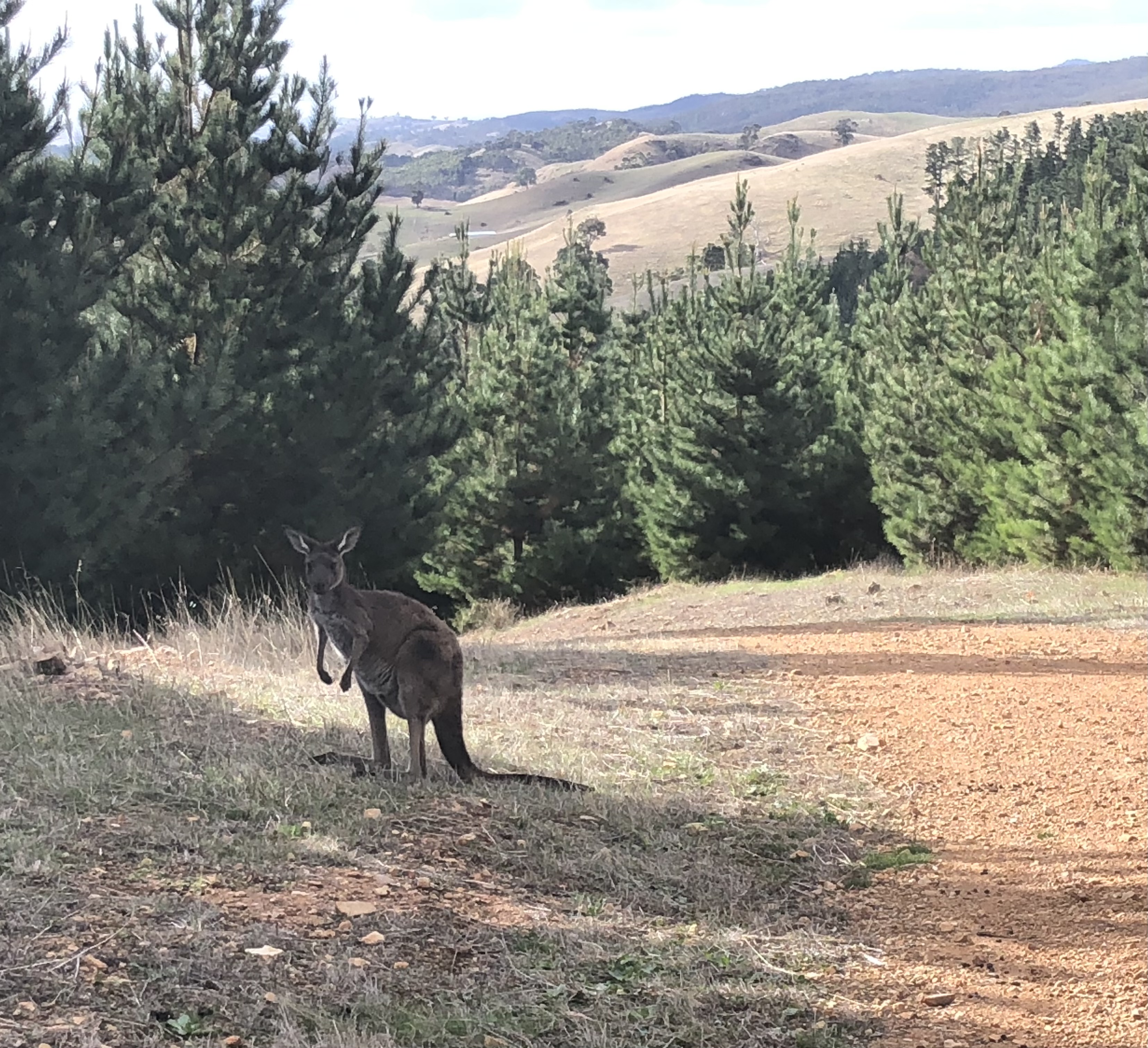
then turned into an official but unnamed reserve. This was a wonderful bowl with many rock-capped peaks surrounding and undulating hills, scrub on red earth and kangaroos.

During a break off track I saw a sleepy lizard.

The trail crossed many dry gullies and wide stony creeks and went through sparse forest. I saw beautiful green/blue parrots (Mallee ringnecks) and took another break in a steep sided rocky gorge. And this area doesn’t even have a name! I was just thinking how remote the place felt when a runner came past. 

Then I was in Caroona Creek Conservation Park and following the creek until I reached the shelter.

By early afternoon the day had cooled down and the wind came up. The shelter was among the mallee and was spacious enough for me to try my tent in freestanding mode on the pavers. A mouse got inside my tent in the night, woke me up running all over my sleeping bag, and later bit a hole in the netting from the outside trying to reach the used food wrappers I had put in the pocket above my head to evade mice. 15 kms

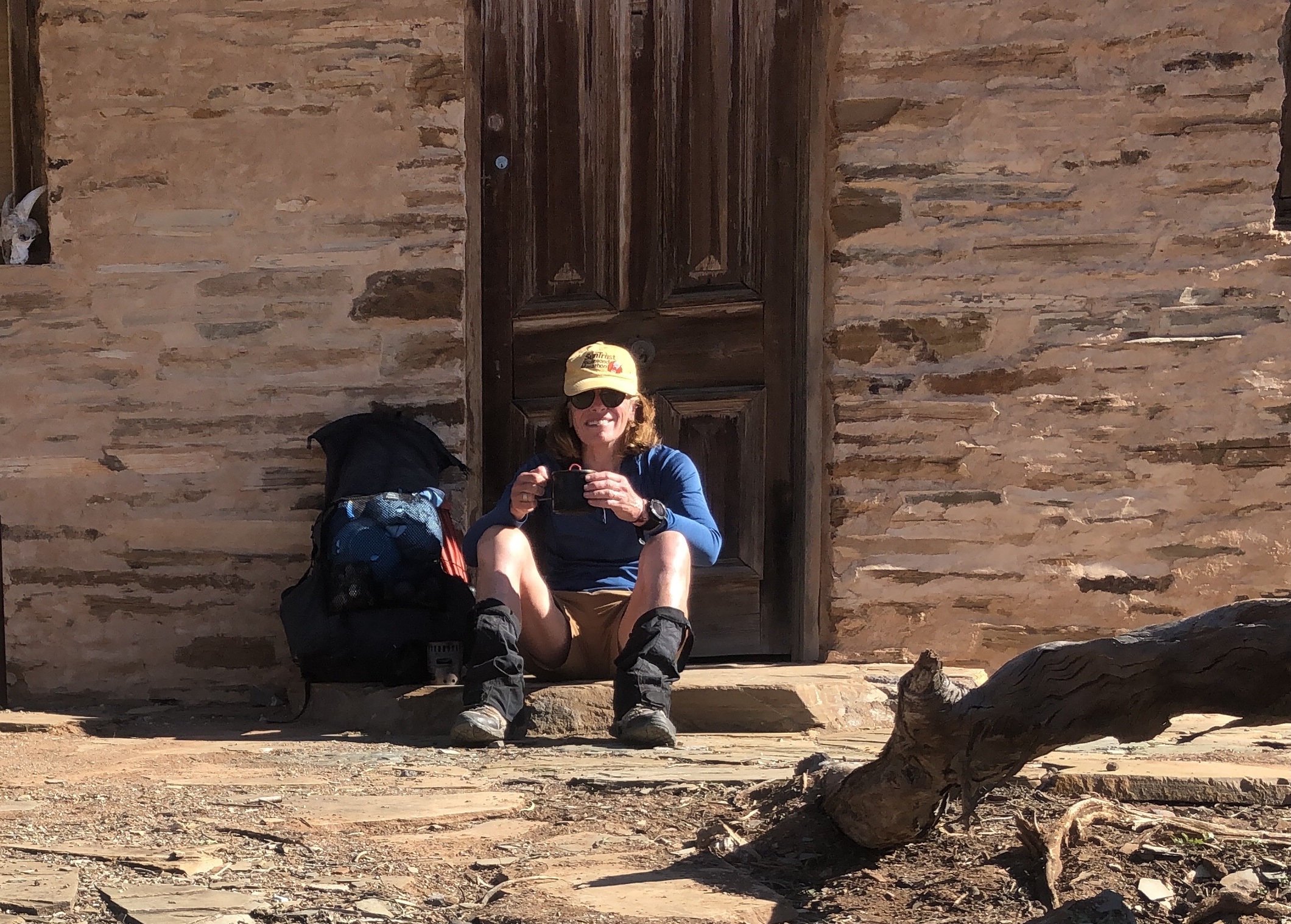
May 22 A much warmer morning. I was walking on a scrubby plateau of saltbush and bluebush with stringybark mallee, mainly on 4WD tracks. I passed a former homestead where only the fireplace remained. Then I came to Tourilie Gorge, surrounded by high scrubby hills. I took a short detour to Tourilie hut, which was in an idyllic setting above the creek but below the hills, and had a break sitting on the porch. (Selfie.)

Just after leaving I saw an emu tearing across the hillside while a bunch of sheep watched, bemused, and then they turned their attention to me. 

The gorge was great; a bit less rugged than the Flinders gorges but similar, and I walked in the rocky/shale chips creek bed.

The hillsides around were bare red earth and spinifex. I had a long climb out of the gorge through scrub with a view of higher hills on the horizon ahead. It’s like a chunk of central Australia has been transplanted into the farming country of mid north SA.

A bit later I was back in farming country on gravel roads. It was very hot and exposed walking on long straight roads. I was glad to get to Mt Bryan East schoolhouse, a well equipped but rather trashed Heysen hut. Pleased to find a lot of reading material. The hut marks the half way point of the Heysen. I slept inside without rodent activity. 18.5 kms

May 23. Some gravel roads

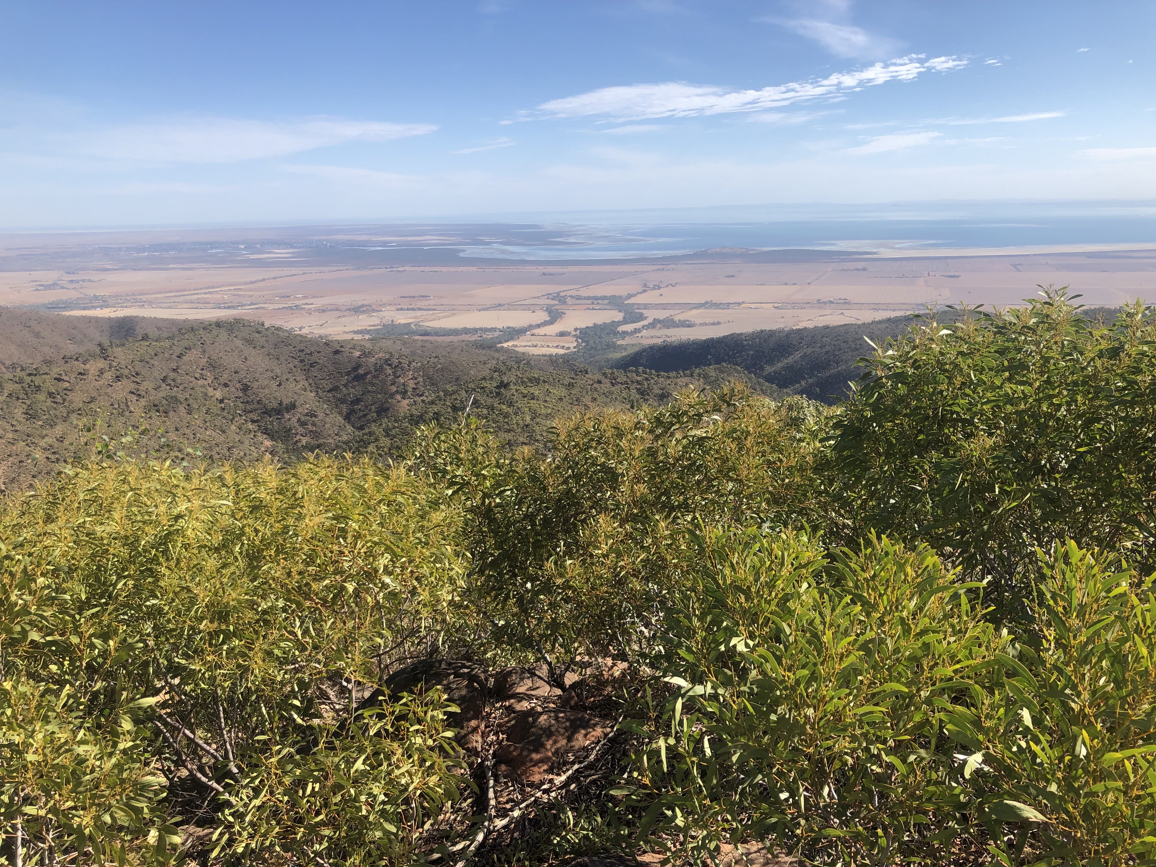
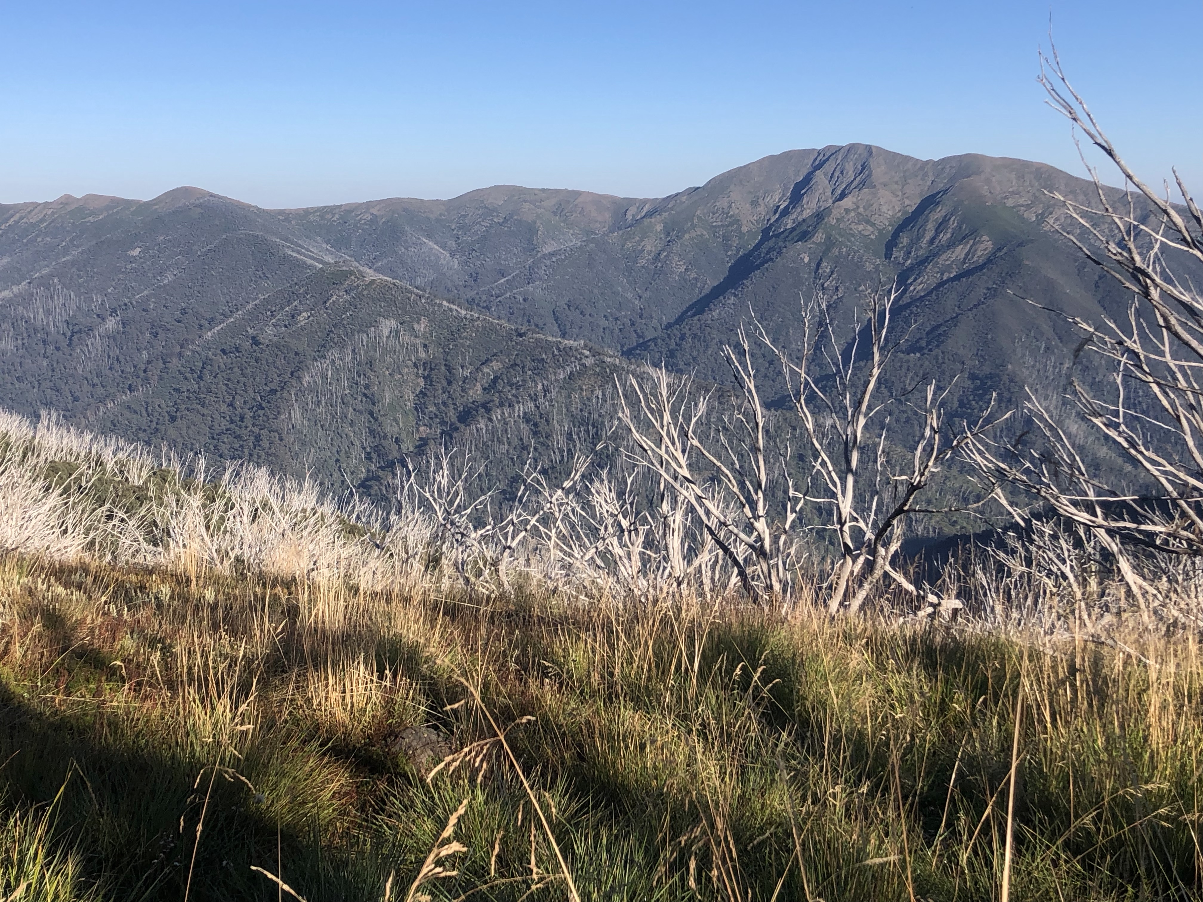
then I started my ascent of Mt Bryan on a mix of trail and grassy slopes. I veered off the curriculum to do some scrambling over rocks and rejoined the trail near the grassy summit (935 m). Surprisingly to me this is almost the highest point on the Heysen (Mt Brown is the highest point followed by Mt Remarkable followed by Mt Bryan). There were sheep and lambs up top. The 360 degree views were amazing over green hills, farmland and many wind farms, all working away. I sat by the trig point to have a coffee and a hiker came by from the Hallett direction; we had a long chat about our hiking experiences.

I set off keenly on the descent and was soon going the wrong way; I realised I had another hump to get over. The real descent was through green paddocks and very pleasant in the sunshine, then the last kms to Hallett were on gravel roads and quite dull. I went to the store to buy food, eat food and have a rest. The designated sleeping area is the disused Hallett railway station and I decided to camp; a good call as it wasn’t long before I saw a mouse in the building. 18 kms

May 24 Today started out like it was going to be my most boring day of the entire Heysen. Long straight gravel roads, brown ploughed fields, no animals and a fleet of huge trucks going back and forth throwing up masses of dust. I walked towards wind farms then more wind farms. 

Around midday I met two Heysen hikers coming from Spalding, and after a chat they took on my boring roads and my walking improved markedly. Soon I passed the quarry the trucks were coming from so no more dust. The route climbed onto a dry grassy range with extensive views (mainly brown farmland and wind farms) and I remained high for the rest of the day. I came to Whistling Trig tank, notorious for being windy, and it was windy but I’m sure it gets a lot worse; I ate lunch there hanging on tight to my roll. Then I undulated along the grass and thistle tops doing the usual fence line thing. I had no campsite to aim for (there’s nothing for 49 kms between Hallett and Spalding) and when I reached a saddle at the foot of a steep hill I decided to stop as it was secluded and I saw a flat spot. It was challenging to camp among thistles and I laid out all my things under my air mat to protect it.

Later I heard/noticed sheep in the lower part of the paddock. 28 kms

May 25 It started raining in the night and the wind picked up. In the morning there were sheep close by but they soon ran away when I came out of the tent. I saw a huge rainbow over the valley. I remained on the hills a bit longer, gradually descending, and the weather was clearing apart from the wind. I came to roads and then the Bundaleer aqueduct path and I stopped for a break but it wasn’t pleasant sitting in the wind.

I continued beside the aqueduct heading into the wind and having a change of pace going through many gates. I startled a sleepy lizard so much it had its tongue out by the time I was close. The highlight was a huge bridge over a wide dry creek. It was basically a slog. I turned off for a last fence line and came into Spalding. Very quiet there. I had a coffee and pie at the general store (grateful that it was open) and got a room at the partially open pub. 21 kms

I have now completed the Heysen apart from a small gap close to Adelaide so I took the bus back to Adelaide to walk that bit.

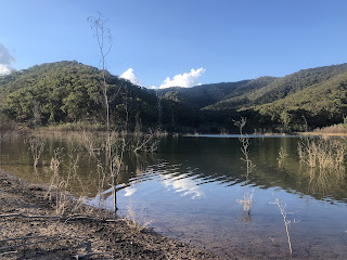
May 28 This promised to be my second wettest day on the entire Heysen (my wettest being my very first day leaving Quorn). I took the bus to Morialta Conservation Park and went back to where I left the trail last December. It was already raining. I climbed steeply and had some views over Adelaide before entering a cloud and remaining inside it for hours. I was walking through forest but I could only see the trees immediately next to the trail. After some road walking I had a long and extremely steep descent, which I found really nerve wracking, to a flowing creek. (Some sheep were there and they didn’t even bother to run away.) This gave nice flat walking with better visibility but was a prelude to a long climb in Montacute Conservation Park. At the top I entered Mt Crawford state forest and was pleased to see I only had ten kms to go. 

I saw some other walkers along here and as we descended through the sticky clay I caught up to them. They were walking a bit of the Heysen and had been doing parts of the trail for ten years. I ended up walking with them for two hours. This was great - I was quite cold and wet and we had a lot to talk about, which took my mind off the discomfort.

It transpired that one of the guys was someone whose posts I’m always reading on the bushwalking forum. But then a truly amazing coincidence emerged: when I was at Ironstone hut in Tassie a local hiker told me a story about how he had recently found a mobile phone while hiking off track and had been able to contact the owner and the phone had been lost 18 months prior but still worked; when I heard this story it was pretty surprising considering the local rainfall and passage of time. One of the walkers today was the owner of that phone! He just randomly mentioned that he once lost his phone in Tasmania and it was found, and every detail matched.

Towards the end of the walk the weather appeared to be improving with a little blue sky, but it soon poured again. We parted company at their car about two kms before Cudlee Creek and I continued alone, then we met up again at the cafe; it was great to be able to celebrate my finish with other walkers. 26 kms

And that is how I finished the Heysen. 

Total distance walked (including getting on and off the trail): 1178 kms in 51 days

Here’s the timeline:

Cape Jervis to Mt Compass: 135 kms; 29/4-3/5/21

Mt Compass to Bridgewater: 68 kms; 8/4-10/4/22

Bridgewater to Morialta Conservation Park: 30 kms; 14/12/21

Morialta to Cudlee Creek: 26 kms; 26/5/22

Cudlee Creek to Tanunda: 76 kms; 4/5-7/5/22

Tanunda to Burra: 166 kms; 26/5-31/5/21

Burra to Spalding: 134 kms; 19/5 - 25/5/22 

Spalding to Crystal Brook: 82 kms; 30/4 - 2/5/22

Crystal Brook to Quorn: 191 kms; 11/4-20/4/22

Quorn to Parachilna: 270 kms; 11/7- 21/7/19


09 May 2022

More Heysen

As soon as the Heysen was about to be fully open I rushed off to walk more of it, as always having to fit in with the infrequent bus services. A walk north from Spalding to Crystal Brook was convenient for the trail opening (just about), the buses and for me. After that section I could fill in a gap further south. 

April 30 Last day that the Heysen is officially closed. The first 19 kms out of Spalding followed the Bundaleer aqueduct (no water) beside harvested wheat fields and sheep paddocks. It was gently rolling dry hills and easy walking. A lot of the Heysen route here is shared with the Mawson bike trail and this was lucky for me because the Mawson doesn’t close for the fire season, so even without a bike I could be where I was quite legitimately.

I had a break at Bundaleer campsite which was in a pretty setting among trees. After that the trail was much more rewarding: I walked the length of a shallow valley, crossing many eroded gullies, lots of grass trees on the hillsides and lots of sheep, who thought the trail was for them rather than me; the lambs were especially confused. I hoped the farmer would not be alerted to my presence by the din they made.

Leaving the valley the trail became wooded and I got to Curnows Hut, a restored stone hut in a forest clearing, for both Mawson and Heysen users. There were a lot of birds around the hut, noisy and busy. I camped outside the hut. 31.5 kms

May 1 Fairly soon after leaving the hut on wooded trails I found I was not in the right place and I did a little variation to get back on track, doing an extra 2 kms. (This error, I found later, was the result of an earlier reroute where they had not removed all the reroute signs.) It was all forestry tracks although not much in the way of trees. I spent the next hours crossing farmland, following fences or creeks and seeing lots of sheep. It was really pleasant and quiet. A lot of the trail was through high grass where a way through had been flattened, presumably by the sheep since walkers should not have been there until today. Then I climbed onto a stony ridge (everywhere the ground is covered with stones unless they have been cleared into heaps) of dry hills and walked along with dry hills to my left and a patchwork of fields to my right. I could see a long way in all directions. There was the occasional ruin of a stone hut. 

On my way down I met a group of three hikers and one of them was the woman I met at Waukerie Gorge on my previous Heysen section, like me doing another section.

The next part was a long slog on a gravel road into Georgetown, 8 kms which felt longer. I met a man walking a bit of the Heysen with vehicle support; he had been with one of the organised Heysen groups to do a big chunk but they had to abandon their plan because so many of the group got covid. 

Georgetown looked a cute little town, nice and sunny, so I made myself coffee in the park; on Sunday afternoon everything was closed. I continued on to Hiskeys Hut, an easy few kms on a gravel road. The hut was another restored stone place with a view over the yellow hills. It was a lovely still evening with a rim of red along the horizon after sunset. I slept in the hut. 30.5 kms

May 2 I had another morning of fence lines, sheep grazing and farmland, less hilly than yesterday, just undulating. Again it was nice in the sunshine and silence (apart from birds doing their thing). This is reputed to be a very dull part of the trail but I like it.  

I stopped for an early snack in a small patch of trees in a gully. After that the route was back on dirt roads, with a completely unnecessary detour up a hill, then the last 2 kms were along the highway. Until this highway not one vehicle has passed me on any road I have walked during this section; I have always been able to walk down the middle of the road.

It had become hot and I was keen to reach Crystal Brook. I did not expect much to be going on there so I was happy to notice a busy bakery/cafe. I went inside for a hard earned doughnut and coffee. 20 kms

Then I got the bus back to Adelaide to walk part of a section south of Tanunda.

May 4 I got the bus to Cudlee Creek (the only passenger) and took the short spur trail onto the Heysen. I had some roads before going into forestry plantations and climbing. I came to a wonderful grassy ridge - at the same time as a brief rain shower - and was up there a long time with great 360 degree views over farmland, small settlements, orchards, reservoirs and rolling hills. It was all so much greener than I have been used to. I had a coffee break sitting on a stile. Then I had steep hills in woodland, hard work. I went into another area of plantation pine forest and followed another ridge. More rain was coming and I wanted to get to Scotts shelter before it started. Meanwhile I had another steep descent and corresponding steep climb.

Near the top the pine trees gave way to mallee and grass trees but the shelter was among pines. I was quite cold, even though it had been sunny most of the day, and I was pleased the shelter gave good protection from the wind which suddenly came up. The rain didn’t return until the night but I never warmed up. At dusk masses of kangaroos came to graze on one cleared hillside. 20 kms

May 5 It was cooler but sunny. The forest morphed back into native bush and I entered Warren Conservation Park; the trail went right across the middle of the park, crossing a huge bowl of grass trees, stringybarks and wattle. All I could see was bush. This involved a long downhill to a dry creek and a long climb. Once out of the park I continued to climb a grassy ridge to the top of Tower Hill with masses of kangaroos and great views of forest and farmland. I descended back into Mt Crawford forest and then had a choice of routes; I picked the one that went past a picnic area among the pines so I could have a break. I came to Warren Reservoir, crossed it and immediately had a problem: a large sign across my path said Danger, Tree Felling in progress, No Access. It would be a long way to backtrack so I decided to risk walking through the area as I knew I would hear a lot of noise if they were felling trees and I could quickly turn back. I marched those kms rapidly and saw/heard nothing. This did mean that I reached my planned campsite, Centennial Drive shelter, rather early. That too was lucky as it soon started raining and later rained a lot. The shelter was in a large clearing between the forest and the South Para River (lots of reeds, little water), beneath Mt Crawford. I put up my tent inside the shelter. 19.5 kms

May 6 When I got up I was in a cloud.

I walked up Mt Crawford knowing I wouldn’t see anything; it was a nice native bush trail. The descent on steps was a nuisance for my knee. Then I had a stretch of steep but short roller coaster hills between paddocks and pines, at the end of which I was once again in the wrong place. I made my own route to the Old Schoolhouse campsite and had a break, having done an extra 4 kms, and I enjoyed a short interlude of sunshine.

From here I appeared from my gps to have a choice of routes so I opted to do half on one and half on the other using a linking road. I began back in the pines then had a nice ridge top wooded section on the Wirra Wirra hills. I switched from this half to gravel roads, hilly, beside vines with autumn leaves and sheep paddocks. I am clearly in the Barossa now.

I had lunch sitting on a rock and watched the sky get black while the wind picked up. Soon it was raining but not for long. I walked along fences in a wooded reserve, then more dirt roads and a return to the forest. It seemed a long day, always up and down; I never realised SA is so hilly. 

After a final batch of hills, walking between paddocks of cows and pine plantations, I got to Rossiters hut which was small with a great outlook over the forest towards Mt Kaiserstuhl. I read about the resident mice in the log book and chose to camp. 23 kms 

May 7 Cold but sunny morning. It was mostly downhill today, first in the grass tree/tea tree/stunted gums Kaiserstuhl Conservation Park and then along fences. Suddenly there are lots of scattered small granite boulders. Coming down I had a fabulous view over the whole Barossa Valley, dotted with the yellow of the vineyards. I stopped for coffee at a stile to enjoy the view. The last part into Tanunda was along flat straight roads and something to be done as fast as possible, proper coffee beckoning. 13 kms


23 April 2022

Heysen Trail reprise

It was high time for a return to the Heysen Trail but the trail closures for the fire danger season were delaying me. In mid April I could start a northern section and I decided to tag on the half section in the south from Mt Compass to Bridgewater where camping was allowed and only small portions of the track might be closed (sshh). 

April 8 It was good to be back after almost a year away (save a day walk in December), however this seemed a long hard day. It was hot, there was plenty of tedious road walking and the leg with the bad knee kept cramping. I started where I left the trail in early May 2021 with a long bitumen road walk out of Mt Compass to get back onto the trail and then moved onto a mixture of gravel roads, single track through a couple of wooded conservation parks with ferns and grass trees (Finiss and Mt Magnificent), forestry roads in the Kuitpo state forest (pine plantations on one side and native bush on the other) with a short section among the pine trees. I saw quite a few kangaroos. Everything was very dry apart from a lovely creek where I had a long break. It wasn’t clear if all of the trail was open but I was happy to see Chookarloo campsite had other campers and there was water in the tank. 29 kms

April 9 I went into woodland and then dirt roads and I suddenly noticed the trail markers were leading me on a different and longer route than was showing on my Heysen gps track. After a spell back in the pine forest I found I was still not on the gps track and I was going to do an extra 5 kms before reaching my first scheduled rest, despite following the trail markers the entire time. I was not happy and I was already tired when I got to Rocky Creek campground after 17 kms rather than 12. I had coffee sitting in the shade of the water tank. It was another hot day. 

When I left I resolved to follow the gps track and with 400 metres of trespassing on SA Water property where the official route makes a big detour - a mob of kangaroos saw me and I’m sure they wouldn’t snitch - I clawed back a couple of the extra kms. There was a maze of forestry tracks so I had plenty of options. I went through a bit of conservation park (typical Heysen thing of being squeezed between a fence and the bush while there was a good track on the other side of the fence and lots of trails through the bush), passing a past gold mining area. Farmland followed with some curious stretches of boardwalk and in a few places I had to wait for the cows to move off the trail, and then some climbing along fence lines. I could see the Mt Lofty spire in the far distance so I knew I was heading in the right direction. The last part was on bitumen roads leading into Mylor.

I intended to camp at Mylor oval, which in my notes was the recommended Heysen campsite; when I got there I found they had a special event on and the whole town was there, plus No Camping signs. I had nowhere else to go (that Heysen issue again). Fortunately I found an area adjacent to the oval (with a shelter for cooking) so I cooked, then sat and waited for it to get dark to put up my tent. 31.5 kms

April 10 Only a short way to go today, luckily, because when the sun came out it was immediately blasting heat. I had a brief foray into Mylor conservation park, an unnecessary trail extension but lovely stringybarks, then the remainder through a bushy reserve above the road which was surprisingly nice. 

At the finish line I headed straight to the Little Cog cafe by the old mill, which must be the only cafe in Bridgewater as it was hopping. 7.5 kms

The next day I went north by bus to resume the trail in Crystal Brook and head to Quorn where I began my first outing on the Heysen in July 2019.

April 11 Just a stroll to get out of town today and make the distances work on the other days. I followed the creek, dry and nothing crystalline about it,

first at the edge and then on a dirt road to Bowman Park hut (bunk beds, furniture, inside tap) surrounded by dry bush by the creek bank, rabbits, crows and kangaroos, open only to Heysen walkers. Sometimes there’s nowhere to sleep, sometimes there’s luxury. According to the logbook nobody had been there since November. Up the road was Bowman Park with the grass being sprinkled and a bunch of RVs. I took a mattress onto the veranda and slept there, wearing my head net because of the mozzies. 4.7 kms

April 12 It would have been nice to follow the Crystal Brook next but they’ve rerouted the Heysen along roads, luckily quiet and with some views over the farmland. This also meant additional kms. After the detour I climbed to a ridge and undulated there for the rest of the day. All on roads which were peaceful, and expansive views with patches of green but mainly yellow/brown hills and few buildings. It became very hot and then very windy. I called in at a property where they have a water tank that walkers can use since the Beetaloo tank was destroyed; I didn’t see the owners but I found the water. I had a few stops when I saw shade and ate lunch at the former Beetaloo shelter site under big trees. Then I had a short climb to the Wirrabara forest (native bush) and the replacement shelter, where I was pleased to find water in the tank. I decided to sleep on the bench in the shelter. 25 kms

And 13 Windy night and windy morning. The trail took an immediate turn for the better. I embarked on a serious roller coaster of a walk along the edge of the southern part of the Mt Remarkable National Park as I climbed towards a couple of TV towers on a hill called the Bluff. I was deep in mallee forest with views over Port Pirie and the Spencer Gulf. It was hard hilly work and there was no view from the TV towers. I went on, with a sharp and loose descent that was like walking down a rock slide, interspersed with some steep uphills. I came to a clearing and was surprised not to see any trail markers; to my horror I realised I had come the wrong way from the towers. Retracing my steps the 2 kms back up the trail was awful and I couldn’t do it in one go as it was so hot. (In my defence I had been confused by seeing a Heysen sign at the start of the track; I don’t have time to read wordy Heysen instructions and it actually said not to go that way!)

The real route was much more pleasant, undulating on a sealed road to a brand new lookout platform (over the Gulf)

and then returning to a rough track (Go Cart Track) in mallee in Wirrabara Forest. As I passed over Frypan Hill (views east towards a mountain range) I heard a commotion in the bushes and a couple of wild goats appeared looking distraught; then I saw several more, all having trouble escaping from me because the bush was too dense. When I got to Go Cart Track shelter it was just that: a roof. Also, thankfully, a tank with water. 

Soon after I got there a ranger arrived and commented that the camping season hadn’t started yet (2 days away), but he said Don’t worry, you’re close enough. Then he told me not to be alarmed if I heard rifle shots, as they were hunting feral goats.

The shelter was in a nice spot with views over the top of Telowie Gorge to the Gulf far below and I saw town lights after dark. I planned to sleep al fresco under the roof as there was no chance of getting tent pegs into the hard ground. 23 kms

April 14 Again a really windy night. I continued on a narrow ridge in the forest, (no more goats, only kangaroos)

then a long downhill on single track into a deep gorge; the creek at the bottom was tiny, and then I had a long climb back up on a rough track. Soon I left the forest and was walking over grassy hills with sparse woodland. It was very peaceful although getting hot. Some of it was just cross country without a trail.

Then back to farm roads. It was really muggy. For a short while the route went along fences and I stopped at a broken cattle trough for a coffee break. The last three kms into Murraytown I walked along the highway as the town is off the trail. I could see a prominent landform in the distance which I guessed to be Mt Remarkable. Everything in Murraytown has closed down but they turned the town park into an official campsite, a lifesaver for Heysen folk. The caretaker said I was early for a hiker, coming even before the fire danger season was over. 26 kms 

April 15 I walked out of Murraytown along the highway then moved onto farm roads with grazing sheep and wheat fields, Mt Remarkable always there in the distance (but getting closer).

Again it was hot, still and peaceful. It takes a few days to get to enjoy the Heysen road bashing. The land was gently rolling with patches of gum trees. I saw green parrots, wagtails, galahs, honeyeaters and heard a lot of kookaburras. I did a typical Heysen roller coaster along a fence line crossing several gullies, trying to sneak past the sheep sheltering under trees, and walked the last part into Melrose on a dirt road.


I needed to resupply in Melrose and I had been very worried that everywhere would be closed on Good Friday. It looked dead as I arrived but the place is an MTB mecca and the bike shop slash cafe was doing great business, and the servo slash food store was open. The enormous caravan park was so incredibly crowded that I was now very relieved they had said they had no room when I enquired.

I lingered several hours in town, bought food and set out for the summit of Mt Remarkable. It was 31 degrees. For some reason I thought the climb was going to be quite short; it wasn’t that short (6.5 kms) but it was very zigzaggy and gentle. It was all in forest, crossing numerous huge rock flows and gullies, with views eastwards where I had come from.

The summit (960 metres) was a nice cleared area with benches among the gums, grass trees and a white flowering bush I see everywhere. It was hard to get a view through the bush. There were kangaroos snacking. So I enjoyed a snack too and decided to stay the night. I saw an amazing red sunset through the trees to the west and then the almost full moon just above the treetops to the east. 25 kms

April 16 Yay! The Heysen is officially open today, up north. I woke to see a rim of bright orange on the horizon and a bit later I saw a beautiful sunrise. The start of the descent (steeper than my climb) was in the forest and then I came out onto rolling grassy hills with scattered gums. I stopped at Grays Hut, in a large clearing, where a hiker was packing up - we had a long chat - then I sat in the hut enjoying the breeze through the doorway.

The trail continued over dry hills with densely forested ranges in the distance. I soon found myself off the route and went cross country to get back. The Heysen seemed unnecessarily complicated here and I was constantly losing the official route when the trail I was on was perfectly fine. There were whopper hills and it was hot. 

Firmly on the correct path I was getting a bit bored with the relentless hills (but liking seeing so many kangaroos) when the route had some surprises in store. First I followed a grassy creek. Then I climbed up a significant hill deep in dry forest where the trail was barely discernible; at the top (around 600 m) was a huge cairn and great views over forested mountains and the plains around Wilmington. And Mt Remarkable.

The descent was very rugged, rocky and hard to follow.

At the bottom was Stony Creek shelter, by Stony Creek, which was the stoniest creek I’ve ever seen, in a gorge filled with the distinctive yellow trunked SA blue gums.

(Shame about the large number of bees but they went to bed early.) It was a wonderful place and I made up my bed on the platform. This was my first windless evening/night and it is so great to be able to sleep outside like this. 18.5 kms

April 17 I did the short walk into Wilmington, wondering if it would be crazy busy like Melrose. It was not; it was a quiet place on the road with just a little bit going on. I headed straight to the cafe as everything was closing early on Easter Sunday. Then I arranged a room at the pub, bought food, had a chat with the hiker from yesterday who turned up and had a chat with a couple who help maintain the Heysen along here. 7 kms

April 18 Quite a challenging day and not really what I expected. I left Wilmington and followed the roadside reserve to Horrocks Pass then turned to climb high above the pass. The surrounds were dry hills some of which were covered with only juvenile grass trees.

I was surprised to be looking down on Wilmington as I thought I was some way away by now, and the other way I could see the top of Spencer Gulf, a wind farm near Port Augusta and lakes beyond. It was a cool day and windy. I stopped at a new hiker shelter (installed last week) on a hilltop where a gale was blowing and it had not rained recently so there was no water in the tank. It was so odd to be cold after all the hot days. As I sat there two hikers came by.

The next part was real hardcore Heysen: along fences, random bits of track, suddenly veering cross country and vertical hills. The ground was very stony which made walking harder. On the map the route looked quite straightforward but in reality it was hugely complicated. I was surrounded by rounded grassy hills and also some higher peaks. It was quite a weird setting with seemingly impenetrable hills all around, myriad tracks that weren’t on the map, and I easily became completely disoriented. The sky got very black and the wind was stormy and many hilltops went into cloud but I avoided the rain for a long time. Then a welcome interlude down by a creek and I contemplated camping there but went on.

I continued all the way to Catninga Shed half way up Mt Brown, which I had not intended to do, just so I could shelter if necessary. The shed was locked and outside was like a junk yard, but I put up my tent there on soft ground. Big mistake. I was cold and everything ached. The two hikers I had met had rented the shed for the night. It started raining around 9pm and I saw/heard a distant thunderstorm. 30 kms

April 19 It rained all night and my tent collapsed at 3am; I left it alone and went back to sleep. When the rain stopped I got up. All the soft ground was now mud. The Mt Brown area was still in cloud but as I sat on the porch floor the sun occasionally came out, making the trees glow yellow. Eventually I left the shed porch and continued the fence line climb up Mt Brown which is a smidge higher than Mt Remarkable. The weather cleared a bit so I could see the mountain ahead. The last part of the ascent was rocky and the wind was crazy, but this meant it kindly blew the clouds away and from the lookout tower I had a wonderful 360 degree view: the Gulf and beyond, Mt Remarkable, the Flinders ranges.

The next part of the day was cruisy. I had a long gradual descent to Waukerie Gorge, in casuarina forest then more open scrub then right into the steep sided rocky gorge. I stopped at the hiker shelter in the gorge and had a long chat with a woman hiking in the opposite direction.

There was a tiny amount of water in the creek. I heard the toot of the Pichi Richi steam train and I knew I was getting closer to Quorn. The trail went on through the gorge, reminding me of the Heysen further north, until I came to the high Pichi Richi railway bridge where I sat underneath for a while. 

After that the trail climbed onto a ridge high above the road (very steeply) and I had views of interesting mountain ranges to both sides while negotiating a rocky and hard to follow trail. There were signs saying Walkers follow ridge (without directional arrows) which were not helpful; it is inhospitable country up there and I was grateful for gps. Lots of spinifex. While searching for the trail I saw a skinny pale-coloured snake. I was aiming for a campsite that was below the ridge and I didn’t want to descend too early so I phoned the owner for instructions on descending, which worked well but it was an exceedingly steep downhill. The campsite had a beautiful view over Devils Peak, an interesting angular mountain. 16 kms 

April 20 I climbed back up onto the ridge for a few more kms where the track was again hard to follow, then came down to the railway line. Sometimes I walked on the embankment and sometimes through paddocks (the paddocks were the approved route). Half way to Quorn the trail crossed the line and followed a farm road beside the line. I was pleased to be approaching Quorn differently from the Pichi Richi marathon route. It was sunny but not as hot as last week.

After a break sitting under a tree I went on into Quorn. Not much going on there but at least I got to the only cafe before it closed. A very nice woman sitting there offered to take me into Port Augusta and I was really happy with that. 15 kms

I have done just under 800 kms of the Heysen. 


02 April 2022

Beeripmo Walk

 A shortish overnight walk in a place I had never been to, recommended on the bushwalking website, interesting name, so off I went. Strangely enough what I gathered is the most amazing feature in the area, a cave, is not quite on the route so I planned to make the detour. The walk is in the Mt Cole and Mt Buangor State Forests near Beaufort. 

April 1 I began with a climb in the forest to Raglan Falls, not much water but enough for a skinny cascade


and continued climbing a little, first among dry stringybarks and then into ferny forest. It was alternately sunny and then an icy wind. I came onto a ridge with views of forest clad Mt Cole and the farmland below, then Mt Langi Ghiran and the Grampians in the distance. 


After 5 kms I stashed my pack and did the out and back to the cave, Bukkertillible. This involved a long descent on loose slippery dirt with many granite slabs to cross and was slow going but when I got there the place was phenomenal: more of an overhang than a cave, it was a massive granite outcrop, maybe 30 metres long, partly cut away to form a shelter over a sloping granite base. I can’t imagine what it would have been like to stumble across this by chance deep within the forest. 


I rejoined my pack and stayed on the ridge getting more views of Langi Ghirang, windfarms and then, after a zigzag climb, Mt Sugarloaf. 


By now it was really windy and I was concerned about camping under trees. When I got to the campsite the wind was loud but mostly in the tree canopy and the spindly trees were swaying without too much ominous creaking. I was definitely not expecting it to be so cold. 11.8 kms 


April 2 The wind gusted and shook the trees all night and in the morning I could see I was just outside a cloud that engulfed the forest. I walked to the Mt Buangor lookout for a surprisingly good view westwards despite the cloud and continued to the peak. The track to the top was fairly non existent through ferns and small boulders The peak was in the cloud and any view obscured by trees anyway but there was a cairn of moss covered stones and the trees were atmospheric in the mist.


Next I took another detour to Dawson Rock, a large granite slab with a view to the east for a change: more forested ranges. When I arrived at the slab two wallabies were sitting at the edge. I descended to Mugwamp campsite, with a corrugated iron hut and toilet but no water and stopped for a break. It was a nice forest enclave with ferns and mixed eucalypts. 

When I left I walked right below Dawson Rock exactly where the wallabies had gone. I could have climbed it from there and saved myself the detour. All downhill after that as I contoured a series of gorges above creeks and then crossed them; closer to the creeks were bright tree ferns. I had seen three people on the walk so I was surprised the car park was full when I got back. 13 kms 

28 March 2022

Falls Creek to Mt Hotham to Falls Creek


My plan was to do the Falls to Hotham Alpine Crossing walk and then return to Falls Creek by a different route. My return route, while harder, was more spectacular. The highlight of the hike was undoubtedly seeing so much of bulky Mt Feathertop. 

March 24 I drove through Falls Creek, parked at Langford Gap, 11 kms into the Falls to Hotham Alpine Crossing, and set out along the aqueduct on the Australian Alps Walking Trail towards Mt Hotham. At first it wasn’t too interesting since a lot of the trees in view had died after fires. After Cope Hut I crossed a vast expanse of alpine moorland with just low scrub and grass, and some alpine daisies, passing Mt Cope. I stopped at Cope Saddle Hut (a hydro hut) to camp; it was on the flattish plateau, atmospheric, and it was pleasant just sitting in the sunshine. The hut was beside another aqueduct and the sounds of the water sometimes seemed like people in the distance talking. A school group was hiking a loop passing the hut and the kids provided me lots of entertainment. Then I had a chat with a Polish couple. As the sun got lower it soon became cold and before dark I was in a cloud. 9 kms 


March 25 Freezing cold morning, not surprising as I was up at 1658 metres. I continued across the plateau to Pole 333, a big track junction, seeing several little peaks; an illusion that they were little because I was already so high. On this bright sunny day the junction scene could equally have been in the desert. 


Then I descended among snow gums to the Cobungra River and I could see buildings at Mt Hotham across the deep valley. On the way down I met two people marking the route for the Falls to Hotham walking event tomorrow with hundreds of walkers so I was pleased with my timing. I stopped at Dibbins Hut campsite for a break: lovely, in a grassy glade by the river with snow gums. I passed the old Dibbins Hut 


and climbed Swindlers Spur among snow gums with grassy breaks. There were good views back to the Falls Creek range (even Mt Cope) and many other mountains. I was getting anxious to find some water and I went past my intended overnight stop (Derrick Hut) as there wasn’t any. On the edge of Mt Hotham resort area I found a tiny creek so I filled my bottles (with difficulty) and had a coffee. Next I toured the ski runs on my way to the summit of Mt Hotham (1858 m) and had a pleasant stroll with good views of Mt Feathertop and tiers of blue-tinted mountains. 


(Along this stretch was the western end of the Falls to Hotham Alpine Crossing.) When I reached Diamantina Hut  (which is right by the main road) I was disappointed to see there were roadworks  by the hut but on the plus side there were unexpected portaloos. I found a nice spot to camp behind the hut where I was out of sight but had a view. It had been a hot day and I was tired. I watched the sun set over the mountains and went to bed. 20 kms 


March 26 Time to separate from the AAWT and start on my return to Falls Creek. I headed out on the Razorback trail towards Mt Feathertop - along with a crowd, there were 15 cars at the trailhead when I left - a beautiful walk on an undulating ridge 


with perfect mountain views including Mt Buffalo 


and the range across the Kiewa River valley, and back to Mt Hotham. 


After a couple of hours I turned onto the Diamantina Spur to descend to the Kiewa River. I had been worried about this trail because it has a reputation for being rough and steep and I have a bad knee. It began innocently enough with some ridge top undulations among snow gums and then cleared to give a magnificent close up view of Mt Feathertop. I didn’t like to look the other way down into the valley and see how far down I had to go. I remained on the tops for a while and passed a guy I had also met yesterday who told me to be really careful on the trail. Soon the steep part came, and it was steep, and a few bits were hairy with sharp dropoffs but mostly it was fine if I went slowly. As I descended the vegetation changed markedly from alpine to ferns. I was delighted when I could hear the river and better still when I could see it but access was tricky until I came to a bridge across a tributary; I had lunch there by the water, the first water I’d seen since before Mt Hotham yesterday. 


I went on to Blairs Hut, one of the original 100 year old cattlemen’s huts, in a large creekside clearing and then climbed an unrelenting 430 metres to Westons Hut in a tiny hillside clearing. The climb was in unburnt forest of towering eucalypts but the area around the hut had been burnt and the original hut burnt down in 2006. I plonked my tent right in front of the hut. 17.5  kms 


March 27 It was still good weather but cooler. I continued to climb, getting views of Feathertop with the sun on its higher part and I could clearly see the spur I had come down,


and reached the treeless plateau. At Pole 333 I took the 4th trail (so I’ve used them all) and this turned out to be the best walking on the plateau with views of the Fainters and Mt Jaithmathang, a lot of burnt trees on their slopes, and Mt Bogong in the distance. I descended to Pretty Valley lake and had a break. 


After that I had a long road walk with a nice view of Mt Mackay but sadly Pretty Valley is not so pretty any more as it’s full of dead trees. I walked high above Rocky  Creek dam and then past lots of ski lifts, but avoided the main part of Falls Creek. I walked down a ski run on lovely soft grass and then went right beside the dam, crossing the dam wall to get to the Heathy Spur trail which is the start of the Falls to Hotham Alpine Crossing. I still needed to do this first bit. 


I walked the Heathy Spur fast, climbing and crossing an almost treeless expanse of heaths with limited views. Then I slowly took the descent through snow gums, part way down stopping at a creek for a coffee break, emerging at the Langford aqueduct. As I walked along here I was in hot sunshine but I could see a strange grey sky and then I saw forked lightening around Mt Cope and heard thunder. I got to Langford hut then my car (and a school group) and decided to camp by the hut. 


(I wasn’t intending to go all the way back to my car today and I had underestimated the distance, but I had no water left at the start of Heathy Spur so in order to camp I at least had to walk until I reached a water source, and by the time I got to the first creek I was almost at the car.) 27 kms

20 March 2022

Blowhard Spur Loop, Lake Eildon


The forecast was for a very hot weekend so I thought this was a good opportunity for an overnight walk at Lake Eildon which I wouldn’t normally consider long enough to take two days. 

March 19 I set off from Perfect Cure Creek and from the get go this walk was nice, following the lake edge in dry bush. The lake is very indented so the trail wound around a lot but almost always in sight of the water while remaining shady. Even this early in my hike I was away from any activity on the lake. It was hot from the time I started. 


I had a break at School Point and sat on the stony beach. I was still surprised how quiet the lake was. 


From here the trail moved away from the water. I made a detour to Stones Outstation, an old shed among the trees, and picturesque. It would be a lovely place to camp as it was surrounded by grassy flats, if only there was water in the creek.

Then I had a serious climb above (dry) Mountaineer Creek, first in grassy woodland and then forest, and ended up on a ridge along a spur with views of forested hills and spurs, and a brief view of the lake. The scenery looked quite rugged and I didn’t feel many people come here.

I descended on the slippery trail to Mountaineer Inlet, my campsite. It was hard to find somewhere to sit that was both shady and comfortable because the ground was either muddy (a stale mud from the lake bed) or stony.


I settled on a place to camp by the water (no swimming because the water has algae and the edge was muddy) and I was alone until some people arrived in a tinnie and took over the campsite. I ended up moving my tent away to get some privacy, ironically to the spot higher up where I had initially decided to camp, and then I waited for the wildlife to arrive as there was kangaroo poo everywhere and lots of grass. I saw two yellow robins and one kangaroo. 13.5 kms 

March 20 Some big hills today. I climbed back up the Spur and over the ridge to join the trail to Blowhard Spur and had a long climb (over 300 m unbroken ascent) in the sparse forest to Skyline Road at the top of the Eildon valley. It was peaceful with dappled sunlight but without views of the lake. 


After the road walk I descended a bit on Blowhard Spur with some nice mountain views and stopped at High Camp, where the steep track up to Blowhard Summit was in full view. It was definitely steep, in three stages, and I was not keen on the idea of coming down something like that as it would be very slippery. At the top were tree-obscured views of the lake, especially a nice view down the length with the many spurs and distant mountains, a bit hazy because of the heat. I was still getting the feeling that hardly anyone comes here.


The descent was steep but mainly in the forest and the track was a bit damped down so it wasn’t too slippery. There were good views of the lake as I descended and soon the sounds of boat motors.


I had a short walk along the lake to my car. 13 kms 

16 March 2022

Burchell Trail, Victoria

The Burchell Trail is an approx 37 kms point to point walk in the Brisbane Ranges National Park which I thought I could incorporate into a three day loop by doing the full trail and returning to my car on forest roads. In the days before my walk the forecast for the three days got wetter and wetter, until the morning I set out when suddenly there was very little rain expected. I have seen the walk described as boring as batshit so my expectations were not high. 

March 14 I parked at Boar Gully trailhead and set out into the forest. It was initially dry eucalypt forest and a bland track. After a while I thought it was odd there were no track markers and I realised I was no longer on the Burchell but on another trail. I was able to rectify this but it meant I was going to walk some extra kms today. 


As soon as I got on the correct trail the walking was much nicer: I descended on single track into a narrow gully with grass trees and ended up at a dry creek bed, where I had a further navigational challenge where the trail must have been rerouted due to a fallen tree. I climbed out of the gully to follow a dirt road with the alarming name Macleans Highway and got to Little River picnic area for a break. 


The next kilometre was lovely as the trail went through a steep sided little rocky gorge, repeatedly crossing the creek which had a small amount of water and easy stepping stones. Then I had a brief foray into a second gorge and climbed back up onto the plateau where I remained. I had one view over extensive forest and ridges. It was by now hot and humid. 


The last few kms were back on a dirt road with a steep descent to Stony Creek picnic area, rife with mozzies. Sophie and I came here last year on a day walk between lockdowns. It wasn’t an official campsite but I thought it would be ok to camp there. The local cockatoos made a tremendous din at dusk and dawn. 19.5 kms 


March 15 There was a lot of stagnant water in the creek which would account for the mozzies. I went past Lower Stony Creek reservoir, pretty with reflections of its rocky sides, and followed an undulating fire trail through rejuvenating forest (2006 fires) and lots of grass trees. 


At the Old Mill campsite I stopped for a coffee break, waited for the rain that was threatening to start and hid my pack in the bush for the next stage. The route made a big 11 km C shape to get to Fridays campsite (only 500 metres away as the crow flies), first in not terribly exciting forest and then following several dry creeks through grassy gullies; those stretches were really pretty despite some unattractive pools of black stagnant water. I stopped at a nice picnic area to sit out some rain. I passed some gold mining remains. Fridays was the end of the Burchell Trail so I ate a nut bar to mark the occasion, and then had a 2 kms road walk (turning the C into an O) to return to the Old Mill campsite. It rained lightly all afternoon. There were lots of very active little yellow birds and a few crimson rosellas. 


I concluded the trail was fairly typical of the bush near Melbourne, unfortunately lacking in major features but pleasant enough. 19.5 kms 


March 16 On my way up the hill from the campsite I was passed by the ranger and a big truck that was arriving to service the toilet. As anticipated the walk back to my car was a bit of a slog. It began nicely, passing close to the Upper Stony Creek reservoirs and through some varied terrain including swampland. Most of the way was on dirt roads (no traffic) through grazing country and flat. In 3 1/2 hours I was at the car. 16.5 kms