When I did the section of the Heysen Trail that went through Mt Remarkable National Park I seriously considered making up an alternative route through a more iconic part of the park but I decided I should stay on the approved course. Now I had my chance to do the more interesting route and I worked out a four day undemanding loop for my return to overnight hiking. This was in the western part of the park, away from Mt Remarkable.
September 6 The trail started in the Mambray Creek valley crossing the creek a few times. After a while I climbed to the Sugar Gum lookout with a limited view of forested peaks and then the trail continued to climb relentlessly along a ridge with steadily improving views over the park, many peaks and the Spencer Gulf, pine trees and low grass trees. I kept getting the impression I was near the top but I had to go on climbing. The flies were bad. From the highest point I had a very steep descent, so steep that there was wire mesh over the track. I went up again equally steeply followed by a more gradual descent to Sugar Gum Dam campsite. This was a really secluded spot among the trees, a small dam with black water and good reflections and a giant water tank (with water), no shelter. 
It looked like it could rain. An emu came for a look around. Then it began raining. I was cold so I got into bed, and soon I was surrounded by mist. The rain was blown away in the night and the stars came out. 12 kms

It looked like it could rain. An emu came for a look around. Then it began raining. I was cold so I got into bed, and soon I was surrounded by mist. The rain was blown away in the night and the stars came out. 12 kms
September 7 The trail rejoined the creek and undulated through sparser woodland, I saw a pair of emus. At the top I could see the Mt Remarkable range. Then I joined the Heysen for a section of "walkers follow fence". I turned onto the Woods Hut trail and was on a steep roller coaster through a succession of grassy gorges. Lots of kangaroos. Next the Tower track with a really steep kilometre to a tower (729m); the views were less obscured by trees further on, looking out towards the farmland north and the park, and I could glimpse the red walls of Alligator Gorge. I had 3 kms on the road down to a parking area and I walked out to sit for coffee at a gorge lookout towards sheer red cliffs. Some people were excited about a rufous whistler and when I looked up it was in the tree above me. The last stretch to the camping area was in pine/gum forest down to Blue Gum Flat (where I expected water but there was none) and on to Longhill campsite. It was very still and quiet apart from the birds and I saw a robin with a bright red chest. 16 kms
September 8 Lots of lovely birdsong when I got up and surprisingly cool. I had a long gradual climb on a fire trail to the entrance to Alligator Gorge, several euros (local kangaroo with black feet) jumping around. Immediately I was in a huge wooded bowl and soon I was by the creek. The gorge was wonderful: increasingly frequent red walls, dry rock pools at the base of dry waterfalls and very occasionally water in the creek.


The walls became higher and although I was in shade the cliffs shone bright red in the sunshine. The going was rocky and sometimes I walked in the creek. At the Terraces the creek descended on rock slabs. There was more water here and minuscule cascades between the slabs. I went up to the car park to get water and then sat by the creek for morning tea. After that I walked through the Narrows on Alligator Creek where, at one point, the sides of the gorge were only slightly more than my arm span apart.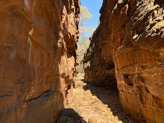
I came back to Blue Gum Flat, a short way from last night's camp, and turned onto Kingfisher track which was a wide dirt road through dry bush, acacias and pines. I had good views towards the southern peaks. It was warm but not hot and the sky was all blue. I stopped for lunch at Kingfisher campsite which was in a huge clearing with a water tank. I started to parallel red walls again, crossed Alligator Creek and reached Hidden campsite, and picked a spot across a creek from the red rocks.
16 kms


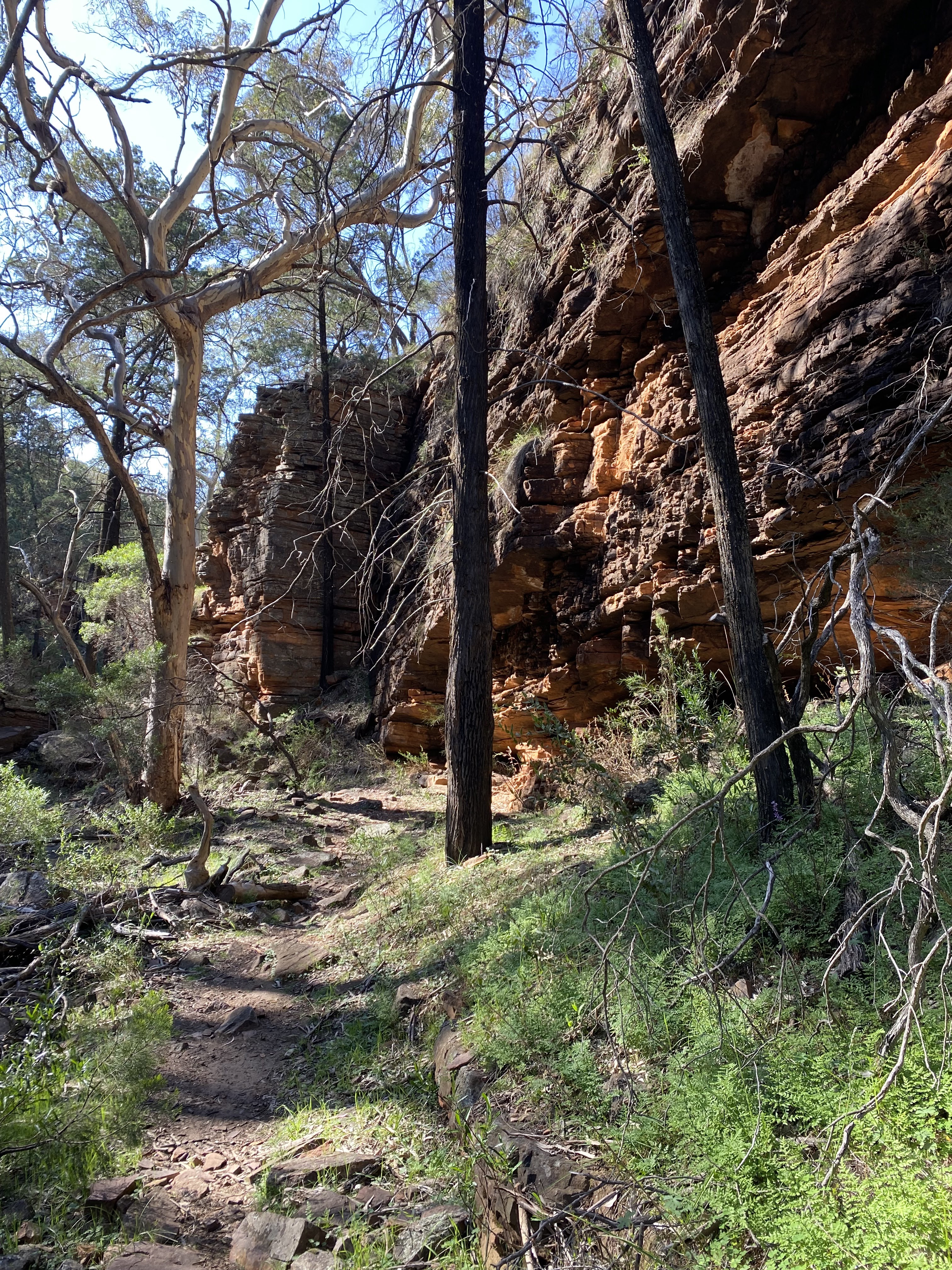
The walls became higher and although I was in shade the cliffs shone bright red in the sunshine. The going was rocky and sometimes I walked in the creek. At the Terraces the creek descended on rock slabs. There was more water here and minuscule cascades between the slabs. I went up to the car park to get water and then sat by the creek for morning tea. After that I walked through the Narrows on Alligator Creek where, at one point, the sides of the gorge were only slightly more than my arm span apart.

I came back to Blue Gum Flat, a short way from last night's camp, and turned onto Kingfisher track which was a wide dirt road through dry bush, acacias and pines. I had good views towards the southern peaks. It was warm but not hot and the sky was all blue. I stopped for lunch at Kingfisher campsite which was in a huge clearing with a water tank. I started to parallel red walls again, crossed Alligator Creek and reached Hidden campsite, and picked a spot across a creek from the red rocks.

16 kms
September 9 I set off into Hidden Gorge and straight away I was surrounded by high cliffs. 
The going was rocky, some creek walking on rocks and slabs. It was impressive, such high sides to such a small creek. There was a huge rockfall to negotiate and many tree/rock obstacles.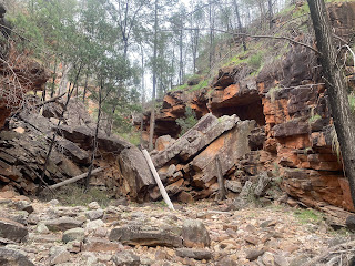
The rock walls became lower and then I was climbing out of the gorge on a scrubby hillside. I came to a tower just as it started raining lightly. I took the walking trail down towards Mambray Creek; at first it was along a ridge with constant views over farmland and Spencer Gulf, the park peaks were partly in cloud. Then the final descent among pines to my car. There were a pair of emus in the car park to greet me. 11 kms

The going was rocky, some creek walking on rocks and slabs. It was impressive, such high sides to such a small creek. There was a huge rockfall to negotiate and many tree/rock obstacles.

The rock walls became lower and then I was climbing out of the gorge on a scrubby hillside. I came to a tower just as it started raining lightly. I took the walking trail down towards Mambray Creek; at first it was along a ridge with constant views over farmland and Spencer Gulf, the park peaks were partly in cloud. Then the final descent among pines to my car. There were a pair of emus in the car park to greet me. 11 kms
Total 55 kms
September 10. I couldn't come to this park without going up Mt Remarkable, especially as I had barely seen it, so I parked in Melrose and embarked on a loop hike. So as not to repeat myself I started with the southern summit trail and returned on the northern summit trail (which is the Heysen). Both trails were similar with views over Melrose, farmland and distant peaks on the eastern horizon. Lower down the trees were sparser giving better views. The trails crossed numerous vast scree slopes of smallish red rocks.
From the highest point on the southern trail I had a couple of kms in forest as I followed the ridge to the main peak (960 m). There's still not much of a view from the summit but descending the northern trail I initially had views towards Spencer Gulf and the hills I hiked in the past few days.
16 kms

From the highest point on the southern trail I had a couple of kms in forest as I followed the ridge to the main peak (960 m). There's still not much of a view from the summit but descending the northern trail I initially had views towards Spencer Gulf and the hills I hiked in the past few days.

16 kms