I booked a place to walk the Heaphy Track and the Old Ghost Road at the top of the South Island, with a short hike that I hoped would work out to fill the days in between.
14 February I got the shuttle bus to the start of the Heaphy Track by Brown River in Kahurangi national park. After only 5 minutes walking I stopped at Brown hut to make coffee. The day's walk was all gradual climbing in the forest, nice on this hot day, ferny and green, cabbage palms, beech. Good window views as I climbed high above the river looking towards the Mt Olympus massif. The trail crossed several flowing streams and I stopped by one at the half way point.
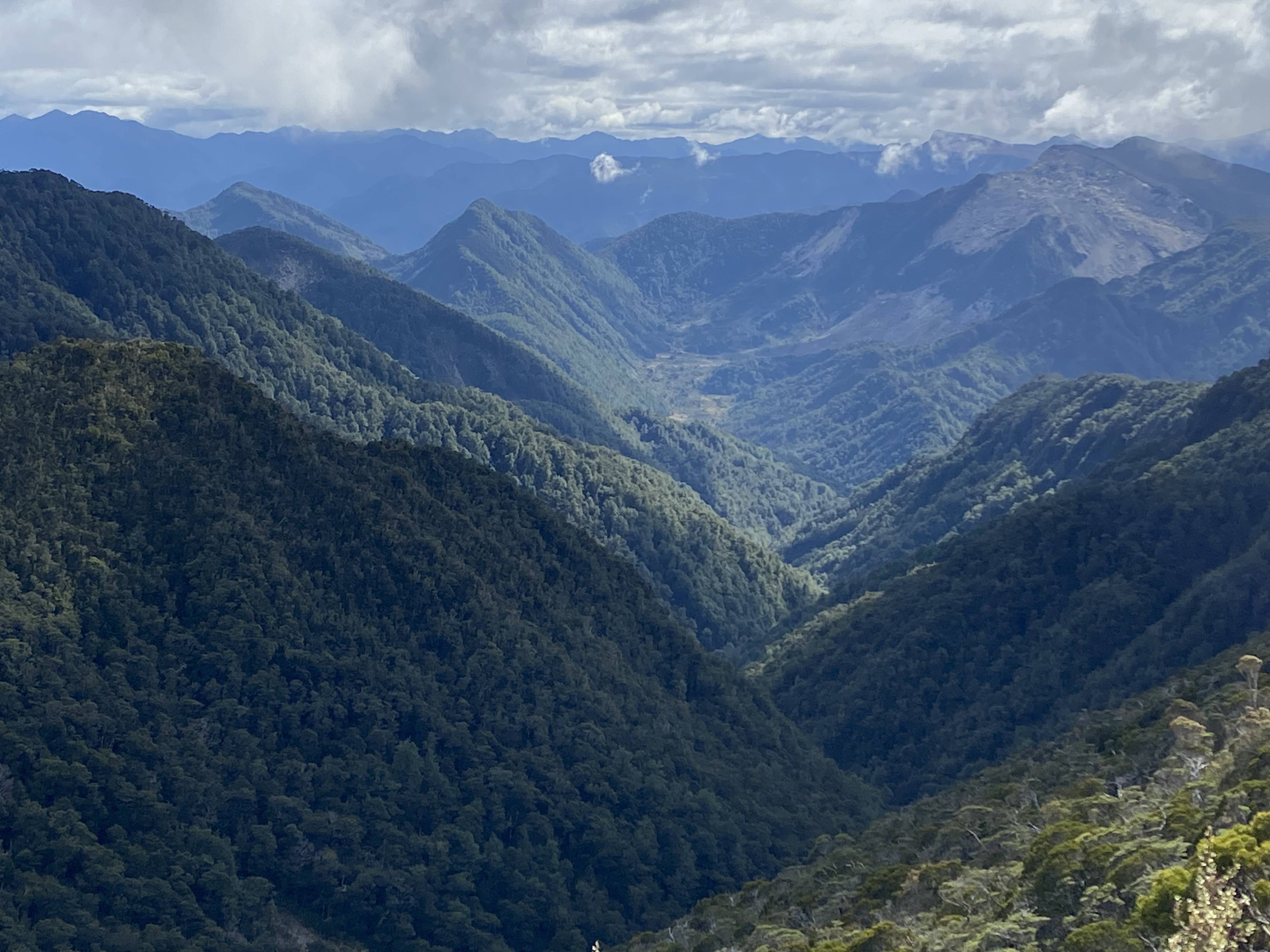
I stopped again at Aorere shelter (a robin for company) and soon after reached the high point of the trail, Flanagans Corner (915 m); nearby was a fabulous lookout over the mountains.
It wasn't far to Perry's Saddle hut/campsite (wekas hanging around). Lots of sandflies.

It wasn't far to Perry's Saddle hut/campsite (wekas hanging around). Lots of sandflies.
I had a break then embarked on the climb up Mt Perry; it was nice to walk without my pack but this wasn't the easy stroll I was expecting. After a stretch in goblin forest I had a narrow overgrown path then loose scree and finally big rocky chunks, but it was great at the top (1238 m) with so many tree covered mountains in every direction, the coast and the hut a dot far below.

The descent wasn't too bad. Still and starry night. 20 kms
15 February Soon I was on the very beautiful Gouland Downs, an area of reddish tussock grass, flax, low manuka and heather hemmed in by mountains. Several wide bridged creeks. Robins and wekas. I had coffee at the hut and went on into forest for slight climb to Saxon hut for another coffee. Little swallows. No takahe.
Another climb in forest: ferns, cabbage palms and beech with nice little creeks but no views for ages, then patches of the golden tussock and boardwalk (reminiscent of Tasmania south coast track). Clouds came and a few drops of rain. There was a stretch with huge boulders.
I descended towards Mackay hut/campsite, the vegetation changing. From the veranda I could see all the way down the valley to the Heaphy River mouth, tomorrow's destination, and to the south a long mountain range. The wekas came right up to my tent. 24 kms
16 February A prolonged downhill in the forest, really peaceful and quiet. After a couple of hours there was suddenly a series of amazing views of the Heaphy River with its gravelly shores far below and mountains beyond. 
The trail came down to Lewis shelter overlooking the river.

The trail came down to Lewis shelter overlooking the river.
Then a pair of suspension bridges across the Lewis and Heaphy rivers and a huge old rata tree on each side of the second bridge. The trail was beside the river, not always in sight, and crossed other minor rivers. There were plenty of wekas in the forest scavenging around and masses of nikau palms (a falling frond made a big din). The trees came to the edge of my bank of the river but on the other side were white pebbly beaches. I saw a rare blue duck (whio). The river widened. Near the end I saw a couple sitting by a creek and they said there was a cave there; I walked through the creek water inside a low limestone cave that appeared to stretch back a long way, dripping, rocky floor and stalactites. I ate lunch by the creek.
Heaphy hut/campsite was on the estuary with a wide sandy beach full of washed up driftwood; the hillsides covered with nikau palms gave the impression of being on a South Sea island. It was hot and while it was windy the sandflies were bearable - until I went to the beach to watch the sun set over the ocean. Good sunset. Great to hear the surf in the night. 20 kms
17 February I went along the track to Heaphy Beach, long wide expanse of sand, and walked along the beach, lucky to find a way back to the trail because the beach was backed by dense flax.
Then I stayed on the winding trail through the nikau palms passing the most beautiful beaches
and crossing headlands, could see headlands all the way down the coast. Every hillside was covered with lush podocarp and palms.

Then I stayed on the winding trail through the nikau palms passing the most beautiful beaches

and crossing headlands, could see headlands all the way down the coast. Every hillside was covered with lush podocarp and palms.

After a stop at Katipo shelter (wekas) I continued through this wonderful scenery, the trail now undulating high above the beaches and crossing several waterfall type creeks on swing bridges. There was a great view over long Scotts beach from Crayfish Point 
then a descent to the beach and a climb to a lookout, where I had lunch.

then a descent to the beach and a climb to a lookout, where I had lunch.

I descended to Kohaihai Creek for a final swing bridge, climbed a very steep path to a lookout over Kohaihai beach and came back down to the shelter which marks the end of the Heaphy Track. I intended to camp there but after checking out the beach, walking around a bit and finding it rather an anticlimax, rain, plus the unbelievable sandflies, I got a lift to the campground in Karamea and went to the pub. Very wet night. 18 kms
This hike total 82 kms
18 February Beautiful sunny morning and I headed out along the road to the Fenian Track trailhead. Cows, a few houses, walking towards mountains. I turned into Kahurangi national park to follow beside the Oparara River and reached the trailhead. Only minutes in I met a hiker who said there was a tree down on the trail making it impassable and a DoC guy working on it. I was devastated as the good stuff was all beyond that point and I had just changed my plans from walking this trail in the other direction. I went on up the trail to have a look at the situation; after two kilometres of climbing high above the river in beech forest I reached the fallen tree, branches across the trail and the DoC guy cutting away. I sat there for ten minutes before he noticed me and said I could now walk through. Phew!
I went on up to Maloneys Bluff, granite outcrop and a big sheer drop to the river, then started the caves circuit. The first cave, Miners Cave, had a gaping opening and loads of thick stalactites and a tiny creek running through it, I walked in a little way.
The second was Tunnel Cave which was 80 metres long and I had to walk through it; there was a sort of path over the rocks inside but also two small drops and it was tricky with my pack. I took it off and lowered it to the cave floor at the first drop so I could get down myself. There was a bend in the cave at the drop and after turning I was relieved that I could see the exit in the distance. The creek running through the cave was shallow. The track to the last cave over Cavern Creek was a real obstacle course of mud, tree roots and awkward steps, this cave was full of water. After this circuit I went on and found a lovely spot by the Fenian River, very shallow with tiny sandy beaches, for a break. A hiker appeared and we had a chat.

The second was Tunnel Cave which was 80 metres long and I had to walk through it; there was a sort of path over the rocks inside but also two small drops and it was tricky with my pack. I took it off and lowered it to the cave floor at the first drop so I could get down myself. There was a bend in the cave at the drop and after turning I was relieved that I could see the exit in the distance. The creek running through the cave was shallow. The track to the last cave over Cavern Creek was a real obstacle course of mud, tree roots and awkward steps, this cave was full of water. After this circuit I went on and found a lovely spot by the Fenian River, very shallow with tiny sandy beaches, for a break. A hiker appeared and we had a chat.
I turned onto the Oparara Valley Track in beautiful forest, beech, ferns, moss and had a lovely winding trail over creeks and along the shrunken Oparara River, at one point there was a difficult fallen tree to negotiate and some fantails watched my struggle. I got to Sunshine Flat shelter in a little clearing, view of 1200 metre peaks, and a robin was very attentive all evening. A weka turned up. I put up my tent in the shelter and the forecast showers were not long in coming, another wet night. 17 kms
19 February I continued along the track, more bridges, the trees happily dripping, and soon the rain stopped. I came to the Moria Gate, an enormous archway accessed via a cave, the wide river flowing through, thick stalactites. 

Then Mirror Tarn, a black pool that had become detached from the river and lived up to its name.
Further on I dumped my pack and walked along the river to the Oparara Arch, an even bigger arch/cavern/tunnel over the river, 200 metres long and 40 m wide.
Lastly I walked to Box Canyon Cave which had no water, a huge cave with tiny side tunnels and completely black inside. I returned to the car park and got a ride back to Karamea. 13 kms This hike total 30 kms


Then Mirror Tarn, a black pool that had become detached from the river and lived up to its name.

Further on I dumped my pack and walked along the river to the Oparara Arch, an even bigger arch/cavern/tunnel over the river, 200 metres long and 40 m wide.

Lastly I walked to Box Canyon Cave which had no water, a huge cave with tiny side tunnels and completely black inside. I returned to the car park and got a ride back to Karamea. 13 kms This hike total 30 kms
22 February I started my Old Ghost Road hike from Gentle Annie on the coast (calm today unlike yesterday) and walked along the road by the Mokihinui River (without seeing it) and crossed the wide river then went through farmland. I walked the old Seddonville railway line, through a tunnel, past a lookout over the river, 
across a swing bridge and ending at a point where one branch of the river went through a tiny gorge.
I reached the Seddonville pub and was irritated to find it closed as I was counting on eating there; luckily someone was there to tell me it would open later. I walked another kilometre to the low key campground with a nice view of forested peaks, some in cloud. Went back to the pub for dinner. 7 kms
23 February A few kilometres out of Seddonville heading towards those mountains I joined the offical Old Ghost Road in Kahurangi national park and entered lovely green forest. The trail climbed high above the Mokihinui River, now much narrower and in a gorge, and undulated along a ledge contouring the hillside, crossing a number of creeks and waterfalls gushing down noisily to the river. Dappled sunshine. There were great views over the river. Tall tree ferns, skinny rimu, beech, robins and a few weka. I had a break by one of the waterfalls.


Then the trail was closer to the river and descended before climbing and passing beneath high cliffs. The river was constantly changing: wide then narrow with rapids; winding or straight; sandy beaches, pebble beaches or vertical banks. At Specimen Point hut where I had booked to camp I met a bike rider and a walker who had recently finished the TA and we chatted for about an hour. A robin sat on my shoe and on my head and was determined to steal some food. The hut was beautifully situated on a bend in the river but I decided to continue on so tomorrow's walk wouldn't be too long.
I had a good view of the Mokihinui widening before dividing at Mokihinui Forks around a big sandbank, backed by higher mountains than before (1300 m plus).
Soon I reached the Forks hut with a view of grassland, bare rock and forested peaks and a sandy fork of the river. Nobody there. Nowhere I could put up my tent so I slept in the hut. 23 kms

Soon I reached the Forks hut with a view of grassland, bare rock and forested peaks and a sandy fork of the river. Nobody there. Nowhere I could put up my tent so I slept in the hut. 23 kms
24 February I left the hut as cloud was lifting over the river.
The trail went away from the river into damper, darker forest, mossy then returned to the south fork, fairly wide and pebbly.
Eventually I crossed this fork on a long high swing bridge although the river was shallow. I detoured to Goat Creek hut, crossing the creek on stepping stones, collected some water and walked uphill into the forest above the creek. Saw/heard a couple of wood pigeons. I stopped to make coffee and three robins came very close to me, but in the end they spent most of their effort chasing each other away; only one stayed.

The trail went away from the river into damper, darker forest, mossy then returned to the south fork, fairly wide and pebbly.

Eventually I crossed this fork on a long high swing bridge although the river was shallow. I detoured to Goat Creek hut, crossing the creek on stepping stones, collected some water and walked uphill into the forest above the creek. Saw/heard a couple of wood pigeons. I stopped to make coffee and three robins came very close to me, but in the end they spent most of their effort chasing each other away; only one stayed.

I had a very long gradual climb, mainly in forest but with patches of grass, with great views back the way I came; it got tough near the top with the hot sun. Lots of bikes. The top of the pass came with little fanfare and I began descending, looking for somewhere to get water and stop; it was all really dry. Out of the forest I had a view down this new valley with two small lakes in a scrubby bowl. 
The trail went below high rocky peaks passing huge scattered lumps of rock and crossing several scree slopes. I found a trickle of water and sat under a rock for a break.

The trail went below high rocky peaks passing huge scattered lumps of rock and crossing several scree slopes. I found a trickle of water and sat under a rock for a break.

The rough descent to the lakes had multiple switchbacks, then I crossed a creek and continued descending across grassland and back into beech forest, crossed Stern Creek on a swing bridge and finally reached Stern Creek hut. The tenting area was a meadow beside the creek. 22 kms

25 February Almost all uphill today. I began with a contouring climb in the forest, with two openings to pass under huge granite slabs giving great mountain views. I came around a corner for wonderful views of endless mountains to the south, 
and when I emerged from the forest I was surrounded by mountains. I went up a lot of steps and reached the Skyline Ridge, great views and I could see the hut way up ahead on a mountain ledge.
The trail descended into forest then continued climbing. The forest became more mossy and damp and I stopped at a lovely spot beside a creek. A robin visited but soon lost interest.
and when I emerged from the forest I was surrounded by mountains. I went up a lot of steps and reached the Skyline Ridge, great views and I could see the hut way up ahead on a mountain ledge.

The trail descended into forest then continued climbing. The forest became more mossy and damp and I stopped at a lovely spot beside a creek. A robin visited but soon lost interest.
The last stretch was more switchbacks up to the hut. I passed Ghost Lake in a cirque, green and uninviting, and got to the hut. 
A fabulous setting at 1200 metres looking out over an unbroken line of mountains to the east and a full view of the trail I walked up.

But my pre-booked tent site had been taken and I didn't like the vibe at the hut.

A fabulous setting at 1200 metres looking out over an unbroken line of mountains to the east and a full view of the trail I walked up.


But my pre-booked tent site had been taken and I didn't like the vibe at the hut.
I sat a while then decided to carry on to a shelter only four kilometres further. The walking was above the tree line, along an exposed ridge over the Lyell range passing outcrops, with views westwards and later eastwards. 
The weather was packing in with dark clouds but I was sheltered from the wind. Top Shelter (1271 m) was in a perfect spot opposite rocky peaks among flax and scrub, a few gentians.

Even a pair of wekas hanging out. By early evening it was pouring and I couldn't see a thing. 16 kms

The weather was packing in with dark clouds but I was sheltered from the wind. Top Shelter (1271 m) was in a perfect spot opposite rocky peaks among flax and scrub, a few gentians.


Even a pair of wekas hanging out. By early evening it was pouring and I couldn't see a thing. 16 kms
26 February The sky was clearing when I got up and I had an amazing view of the mountain tops above the clouds.
It was dead quiet and a weka was stealthing around. The cloud came back down and eventually I left the shelter. Soon I was in a goblin forest then descending in mossy beech forest with shafts of sunlight. I saw a lot of hikers and a wild goat. I stopped for coffee by a little trickle of water.

It was dead quiet and a weka was stealthing around. The cloud came back down and eventually I left the shelter. Soon I was in a goblin forest then descending in mossy beech forest with shafts of sunlight. I saw a lot of hikers and a wild goat. I stopped for coffee by a little trickle of water.
I got to Lyell Saddle hut in a small clearing, looking out over a cluster of mountains which gradually revealed themselves. It became very hot. Up above the hut was a lovely spot to see the surrounding peaks and watch the birds: yellow heads, tree creepers, tomtits. 7 kms


27 February My tent was in a cloud overnight. I continued descending with a few window views out of the forest, the mountains were visible but it was cloudy. The trail crossed numerous slips and waterfalls, I could hear Lyell Creek far below and after half way I was back to the large tree ferns, the forest was brighter and no more moss. The trailside waterfalls continued, giving good places to have a break. Lots of bikers and walkers. I detoured to a former gold battery close to the creek and passed the little cemetery, then arrived at the car park at the end of the trail. The sandflies were vicious. 19 kms
This hike total 94 kms