I wanted to combine a south to north bike crossing of Tasmania with visiting some parts of the island that I've never been to. This involved initially heading south from Hobart to Southport along the coast and going north from there, then checking out an unvisited section of the north coast.
16 January I got to Hobart late afternoon and headed for Snug along the Sandy Bay road. Busy and I couldn't take my eyes off the road to check out the views. Leaving Hobart there was a massive hill and then the far side beyond Kingston was decidedly rural. After another climb I was surprised to come to a rough fire trail through bush descending to the water and to a road following the coast of the d'Entrecasteaux Channel to Margate. From there I had a nice gravel bike path to Snug. I ate dinner sitting on the beach at the caravan park, lots of ducks and seagulls. 34 kms
17 January I wanted to stick to the coast as much as I could - very indented - and I began with a big hill and descent in a conservation park on a gravel road. After that the constantly undulating road would briefly go by the water at the bottom of each hill (with a view of Bruny Island) and I was getting sick of the incessant hills; this was more a workout than a scenic ride. I had a coffee in Woodbridge and the traffic lightened.
From Gordon onwards the road was right by the water passing many tiny pebbly bays and one long sandy beach, the bays sheltered by Bruny. There was a cold wind and the water was choppy. The hills became muted apart from one whopper. At the top I turned onto a quieter road and returned to the water with some really pretty sandy bays. I camped at the Cygnet campground, full of visiting cherry pickers. 65 kms
18 January I had a very enjoyable ride by the water, still and sunny; views of Bruny, across to the other side of the Huon River where I would be later on, and towards the ranges west of Hobart. Lots of fruit growing. Brief stop in Cradoc then a busy road into Huonville and the bakery I always go to.
From there I was on the main road via Franklin to Geeveston, alongside the river with a good shoulder. Geeveston was its usual dead self so I decided to continue to Dover as it was such a beautiful day.
I returned via a hilly country road to the main road and turned off onto the Esperance Coast road following the river and then inlets on Esperance Bay. It was a lovely quiet road (so quiet that an echidna was ambling across) with many water views and stretches of bush but the hilliest yet. I was glad to reach the white sandy beach on the edge of Dover and see Mt Adamson beyond set against the blue sky. I went straight to the caravan park and got a spot by the river; now very windy. 93 kms
19 January I went around the shoreline in Dover and got onto the main road for Southport, lined by forest and not too busy. Long hill. Five kilometres from Southport I turned onto a dirt road for a longer but nicer route deep in the forest (saw my first wallaby), stony and I was rattled to bits. Out of the forest I reached the bay, climbed again into forest and came into Southport and its pier and beach. 220 kms from Hobart. I celebrated with coffee at the shop (after an anxious moment when I thought it was closed).
Now I'm heading for the north coast. I went on the main road back to Dover and continued to Geeveston. Nice king ferns in the roadside forest. Constant hills. In Geeveston I went to the One Stop Shop and the Tasmanian Trail campsite. 69 kms
20 January It started raining in the early morning so I packed up quickly and hoped to sit in the bakery but everywhere was closed; Geeveston, already low in my estimation, plummeted further. When the rain stopped I set out for Judbury on the TT. Soon I was climbing into forest, a little respite then an extremely nasty climb that I struggled even to walk up pushing my bike (then I remembered avoiding this track but looking up at it last year). Higher up were some cleared patches then more gradual climbing on a rough trail; the roughness was getting me down. At the top I came to a better quality gravel road on a ridge with great views of the southwest and soon a very long nerve wracking descent. I had lunch at the park/TT campsite by the Huon River in Judbury and called it a day. 28 kms
21 January Today's ride to Bushy Park looked horrific on the map - two huge hills and nothing else, but I could avoid an unrideable section of the TT. The first climb was tedious, in forest with no view and constant climbing. Then a bone-jarring descent to Plenty River (where I was about to rest when a big group turned up) and soon an even prettier creek where I made coffee. The second climb was ok, more rolling and with little clearings. Near the top I had mountain views northwards and the more open descent passing very young pine plantations was smoother. Black cockatoos. Out of the forest I joined another road for the last part, descending further in a wooded gorge and headed for the Bushy Park roadhouse, same baking hot weather, same lunch of pie, slice and coffee (instant offered with an apology) as last year's visit and, amazingly, same day! 56 kms
22 January I sat at the roadhouse while it rained lightly. Much cooler day, strong wind mostly from behind. Crossed the Derwent River and had a nice ride through rolling countryside, grassy, with an especially good section on a gravel road. Some views of mountains around the central plateau. Came to Bothwell and booked a room at the pub. Cute compact town with old buildings. 50 kms
23 January Grey day, almost light drizzle. I started my climb onto the central plateau on the A5. It was rolling at first then I had steep Shannon Tier; I met a cyclist with his dog on the back of his bike for a long chat at the top. It was bushland from here, a short level section then Bakers Tier. At the top (actually it wasn't yet the top but I thought at the time that it was) I checked out the Steppes rocks with metal sculptures of wildlife and had a coffee break in the clearing at the Steppes homestead cluster of timber huts. Once out of the bush and crossing the plains on the plateau it was freezing and I was riding into the wind. I turned onto a lesser road and had one more stiff climb (a double header) before reaching the Arthurs Lake roadhouse. I had a long break there; a cyclist showed up who was fed up with the TT and we had a good chat. Then I went off the bitumen to the lake, went past my campsite from last year to a different one at Jonah Bay (initially on a road of shale chips that was hard to ride) and picked a spot right at the water's edge. Rained a little in the night. 60 kms

24 January Cold. I returned to the bitumen road (saw several wallabies) and continued climbing for many kilometres until I was right beneath Mt Blackwood. I had glimpses of the Great Lake. Quite suddenly I was on the edge of the plateau, green farmland far below, distant Western Tiers and some very sheer cliffs to each side of me. I had about 12 kilometres of continual winding descent at a pleasant grade and the road to myself. There were little waterfalls beside the road. At the bottom I passed the Poatina power station and tail race pipe coming almost vertically down the cliff face. I turned off for Poatina hydro village and a lovely cafe.
A little more descending then I was riding past cabbage fields and other crops. The cliffs of the plateau looked formidable behind me. The roads became long and straight and it was hard going into the wind. I stopped at Cressy and watched the wind pick up becoming very gusty. The last stretch to Longford was unpleasant on a busy road with minimal shoulder and a crosswind blowing me towards the traffic. I found a side road for the last bit and headed for the bakery and then the campground by the river. 73 kms
25 January I crossed the river out of Longford and had a nice rural road for half the way to Launceston. Then I went on the highway which had a good shoulder until the final scary descent into Launceston where the shoulder vanished. Went to my usual maccas in Launceston.
Long climb out of Launceston which continued when I turned onto the hilly Bridport road. When I got to the top of the first range I went onto a nice gravel road heading into the bush but after only three kilometres a sign said no through road; I asked a passing driver about this and she said the road on my map was blocked off with no outlet from where I was. So I returned to the bitumen, had a good descent to farmland and started on a gravel road shortcut to get off the busy road. This featured a completely unrideable hill and at the top, where I could see the main road far below and some forested peaks, I talked to someone outside his house; he said this was also a no through road but wondered if I could get through on a bike, and fortunately I found a rough track which I could walk down. Then I remained on the main road, it went through denser bush and passed newly replanted hillsides and was much quieter, a real roller coaster and making this a hard day. I reached Pipers River and was surprised to find a shop, nothing else.
I was on a busier road for a while before turning onto a bush lined gravel road to the metropolis of Lefroy (10 houses max) and finally a narrow sealed road to Beechford. The hills continued to the very end. I walked out to the crescent of sandy beach backed by dunes: the north coast. It was extremely windy. The campground shown on my maps appeared to have been built on but I found a spot out of sight behind some bushes (with an ocean view and I could hear it). 92 kms

26 January I had breakfast overlooking the beach, much less windy but a grey day. Then I took a back road to George Town on the eastern side of the Tamar River passing scrubby grazing land and low hills. I came upon an open cafe and had a long break, also booked a room.
I took an easy ride out to Low Head and the lighthouse, going along the Tamar estuary. I just happened to be there for the weekly sounding of the restored foghorn (after 30 blows, three at a time, it got a bit old). 
The weather had become hot and sunny and the views of the sandy beaches along the north coast were good. 32 kms

The weather had become hot and sunny and the views of the sandy beaches along the north coast were good. 32 kms
27 January I left George Town on the highway, went onto a lesser but busy road and onto a lovely quiet road through grazing cow country with low hills around, one valley across from my route to Pipers River. It was raining lightly and a bit misty. This joined a busier road until I turned onto a gravel road and finally the highway to the Batman bridge across the Tamar. From high up I had good views of the wide river and at the top of one hill I stopped for blackberries. I made coffee at the picnic area under the bridge, which was high and long.
On the other side I was on a road right by the river and then climbing inland a couple of whopper hills to a ridge with vineyards, Western Tiers on the horizon. It got sunny. Long descent to Beaconsfield where I sat for a while. Last section to Beauty Point (big marina and little else) and the very quiet campground was a welcome return to the Tamar on an off road path. Then in the late afternoon I went back to Beaconsfield, with several stops for blackberries, to buy food, as there is no shop on my route between there and Port Sorell. 72 kms
28 January Beautiful day. Not far out of Beauty Point I turned onto a gravel road going into the forest of the coastal range; it was lovely riding with ferns and a creek and climbing. The last part was too steep to ride and at the top there was a burnt out car and no view. The descent was long and horribly corrugated and native pine, drier. At the bottom I met a cyclist on his fifth lap of Tasmania.
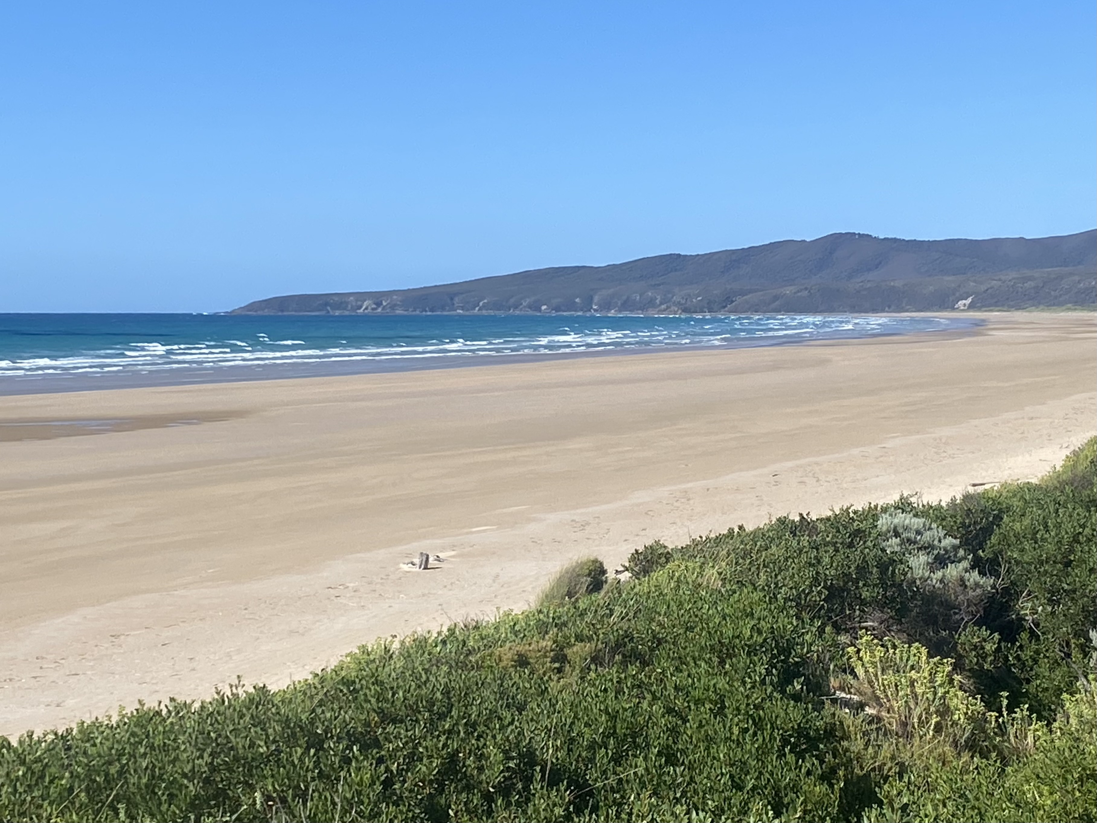
Soon I was in Narawntapu national park crossing scrubby ferny land. I checked at the visitor centre that the campsite near the beach had water and rode there, into an awful headwind. This beach was on the Rubicon River estuary looking across to my next destination Port Sorell. There were four taps but no water. Someone gave me water to make coffee and I sat there, while a blue tongue lizard came right up to me and tried to steal a coffee sachet.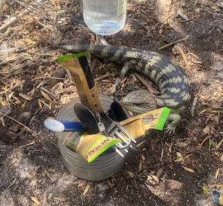

Then I decided to pack up and go back to the campsite at the visitor centre which had water and I had a speedy wind-assisted return. I walked over the dunes to Bakers Beach, a beautiful sweep of sand between the estuary and a headland. It was very hot and I had a restful time sitting in some shade on the dunes reading. 
There were lots of wallabies and native hens st the camping area. 37 kms
There were lots of wallabies and native hens st the camping area. 37 kms
29 January I had a nice ride through rural countryside under the coast range, still hilly, crossed the two arms of the Rubicon River and had a busy road to Port Sorell where I had a scone break.
I went on a bike path along the estuary beach to Shearwater and continued on a road above the water along Hawley Beach which was broken up by orange tinged rocks. I could see across to Narawntapu.
Returning past Port Sorell I found quiet roads through patchwork farmland to Latrobe, very pleasant. 58 kms
30 January Sunny day; it's hard to believe I've had an entire trip to Tasmania without serious rain. I took the Mersey River bike path into Devonport and went around the coast: climbed Mersey Bluff and passed several beaches. Then a bike path west (not flat) alongside the highway, with coast views at top of big hill, to Leith and across the Forth River to Turners Beach. Long beach and a cafe by the highway. I went back to Devonport the same way and on to East Devonport to relax before tomorrow's ferry. 43 kms
Total 864 kms


