Returning to Spain I found a walk route that followed an arc through the Baetic mountains (Cordillera Bética) in Andalusia starting at the Mediterranean and finishing on the Atlantic. Sounded like my thing but I was concerned about the reliability of the guide book and lack of accommodation at the end of some sections so I intended to use a variety of trails and improvise where necessary.
14 November I took the bus from Malaga to Nerja to start my Andalusia coast to coast walk. Once I was out of Malaga there was no sign of there having been a huge rain and flooding event yesterday. In Nerja I walked to the southern edge of the town, to a plaza with a balcony overlooking the Med and views of the mountains I would be heading into. I chose this to be my start line.

I walked through the town, passing some fairly average beaches, crossed some roads and heathland and came into a lovely gorge with high sandstone cliffs and little caves, some dripping. I was climbing gently. Nice birdsong. The day was misty. After 7 kilometres I joined the main trail, GR 249, and climbed more steeply, soon reaching a large picnic area and the Sierra de Almijara. I continued climbing to a pass 
where I looked into another valley, dry tree covered mountains, and then descended steeply, corkscrew like, to a vigorous mountain stream I had to cross. I climbed to another pass, with views across the mountains to Nerja and the sea,
and then a third pass followed by a fourth, both with sea views. The trail was narrow and stony. I came down from the last pass to a dry pebbly river bed and repeatedly crisscrossed it for a while. Suddenly I could see Frigiliana high above me. I climbed a steep concrete road and I was in the centre of the village, houses all white and perched on the edge of the hillside. There was a huge deck area with cafes overlooking the terraced hillside and the road down to the coast. 19 kms

where I looked into another valley, dry tree covered mountains, and then descended steeply, corkscrew like, to a vigorous mountain stream I had to cross. I climbed to another pass, with views across the mountains to Nerja and the sea,

and then a third pass followed by a fourth, both with sea views. The trail was narrow and stony. I came down from the last pass to a dry pebbly river bed and repeatedly crisscrossed it for a while. Suddenly I could see Frigiliana high above me. I climbed a steep concrete road and I was in the centre of the village, houses all white and perched on the edge of the hillside. There was a huge deck area with cafes overlooking the terraced hillside and the road down to the coast. 19 kms
15 November Perfect blue sky so I wanted to set out early; I walked around the village for over an hour looking for somewhere open to get breakfast, and came across the striped brick church. At 9.15 I found a cafe just opening and within a minute it was full.
I walked along the road out of Frigiliana by mango and olive trees and agriculture in the valley, then turned onto an access road through pine forest to the lost and now restored village of Acebuchal. At a turn in the road I saw the village, small and tucked below high mountains. I stopped for coffee. 

I descended through the valley then turned north and headed up a pine filled ravine with a noisy stream I couldn't see. At the head of the ravine I turned back up the other flank, having to jump across the stream. I walked on this side until I was back above a much larger cultivated valley and tried to navigate my way to Cómpeta. Some of it was a complicated rough track but I had lovely views over the valley. Finally I looked down on Cómpeta with white buildings and a distinctive brick church tower, and I descended the steep narrow streets to the church and main square. Swordfish for dinner. 17 kms

16 November I walked out of Cómpeta along a road flanked by olive and avocado trees on a path that was like a balcony overlooking the valley and Canillas de Albaida. I passed a small chapel, went through the town and had a zigzagging stony path down to the Rio Cajula which I followed, repeatedly crossing it on planks of wood.
Then I climbed away from the river into the Sierra de Tejeda, Almijara y Alhama and came onto scrubby hillsides where I was surprised to meet a couple walking. Shortly after I found myself scrambling through thistles when the path disappeared; after climbing to a ruined building as instructed and seeing no way out I gave up and scraped my way over to a path I could see across the ravine. (I knew those walkers must have found a way through.) This path went through olive groves with views across to my ruin, which looked better from a distance, 
and I reached the main trail again. I was soon on a ridge with views across to the white houses of Sedella and I crossed a high pass. Now the walk was cruisy along the ridge, gradually descending. I left the ridge for a track initially along a water channel then descending towards Sedella with great views of high mountains, scrubby, and the bare granite face of La Maroma to the north.
The descent spiralled steeply and roughly to the river until I could see a gorgeous single arch Roman bridge.
I crossed the bridge and walked up into Sedella at 2pm. There were several cafes on the small square but nowhere to get any food. 16 kms

and I reached the main trail again. I was soon on a ridge with views across to the white houses of Sedella and I crossed a high pass. Now the walk was cruisy along the ridge, gradually descending. I left the ridge for a track initially along a water channel then descending towards Sedella with great views of high mountains, scrubby, and the bare granite face of La Maroma to the north.

The descent spiralled steeply and roughly to the river until I could see a gorgeous single arch Roman bridge.

I crossed the bridge and walked up into Sedella at 2pm. There were several cafes on the small square but nowhere to get any food. 16 kms
17 November Sedella looked pretty in the early morning light as I climbed above it and started my long ascent towards La Maroma in the Sierra Tejeda. 
At first I was on a wide dirt track then I came onto a narrow rocky path. I stopped at a spring beside a sheet of granite. The view towards the face of the mountain was amazing and I could see a very long stream I would be crossing.
Soon I was having trouble staying on the overgrown trail as it descended into the first of many ravines and I became worried, but I found it, and then met some hikers who said the path was in better condition where I was heading. I also felt better once I could see the path winding along the mountainside ahead. I got to the big stream, one of several where I could get a drink, and spent hours climbing in and out of ravines and valleys (some had active streams, others had dry stream beds) and contouring the mountainside.

At first I was on a wide dirt track then I came onto a narrow rocky path. I stopped at a spring beside a sheet of granite. The view towards the face of the mountain was amazing and I could see a very long stream I would be crossing.

Soon I was having trouble staying on the overgrown trail as it descended into the first of many ravines and I became worried, but I found it, and then met some hikers who said the path was in better condition where I was heading. I also felt better once I could see the path winding along the mountainside ahead. I got to the big stream, one of several where I could get a drink, and spent hours climbing in and out of ravines and valleys (some had active streams, others had dry stream beds) and contouring the mountainside.
I went over one pass, then another at 1420 metres, and through a couple of notches between rocks, and as I began descending the path was lined by pines - with the ground covered in pine needles it was easier to walk. From the top I could still see the Med. I started to get views to the west over several valley villages and a reservoir, and mountain ranges in every direction. It felt odd to see houses and roads yet be somewhere so remote. I undulated along and was pleased when I saw I was on a signed trail and then I saw walkers ahead of me on the trail which was reassuring. I had a very long descent on hairpins, passed big outcrops, and emerged above Alcaucin, which I had not seen at all from high up, then walked into the village and had a plate of chips. There was a nice 5-spout tiled water fountain and a white church on a tiny square, and the usual steep streets. 
18 kms

18 kms
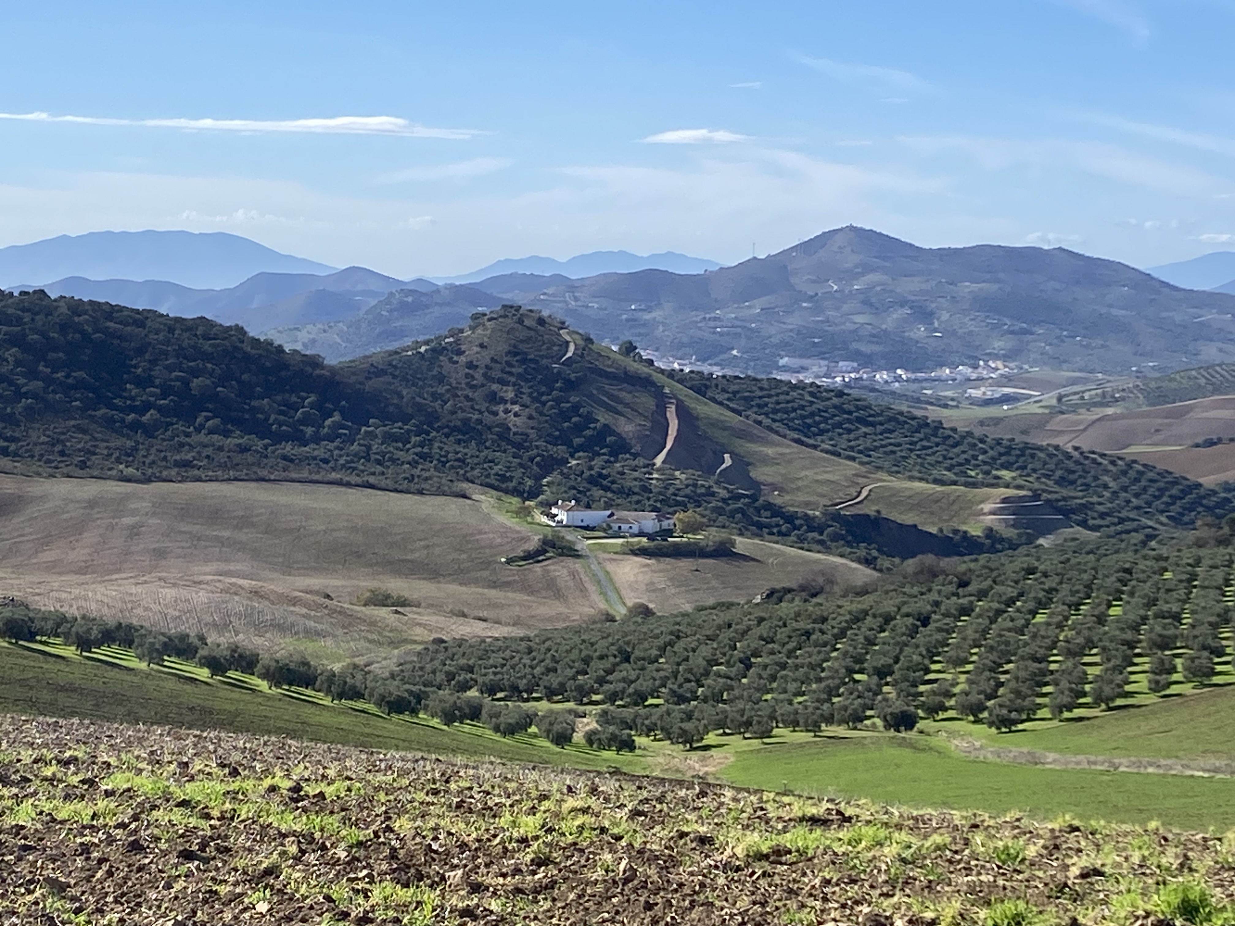
18 November I made up my own route to Riogordo and it was successful although I had some anxious moments. Dogs were barking at me all day. I descended to the valley floor, great views of a ruined castle, rugged mountain faces, olive groves and scattered white buildings. I passed a lot of orange trees full of ripe oranges and stopped in Puente de Don Manuel at a cafe full of English people.
Then I was on a busy road for a while, turned onto a minor road heading for a river crossing I was unsure about. I got to the river and paddled across easily but had difficulty finding my trail on the other side, got stuck in thistles and ended up on a different trail. I followed the next trail until it evaporated and walked up through an olive grove to the main road. Great views to the north west of mountains with bare rock faces and to the southwest hazy blue tiers of mountain ranges. I tried some alternative trails which were muddy and hilly, and decided that walking along the road was fine. When I was still a few kilometres from Riogordo I stopped at a petrol station (dominated by an impressive mountain) for a snack, as I was exhausted, then descended into the town, really tucked into the valley. A big flock of goats was being herded along the dry river bed.
I had a coffee on the square and asked if the bar was open for dinner, the guy said yes, what time would you like; google said they were closed on Mondays, maybe that's why I ended up eating there alone. 23 kms
19 November A breakfast toasted sandwich in the bar where the locals were guzzling brandy. I climbed past ploughed fields and through olive groves (trees full of ripe olives) on a wide track, then a road stretch; where I turned off the road I was surprised to find an open bar so I stopped.
Next a muddy farm track passing bare fields and olives, climbing until I reached the main road, where I went on climbing. From the road there was a view in all directions: the peak Peña Negra right there, La Maroma distant but still looking huge, and ranges southwest. Later on I could also see the El Torcal massif ahead. Also a town and farmhouses. And olive groves.
I had over an hour of road until I turned off for Villanueva de Cauche, a small village that is apparently unchanged since the 17th century. A cute place with just three streets (cafe closed) but badly positioned next to the motorway. 
I was worried my hotel/restaurant down the road would also be closed and I had no food. So I rushed on, adjacent to the motorway, to the hotel beside it. Open. I was hungry and had no choice but to have the rather average menu del dia for lunch. 18 kms

I was worried my hotel/restaurant down the road would also be closed and I had no food. So I rushed on, adjacent to the motorway, to the hotel beside it. Open. I was hungry and had no choice but to have the rather average menu del dia for lunch. 18 kms
20 November Easy day. I set off on a dirt road in howling wind and cloud all around so I couldn't see anything that was higher up. The trail climbed past bare fields and olives and I had a glimpse of my destination Villanueva de la Concepcion lower down in sunshine. Once I started to descend I had good views to distant mountains to the south. I was now on an 18th century historic route that ran between Madrid and Malaga; three of the original elaborate bridges remained, two in stone and one of red bricks. I passed several farmhouse ruins and saw goats being herded down a hillside. It was sheltered here and the sun came out and I got to see this side of El Torcal.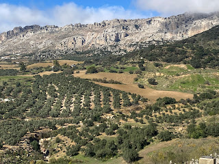
I climbed the hill into the town and hoped it wouldn't be too quiet; a woman directed me to a bar and it was busy. Then I had lunch on a square in the sun, but the wind was still cold. 14 kms

I climbed the hill into the town and hoped it wouldn't be too quiet; a woman directed me to a bar and it was busy. Then I had lunch on a square in the sun, but the wind was still cold. 14 kms
21 November I chose to walk a section of the Camino Mozárabe to Antequera. I left V de la Concepcion in sunshine and walked below the blocky face of El Torcal for several kilometres, 
then turned north and suddenly I was going into an extremely strong wind and the mountain was being engulfed in cloud. I was climbing in farmland and then contouring low slopes of the mountain with grass and boulders and unusual karst formations. I passed a farm just before the highest point on the trail and came to the Puerto de la Escaleruela, a strange area of eroded karst limestone (on the ground and outcrops and a peak I could just about make out) and - I read - a view to Antequera and its surrounding mountains. It was freezing cold. The trail descended very steeply and soon I could see Antequera in the distance and a patchwork of farmland and neat farmhouses directly below. The wind was gone.
I came down rapidly through this rugged terrain, at the bottom a farmer held his sheepdogs at bay as I passed, and had a cruisy stroll to Antequera. As I approached the town I had great views of the castle looming above the old town and the curiously shaped rock Peña de los Enamorados.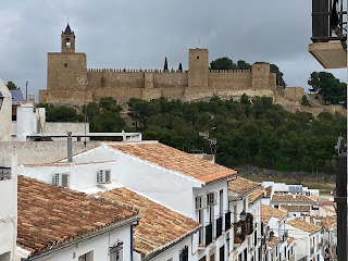
I stopped at the first bar I saw to get warm, with a perfect view of the castle.

then turned north and suddenly I was going into an extremely strong wind and the mountain was being engulfed in cloud. I was climbing in farmland and then contouring low slopes of the mountain with grass and boulders and unusual karst formations. I passed a farm just before the highest point on the trail and came to the Puerto de la Escaleruela, a strange area of eroded karst limestone (on the ground and outcrops and a peak I could just about make out) and - I read - a view to Antequera and its surrounding mountains. It was freezing cold. The trail descended very steeply and soon I could see Antequera in the distance and a patchwork of farmland and neat farmhouses directly below. The wind was gone.

I came down rapidly through this rugged terrain, at the bottom a farmer held his sheepdogs at bay as I passed, and had a cruisy stroll to Antequera. As I approached the town I had great views of the castle looming above the old town and the curiously shaped rock Peña de los Enamorados.

I stopped at the first bar I saw to get warm, with a perfect view of the castle.
I was able to go inside three churches (keen on emotional statues beneath cupolas full of plaster angels) and looked right at one from my room.
I walked out to the site of two Neolithic (3500 BC) dolmens: Dolmen de Viera which had a corridor and small chamber, and Dolmen de Menga which had a corridor, large chamber divided into sections and a well. Later I toured the Alcazaba with its arched entrance, two towers, double walls, mosque ruins; then the adjacent church (simple round arches) and ruins of Roman baths. I was just too late for the next church, and when I got back to my hotel the church opposite was open: lots of gold-encased statues. I ate tapas in two places, including snails. 22 kms

I walked out to the site of two Neolithic (3500 BC) dolmens: Dolmen de Viera which had a corridor and small chamber, and Dolmen de Menga which had a corridor, large chamber divided into sections and a well. Later I toured the Alcazaba with its arched entrance, two towers, double walls, mosque ruins; then the adjacent church (simple round arches) and ruins of Roman baths. I was just too late for the next church, and when I got back to my hotel the church opposite was open: lots of gold-encased statues. I ate tapas in two places, including snails. 22 kms
22 November A day on the GR 7. A long dull road walk out of Antequera on a grey day, improved when I went onto a dirt road, climbed steeply alongside the Camorro Alto massif which was in cloud yesterday and had other mountain views. Lots and lots of olive trees full of black olives. Lots of barking dogs. I descended then climbed again, crossed a field and reached a dirt road along a ridge with great views west over olive groves and the distant Guadalhorce River. I came down on a winding path going around a conical mountain 
and got a fleeting view over the houses of Valle de Abdalajis before descending more. In one place I had to negotiate a landslide at a stream crossing. The town was hidden until I was right above it and had a huge cliff on one side, the Abdalajis range. 20 kms

and got a fleeting view over the houses of Valle de Abdalajis before descending more. In one place I had to negotiate a landslide at a stream crossing. The town was hidden until I was right above it and had a huge cliff on one side, the Abdalajis range. 20 kms
23 November I climbed out of the town right below the towering blocky limestone cliffs of Sierra de Abdalajis, passing under a huge curving rock face. 
Then an unusual six-basin water trough. Soon there was nature park with grass and boulders and some miniature palms to my right, but farms and farmland to my left and views into the Guadalhorce valley. I came into a more rugged area with outcrops ahead and alongside the high mountains of Sierra de Huma.
Griffon vultures floating around the cliff tops. From the highest point I descended in pine forest passing below the Escalera Arabe where I could see rock climbers really high up. Lots of people were walking up the trail. I had views of the Guadalhorce reservoir surrounded by both green and bare mountains and reached El Chorro village, just a few buildings and a station, surrounded by cliffs. 12 kms

Then an unusual six-basin water trough. Soon there was nature park with grass and boulders and some miniature palms to my right, but farms and farmland to my left and views into the Guadalhorce valley. I came into a more rugged area with outcrops ahead and alongside the high mountains of Sierra de Huma.

Griffon vultures floating around the cliff tops. From the highest point I descended in pine forest passing below the Escalera Arabe where I could see rock climbers really high up. Lots of people were walking up the trail. I had views of the Guadalhorce reservoir surrounded by both green and bare mountains and reached El Chorro village, just a few buildings and a station, surrounded by cliffs. 12 kms
Nothing to do in El Chorro so I got the train to Álora 15 minutes away and visited the Arab castle remains. The castle was high above the town, which was itself on a steep hillside, and featured a tower, a small part of a church and its tower, and some walls. There was a vast view over the countryside and the Guadalhorce River, a trickle here but I could still see mud from the recent flooding.


24 November I went out early to walk up the Escalera Arabe. I cut all the switchbacks from my descent yesterday to El Chorro and turned onto a path contouring the cliffs. Soon I saw a group of ibex snacking on grass and then several more, but they ran off. 

I started on the steps, which were all sizes and right against the cliff, in sections.
I could see limestone outcrops all around and the reservoir below. The steps (maybe 200) finished and with a bit more climbing I was on a plateau with a farmhouse, and the 200 metres higher cliffs of Pico de Huma behind. It was very beautiful with today's absence of cloud.
I decided to return the same way rather than continue the loop through the forest. I could see griffon vultures hovering around the cliff tops as I descended. 8 kms


I started on the steps, which were all sizes and right against the cliff, in sections.

I could see limestone outcrops all around and the reservoir below. The steps (maybe 200) finished and with a bit more climbing I was on a plateau with a farmhouse, and the 200 metres higher cliffs of Pico de Huma behind. It was very beautiful with today's absence of cloud.

I decided to return the same way rather than continue the loop through the forest. I could see griffon vultures hovering around the cliff tops as I descended. 8 kms
In the afternoon it clouded over. I went to walk the Caminito del Rey. I was gobsmacked by the number of people - a group of thirty starting every ten minutes. After walking to the start along that Guadalhorce River (brown from the heavy rain ten days ago) I joined my group and went into the Gaitanes gorge. Immediately the path hung off the gorge wall, 100 metres above the river, where the gorge was only seven metres wide. 
The gorges were the best parts where the path was cantilevered out along the gorge wall, looking across the gorge to the railway line (many tunnels and viaducts) and the amazing 300 metre high cliffs on the other side, often gouged with caves and hollows.


The derelict original path was often right under the new one. Near the end was a suspension bridge high above the river, parallel to a pipe. The route finished at a huge snacking area. 8 kms
25 November GR 249 today, which is usually well marked. I climbed up above El Chorro on a narrow rocky path right under cliffs, across the reservoir from the town, and reached a dam wall. Then I followed a ridge with a fabulous view across to the area I walked yesterday: the plateau with farmhouse and cliffs of Sierra de Huma and the Gaitanes gorge.

A little further on I was pleased to get a view of the Bobastro 9th century ruined Mozárabe church far below - the site was closed today. Then I noticed a track going straight down the mountain to some signboards so I scrambled down and helped myself to a tour of the rocky ruins: a couple of arches, low walls, some deep cavities and a few columns. 
I tried to leave via the official entrance but there was a locked gate and I had to scramble back up the hill.

I tried to leave via the official entrance but there was a locked gate and I had to scramble back up the hill.
A long stretch winding upwards along a ridge with views into green valleys either side, and I came across sheep being herded along my road. Then the route suddenly went on a rough stony track and into pine forest with sand underfoot. I passed chapel ruins and a shrine and it started raining lightly. I emerged from the forest above Carratraca, white houses and a prominent yellow town hall and tower; next to the town hall was a pretty terraced garden with orange trees. My first stop was Casa Pepe restaurant to see if my room booking done with help from the receptionist in Antequera had worked - it had! I had lunch at this Carratraca institution: gazpachuela, chicken drumsticks, chorizo and chips, flan. It was a nice little village with some grand buildings that had seen better days when it was a spa resort, and an occasional sulphurous smell. 18 kms

26 November The other side of Carratraca faced a new mountain range, Sierra de Alcaparain. 
I climbed past scattered houses and orchards of oranges, lemons and pomegranates, and helped myself to two oranges from an unfenced tree.

I climbed past scattered houses and orchards of oranges, lemons and pomegranates, and helped myself to two oranges from an unfenced tree.
Then I was up in pine forest, more climbing as I contoured around the mountains seen earlier. I took a slight detour and my reward was finding dozens of goats sheltering by a low cliff. 
Soon after I came onto a ridge with an extraordinary view over all the mountains I've walked by, from La Maroma to El Torcal to La Huma and even a shining sliver of the Med; it was quite unreal to see this vast area of ridges and valleys and I wasn't that high up, 700 metres. I returned to forest, passed a disused marble quarry (could see the veins in the exposed marble) and had a few kilometres on the road.

Soon after I came onto a ridge with an extraordinary view over all the mountains I've walked by, from La Maroma to El Torcal to La Huma and even a shining sliver of the Med; it was quite unreal to see this vast area of ridges and valleys and I wasn't that high up, 700 metres. I returned to forest, passed a disused marble quarry (could see the veins in the exposed marble) and had a few kilometres on the road.
I turned off to walk right under Sierra Prieta on a minor path, limestone rock with pinnacles to one side and farmland below. 

The path petered out and my route was supposedly marked by cairns; I didn't see many of these but I was able to follow goat tracks - literally. It was rugged country: the mountains, outcrops, scree, and rocks lying everywhere. The second time I had a stretch where the cairns couldn't be seen, below Sierra Cabrilla, the goat tracks didn't last long and I got very confused. I had noticed in the distance a man standing by a van on a ridge between fields; after a time of me bumbling around I heard him yelling El Burgo, El Burgoand gesticulating, so I walked over to him through the thistles and he showed me a dirt trail near where we were standing, which was my route. Then I had a long descent to El Burgo on a concrete road passing olive trees and finally crossing the Turón River (clear water) on a single arch Roman bridge. The town was quiet and I walked the whole length to find a bar. 23 kms


The path petered out and my route was supposedly marked by cairns; I didn't see many of these but I was able to follow goat tracks - literally. It was rugged country: the mountains, outcrops, scree, and rocks lying everywhere. The second time I had a stretch where the cairns couldn't be seen, below Sierra Cabrilla, the goat tracks didn't last long and I got very confused. I had noticed in the distance a man standing by a van on a ridge between fields; after a time of me bumbling around I heard him yelling El Burgo, El Burgoand gesticulating, so I walked over to him through the thistles and he showed me a dirt trail near where we were standing, which was my route. Then I had a long descent to El Burgo on a concrete road passing olive trees and finally crossing the Turón River (clear water) on a single arch Roman bridge. The town was quiet and I walked the whole length to find a bar. 23 kms
27 November I had all my meals at the same bar in El Burgo. I crossed the Turón and had a nice walk alongside it, then climbing gradually through a gorge, pine trees on my side and high cliffs of the Sierra des Nieves with circling vultures on the other side. It was freezing cold but I knew I would get very hot once the sun hit me higher up. I could hear the river but not see it until further up the gorge where it became gravelly and eventually dry. After a lookout over the Valle de Lifa and the ruins of Torre de Lifa on a rocky hilltop I descended steeply to cross the dry river bed and climbed out crossing little grassy terraces. Some lovely autumn leaf colours. 

The path, now narrow and stony, steepened and I had sweeping views back to the gorge, across the rocky valley and to high rocky walls. It felt quite like wilderness until I reached a plateau with a farm. I had to cross some fields and pass the sheep enclosures, where a barking dog crawled under a fence to sniff at me (but nothing worse). More climbing on a farm track brought me to a pass at 1169 metres.


The path, now narrow and stony, steepened and I had sweeping views back to the gorge, across the rocky valley and to high rocky walls. It felt quite like wilderness until I reached a plateau with a farm. I had to cross some fields and pass the sheep enclosures, where a barking dog crawled under a fence to sniff at me (but nothing worse). More climbing on a farm track brought me to a pass at 1169 metres.
I descended on a dirt road, all around very green, and could see Ronda in the valley. Once I reached the valley floor I could no longer see the town and it seemed hard work walking for a couple of hours past ploughed fields with nothing to look at. Coming into Ronda was not impressive: just boring appartments and busy roads. 27 kms
Once I walked around the old town I enjoyed the place more: the Puente Nuevo straddling the deep gorge is certainly spectacular, lots of churches, grand buildings, the Roman bridge, town walls and archways.


28 November I checked out the Arab baths and saw the third of the bridges and left Ronda at midday. I walked across the Puente Nuevo and descended a steep cobbled path down the gorge to the river, getting good views of the bridge and stopping to look at the waterfall on the way. 
Once at the bottom I walked through the valley beside the sheer cliffs that the town sits on top of, and headed towards another mountain range.

Once at the bottom I walked through the valley beside the sheer cliffs that the town sits on top of, and headed towards another mountain range.
I crossed a railway line and started climbing into the Sierra de Grazalema. The path got steeper and steeper until I reached a pass with giant agaves and a view ahead of strange karst limestone peaks;
a few metres beyond there was a chapel Ermita de la Escarihuela and the amazing sight of a semicircular ridge above Montejaque.
I descended to the town, tucked into these weird mountains, on a pristine cobbled path. As I walked through the town, passing the exhibit of the former wash house, I was disappointed to see that absolutely everything was closed. The shops opened at 5 but nothing else. 12 kms

a few metres beyond there was a chapel Ermita de la Escarihuela and the amazing sight of a semicircular ridge above Montejaque.

I descended to the town, tucked into these weird mountains, on a pristine cobbled path. As I walked through the town, passing the exhibit of the former wash house, I was disappointed to see that absolutely everything was closed. The shops opened at 5 but nothing else. 12 kms

29 November The village square was lively early. I climbed out of the village on a gravel road and was soon surrounded by the very eroded limestone mountains. Then a brief descent to reach the grassy Libar valley hidden in these mountains, with lots of massive holm oak trees and free roaming cows.
It was peaceful and took a couple of hours to cross, with just one farmhouse at each end. The climb out of the valley was on a rocky/stony single track but easy to follow, crossing several grassy terraces, and I reached a pass; the view into the next, tiny, valley was breathtaking for the sheer size of the mountains around it.
The path contoured above this valley (which had a farmhouse in one corner) and climbed to get above a narrow deep gorge. Once I was past the gorge I began my descent to Cortes de la Frontera, which looked like a big place from above. The rough path corkscrewed down, merged into a road, and then the last part was a no messing around slippery path dropping straight into the houses. I stopped at the supermarket and then the first bar (next to the bullring), just to be sure of getting fed. I popped inside the large church and saw the elaborate town hall. 20 kms

It was peaceful and took a couple of hours to cross, with just one farmhouse at each end. The climb out of the valley was on a rocky/stony single track but easy to follow, crossing several grassy terraces, and I reached a pass; the view into the next, tiny, valley was breathtaking for the sheer size of the mountains around it.

The path contoured above this valley (which had a farmhouse in one corner) and climbed to get above a narrow deep gorge. Once I was past the gorge I began my descent to Cortes de la Frontera, which looked like a big place from above. The rough path corkscrewed down, merged into a road, and then the last part was a no messing around slippery path dropping straight into the houses. I stopped at the supermarket and then the first bar (next to the bullring), just to be sure of getting fed. I popped inside the large church and saw the elaborate town hall. 20 kms

30 November Started out a ho-hum day and became something special. I had a long downhill from Cortes, stopping at Casa de la Piedra where a chapel (who knows?) had been carved out of a lone outcrop with rooms, wells, niches, steps. 
I came to the railway line and went through a 2 kms long but narrow village bordering it and then passed farms.

I came to the railway line and went through a 2 kms long but narrow village bordering it and then passed farms.
Then the good part. I crossed the Rio Guadiaro and began climbing above it until I was contouring the cliffs as the river entered Cañon de las Buitreras. Further on the gorge narrowed dramatically and from a lookout I could see the narrow river (turquoise water) and railway line between high cliffs. 
I even saw a train go in and out of the tunnels on the far side of the gorge. The path stayed high for a while then descended very steeply to a bridge across the gorge where the walls were almost touching and went into a tunnel through the rock with steps where I had to crouch.
Next a long steep climb to a lookout where I had a good chat with two Belgians.
The sight of the tiny river far below was amazing. Then an even steeper descent back to the river with a lookout half way down; the river was widening slightly, the cliffs still extremely high. Finally I walked close to the river's edge, with little pools, gravel beaches and rapids, and I had a chat with a Spanish family. My only real conversations of the walk so far. As I exited the gorge I could not imagine where El Colmenar could be because all I could see was forested hillsides. The village appeared suddenly and was completely dominated by the station (not even El Colmenar but called Gaucin) which split the place in two. 17 kms

I even saw a train go in and out of the tunnels on the far side of the gorge. The path stayed high for a while then descended very steeply to a bridge across the gorge where the walls were almost touching and went into a tunnel through the rock with steps where I had to crouch.

Next a long steep climb to a lookout where I had a good chat with two Belgians.

The sight of the tiny river far below was amazing. Then an even steeper descent back to the river with a lookout half way down; the river was widening slightly, the cliffs still extremely high. Finally I walked close to the river's edge, with little pools, gravel beaches and rapids, and I had a chat with a Spanish family. My only real conversations of the walk so far. As I exited the gorge I could not imagine where El Colmenar could be because all I could see was forested hillsides. The village appeared suddenly and was completely dominated by the station (not even El Colmenar but called Gaucin) which split the place in two. 17 kms
1 December I was pleased to find a lively bar open early on a Sunday morning. The mountain tops were in cloud so I felt ok with my decision to walk the Via Serrana at the edge of the Alcoronales nature park. I began by crossing the Guadiaro, now just a normal river again, and climbing through a field then on the road then a dirt road. It was an unpleasantly muggy day and misty. From the highest point I could see San Pablo de Buceite ahead and Jimena de la Frontera beyond, nicely lined up together. I descended to a hamlet where the road was lined by avocado trees and later oranges and crossed the river again.
San Pablo had a large central square where I had coffee - it's been ages since I could have a coffee in the middle of my walk - and continued on some sort of ancient right of way that went between fences. Completely out of the blue I had to climb an embankment and cross the railway line.
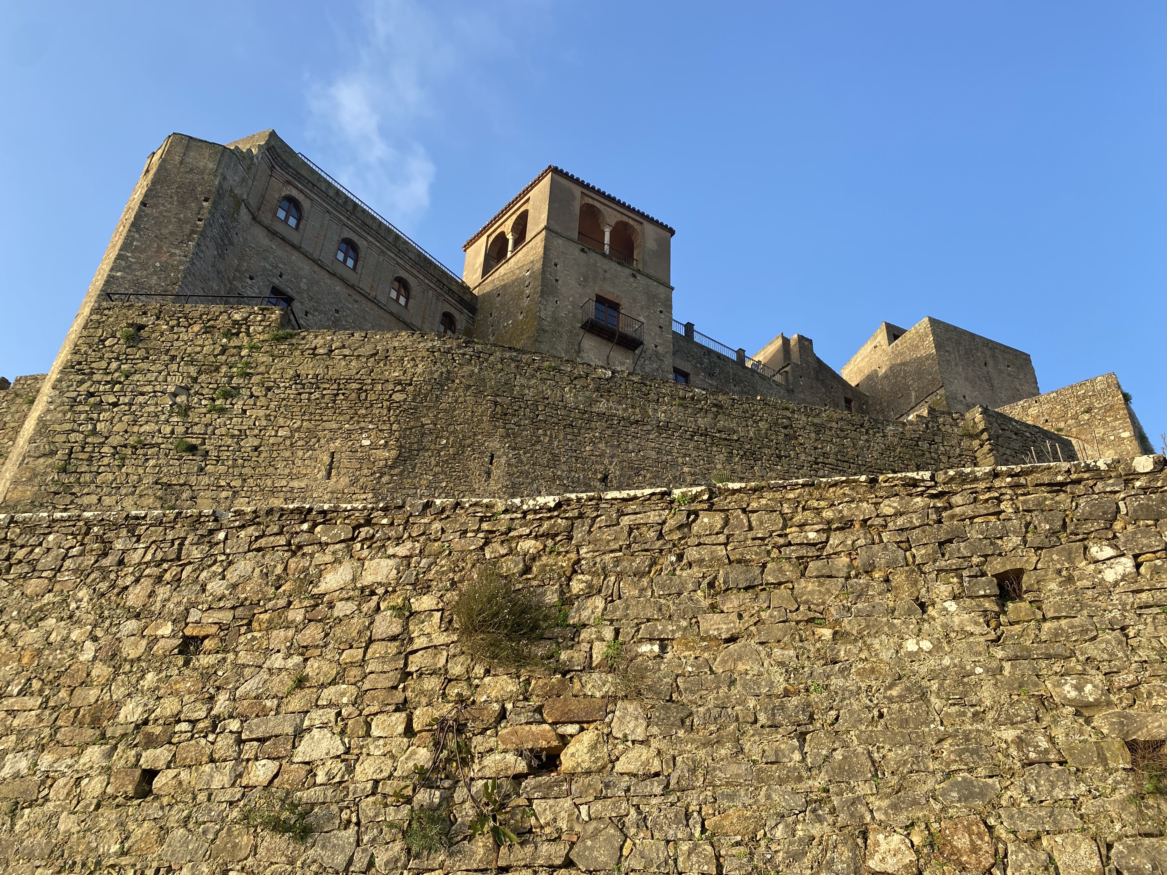
More of the little used path and I reached Jimena: tiered white houses and parts of a castle at the top; the usual narrow streets but with the footpaths slimmed down so the cars could race around. 
I looked at a church and found my hotel with a view back over the valley I crossed. Then I had lunch of asparagus with scrambled eggs and ham. I walked around the castle ruins covering a large area - with a round tower, gateway, lots of walls to ruined buildings. The mountains beyond looked especially rugged. In the evening I sat in the square by a Moorish bell tower. 20 kms
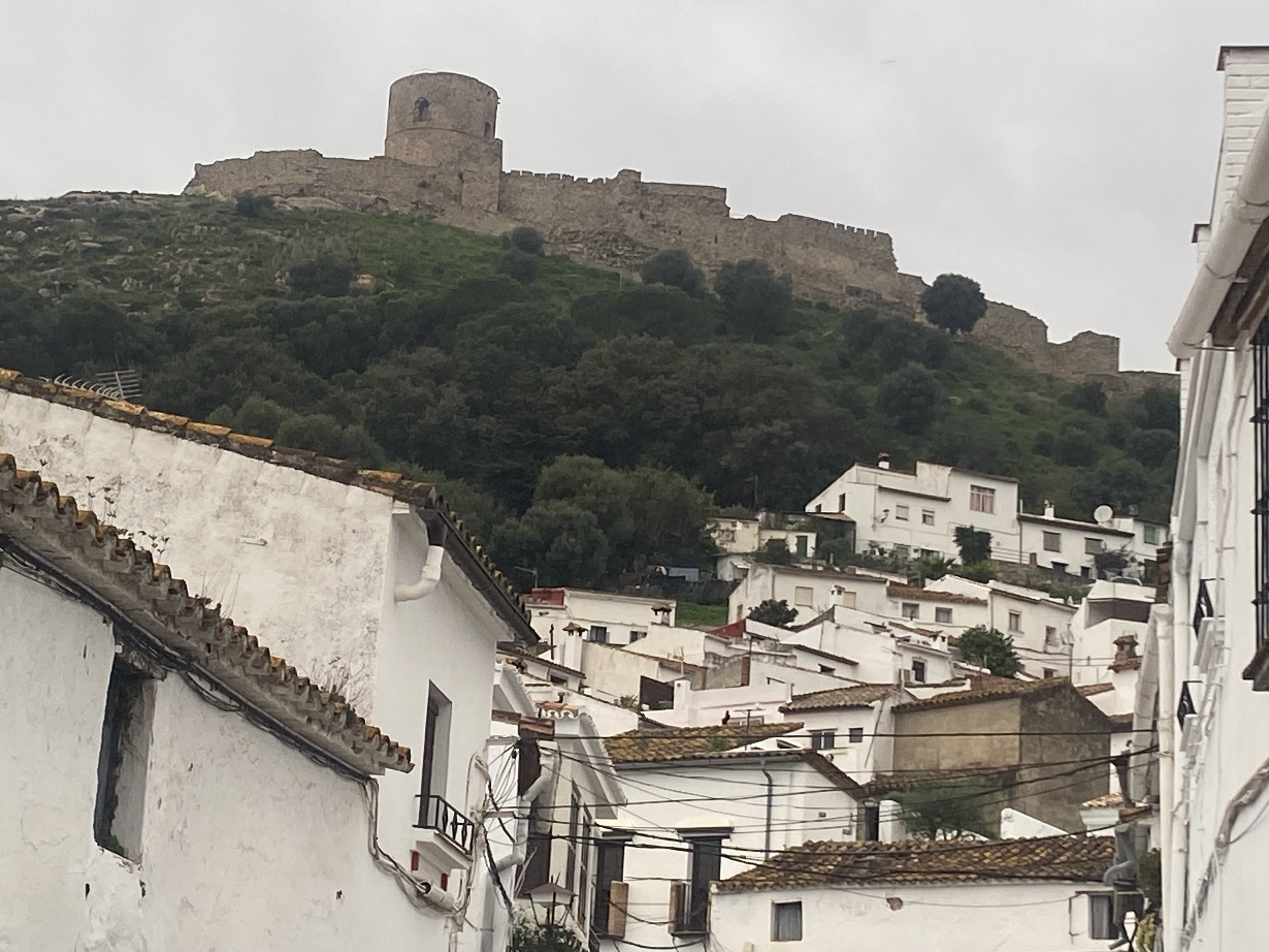
I looked at a church and found my hotel with a view back over the valley I crossed. Then I had lunch of asparagus with scrambled eggs and ham. I walked around the castle ruins covering a large area - with a round tower, gateway, lots of walls to ruined buildings. The mountains beyond looked especially rugged. In the evening I sat in the square by a Moorish bell tower. 20 kms
2 December This was an uninteresting day and again muggy but by compensation I ended up staying in a castle. I walked for hours alongside the railway line by ploughed fields, the track often muddy, and all completely flat. I forded a river a few times. I had a break at a level crossing before leaving the railway line and I was treated to a train passing.
The track doubled back on itself and when it resumed forward progress I had a glimpse of my castle on a hilltop. The trail became rocky and climbed alongside hills of cork trees which had been left to go wild. From higher up I could see a hazy Rock of Gibraltar. I reached Castillon de Castellar: the castle looked very impressive in being intact, and the hotel entrance was in a castle courtyard. From my room in the castle I looked out over the day's walk; the fields, hedges and trees were pretty from here. The compact white village of Castellar de la Frontera was inside the castle walls. 21 kms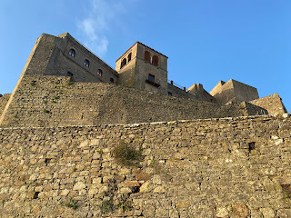
3 December Blue sky, not muggy. I started with walking downhill from the castle on a Roman cobbled track then followed a road passing cork trees. At the end there was a cork processing plant with sheets of cork piled up. Next I had the worst part of the whole route: over an hour on a tarmac bike path separated by concrete bollards from a major road and dense blackberry on the other side. Then suddenly the most extraordinary sight of the route: a section where storks had built nests on top of all the electricity pylons (and in some trees) and were either sitting there making a din or flying around.


I got to a roadside restaurant (of several, the first that was open) so I had coffee.


I got to a roadside restaurant (of several, the first that was open) so I had coffee.
I had another long stretch of road but more pleasant as there was no traffic and the road wound around green hills. I left the road for a track along a sandy ridge with views over Los Barrios below and huge mountains beyond; half way along there was an illegible signboard about some dwarf palms so I stopped, and when I looked the other way I had my first good view over the bay of Algeciras and Gibraltar.
I descended to Los Barrios and walked to a square with a church with a stone tower (not white) and orange trees and had a sandwich. I went into the centre then got the bus to Algeciras. 25 kms

I descended to Los Barrios and walked to a square with a church with a stone tower (not white) and orange trees and had a sandwich. I went into the centre then got the bus to Algeciras. 25 kms
4 December Day trip to Ceuta, a pocket of Spain in Africa. The best part was on the ferry seeing two continents at the same time. I walked around the town, walked along a pebbly beach and checked out the fortress walls.
5 December I took the bus to La Linea de la Concepcion, passed through immigration and walked across the Gibraltar airport runway into Gibraltar. On to the city centre where I had churros for breakfast, ordered in Spanish from habit and paid in pounds. I walked along a road to the start of the Mediterranean Steps which go up to the southern peak of the Rock; the steps were surprisingly steep but immediately gave great views over the entire area including the Spanish coastline west of Malaga, the massif of Jebel Musa in Morocco, the eastern side of Gibraltar with beaches, the densely developed western side and Algeciras bay. I stopped at a cave and the route went through a tunnel. At the top (426 metres) I looked around a gun emplacement which still had all the gear. I descended a bit and checked out the views at the top of the cable car and some other fortifications and I was going to leave the summit area by the steps of the Charles V Wall but I was jumped on by monkeys who were sitting on the steps and I quickly went back up. This was a blessing in disguise since I ended up seeing heaps more stuff. 


I looked at many more caves, tunnels and fortifications (some with canons and some without); toured St Michael's Cave which was a vast cave with stalagmites and stalactites; a display about the siege in the 1770s; the WW2 network of tunnels; the 1333 Moorish castle tower. I was worn out after that. I traipsed down steps into the city, returned across the runway to La Linea and had to take two buses to get back to Los Barrios to resume my main walk. The main square in Los Barrios was really buzzing, a nice change from all those quiet evenings. 16 kms
6 December I left Los Barrios and was soon on a dirt track heading towards the Parque Naturale Alcoronales, first passing fields and then into the mountains. I went close to a ruined tower on a hilltop and passed a lake. The trail climbed gradually for hours and I could see a line where a river flowed far below. I cut some switchbacks by going deeper into the forest on rocky paths and I emerged at a lookout with an amazing panoramic view over the bay, La Linea and Gibraltar. The Med was the most beautiful blue. Everything was still. I continued on a ridge with this view then went into pine and cork forest with views of extensive forest covered mountains instead. 
There were plenty of mountain bikers on the trail. I met a Spanish couple walking who seemed to be locals and I asked them about the highway part of my route today. When I reached the highest point the trail turned due south and I had an unobstructed view across the Strait of Gibraltar towards Jebel Musa and the Rif mountains in Morocco: tiers of mountains rising above a strip of heat haze.


I descended with some sheep until they took a shortcut that was too steep for me, and after a while reached the highway.
From here I wanted to go directly to my hotel which was on the highway. The road was busy but I managed to cross it and walked mostly behind the crash barrier. For the final few minutes I went onto a side road and I was almost done when I passed some houses and heard a dog barking; suddenly this large dog rushed towards me and jumped up at me so forcefully that I fell over backwards, hard. I sat there in shock. Meanwhile the dog had disappeared; I told the owners what happened and they apologised. Luckily the hotel was very close and very nice. 24 kms
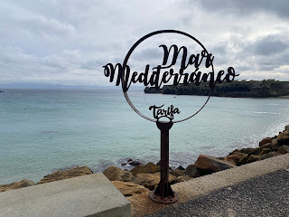
7 December I had to walk along the highway some more but it was ok and I had some nice views over the hills and the Strait. Then I turned onto a deserted road for a long descent to the coast, walking directly towards the Strait but it was a cloudy day so the views into Morocco weren't so clear. Down at the coast I undulated on a narrow track on low cliffs past cows grazing. At sea there were rock platforms all along. On the hills were ruins of sentry boxes (lookouts for smugglers). I had an early glimpse of the Tarifa lighthouse. Just before Tarifa the path went inland and on returning to the coast (still the Med) I had a proper view of the town with its castle.
I walked into the old town and had churros to celebrate.

I walked into the old town and had churros to celebrate.
I walked out of the centre and along the beachside path by the Atlantic Ocean for a couple of kilometres. Cold and windy. Then I returned on the sand and went on the causeway that separates the Med from the Atlantic, leading to Tarifa Island, most southern point in Europe. 
The gates to the island were locked so I had to turn back here. I returned to the town and when I arrived at the Cafe Central I decided my walk was done. 20 kms


The gates to the island were locked so I had to turn back here. I returned to the town and when I arrived at the Cafe Central I decided my walk was done. 20 kms
Total 444 kms