I'm partial to a coast walk so the Camiño dos Faros in Galicia appealed to me, with lots of beaches and lots of cliff top walking. Could be very wet which wasn't so appealing. The logistics of the early days gave me a challenge.
14 October I took a bus from A Coruña to Carballo and another to Malpica for the trail start. I had intended to wait a day before starting out but I walked to the lighthouse (#1) at the far end of the little port, turned around and commenced my Camiño.
Starting a day early messed up my planning but there was nothing to do in Malpica, although it was a pretty place with colourful buildings stacked on the hillside. I crossed over to the ocean beach promenade above a sandy beach, full of noisy gulls. I detoured to my hotel to check in and leave my bag, and had a second breakfast at the only open cafe.

Starting a day early messed up my planning but there was nothing to do in Malpica, although it was a pretty place with colourful buildings stacked on the hillside. I crossed over to the ocean beach promenade above a sandy beach, full of noisy gulls. I detoured to my hotel to check in and leave my bag, and had a second breakfast at the only open cafe.
I walked along the beach promenade and then climbed onto a gorse/fern covered hillside. It was a grey day, pleasant walking temperature. The path was fairly close to the cliff edge, passing little beaches and rocky coves and I could see the coastline was very indented. Soon I saw the Sisargas islands (with lighthouse #2). There was a distinct ocean smell. Temporarily it felt remote, then I could see a wind farm and a village on the coast ahead. I descended to the little beach at Beo and back up to the road on a staircase that was still under construction. I took a minor road back to Malpica through crop fields. 13.4 kms
15 October I left Malpica in intermittent rain with a last look at the beach 
and returned to Beo via a different set of villages, rejoining the trail at a lovely bay.
I stayed on the low cliffs until descending to a sandy beach where I had to wade through a little creek. I walked along the beach and climbed through the scrub to a contouring path with a view of yesterday's coastline under low cloud. All too soon I rounded the point and arrived at today's destination, an isolated pensión. I was the only person staying there and in the evening I ate my peppers stuffed with cod alone in the restaurant, with a fabulous view out over the ocean. 8.5 kms

and returned to Beo via a different set of villages, rejoining the trail at a lovely bay.

I stayed on the low cliffs until descending to a sandy beach where I had to wade through a little creek. I walked along the beach and climbed through the scrub to a contouring path with a view of yesterday's coastline under low cloud. All too soon I rounded the point and arrived at today's destination, an isolated pensión. I was the only person staying there and in the evening I ate my peppers stuffed with cod alone in the restaurant, with a fabulous view out over the ocean. 8.5 kms
16 October It was raining when I got up and the pensión owner was gloomy about the weather and said I would be cutting my walk short but it wasn't bad at all. I left as soon as it was light at 8.30 and headed past the scattered houses, crossed a white sandy beach and climbed over a saddle to another bay, then the real walking began. I climbed on a rough rocky trail to the cliff top and undulated along with the ocean on one side and bracken fern covered hillsides on the other with large boulders. There was a bit of scrambling. The weather was already improving. I got a glimpse of Punta Nariga lighthouse (#3) and had a long series of ups and downs to reach it. 
After that the going was easier along a rocky stretch of coast. I came to Niñons beach, then crossed an even prettier beach and more followed.

After that the going was easier along a rocky stretch of coast. I came to Niñons beach, then crossed an even prettier beach and more followed.
The trail went inland into trees, crossed another beach and became steeply undulating with amazing views up and down the rugged coast. After a while I could see Punta Nariga lighthouse again and all the coastline I had walked, in nice sunshine. It was tiring though, constantly climbing up a headland then descending to cross a stream or rocky bay and I was glad to reach the little village of O Roncudo. I ate lunch by a couple of the local barns on stilts (horreos).
I left the trail, walked steeply down the road to Corme, had coffee and asked the barman to call me a taxi; the driver took me to Ponteceso and then helped me check in to my hotel as the owner wasn't around. 21 kms
17 October Taxi to Corme then I walked back up to cliff top O Roncudo along gravel roads and tracks, and reached the trail as the sun came out. It was windy and the water was rougher. The path contoured the grassy/ferny hillside with big boulders and Roncudo lighthouse (#4) came into view beyond some more inlets. 
It was a low lighthouse in a wonderful setting. I rounded the point on a path through the boulders and walked on the road into Corme, with views across the large bay to Laxe. I stopped for coffee in Corme which was much livelier than yesterday.

It was a low lighthouse in a wonderful setting. I rounded the point on a path through the boulders and walked on the road into Corme, with views across the large bay to Laxe. I stopped for coffee in Corme which was much livelier than yesterday.
I left Corme via two small beaches, a bit of damp forest and a lovely white beach, before returning to a fairly level path ten metres above the water. Corme was more attractive from a distance: steeply layered colourful houses. The trail stayed low until reaching vertical cliffs where I had to climb to the windy top for a great view and then a descent in eucalyptus forest to a beautiful beach. I crossed the beach and walked a low headland. At the end was a huge estuary and massive sand dunes. The trail wound between the dunes and pine forest then reached the estuary edge and followed it to Ponteceso, the last part on a levee between the river and wetlands. 20 kms
18 October I crossed the bridge over the Anllóns River, went uphill for a view over the estuary and came down for an hour of nice walking beside the river. It rained but soon cleared.
The trail makes a big inland detour and I was unsure whether it was worthwhile but I'm glad I did it. I walked alongside a fast flowing stream in oak forest, climbing gradually, turning off for the track to the Castro de Borneiro which was quite a surprise: hidden in the forest were the remains of lots of circular stone houses dating from 200 BC. 
A kilometre further on I visited the Dolmen de Dombate, a burial mound comprising big stone slabs, roof and corridor from 3600 BC. I went through the next village and climbed in pine forest to the top of Castelo de Lourido, 312 m, with views across the bay of the coast from Roncudo lighthouse to Ponteceso (including the cliffs I had climbed which looked impressive from this side) and to Laxe, a large town on a white curving beach.
The many hills inland were misty. The descent was long, first forest then a series of villages (plenty of horreos) all very quiet. I was almost back where I had been hours ago.

A kilometre further on I visited the Dolmen de Dombate, a burial mound comprising big stone slabs, roof and corridor from 3600 BC. I went through the next village and climbed in pine forest to the top of Castelo de Lourido, 312 m, with views across the bay of the coast from Roncudo lighthouse to Ponteceso (including the cliffs I had climbed which looked impressive from this side) and to Laxe, a large town on a white curving beach.

The many hills inland were misty. The descent was long, first forest then a series of villages (plenty of horreos) all very quiet. I was almost back where I had been hours ago.
I walked out to the coast and passed two lovely beaches 
contouring through ferns, and climbed to the top of a couple of promontories. I could still see Roncudo lighthouse and Corme all the way. The first time I saw Laxe again it looked close but wasn't. The trail rounded more inlets keeping fairly high then I came into civilisation abruptly and walked along the Laxe promenade behind the dunes. Biggest distance I've walked since January. The old town had narrow streets and an austere 14th century church I was able to go inside. 25 kms

contouring through ferns, and climbed to the top of a couple of promontories. I could still see Roncudo lighthouse and Corme all the way. The first time I saw Laxe again it looked close but wasn't. The trail rounded more inlets keeping fairly high then I came into civilisation abruptly and walked along the Laxe promenade behind the dunes. Biggest distance I've walked since January. The old town had narrow streets and an austere 14th century church I was able to go inside. 25 kms

19 October It was pouring when I got up but improved to misty rain. I went up the road to Laxe lighthouse (#5) but there was no view. I took the trail right by the water around some rocky ribs and passing an oceanfront cemetery, then climbed to the grassy/bouldery top of the next headland. The view from the top was a real gem: a curve of white sand ahead, 
the Laxe peninsula and Laxe beach behind.
I was happy to get the views despite the misty day. I took off my rain clothes. The descent was nasty as the rocks were wet but I was able to walk the beach I had seen.

the Laxe peninsula and Laxe beach behind.

I was happy to get the views despite the misty day. I took off my rain clothes. The descent was nasty as the rocks were wet but I was able to walk the beach I had seen.
More coastal paths with the coastline visible back a very long way, then a dirt road between the ocean and pine forest. Another long beach but the trail went behind it to give access to a wetland and lagoon. This ended at a village with a bar so I went in for coffee. The bar was busy with men drinking red wine and eating anchovy sandwiches.
The path continued alongside the beach, rounded a few points and I came to an area filled with weird boulder formations; I had nice glimpses of colourful Camelle arranged along the west side of an inlet.
I had my introduction to flooding on the trail. The next kilometre was in pine forest and very flooded. I came into Camelle and had another coffee in the port area. Then around two more bays to Arou with a tiny sandy beach and I got there as the rain returned. 19 kms

I had my introduction to flooding on the trail. The next kilometre was in pine forest and very flooded. I came into Camelle and had another coffee in the port area. Then around two more bays to Arou with a tiny sandy beach and I got there as the rain returned. 19 kms
20 October The wind was crazy in the night. As I walked to the cafe for breakfast I could see the Laxe lighthouse flashing. I left Arou in light rain - very pretty looking back 
and started around some bouldery inlets including a climb with a tricky descent on the wet rock. I came to a huge vegetated sand dune I had to skirt on a sandy track, passing lovely beaches.
I came over a headland and noticed two friendly dogs were following me; they stayed right behind me for a kilometre then vanished. This was all slow going and the trail was again flooded. I reached the walled English cemetery with memorials to sailors from the 1890s and then had my first sighting of the Cabo Vilan lighthouse (#6). It has a spectacular setting at the tip of a promontory with big rocks off the end.

and started around some bouldery inlets including a climb with a tricky descent on the wet rock. I came to a huge vegetated sand dune I had to skirt on a sandy track, passing lovely beaches.

I came over a headland and noticed two friendly dogs were following me; they stayed right behind me for a kilometre then vanished. This was all slow going and the trail was again flooded. I reached the walled English cemetery with memorials to sailors from the 1890s and then had my first sighting of the Cabo Vilan lighthouse (#6). It has a spectacular setting at the tip of a promontory with big rocks off the end.

I walked towards the lighthouse on a dirt road with increasingly great views, as the sun came out, 
until the setting was no longer apparent and it just looked like a lighthouse on a hillside, so I turned to follow the west facing coast for Camariñas. I could immediately see the Ermita da Virxe do Monte on a cliff top. This coast was windy. I walked an undulating dirt track above rocky inlets, with a view of Muxia across the bay, turning off for a visit to the stone chapel (closed). The trail descended to a so-so beach and went through pine trees. I passed a tiny lighthouse (#7). Even though Camariñas is a large town I couldn't see it until I was right in the port, and I walked along the waterfront as the rain started. It was a bleak wet Sunday evening. I couldn't see anywhere that would be open to eat until I noticed a bar right by my hotel which appeared to have the whole town inside. 22 kms

until the setting was no longer apparent and it just looked like a lighthouse on a hillside, so I turned to follow the west facing coast for Camariñas. I could immediately see the Ermita da Virxe do Monte on a cliff top. This coast was windy. I walked an undulating dirt track above rocky inlets, with a view of Muxia across the bay, turning off for a visit to the stone chapel (closed). The trail descended to a so-so beach and went through pine trees. I passed a tiny lighthouse (#7). Even though Camariñas is a large town I couldn't see it until I was right in the port, and I walked along the waterfront as the rain started. It was a bleak wet Sunday evening. I couldn't see anywhere that would be open to eat until I noticed a bar right by my hotel which appeared to have the whole town inside. 22 kms
21 October it was raining heavily while I had breakfast and I only left town once it stopped; I didn't mind this. I had another large estuary to get around. I went along a wet grassy track, through pine forest, saw a flock of herons. The water was still and black. I stopped for coffee in the first village. Then I walked alongside the River Porto, back in pine forest. I could see men harvesting the bright green seaweed. I went through a large but deserted picnic area and walked a short stretch along the beach - saw a line of cormorants on a rocky ridge in the river - then had another coffee when I got back to the road.
The last part was an exercise in avoiding the main road, going through a couple of villages (one had a horreo sheltering lots of cats) and into a eucalyptus plantation. In sunshine. I returned to the main road and was soon in Ponte do Porto. The town was centred on an old bridge over the river and several places were open, unlike Malpica last Monday. 13.5 kms
22 October I was given a big breakfast, all alone, at the hotel. I crossed the bridge and walked along the river to Cereixo, a village with a church and, nearby, two stone towers. I went a bit inland on the road then soon I descended back to the river for a tranquil walk in forest. I could see Camariñas across the bay. I emerged at an ocean beach, now having left the estuary, 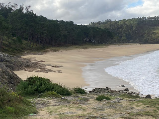
then a tiny lighthouse on a point (#8), followed by another beach that clearly expected crowds in season, with several closed hotels and restaurants. From there I took the road through a couple of villages, hoping for an open cafe but no luck.

then a tiny lighthouse on a point (#8), followed by another beach that clearly expected crowds in season, with several closed hotels and restaurants. From there I took the road through a couple of villages, hoping for an open cafe but no luck.
I was on the road for a while before I came to duckboard through a wetland area and a windswept beach, and I went back into forest. At the highest point I had a sudden glimpse of Muxia in sunshine and I could again see the Cabo Vilan lighthouse (but not so spectacular from here). I came down to the water, with Muxia fully in view, a rocky hill behind the town, and I crossed a final beach, unfortunately getting a wet foot when I met a stream.

Muxia was a shock: it was crammed with people and all the waterfront cafes were full; I went to a bar in a back street which was nicely out of the wind. After going to my hotel I went for a walk around the rocky hill to the Sanctuario de Nosa Señora de Barca, 
fantastic setting on the rocky promontory but unbearably windy, with small Muxia lighthouse (#9) nearby. 22 kms

fantastic setting on the rocky promontory but unbearably windy, with small Muxia lighthouse (#9) nearby. 22 kms
23 October Perfect blue sky for the first time. I road walked out of Muxia then crossed a beach and climbed steeply up Monte Cachelmo. I had a view over Muxia, the bay and as far back as Cabo Vilan. In the forward direction I could already see the Cabo Touriñan lighthouse and many small bays. Then a steep rocky descent, I rounded an inlet and went out to Punta de Buitra, more views in all directions from the summit. 
Blue sea. Blue sky. Not a breath of wind.

Blue sea. Blue sky. Not a breath of wind.

I descended through a lot of gorse, crossed meadows behind a beach and started the long climb up Monte Pedrouzo, mostly in gorse. The summit was odd: a meadow with several piles of boulders; the views of Cabo Touriñan and the smaller promontory in front were great.
The descent was mostly ok, not too steep until the end and I came out at Praia de Moreira, a lovely beach.

The descent was mostly ok, not too steep until the end and I came out at Praia de Moreira, a lovely beach.

From there I went past fields (and cows) to Cabo Touriñan and did the prescribed loop out to the lighthouse (#10). This was a bit of a slog on undulating grass with lots of boulders, a pretty island was a distraction and I saw a snake but I was getting very hot. The lighthouse was medium sized and white and tucked away, like Cabo Vilan it looked better from a distance. Then I walked along the road and turned off for Praia de Nemiña, where I was relieved to find a tap. This was a beautiful sweep of sand and I walked a little way along before climbing to an undulating path through trees. I had another estuary to get around with several kilometres to the first bridge. This involved some forest trails in poor condition, many waterfalls cascading onto the trail, fallen trees and flooded trail. I reached the bridge, just like the one at Ponte do Porto, and walked up into Lires at 7pm. It was a long day. 30 kms
24 October I woke to a grey day with heavy rain forecast. I decided to walk as far as possible on the trail and bale for the road to Fisterra once necessary. I walked above the estuary out of Lires with a good view of Praia de Nemiña and was soon back on cliffs. I came to the first headland Punta Lagoa with a view back along the coast and with Praia de Rostro ahead (my first chance to leave the trail) As I went on the views of the rugged coast were great.
I descended to long Praia de Rostro and after some trouble having to avoid a stream I managed to get onto it; I walked a kilometre on the sand with the wind in my face. The hillsides were in black cloud. Then I climbed to the Castro de Castromiñan for a view over smallish but golden Praia de Arnela.
The trail on the cliff edge became very exposed and windy so I scrambled through the gorse to a parallel path that was higher, had the same views and felt safer. Eventually this path, full of gorse and blackberry, descended to a village and I decided to cross the peninsula for Fisterra as the weather wasn't improving. I found a route through villages and detoured to the main road for a cafe. From there I walked along the beach (on the east side of the peninsula) into Fisterra and through the town to my hotel; there was a horreo right beside the hotel. Walkers everywhere. It was soon raining and zero viz. 17.5 kms


I descended to long Praia de Rostro and after some trouble having to avoid a stream I managed to get onto it; I walked a kilometre on the sand with the wind in my face. The hillsides were in black cloud. Then I climbed to the Castro de Castromiñan for a view over smallish but golden Praia de Arnela.

The trail on the cliff edge became very exposed and windy so I scrambled through the gorse to a parallel path that was higher, had the same views and felt safer. Eventually this path, full of gorse and blackberry, descended to a village and I decided to cross the peninsula for Fisterra as the weather wasn't improving. I found a route through villages and detoured to the main road for a cafe. From there I walked along the beach (on the east side of the peninsula) into Fisterra and through the town to my hotel; there was a horreo right beside the hotel. Walkers everywhere. It was soon raining and zero viz. 17.5 kms
25 October Yes! It stopped raining while I had breakfast and I returned to the trail at Praia Mar de Fora, walked the beach and then through a village, out on a sunken cobbled path, and a final climb up Monte de Facho in sunshine. On the way I had my first view of Cabo Fisterra and the lighthouse perched on the rocks at the edge of the world. 
Apart from that I had run out of coastline to look at. I descended on a narrow road and walked out to the lighthouse (#11), an unattractive square building with lighthouse tower attached behind.
Just as I got there it poured. Luckily there was a cafe. O Camiño dos Faros is done.

Apart from that I had run out of coastline to look at. I descended on a narrow road and walked out to the lighthouse (#11), an unattractive square building with lighthouse tower attached behind.

Just as I got there it poured. Luckily there was a cafe. O Camiño dos Faros is done.
I went back up the hill and over Monte Guillermo, passing ruins of a chapel, then descended to Fisterra on a grass path via Iglesia de Nostra Señora das Areas (open) and ended up walking cobbled streets through the town. 11 kms
Total 223 kms

