I liked the idea of making a north south crossing of Tasmania on foot, straight down the middle. My primary goal was to walk coast to coast. The Tasmanian Trail is a walking, biking and horse riding route between Devonport and Dover which I intended to follow where helpful, and I ended up using it a lot, continuing a bit further to reach the coast.
9 January I took the train to Geelong and the daytime Spirit of Tasmania across to Devonport.
10 January Since the ferry docks down the Mersey River I had to walk from my motel by the East Devonport terminal almost two kms to the north coast so I could start my cross-island hike in a legit place. There's a coastal walkway and I chose a start line on the coast clear of the estuary. 

Then I walked out of East Devonport on the Tasmanian Trail towards the Mersey-side bike path to Latrobe. The river is impressively wide along here with islands. I stopped in Latrobe for a morning snack. I walked out of the town on a quiet road and onto a dirt road undulating across logged hillsides, along a closed road in forest, and a narrow trail which ended at private property where I was required by trail signs to climb three gates, and onto another quiet sealed road.
I ate lunch in an apple orchard with lots of taps but no water. Some views of the Western Tiers. The road descended in bush then grazing land, hot and windy. I reached the Mersey bridge where I intended to camp and could immediately see this wouldn't be possible because there were fences and there was nowhere secluded. The river was very pretty (gurgling and shallow). I got water to make coffee but it was too windy, then at the top of the next hill there was no wind and I had a long break.
I continued to Railton in the late afternoon sunshine, everywhere green and lots of cows looking at me, and camped behind the pub. I got to the takeaway just in time before closing. 31 kms
11 January Beautiful day. I left Railton on a bike trail in the forest (heard lots of thumping in the bush) and then gravel roads. Two locals stopped to chat. Some minor roads with views of Mt Roland, then I left the Tasmanian Trail (because I didn't need to go into Sheffield) and went on a busier road through Dasher River conservation area, where I got water from a creek and had coffee in the forest. Shortly after I peeked at the Dasher River where it flows through a granite gorge and soon crossed it. I walked a gravel road above the lovely Minnow River followed by farmland; it was very hot. I could see the Gog range ahead like a barrier across the road, and sometimes the Mt Roland group.
I stopped to rest near a house and when the owner arrived we had a chat. I stayed on the gravel road parallel to the official trail so I wouldn't have to do the river fording I had read bad things about. The road climbed for good views away from the mountains and went between logged hillsides and native bush. It was deserted so I felt like I was on a walking trail.
I descended to another Mersey bridge where I had planned to camp but again this was impossible. After a long time trying to find somewhere I started up the hill away from the river towards bush. I was getting desperate, it was after 7. Near the top I saw a fence that looked climbable and I went over it to a patch of large trees between two properties where I could hide. I've not done the stealth thing quite like this before. 28 kms
12 January I continued on the hilly road with forested ranges in all directions and even when I turned onto a wider road it was very quiet. Just lovely rural scenery. I asked at a house for water at Dunorlan, strange to be necessary in Tasmania! After a while I had good views of Quamby Bluff and the Western Tiers. 
I had a few kilometres on a really quiet road across a valley then a busy road into Deloraine. Tailwind again and getting hot.

I had a few kilometres on a really quiet road across a valley then a busy road into Deloraine. Tailwind again and getting hot.
The views of the Tiers, Quamby and Projection Bluffs were great at the top of the hill above Deloraine. I went straight to the good cafe for lunch then checked into the pub. I ate at the British Hotel as I hadn't been there for a long time. 21 kms
13 January It was cooler when I left Deloraine. All road walking but quiet, some grazing (goats, cows, sheep) and some bush. I walked towards Quamby Bluff and came very close. I rejoined the Tasmanian Trail as the road became unsealed and entered the forest. I stopped for coffee and immediately lots of March flies descended on me.
The road climbed until I had a view of imposing Dry's Bluff. 
I contoured logged hillsides with views over the lowlands to my east end then the road went down, down, down in rainforest to the Liffey River camping area, one of my faves. I camped by some noisy rapids. It rained in the evening. 23 kms

I contoured logged hillsides with views over the lowlands to my east end then the road went down, down, down in rainforest to the Liffey River camping area, one of my faves. I camped by some noisy rapids. It rained in the evening. 23 kms

14 January Perfect blue sky. I stayed on the gravel road above the Liffey River and alongside Dry's Bluff. I was no longer in forest, with a peaceful rural landscape. There were lots of ripe blackberries by the roadside. I reached the old Liffey school building where I made coffee on the veranda. Then I had a stretch bypassing Bracknell. It was hot.
As I walked on towards Blackwood Creek I was heading straight towards a band of mountains and I knew I would eventually be up there with them on the Central Plateau. I saw an echidna. From Blackwood Creek I could see many mountain ranges and a distant town beyond the sheep paddocks. A Danish cyclist doing the trail the other way stopped to chat.
I took a dirt road by paddocks straight towards the mountains 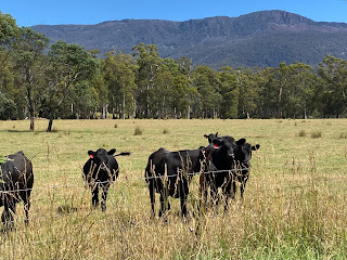
and turned onto the Caves walking track. The track initially crossed Palmers Rivulet and it was so nice there that I made coffee and had a long break. The track was a welcome change from road walking and climbed through ferny gum forest; it climbed relentlessly and was rocky but not difficult apart from a few washouts. I could see Mt Blackwood (the highest peak near here) clearly and had occasional views over the lowlands.

and turned onto the Caves walking track. The track initially crossed Palmers Rivulet and it was so nice there that I made coffee and had a long break. The track was a welcome change from road walking and climbed through ferny gum forest; it climbed relentlessly and was rocky but not difficult apart from a few washouts. I could see Mt Blackwood (the highest peak near here) clearly and had occasional views over the lowlands.
Half way up there were high cliffs, some with small caves and holes, then I came to a much larger cave with a long, almost level, rock platform under the overhang (making it a 2-storey cave). It had been suggested to me to sleep here and I decided that would be fun so I laid out my mat and sleeping bag and had a great al fresco sleep. 31 kms

15 January I continued up the track and saw a few rock pools (I could hear water in the night) then crossed the rivulet. I was walking at the edge of a cloud so the forest ahead was misty.

I emerged by the road on the Central Plateau at 1121 metres as the cloud cleared over the top of Mt Blackwood. Next was 18 kms of sealed road, and logging trucks. As I stepped off the road for one of them I saw a huge black snake. The roadside scrub was in flower and I had glimpses of the Great Lake.
For a half way break from the road I dumped my pack and went down to Cramps Bay on the lake; the shore was scrub and rocks and the water was bright blue. More road, which was fine during the long gaps in traffic: long climb to high point of 1190 metres, dry sclerophyll forest, views of Arthurs Lake on the descent, Three Sisters peaks in typical Tassie scrub, creeks, rock flows.
I finally turned off for Arthurs Lake onto a gravel road and then a rough path of gravel chips, with several creek crossings on stepping stones. The last kms were by the lake, and the pumphouse campsite (with wallabies) overlooked the water. 27 kms
16 January Beautiful starry night then big gusty wind in the morning. I climbed up to the flume for carrying water from Arthurs Lake down to the Great Lake and followed a trail alongside which was very pleasant, through dry bushland on a ridge on the plateau. I saw wallabies. The wind was strong and cold. I came to the southern tip of the Great Lake (not so blue today), having to make a big detour thanks to an agressive landowner, and headed away from it flanked by low scrub. This part was bleak in the cold wind. I met a cyclist for a chat. I had several kms on the A5 which had a good shoulder.
It was nice passing Shannon Lagoon with swans, then I came back to the Great Lake and could see it all the way to (and through) Miena, a very strung out place with several separate clusters of houses. It was trying to rain but didn't quite.
I stopped for coffee at the first Miena pub and stayed a long time. I was able to walk on a track by the water for a while and arrived at the general store to buy food, next door to the second pub, where I could camp. 23 kms
17 January It started raining at dawn, just lightly at first. I had coffee at the general store as locals came in and chatted about thunderstorms nearby. The shop lady was concerned for me and gave me a reflective strap to put on my pack. To me the hardest part was making the move to set off in the steady rain knowing I had only one place to shelter in 28 kms.
Initially I climbed to very exposed moorland with a strong tailwind, on the Marlborough Highway which turned out to be a narrow gravel road, already full of puddles. I descended to cross the Ouse River in a little gorge and once I reached the top again there was an icy cold squall which was nasty. This eased off and I came to Little Pine Lagoon; I went into the toilet and rearranged my gear.
When I emerged the weather looked a bit brighter and the rain was quite bearable. The road entered light forest and later there were grassy clearings where I saw wallabies. There wasn't much traffic and I only got splashed once. The rain stopped for about 10 minutes then became steady again. Near the end I followed high above wiggly Serpentine Creek and I could see Bronte Park in the distance but it took ages to get there; as I arrived (after six hours of nonstop walking) the rain stopped.
I went in the shop for a pie and coffee and permission to camp. I've never rated Bronte Park and it hadn't changed but I was very happy to be there. It was a hard day and I was pleased with myself. 28 kms
18 January I left Bronte Park in pale sunshine for a few kms of sealed road and highway. At Bronte Lagoon I turned off into the forest and a dirt road for the rest of the day. The road was hilly through forest of stringybark and ferns.
The rain returned, with a few heavier showers. I passed another lake and climbed for a glimpse of Dee Lagoon. Then I came to a line of shacks by the roadside and I stopped at the last one (as there was smoke coming from the chimney) to ask if I could sit under cover to rest; the woman invited me in for coffee. As we chatted there was a huge downpour.
I left: the sun came out, it rained, the sun came out, it poured. The road went beside the lake, pretty in a misty way 
then crossed the dam wall and climbed back into the forest where the ferns were lusher. The forest gave way to a vast grassy valley dotted with gums, then I had another patch of forest and reached another valley. It was really windy, like a storm was coming. There were no vehicles for ages then a police car passed and asked if I had seen a particular white ute; I couldn't help them.

then crossed the dam wall and climbed back into the forest where the ferns were lusher. The forest gave way to a vast grassy valley dotted with gums, then I had another patch of forest and reached another valley. It was really windy, like a storm was coming. There were no vehicles for ages then a police car passed and asked if I had seen a particular white ute; I couldn't help them.
At the edge of the valley I had a brief climb in forest to the Victoria Valley campsite for Tasmanian Trail users, on a hilltop among the trees, with a new 3-sided shelter. With anticipated overnight storms, strong winds and the cold, I put up my tent inside the shelter. 33 kms
19 January Very windy night. I soon left the road for a narrow track in the forest. I detoured to Victoria Falls, a reasonable cascade over a small granite cliff. I forded the river and the track was quiet through the forest, a bit wet in places. I heard lots of noises beside the track and finally realised the cause: echidnas. 
Where the forest had been cleared I could see a range of dry hills.

Where the forest had been cleared I could see a range of dry hills.
After a coffee break I went down a long way to cross a river and I was out of the forest into grazing land and more of a road. I could see a mountain range ahead. The sun was out but it was still windy. The road undulated past dry hills where there were masses of sheep; one time I saw a flock wandering without supervision up the road ahead of me. I turned back onto the road I had followed all day yesterday and then a last turn onto the highway and into Ouse, in the upper Derwent Valley.
I reckon this is about half way so I had a pie to celebrate and checked into the pub. I ate dinner there and it seems the chef quit after doing my schnitzel (with patrons waiting for meals!) 25 kms
20 January After a few kms on the highway (briefly leaving the Tasmanian Trail) I turned off for Meadowbank Lake on the Derwent River. It was peaceful there, completely still with lots of birds on the lake, and I had a coffee break.
Back on the official trail the road went up and over a huge hill, up in bush and down in the open, then I turned onto a very minor gravel road and came to a bridge over the Jones River where I got water (with difficulty). Such a lot of kookaburras everywhere. It was really pretty in the valley with grassy river flats and I had intended to camp there but it was only lunchtime.
I started my climb up Mt Bethune - I hadn't been able to get permission to cross this private land but I went anyway. There wasn't a path at first then only an intermittent worn strip of dirt through tussock grass and acacias and sheep. It was a sneaky mountain with three false summits. I enjoyed the climb and the scenery from the top was clearly going to be spectacular; more and more mountains came into view as I climbed. I have never seen so much sheep poo. At the summit (508 metres) I could see the winding Derwent, the tv pylons on Mt Wellington in Hobart, Mt Field, Mt Anne far to the southwest and much more.
I startled some wallabies on the way down. The descent came straight down the mountainside to a dirt road. The day suddenly turned sunny. I had a few kilometres on this deserted road with close up views of the Mt Field range. Saw an echidna. Short time on a sealed road and I saw a wombat dart into the bushes. I ended my day in Meadowbank conservation park, and found a perfect grassy patch in the white gum forest to camp. 28 kms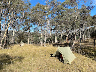

21 January There was a lot of wallaby/pademelon activity in the night and into the morning. After a few minutes walking I reached a tiny creek for my first flowing water since Jones River. The route came out onto open hillsides, dry tussock/marshland and evidence of sheep, and I followed a vague track until I stopped for breakfast with views of forested hills south. It was a grey day and Mt Wellington was in cloud.
I came to a trail down a dry gorge (a wombat ran along the edge and zipped into a hole) and then sheep grazing hillsides, and went onto an empty road, descending to the Derwent. After walking above the river and eating some blackberries I crossed the fast flowing Tyenna River, got water and took a break.
I braved the busy B61 for the last hour, noticing that hop fields are the thing here, and went straight to the Bushy Park roadhouse for pie, slice and coffee. I went on to the showgrounds to camp; not very inspiring but I'd had enough walking. The wind came up crazy again and I was glad to have a shed to sleep in, shared with a number of birds. 18 kms
22 January I had another hour on the B61 but this morning it was quiet. I turned off the bitumen for the long climb onto the Black Hills, mostly grazing and farms and there was no view until I was over the highest point on the road (520 metres). I climbed steadily and was amazed I had already done 13 kilometres when I reached the top. Up there it was chilly.

The view was a wonderful panorama of mountains: I reckoned I could see Mt Anne, Mt Picton, the Hartz Mountains and later a range between New Norfolk and Hobart, and Mt Wellington.
The long steep descent was on a sealed road so I was able to walk fast, coming down into the Derwent valley past small farms. I eventually crossed the Derwent, very wide here, and went up a final hill to the centre of New Norfolk. Straight to the bakery of course. Then I checked into the motel and washed my clothes. 24 kms
23 January Road walking to Lachlan and progress became slow once I noticed masses of ripe blackberries. There was no traffic after the settlement and I could see tree covered mountains ahead; soon I was climbing into them on a forest trail. It was great to be deep in the forest but sad to see so much litter among the trees. The trail went up and up, on the flanks of two mountains I had seen yesterday as I approached New Norfolk.
Soon the Jeffreys Track deteriorated into the mess I had read about: deep ruts, narrow muddy embankments and huge potholes filled with water. Hard going but I then turned onto White Timbers Track; this was worse because it was narrower and there was often no way to get around the giant puddles that were the width of the track and flanked by impenetrable bush. I grabbed onto branches and balanced precariously and was able to get through only wetting my right foot (many times). This was the most challenging part of my whole walk. It had started raining lightly.
Finally the trail improved to well draining gravel chips. I was on the edge of White Timbers Mountain and could see the higher part through the trees. I went over the highest point of the trail (826 metres) without fanfare and began to descend gradually (in Russell Ridge conservation area). The foliage was all bright green: big ferns, Tasmanian laurel, reedy grasses and the rain had cleared. At a junction I heard water and found a creek, and there was even a bench. Coffee.
I went on a bit further, crossing Judds Creek twice, and at the second crossing there was just the tiny patch of grass I needed; it was tricky fitting my tent in but so good to camp by water. I was directly beneath a conical forested peak. 32 kms
24 January I continued descending in the lovely forest and soon I was passing tucked away properties. Then I was out of the forest with views of the mountain ranges of the south west and entering the Huon Valley. Sunny. I got to Judbury and stopped at the park beside the Huon River. I had a stiff climb out of Judbury and just as the road levelled out I met two bike riders.
Further on I was on a ridge with fabulous views towards the southwest peaks. 
Another hefty climb and the whole horizon was taken up with mountains, even the distant Western Arthurs. Straight ahead I could see Hartz Mtn clearly. The trail returned to forest with a few less dramatic mountain views in the other direction and I undulated along.

Another hefty climb and the whole horizon was taken up with mountains, even the distant Western Arthurs. Straight ahead I could see Hartz Mtn clearly. The trail returned to forest with a few less dramatic mountain views in the other direction and I undulated along.
The descent was welcome, then I found water and started looking for somewhere I could camp. Nothing. I came out of the forest and immediately there were houses and no trespassing signs. Reluctantly I continued to Geeveston; luckily I had a tailwind and it was mostly downhill, into the Arve River valley. On the edge of town there was a cafe so I got hot chips and sat outside. I found the Tasmanian Trail camping area in a paddock by the Kermandie River. 36 kms
25 January I had breakfast in town (coffee and a stale donut) then walked along the Kermandie River before starting another long climb. There were both black clouds and blue sky and it was windy; fortunately I had a tailwind blowing the clouds away from me. I got onto a ridge and had a brief sighting of the huge Huon River estuary.
I said a final goodbye to the Tasmanian Trail for an alternative route and turned onto a wide and completely deserted logging road. I saw an echidna in the middle of the road and first it froze then it strolled off and hid behind some blades of grass. I found water but it was too windy to be able to boil it.
Instead of going directly to Dover I detoured to Esperance River campsite which sounded like it was worth the extra kilometres. I took a much smaller trail undulating through the regenerating forest (had a peek of Mt Adamson) still really windy but the threat of rain was gone. A big black snake slithered off the track.
I came to a bridge over the Esperance River, a very pretty spot with rapids and rock platforms
and found a place to put up my tent above the river, among small trees for shelter. 21 kms

and found a place to put up my tent above the river, among small trees for shelter. 21 kms
26 January It rained early on but I got up to blue sky. I had breakfast by the river and saw a rainbow over the bridge, soon it was raining again. I walked the forest road and later saw a double rainbow. The showers came and went. I reached the highway at the Esperance River estuary, had a boring stretch then I was right on Esperance Harbour with views of the islands in the bay and hills beyond.

I walked into Dover and went in a cafe, glad it was open since Dover is such a tiny town. It was horribly windy and the weather forecast wasn't good for tomorrow so I decided to get the bus to the Kermandie pub near Geeveston for the night. 13 kms
27 January Rest day. I took the bus back to Dover, checked out the foreshore with views towards Bruny Island and camped at the caravan park. Extremely windy, several rainbows. Dinner at the RSL with Stan, a bike tourist.
28 January I walked around the foreshore and returned to the Esperance River on the main road, picked an apple and lots of blackberries, then turned onto an old logging road. I was close to Mt Adamson, unfortunately the top was in cloud. The wind made the weather just as changeable as before but I didn't expect rain.
Back on the busier road I needed a break and I stopped at Southport Rivulet: yucky water; then it was too windy; finally beside Lune River I could get water and sit in a clearing. Next I sat by the sad abandoned railway office at Ida Bay for lunch and decided to continue south despite uncertain camping options. The road was unsealed from there, plunging into forest, busy with bursts of vehicles and dusty and not very interesting at walking pace. Hilly. It was a slog. When I got to the d'Entrecasteaux River I tried to get water but the steep access wasn't safe, so instead I flagged down a car for water and after a drink I felt much better.
I finally reached Recherche Bay: coastline at last. It looked lovely in the evening light with gentle waves. There was still a bit further to go for the campsite at Gilhams Beach. It was a long day, worth it to camp with the sound of the waves. 35 kms
29 January Breakfast on the beach, sunny and lots of forest covered hills and little bays. The road went close to the water passing a few bays, then more forest and more coast. Far less traffic. The road became sand. The weather didn't look like remaining sunny as forecast. I came to the bridge over Cockle Creek and the end of the road. I had another coffee on this beach.

My last eight kilometres to the coast was on the South Coast Track. First through rocky gum forest, then a long stretch on boardwalk across boggy ground surrounded by low hills (coral ferns, scrubby tea tree), then tall tea tree forest followed by a damper forest with creeks.
Suddenly I could hear what had to be the roar of the ocean - it was too loud to be the wind. I descended to a lookout over South Cape beach and it was a wild sight with the rough water, Lion Rock and headlands beyond, South Cape and high cliffs back in the other direction. I had to cross the granite cliffs of Coal Bluff, not going near the edge, and descended to the beach.

The South Coast! My goal achieved. I walked the length of the beach (at the water's edge sat the biggest collection of seagulls I've ever seen) and climbed up to the viewless campsite in the trees. I had lunch and it started raining. I found it too damp and dismal at the campsite so I relocated to a spot just behind the beach with its own little table and close to the creek; the only disadvantage was that I had to put up my tent on sand. When the sun returned I sat on the dunes. The wind was crazy strong. 14 kms

30 January The weather was so good 

that I decided to continue to South Cape Rivulet. I saw a spotted quoll scurry into the bushes. I climbed a hill into the forest of melaleuca, laurel, cutting grass and blechnum with a little mud. At the top was a wonderful view of a series of headlands and beaches southwards. This has to be one of the best views in Australia: a series of five headlands with each one the cliffs becoming higher and steeper.


that I decided to continue to South Cape Rivulet. I saw a spotted quoll scurry into the bushes. I climbed a hill into the forest of melaleuca, laurel, cutting grass and blechnum with a little mud. At the top was a wonderful view of a series of headlands and beaches southwards. This has to be one of the best views in Australia: a series of five headlands with each one the cliffs becoming higher and steeper.

I descended to a beach of sand and large pebbles (it was high tide so I had to walk on the pebbles). Another low hill in forest and I emerged on the beautiful beach leading to the rivulet. I was keen to see the conditions: shallow. I sat on a log and made coffee, completely still and nobody around. 

On the way back I had lunch at the high lookout, inland the endless forest and craggy Mt Pindar and rounded Mt La Perouse.
I returned to South Cape beach, the wind had come up so I didn't stop. Back in the forest I stopped to make coffee at what's become my usual spot along the creek. Then the final traipse across the valley on boardwalk (lovely pink trigger plants and fairies aprons) and the rocky contouring of low hills.

I am pleased to have done this section of the South Coast Track in good weather, third time around.
I walked over to the camping area at Boltons Green and found a quiet corner but just as I put my bag down a big snake slithered across the grass. So I changed my mind and went further along. A wallaby came to visit as I lay in my tent. Clear starry night. 15 kms
Total 511 kms
