14 April My first extended bike trip since 1990! A little tour of Eastern Tasmania, with the route dictated by a need to find accommodation each night.
I set out from home to ride to Geelong in order to take the ferry to Devonport tomorrow. I went along the Bay Trail to the Westgate punt and on the way across the river the guy, as usual, pointed out all the things wrong with my bike that I need to get sorted at a bike shop, but since he’s deaf there’s no point replying. I cut through the back of Williamstown, went along the foreshore through Altona, did the Altona wetlands and followed Skeleton Creek. I thought I found a route that avoided the Princes Highway but I ended up having to ride 10 kilometres along it; at first this was fine because the traffic was stationary. I had a tailwind so it was soon over. I got onto a back road to Lara, stopped at the bakery and took a bike trail into Geelong along a creek. Just before the cement works there’s a nice bayside stretch, but after that the water views are blocked by ugly industry all along. I went right to the new Spirit of Tasmania terminal to see where it was and then turned back to my motel. 92 kms
16 April This turned out to be a long hard day for a cycle touring novice but luckily the forecast rain didn’t eventuate. (I had got soaked in riding less than a kilometre from the ferry to my motel last night and I was not looking forward to rain today.)
I was able to use the Tasmanian Trail as my route to Deloraine. I followed the Mersey River from Devonport to Latrobe and then took the long variation to (topiary) Railton. This turned out to be hilly but not as bad as what was to come later. It was pleasant farmland and no traffic. I had coffee in Railton and embarked on the MTB trail to Sheffield which was through forest and rougher going than I expected, but flat. I had lunch in (mural) Sheffield, very busy there including a man who had brought his llama into town.
After Sheffield I had a really hilly ride with lovely views of Mt Roland 
- a couple of the hills were just too steep for me - and then a nice dirt logging road with views towards the Western Tiers that was only undulating, until I crossed the Mersey River and it became very hilly again. I was getting quite sick of the hills although the distant mountain views were good. All day I saw lots of birds, green parrots, kookaburras, herons, ibis, plovers, ravens. As I got closer to Deloraine I had a clear view of Quamby Bluff. I was happy to reach Deloraine; not surprisingly it was completely dead late on a Sunday afternoon. 98 kms

- a couple of the hills were just too steep for me - and then a nice dirt logging road with views towards the Western Tiers that was only undulating, until I crossed the Mersey River and it became very hilly again. I was getting quite sick of the hills although the distant mountain views were good. All day I saw lots of birds, green parrots, kookaburras, herons, ibis, plovers, ravens. As I got closer to Deloraine I had a clear view of Quamby Bluff. I was happy to reach Deloraine; not surprisingly it was completely dead late on a Sunday afternoon. 98 kms
17 April There was a misty rain and not much view as I left Deloraine and it was cold. The rain stopped and I had clearer views of the Western Tiers as I rode quiet roads, passing lots of sheep paddocks, on a route of my own design. Less steeply hilly than yesterday and very little traffic. After over 50 kms I stopped in Longford (convict built church, toilets, bakery) and sat in the sunshine. Then I did a brief detour by the river and headed for Launceston. Lots of long hills and straight into the wind. There was a long descent into the city centre, and then my motel was at the top of a very steep hill. 88 kms
18 April The weather did not look promising. I left Launceston on a bike path by the river, across parklands, and went along a rail trail on a levee in bush. A part of the city I was unaware of. Then I rode on a busy road north towards Lilydale with a whopping hill. I was able to turn off onto a quieter road through bush and passing farms but the rain was a problem: I had to keep stopping to shelter under whatever I could find. There were many vineyards. In Lilydale I stopped for coffee and when I set off again the weather was brighter. I checked out Lilydale Falls. There were 3 huge hills to get over and then I turned onto a dirt road which was the day’s highlight although it started raining again. The countryside varied between typical Tasmanian moorland, forest and green cow pastures. Unfortunately I ended up on another busy road into Bridport. I was keen to get a first view of the ocean but I only saw it, and the endless white sands, from the top of the final hill before Bridport. Everything was already closed in town except the IGA. When the weather cleared I went for a walk along the foreshore trail passing lots of little beaches. 79 kms

19 April I had breakfast at the bakery while it poured and I left when I was sure the rain had finished. I rode along the foreshore and then had to take a fairly busy road to Scottsdale. I was riding straight towards Mt William. The road was flattish then hilly.
After my break in Scottsdale I had a long ride on the North East Rail Trail which was extremely nice. It began in farmland but went into sclerophyll forest, through some granite cuttings, and the trail was flanked by king ferns. 
I felt very cold. There were views through the forest right to the north coast and of lots of forest covered hills with a green valley far below. The climbing was gradual and while I was aware the trail was all uphill I didn’t think I had climbed so much. The trail ended at the highway and I immediately turned onto a detour suggested by my gps which proved also to be great riding. I descended on a dirt road to a valley and the settlement of Legerwood with a line of unusual timber statues, and then ambled past fields on a narrow sealed road, very winding. It was lovely. I rejoined the highway to descend to Branxholm; it surprised me with a shop (and several closed cafes) so I had a snack. I found a little riverside/pondside trail to take me into Derby (a former mining town now full of mountain bikers and no shop, so I was glad I had snacked in Branxholm). 71 kms

I felt very cold. There were views through the forest right to the north coast and of lots of forest covered hills with a green valley far below. The climbing was gradual and while I was aware the trail was all uphill I didn’t think I had climbed so much. The trail ended at the highway and I immediately turned onto a detour suggested by my gps which proved also to be great riding. I descended on a dirt road to a valley and the settlement of Legerwood with a line of unusual timber statues, and then ambled past fields on a narrow sealed road, very winding. It was lovely. I rejoined the highway to descend to Branxholm; it surprised me with a shop (and several closed cafes) so I had a snack. I found a little riverside/pondside trail to take me into Derby (a former mining town now full of mountain bikers and no shop, so I was glad I had snacked in Branxholm). 71 kms
20 April Derby wasn’t my scene at all but I felt I should try a mountain bike trail so I opted for the Ringarooma River Trail. It was a puddly track beside the river, mostly in bush and lots of short ups and downs. There were narrow logs across the path and rough rocky bits and sandy stretches. The river was pretty and I liked the grassy flats. 
I came to the highway (with relief) and continued to Weldborough up long but rideable Weld Hill, and called in at the pub for coffee. The road continued uphill in nice bush to the Blue Tier with extensive views east and I came into sunshine. There was minimal traffic despite this being the A3. The descent was really long, down to a farmed valley. I detoured to a cheese factory/cafe in Pyengana which was closed. The road was pleasantly undulating to St Helens, some coastal forest then a glimpse of the blue bay. I am enjoying the feeling of getting around under my own steam. 70 kms

I came to the highway (with relief) and continued to Weldborough up long but rideable Weld Hill, and called in at the pub for coffee. The road continued uphill in nice bush to the Blue Tier with extensive views east and I came into sunshine. There was minimal traffic despite this being the A3. The descent was really long, down to a farmed valley. I detoured to a cheese factory/cafe in Pyengana which was closed. The road was pleasantly undulating to St Helens, some coastal forest then a glimpse of the blue bay. I am enjoying the feeling of getting around under my own steam. 70 kms
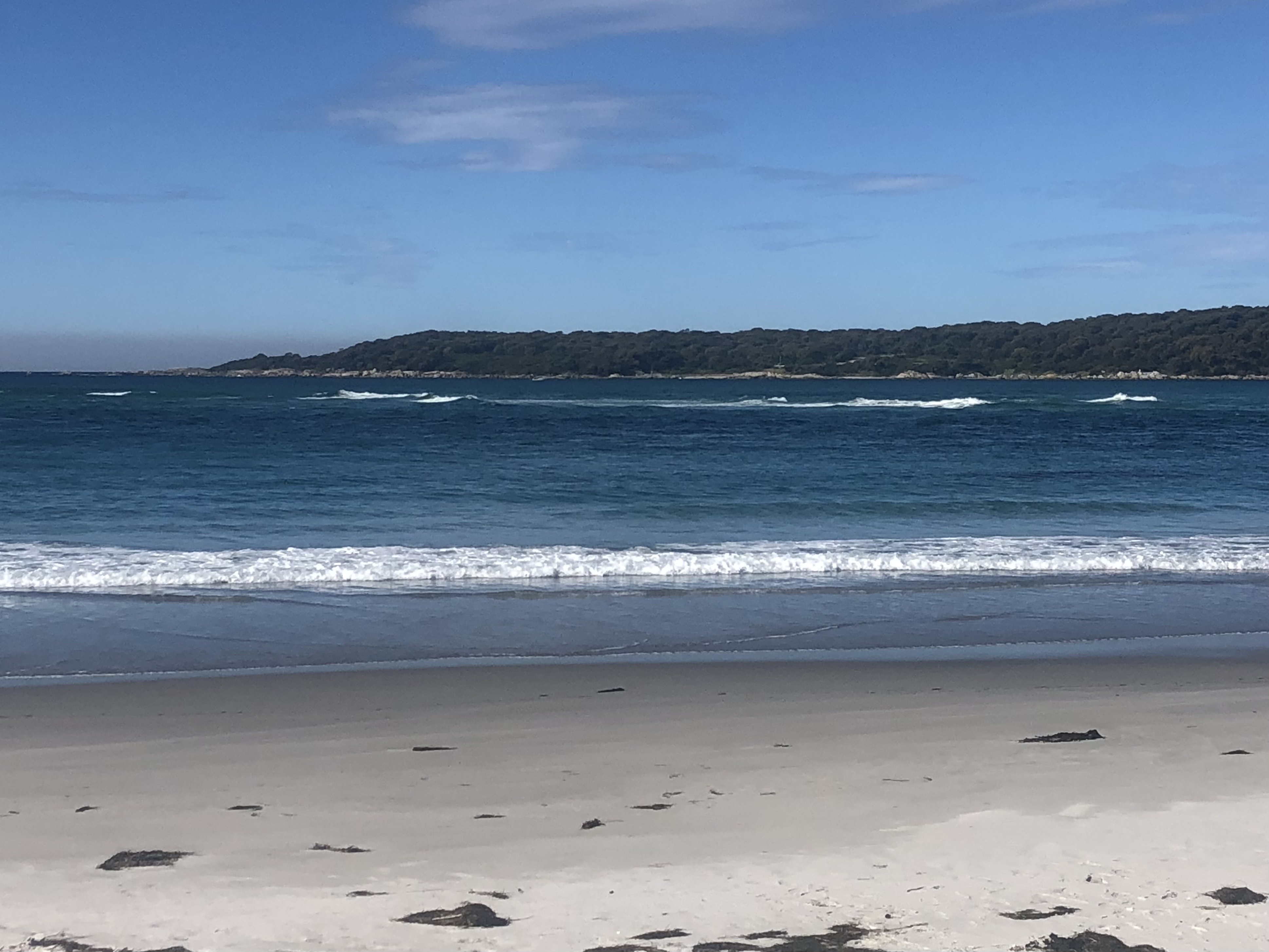
21 April I did a couple of short rides from St Helens. First I rode out to St Helens Point. There was a nice bike path along the bay and then a hilly road through coastal scrub out to the point; I did some detours on gravel roads but the corrugations were bad. I parked at the end of the road and did a walk around the point to Beerbarrel Beach. There were lots of the area’s signature orange-tinged boulders around the point.
The beach was lovely white sand with a view of the hilly coastline south.
I returned to town for morning tea.

The beach was lovely white sand with a view of the hilly coastline south.

I returned to town for morning tea.
Next I went the other direction along the bay out to Humbug Point Recreation Area. There was a difficult hill; I struggled up on the bitumen only for the climb to steepen when I turned onto gravel. At the top the going was easier but the corrugations were terrible. This was nice banksia bush, rosellas, no view until I descended to Dora Point, where there was a white sand beach and a view directly across to where I was on my other ride. 
I returned through Binalong Bay, where I ended my Bay of Fires walk last year, with lovely views of long sandy beaches and easier riding. I came back along the bay. 58 kms
I returned through Binalong Bay, where I ended my Bay of Fires walk last year, with lovely views of long sandy beaches and easier riding. I came back along the bay. 58 kms
22 April Sunny day. I left St Helens with a big hill and went along the highway, passing white Beaumaris beach, to Scamander. I really wanted coffee but initially it appeared to have no cafe, then I found a lovely place looking out over the lagoon at the far end of the town. Not much further on I left the road to check out Winifred Curtis Reserve and had some nice single tracks, sandy and a bit flooded, ending up at a lookout over another lagoon. I left the main road again to drop into Falmouth, a tiny settlement on a lovely bay. The next few kilometres were right by the water, lots of orange stained boulders.
After that I had a long stretch on the hilly highway which was quite busy. I stopped at the next beach I saw, Little Beach, with perfect white sand, and then had a nice view of Lagoons Beach, also white sand. Mostly the road was far from the coast although I could always see the ocean. I returned to the coast at Denison Beach, long and white,
sat there a while and continued to Bicheno. 85 kms

sat there a while and continued to Bicheno. 85 kms
23 April Another beautiful day. I went for a walk around the foreshore on boulders and path, stopping at the blowhole, then had breakfast while the bakery was open. I rode out to Douglas Apsley NP and did the walk from the waterhole to the gorge on the Apsley River. It was casuarina and grass tree bush with a long climb from the waterhole (where I got wet feet as the stepping stones across the river were under water) and a steep drop back down to the gorge. Lots of birdsong, peaceful. The water level looked too high for returning in the river bed. 
Back in Bicheno I sat on the beach. 23 kms

Back in Bicheno I sat on the beach. 23 kms
24 April After breakfast at the bakery I left Bicheno on the highway and I was on the highway most of the morning. I stopped for another coffee quite soon at the Pondering Frog cafe where the owner poured cold water on my plans. The landscape - grassland, vineyards, distant mountains - was nice and the riding in the sunshine was pleasant when there was no traffic. I had a great view over a large area from the top of Cherry Hill. A bit before Swansea I turned off the highway to go towards Nine Mile Beach and soon I found an access trail to the beach. It was long and lovely with a view across to the Freycinet peninsula and its rocky peaks.
I had a paddle, the water was cold. A woman walking said I could ride along the beach so I did just that, for 7 kms. It was absolutely lovely riding by the water, crunching shells and surprising the oystercatchers. I was also happy because I like to do something each day that justifies riding a mountain bike. To get off the beach I had to use someone’s driveway. I went a km up the road to Mel’s Oyster Shack on a lagoon and ate 6 oysters sitting overlooking the oyster beds. Nice. Then I returned on the beach (I found a fire trail for access) following my earlier tracks so I knew where to leave the sand, and took the highway into Swansea; the town centre is oddly situated on a right angle bend in the main road. I checked out the headland overlooking several beaches. 68 kms

I had a paddle, the water was cold. A woman walking said I could ride along the beach so I did just that, for 7 kms. It was absolutely lovely riding by the water, crunching shells and surprising the oystercatchers. I was also happy because I like to do something each day that justifies riding a mountain bike. To get off the beach I had to use someone’s driveway. I went a km up the road to Mel’s Oyster Shack on a lagoon and ate 6 oysters sitting overlooking the oyster beds. Nice. Then I returned on the beach (I found a fire trail for access) following my earlier tracks so I knew where to leave the sand, and took the highway into Swansea; the town centre is oddly situated on a right angle bend in the main road. I checked out the headland overlooking several beaches. 68 kms
25 April All highway today and there was much more traffic. I made several off road forays in the early part: Cressy Beach, Spiky Beach, Spiky Bridge (because of slate pieces all along the top), I rode a chunk of Kilverton Beach, Mayfield Beach and a longer detour to the saltworks ruins in Swanport and a lovely but tiny beach. This part of the road had continuous good sea views, rocky coastline and views of Freycinet and Schouten Island and passed more vineyards. Then I saw a sign advertising coffee in one km and I was surprised to find the cafe open; I paid $7 for a coffee with all the surcharges but it was huge and worth it. Also to my surprise another bike rider showed up and we had a long chat. After that the road was inland and less interesting so I rode to Triabunna without stopping (the outline of Maria Island straight ahead) and rested at the wharf. I went on to Orford via some steep waterside hills. There was a path behind a long beach as I came into the town and I generally thought the place was nicer than I remembered. I did some beach riding and found a pine flanked trail that went along the foreshore and up onto the cliffs, ending at Spring Beach. 
74 kms

74 kms
26 April I left Orford in a biting cold wind for a stretch of highway that is reputedly unpleasant. The road was close to the wide Prosser River, just above it on my right and with granite cliffs by the road on my side. I was lucky with low traffic at the squeeze points and it was very beautiful, almost a gorge. Later this road widened and the traffic was bad but the scenery was good: some low cloud over the grassland and forested hills. The road had the biggest hills for many days. I stopped at the Buckland roadhouse for second breakfast and finally left the A3 (which I joined after Derby). Cute church.
I turned onto a quiet road, sealed and unsealed, which I loved. This was perfect for riding with virtually no vehicles and great scenery: grazing land, light forest, hills. I had a whopping hill to start and I had to remove my warm clothes at a break from the climbing. There were constant hills and descents to creek crossings. 
I went through the hamlets of Nugent and Forcett
then decided to go to Dodges Ferry on the coast because I liked the name. The road was busy. After much searching I managed to access a couple of beaches. From the smaller one I could see Mt Wellington, a couple of islands, several headlands, cliffs on Bruny Island.

I went through the hamlets of Nugent and Forcett

then decided to go to Dodges Ferry on the coast because I liked the name. The road was busy. After much searching I managed to access a couple of beaches. From the smaller one I could see Mt Wellington, a couple of islands, several headlands, cliffs on Bruny Island.
Then I found a longer beach (Carlton Beach) and rode the full length, several kms; it was wonderful with the gentle waves. I left Dodges Ferry on a quieter road with a huge climb through Lewisham. The water views of the top were fabulous on such a sunny day. Soon I joined the A9 for the final 5 kms into Sorell, long climbs and the busiest road I’ve been on, it was horrible even with a wide shoulder. I was pretty tired by the time I reached Sorell after a day of hills. 84 kms
27 April I crossed huge Pittwater on a long bridge and turned off for Seven Mile Beach through forest. I was able to ride the whole beach. Then roads through Hobart fringe on a plateau above the water, still rural. I went out to Tranmere Point and took the foreshore bike trail into Hobart, riding Howrah Beach and Bellerive Beach on the way. This was a nice trail with some short steep hills, beside rock platforms, some bush and with extensive views out of the bays. I crossed the Derwent River on a tiny raised pathway on the massive bridge, which I found truly scary because it was so narrow, and went to Salamanca Place to recover. My finish line was Sandy Bay (just as it started raining). 55 kms
29 April I had to ride 45 kms from Geelong to Werribee to get the train home.
Total in Tassie: 853 kms; 9500 m elevation gain
