It was high time for a return to the Heysen Trail but the trail closures for the fire danger season were delaying me. In mid April I could start a northern section and I decided to tag on the half section in the south from Mt Compass to Bridgewater where camping was allowed and only small portions of the track might be closed (sshh).
April 8 It was good to be back after almost a year away (save a day walk in December), however this seemed a long hard day. It was hot, there was plenty of tedious road walking and the leg with the bad knee kept cramping. I started where I left the trail in early May 2021 with a long bitumen road walk out of Mt Compass to get back onto the trail and then moved onto a mixture of gravel roads, single track through a couple of wooded conservation parks with ferns and grass trees (Finiss and Mt Magnificent), forestry roads in the Kuitpo state forest (pine plantations on one side and native bush on the other) with a short section among the pine trees. I saw quite a few kangaroos. Everything was very dry apart from a lovely creek where I had a long break. It wasn’t clear if all of the trail was open but I was happy to see Chookarloo campsite had other campers and there was water in the tank. 29 kms
April 9 I went into woodland and then dirt roads and I suddenly noticed the trail markers were leading me on a different and longer route than was showing on my Heysen gps track. After a spell back in the pine forest I found I was still not on the gps track and I was going to do an extra 5 kms before reaching my first scheduled rest, despite following the trail markers the entire time. I was not happy and I was already tired when I got to Rocky Creek campground after 17 kms rather than 12. I had coffee sitting in the shade of the water tank. It was another hot day.
When I left I resolved to follow the gps track and with 400 metres of trespassing on SA Water property where the official route makes a big detour - a mob of kangaroos saw me and I’m sure they wouldn’t snitch - I clawed back a couple of the extra kms. There was a maze of forestry tracks so I had plenty of options. I went through a bit of conservation park (typical Heysen thing of being squeezed between a fence and the bush while there was a good track on the other side of the fence and lots of trails through the bush), passing a past gold mining area. Farmland followed with some curious stretches of boardwalk and in a few places I had to wait for the cows to move off the trail, and then some climbing along fence lines. I could see the Mt Lofty spire in the far distance so I knew I was heading in the right direction. The last part was on bitumen roads leading into Mylor.
I intended to camp at Mylor oval, which in my notes was the recommended Heysen campsite; when I got there I found they had a special event on and the whole town was there, plus No Camping signs. I had nowhere else to go (that Heysen issue again). Fortunately I found an area adjacent to the oval (with a shelter for cooking) so I cooked, then sat and waited for it to get dark to put up my tent. 31.5 kms
April 10 Only a short way to go today, luckily, because when the sun came out it was immediately blasting heat. I had a brief foray into Mylor conservation park, an unnecessary trail extension but lovely stringybarks, then the remainder through a bushy reserve above the road which was surprisingly nice.
At the finish line I headed straight to the Little Cog cafe by the old mill, which must be the only cafe in Bridgewater as it was hopping. 7.5 kms
The next day I went north by bus to resume the trail in Crystal Brook and head to Quorn where I began my first outing on the Heysen in July 2019.
April 11 Just a stroll to get out of town today and make the distances work on the other days. I followed the creek, dry and nothing crystalline about it, 
first at the edge and then on a dirt road to Bowman Park hut (bunk beds, furniture, inside tap) surrounded by dry bush by the creek bank, rabbits, crows and kangaroos, open only to Heysen walkers. Sometimes there’s nowhere to sleep, sometimes there’s luxury. According to the logbook nobody had been there since November. Up the road was Bowman Park with the grass being sprinkled and a bunch of RVs. I took a mattress onto the veranda and slept there, wearing my head net because of the mozzies. 4.7 kms

first at the edge and then on a dirt road to Bowman Park hut (bunk beds, furniture, inside tap) surrounded by dry bush by the creek bank, rabbits, crows and kangaroos, open only to Heysen walkers. Sometimes there’s nowhere to sleep, sometimes there’s luxury. According to the logbook nobody had been there since November. Up the road was Bowman Park with the grass being sprinkled and a bunch of RVs. I took a mattress onto the veranda and slept there, wearing my head net because of the mozzies. 4.7 kms
April 12 It would have been nice to follow the Crystal Brook next but they’ve rerouted the Heysen along roads, luckily quiet and with some views over the farmland. This also meant additional kms. After the detour I climbed to a ridge and undulated there for the rest of the day. All on roads which were peaceful, and expansive views with patches of green but mainly yellow/brown hills and few buildings. It became very hot and then very windy. I called in at a property where they have a water tank that walkers can use since the Beetaloo tank was destroyed; I didn’t see the owners but I found the water. I had a few stops when I saw shade and ate lunch at the former Beetaloo shelter site under big trees. Then I had a short climb to the Wirrabara forest (native bush) and the replacement shelter, where I was pleased to find water in the tank. I decided to sleep on the bench in the shelter. 25 kms
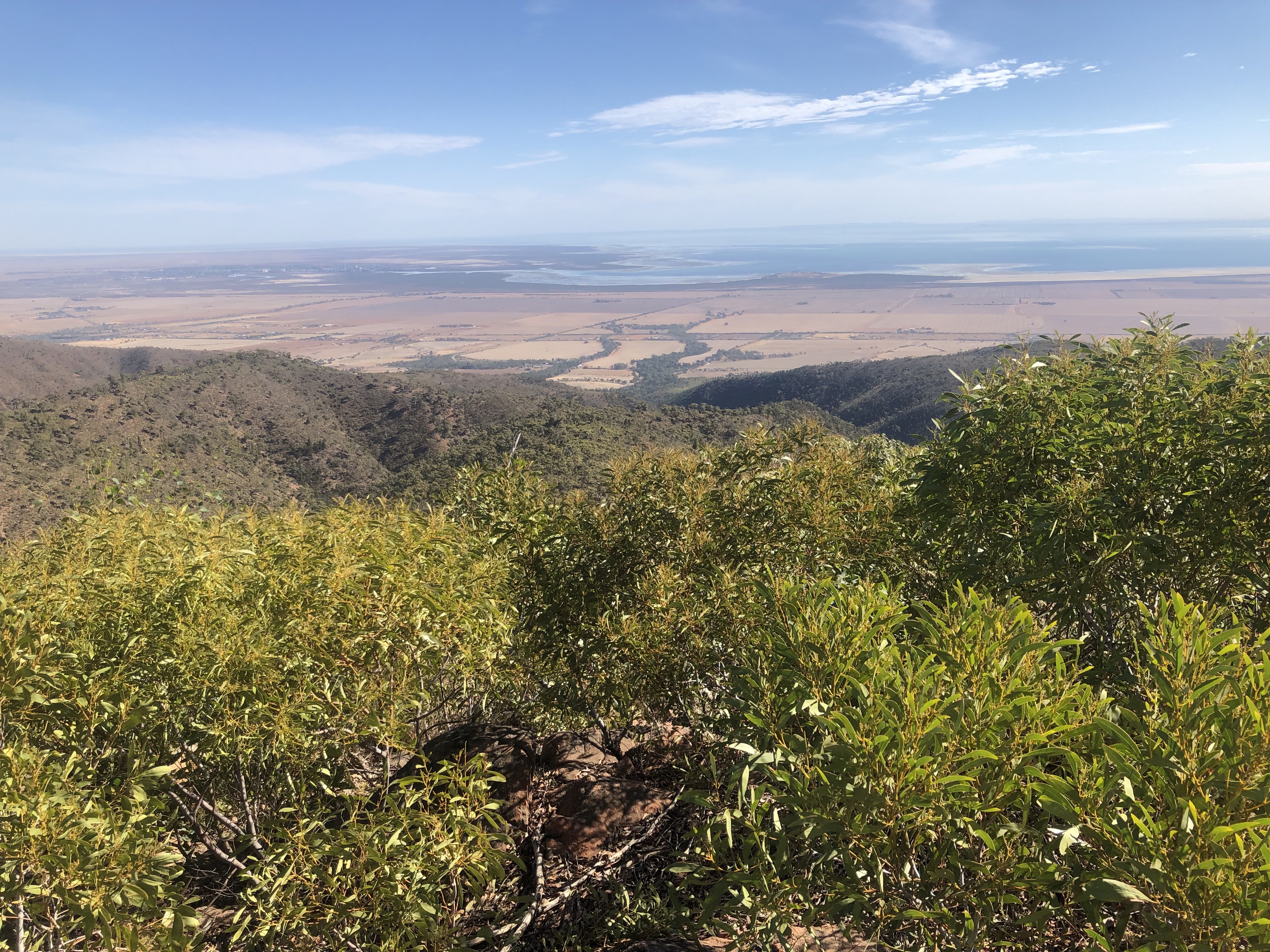
And 13 Windy night and windy morning. The trail took an immediate turn for the better. I embarked on a serious roller coaster of a walk along the edge of the southern part of the Mt Remarkable National Park as I climbed towards a couple of TV towers on a hill called the Bluff. I was deep in mallee forest with views over Port Pirie and the Spencer Gulf. It was hard hilly work and there was no view from the TV towers. I went on, with a sharp and loose descent that was like walking down a rock slide, interspersed with some steep uphills. I came to a clearing and was surprised not to see any trail markers; to my horror I realised I had come the wrong way from the towers. Retracing my steps the 2 kms back up the trail was awful and I couldn’t do it in one go as it was so hot. (In my defence I had been confused by seeing a Heysen sign at the start of the track; I don’t have time to read wordy Heysen instructions and it actually said not to go that way!)
The real route was much more pleasant, undulating on a sealed road to a brand new lookout platform (over the Gulf) 
and then returning to a rough track (Go Cart Track) in mallee in Wirrabara Forest. As I passed over Frypan Hill (views east towards a mountain range) I heard a commotion in the bushes and a couple of wild goats appeared looking distraught; then I saw several more, all having trouble escaping from me because the bush was too dense. When I got to Go Cart Track shelter it was just that: a roof. Also, thankfully, a tank with water.
and then returning to a rough track (Go Cart Track) in mallee in Wirrabara Forest. As I passed over Frypan Hill (views east towards a mountain range) I heard a commotion in the bushes and a couple of wild goats appeared looking distraught; then I saw several more, all having trouble escaping from me because the bush was too dense. When I got to Go Cart Track shelter it was just that: a roof. Also, thankfully, a tank with water.
Soon after I got there a ranger arrived and commented that the camping season hadn’t started yet (2 days away), but he said Don’t worry, you’re close enough. Then he told me not to be alarmed if I heard rifle shots, as they were hunting feral goats.
The shelter was in a nice spot with views over the top of Telowie Gorge to the Gulf far below and I saw town lights after dark. I planned to sleep al fresco under the roof as there was no chance of getting tent pegs into the hard ground. 23 kms

April 14 Again a really windy night. I continued on a narrow ridge in the forest, (no more goats, only kangaroos)
then a long downhill on single track into a deep gorge; the creek at the bottom was tiny, and then I had a long climb back up on a rough track. Soon I left the forest and was walking over grassy hills with sparse woodland. It was very peaceful although getting hot. Some of it was just cross country without a trail.

then a long downhill on single track into a deep gorge; the creek at the bottom was tiny, and then I had a long climb back up on a rough track. Soon I left the forest and was walking over grassy hills with sparse woodland. It was very peaceful although getting hot. Some of it was just cross country without a trail.
Then back to farm roads. It was really muggy. For a short while the route went along fences and I stopped at a broken cattle trough for a coffee break. The last three kms into Murraytown I walked along the highway as the town is off the trail. I could see a prominent landform in the distance which I guessed to be Mt Remarkable. Everything in Murraytown has closed down but they turned the town park into an official campsite, a lifesaver for Heysen folk. The caretaker said I was early for a hiker, coming even before the fire danger season was over. 26 kms
April 15 I walked out of Murraytown along the highway then moved onto farm roads with grazing sheep and wheat fields, Mt Remarkable always there in the distance (but getting closer). 
Again it was hot, still and peaceful. It takes a few days to get to enjoy the Heysen road bashing. The land was gently rolling with patches of gum trees. I saw green parrots, wagtails, galahs, honeyeaters and heard a lot of kookaburras. I did a typical Heysen roller coaster along a fence line crossing several gullies, trying to sneak past the sheep sheltering under trees, and walked the last part into Melrose on a dirt road.


Again it was hot, still and peaceful. It takes a few days to get to enjoy the Heysen road bashing. The land was gently rolling with patches of gum trees. I saw green parrots, wagtails, galahs, honeyeaters and heard a lot of kookaburras. I did a typical Heysen roller coaster along a fence line crossing several gullies, trying to sneak past the sheep sheltering under trees, and walked the last part into Melrose on a dirt road.


I needed to resupply in Melrose and I had been very worried that everywhere would be closed on Good Friday. It looked dead as I arrived but the place is an MTB mecca and the bike shop slash cafe was doing great business, and the servo slash food store was open. The enormous caravan park was so incredibly crowded that I was now very relieved they had said they had no room when I enquired.
I lingered several hours in town, bought food and set out for the summit of Mt Remarkable. It was 31 degrees. For some reason I thought the climb was going to be quite short; it wasn’t that short (6.5 kms) but it was very zigzaggy and gentle. It was all in forest, crossing numerous huge rock flows and gullies, with views eastwards where I had come from.
The summit (960 metres) was a nice cleared area with benches among the gums, grass trees and a white flowering bush I see everywhere. It was hard to get a view through the bush. There were kangaroos snacking. So I enjoyed a snack too and decided to stay the night. I saw an amazing red sunset through the trees to the west and then the almost full moon just above the treetops to the east. 25 kms
April 16 Yay! The Heysen is officially open today, up north. I woke to see a rim of bright orange on the horizon and a bit later I saw a beautiful sunrise. The start of the descent (steeper than my climb) was in the forest and then I came out onto rolling grassy hills with scattered gums. I stopped at Grays Hut, in a large clearing, where a hiker was packing up - we had a long chat - then I sat in the hut enjoying the breeze through the doorway.
The trail continued over dry hills with densely forested ranges in the distance. I soon found myself off the route and went cross country to get back. The Heysen seemed unnecessarily complicated here and I was constantly losing the official route when the trail I was on was perfectly fine. There were whopper hills and it was hot.
Firmly on the correct path I was getting a bit bored with the relentless hills (but liking seeing so many kangaroos) when the route had some surprises in store. First I followed a grassy creek. Then I climbed up a significant hill deep in dry forest where the trail was barely discernible; at the top (around 600 m) was a huge cairn and great views over forested mountains and the plains around Wilmington. And Mt Remarkable. 
The descent was very rugged, rocky and hard to follow.

The descent was very rugged, rocky and hard to follow.
At the bottom was Stony Creek shelter, by Stony Creek, which was the stoniest creek I’ve ever seen, in a gorge filled with the distinctive yellow trunked SA blue gums. 
(Shame about the large number of bees but they went to bed early.) It was a wonderful place and I made up my bed on the platform. This was my first windless evening/night and it is so great to be able to sleep outside like this. 18.5 kms

(Shame about the large number of bees but they went to bed early.) It was a wonderful place and I made up my bed on the platform. This was my first windless evening/night and it is so great to be able to sleep outside like this. 18.5 kms

April 17 I did the short walk into Wilmington, wondering if it would be crazy busy like Melrose. It was not; it was a quiet place on the road with just a little bit going on. I headed straight to the cafe as everything was closing early on Easter Sunday. Then I arranged a room at the pub, bought food, had a chat with the hiker from yesterday who turned up and had a chat with a couple who help maintain the Heysen along here. 7 kms
April 18 Quite a challenging day and not really what I expected. I left Wilmington and followed the roadside reserve to Horrocks Pass then turned to climb high above the pass. The surrounds were dry hills some of which were covered with only juvenile grass trees. 
I was surprised to be looking down on Wilmington as I thought I was some way away by now, and the other way I could see the top of Spencer Gulf, a wind farm near Port Augusta and lakes beyond. It was a cool day and windy. I stopped at a new hiker shelter (installed last week) on a hilltop where a gale was blowing and it had not rained recently so there was no water in the tank. It was so odd to be cold after all the hot days. As I sat there two hikers came by.

I was surprised to be looking down on Wilmington as I thought I was some way away by now, and the other way I could see the top of Spencer Gulf, a wind farm near Port Augusta and lakes beyond. It was a cool day and windy. I stopped at a new hiker shelter (installed last week) on a hilltop where a gale was blowing and it had not rained recently so there was no water in the tank. It was so odd to be cold after all the hot days. As I sat there two hikers came by.
The next part was real hardcore Heysen: along fences, random bits of track, suddenly veering cross country and vertical hills. The ground was very stony which made walking harder. On the map the route looked quite straightforward but in reality it was hugely complicated. I was surrounded by rounded grassy hills and also some higher peaks. It was quite a weird setting with seemingly impenetrable hills all around, myriad tracks that weren’t on the map, and I easily became completely disoriented. The sky got very black and the wind was stormy and many hilltops went into cloud but I avoided the rain for a long time. Then a welcome interlude down by a creek and I contemplated camping there but went on.
I continued all the way to Catninga Shed half way up Mt Brown, which I had not intended to do, just so I could shelter if necessary. The shed was locked and outside was like a junk yard, but I put up my tent there on soft ground. Big mistake. I was cold and everything ached. The two hikers I had met had rented the shed for the night. It started raining around 9pm and I saw/heard a distant thunderstorm. 30 kms
April 19 It rained all night and my tent collapsed at 3am; I left it alone and went back to sleep. When the rain stopped I got up. All the soft ground was now mud. The Mt Brown area was still in cloud but as I sat on the porch floor the sun occasionally came out, making the trees glow yellow. Eventually I left the shed porch and continued the fence line climb up Mt Brown which is a smidge higher than Mt Remarkable. The weather cleared a bit so I could see the mountain ahead. The last part of the ascent was rocky and the wind was crazy, but this meant it kindly blew the clouds away and from the lookout tower I had a wonderful 360 degree view: the Gulf and beyond, Mt Remarkable, the Flinders ranges.
The next part of the day was cruisy. I had a long gradual descent to Waukerie Gorge, in casuarina forest then more open scrub then right into the steep sided rocky gorge. I stopped at the hiker shelter in the gorge and had a long chat with a woman hiking in the opposite direction. 
There was a tiny amount of water in the creek. I heard the toot of the Pichi Richi steam train and I knew I was getting closer to Quorn. The trail went on through the gorge, reminding me of the Heysen further north, until I came to the high Pichi Richi railway bridge where I sat underneath for a while.

There was a tiny amount of water in the creek. I heard the toot of the Pichi Richi steam train and I knew I was getting closer to Quorn. The trail went on through the gorge, reminding me of the Heysen further north, until I came to the high Pichi Richi railway bridge where I sat underneath for a while.

After that the trail climbed onto a ridge high above the road (very steeply) and I had views of interesting mountain ranges to both sides while negotiating a rocky and hard to follow trail. There were signs saying Walkers follow ridge (without directional arrows) which were not helpful; it is inhospitable country up there and I was grateful for gps. Lots of spinifex. While searching for the trail I saw a skinny pale-coloured snake. I was aiming for a campsite that was below the ridge and I didn’t want to descend too early so I phoned the owner for instructions on descending, which worked well but it was an exceedingly steep downhill. The campsite had a beautiful view over Devils Peak, an interesting angular mountain. 16 kms
April 20 I climbed back up onto the ridge for a few more kms where the track was again hard to follow, then came down to the railway line. Sometimes I walked on the embankment and sometimes through paddocks (the paddocks were the approved route). Half way to Quorn the trail crossed the line and followed a farm road beside the line. I was pleased to be approaching Quorn differently from the Pichi Richi marathon route. It was sunny but not as hot as last week.
After a break sitting under a tree I went on into Quorn. Not much going on there but at least I got to the only cafe before it closed. A very nice woman sitting there offered to take me into Port Augusta and I was really happy with that. 15 kms
I have done just under 800 kms of the Heysen.


