25 April 2021

Tasman Peninsula Three Capes


The reputation of the coastal rock formations lured me down to the Tasman Peninsula to spend two days walking out to the three capes, Raoul, Hauy and Pillar as three day walks, sometimes using the Three Capes Trail (which, to my disapproval, only takes in two of the capes and is controversial due to being highly engineered and having luxurious huts).

April 21 A beautiful day dawned and I set myself a demanding schedule. I drove to the start of the Cape Raoul trail and headed off. The trail started in eucalypt forest and climbed to a lookout with a fantastic view over the cape (but not reaching quite to the tip) and towards Bruny Island in the other direction.
The trail descended and entered a lower forest of casuarinas, the bush just high enough to obscure any coastal view. Then the trail made an unexpected swing eastward, skirting a rock pool and becoming more open. Cape Pillar and the island off its tip were in full view. The fluted dolerite columns along the face of the cape were amazing as was the sheer drop from the cliffs into the sea. There were two lookouts near the tip of the cape: one looked down on rocks inhabited by seals - they were barking away and some were flapping in the water; the other looked over the curving tip of the cape.
The views up and down the coast were great: Mount Brown and Cape Pillar eastward and Bruny Island westward. I returned to the car. 15 kms

After a quick lunch at the Port Arthur general store I drove to Fortescue Bay and the Cape Hauy track. I hoped I could manage this one before it got dark. This track is part of the Three Capes Trail which seems to be characterised by either smooth trail or rock steps on any steep incline, and this track featured an extraordinary number of rock steps. The trail climbed above the pretty bay giving views over white sand beaches and was in a sparse forest of low trees and banksia. A few bushes were flowering. After crossing a plateau the trail descended considerably and just before the descent there was suddenly a view over the bulk of the cape with the trail cutting through the middle.
The trail made a few more big climbs and descents, all on those rocky steps, to arrive at a lookout over another amazing coastline of fluted cliff faces and isolated dolerite rock columns offshore.
It was still a lovely day and the sea was calm. I hadn't seen anyone for ages and I felt I was the last person out there for the day but then on the way back I passed 2 groups still heading for the lookout. I felt there were more birds singing than earlier and I saw several wallabies feeding beside the trail. I just got my tent up at Fortescue Bay as the light went. 10 kms

April 22 Another challenging day and the weather wasn't quite as good, but it started out sunny. I set out for Cape Pillar which Tyrone thinks is the best feature on the Tasmanian coast, although he does the return trip over two days. I started on the Old Cape Pillar Trail in very nice forest then crossing an extensive button grass plateau. A few wallabies were nibbling by the trail and some parrots startled me. The narrow trail was rocky and even a little muddy and had a bit of old style narrow boardwalk. There were lots of unusual tiny ferns. 

After 90 minutes I reached the new track that was cut for the Three Capes Trail and I have never seen a trail of such a high standard - wide, smooth, virtually leafless and no possibility of mud or obstacles (downed trees, encroaching branches, loose rocks). Nothing about it was natural apart from the surrounding scenery. The trail went into a patch of rainforest - nice - and then passed through the middle of one of the hut complexes built for the new trail. If this wasn’t intrusive enough into the bush experience there were several stretches of trail that were in the helicopter flight path and signs warned that if you heard a helicopter you were supposed to wait for it to be gone before walking on.

A bit further on the coastal views began and just got better and better. I wasn't surprised to see Cape Hauy and Cape Raoul since both those capes had given me views of Cape Pillar but there were views of fluted cliffs and rock pinnacles all along the coastline. It was a long way out to the end of the cape and fortunately sheltered from the wind. The path switched from one side of the cape to the other, most of the way in low forest of dwarf casuarinas, dwarf banksias and coastal heath. Again there were plenty of steps. Nearer the tip of the cape I could see Tasman Island which must be one of the prettiest pieces of real estate around; it's a lovely shape with an interesting flat top and a lighthouse.

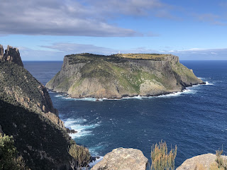
At the tip of the cape the trail divided and one way continued for another kilometre to an amazing chasm between 200 metre high rock columns that was almost scary to see
and a lookout over the island; in the other direction was a long flight of steps up the Blade, the highest point on the cape. That too was almost scary. The track had been busy with all the folks doing the official Three Capes but nobody else was climbing the Blade. Maybe they were advised not to.

I hardly stopped because I wanted to be done before dark, but I had a rest on the way back just where the track left the coastal views and on cue the sky darkened; the rain was only meant to come much later but it started before 2pm. Luckily it wasn't heavy and later on the sun came out again. I was pleased to get back to the old school trail and I saw some nice yellow and blue parrots, and a couple of wallabies venturing out early. I was pretty tired by the time I finished - this had been longer than expected. 33 kms

I reflected that while I usually regard Tasmania as a special place for its mountains, alpine lakes and rugged wilderness, on this visit I had only gone to beach places but they too had been good. Good different.

Maria Island, Tasmania, April 2021

I had never previously considered going to Maria Island but suddenly it became very appealing for a short hike. The entire island is a national park, supposed to have a lot of wildlife and it's small enough to see in a few days. I planned a trip visiting several interesting sights and I did not anticipate any mud whatsoever. 


April 18 I took the ferry across to Maria Island, put up my tent at the Darlington campsite (which was busy) and started the walk up to Bishop and Clerk, a pair of tall dolerite columns jutting out of the forest high on the east coast of the island. The walk was initially in a ferny glade alongside a dry creek, then climbed grassy hillsides above sheer cliffs, and went into dry forest. The uphill walking was easy and in sunshine (such a change from my last hike) until I reached a massive scree slope; at first I didn't realise there was a path carved across the scree and I scrambled my way up. The final part of the ascent was difficult on big boulders with large steps up but at the top there was an abundance of flat rock to sit on. There was a fabulous view of the two columns
and over a large section of the forested island, with a sheer drop off 600 metres to the ocean below my perch. Coming down I remembered that I had broken my ankle while descending a similar rocky peak and I was particularly careful to follow the signs, and I was happy knowing there were other people still on top. 

By the time I got back to the developed side of the island (by which I mean first developed in 1840 and finally abandoned by the 1950s) the kangaroos were out in large numbers and also some wombats and grey geese. 15 kms

April 19 I walked to French's Farm campground (site of a farm inhabited in the 1930s) via a little white sand beach and fern forest, with nice views of Mt Maria, her summit initially in a cloud, and dumped my pack in the abandoned farmhouse. 

Then I started the 20 kms out and back to Haunted Bay at the far southern tip of the island. At first I was on a sandy road in banksia forest until I reached the isthmus connecting the two parts of the island (just like Bruny Island). I could easily see the beach on each side and I wandered over to the ocean beach; it was a beautiful curve of dazzling white sand with Mt Maria as a backdrop.
Back in the melaleuca and casuarina forest I had a gradual climb followed by a really steep descent to Haunted Bay. Near the end the descent was over granite boulders and tricky. 

The bay featured huge slabs of granite, sometimes tinged with orange, and a very rough sea.
Across the bay I was looking at the cliffs of the Tasman Peninsula. I had a quick snack and turned back. When I reached the isthmus this time I walked on the ocean beach until it curved away from the direction I needed then went across to the mainland facing beach. Lo and behold it had a lot of seaweed for the first kilometre! This sand was also white and the waves lapped gently.

I was prepared for a crowd back at the campground as it was a large area with 3 toilets and 2 water tanks but there was nobody else there apart from 3 wombats eating seriously and, I later found out,  a million mozzies.
I think I saw a Tasmanian devil having a quick scout around my tent. 30 kms

April 20 It started raining before dawn and didn't stop until an hour before I left the island. I had breakfast on the farmhouse veranda and set off to test out my new rain pants. I took a route through the forest and the forest, as usual on a rainy day, was a nice place to be. The trail undulated on the lower slopes of Mt Maria (none of the mountain was visible) and later followed a pretty creek which I had to cross a few times on stepping stones. There was a weak attempt at mud in some places. I passed the ruined oasthouse and would have stopped for a break if it had still had a roof. I saw a flame robin and plenty of kangaroos and wallabies who clearly didn't care about the rain.

The rain became worse as I sheltered in Darlington with Bishop and Clerk, partly visible when I arrived, disappearing in the thick cloud. The pair of Cape Barren geese were still hanging around the campground. 12 kms. Total 57 kms.

South Coast Track, Tasmania


I had been thwarted in my attempt to walk Tassie's South Coast Track by the February lockdown so I decided to try a part of it as an out and back on my next visit. It was getting late in the year for this track and I was not happy to see a forecast showing a week of rain.

April 13 It was a cold morning, 3 degrees, and calm waters in the sheltered Cockle Creek bay, and soon weak sunshine as I packed up from my overnight camp and headed off across the peninsula to the south coast proper. The trail went into light forest, skirted a low mountain, some boardwalk, then out across a heathy plain surrounded by low forested hills. Then more forest, lovely ferns and that primeval Tasmanian feel on the climb and descent to South Cape Bay. There wasn't much sandy beach so I thought it was high tide, and the surf was big. I had views of mountains with a splattering of snow. 

Another climb in forest and my introduction to the local speciality: mud. I didn't like it but this was nothing compared with what was to follow. Some nice views down the coast, lots of misty headlands and the sunshine was gone. 

I arrived at South Cape Rivulet, a lovely area of sandy beach backed by forest and a wide channel of tea coloured water flowing out to the ocean. Except that I couldn't see where I could cross to continue the trail. There were some hikers there (who weren't crossing the rivulet) and we discussed where one should cross; meanwhile a girl arrived at the far side and after a good walk around she waded across but unfortunately I was busy making coffee and I didn't see her cross so I didn't know how deep the water was. Anyway I put all my gear into dry bags, took off my boots and stepped into the water. It was chilly but not freezing. I started walking across ok until I slipped on an unseen rock and fell, getting wet above my waist; the worst part was that I dropped my boots and they filled with water. I quickly stood up and finished the crossing (about 20 metres). Then I put my wet  boots back on but without socks as they were drenched. I realised I had lost my sunnies in the water, but there wasn't going to be much sunshine on this walk.

This episode had rattled me. Luckily I wasn't cold and I walked as fast as I could to generate some heat. I had a climb up onto the South Cape Range, and around 2pm I met a couple coming the other way; they told me I was headed for a lot of mud. They had started that morning from my intended destination, Granite Beach, and had been walking for 5 hours so I realised I may well not make it today.

After a nice interlude crossing a high valley on boardwalk I reached the mud. It was unspeakably awful for the next 5 kms.

It was often deep and sticky,  always unavoidable and provided me with all sorts of problems: my hiking poles would get stuck, they would come apart, my feet would get stuck and sometimes it took all my strength to pull them out. A few times I went in knee deep. The easiest parts were when I walked in the middle of a rocky channel, despite walking through ankle deep water; at least the bottom was solid. Tree roots made natural steps but were slippery. What I really disliked was that I had to concentrate so much on the mud that I couldn't pay attention to the scenery at all. I pondered why this hike gets such good press. The trail climbed to two more high points but zero views. By 5pm the light was already fading and I was still 3 kms from Granite Beach so when I noticed a tiny clearing that I thought I could squeeze my tent into I decided to stop. I found water in a little pool, I suppose it was just a puddle but it looked ok. After coffee, biscuits and dinner I put on dry clothes and was in bed in pitch darkness by 7pm. It was meant to rain and it hadn't yet so that was good. The wind was extremely loud but I was well sheltered from it. 20.2 kms

April 14 The night was windy and the wind must have switched direction because it suddenly started to give my tent a hard time. I couldn't sleep for the howling noise of the wind and only fell asleep when it started to rain. In the morning I packed up a wet tent and resumed the track without breakfast. As I had camped on top of the range my walk was downhill and I got some nice views at last, of islands off the coast. There were no other camping possibilities on the way down so it's good I stopped where I did. It still took me 1 1/2 hours to reach Granite Beach campsite, including crossing a plateau with grasses and low trees.

I had breakfast at the campsite. The trail went down to a waterfall on the cliffside

and I could see the sweep of the beach. It was not obvious where to cross the base of the waterfall. Big disappointment: the beach was all pebbles and medium sized boulders, and inland was in cloud. On top of this I had to wade a creek and the fast current plus gusty wind made this unpleasant. I walked the bouldery beach slowly until I reached sand at the far end. Then I climbed into fern forest and descended to Surprise Bay. There was mud but not too much, however the trail had some tricky bits among the tree roots.

Surprise Bay was a good surprise: a sandy beach with islands offshore and a hint of sunshine.

To continue on I would have had to wade yet another creek so this seemed like a good point to turn back. I sat looking at the beach for a few minutes until the rain started again and was blowing right in my face. 

I walked straight back to Granite Beach as it was too cold and windy to stop for a break, then further along I had a moment of blue sky, which lit up the fluted cliffs beyond Granite Beach. I endured the boulders and waded the creek and put up my tent at the campsite, where there was a little shelter from the wind. I could hear the ocean thundering away. I was cold enough to get in my sleeping bag at 4pm. This is very slow walking! In the night a spotted quoll came right up to my tent to check out my food. 11.4 kms

April 15 It was a rainy morning and I was reluctant to get up. I set out for a muddy day.

I had a steep climb and it looked as if the weather was brightening but when I reached the high plain it began to hail. This was only local hail because I could clearly see mountains in the distance although I could see little on the ocean side. At the top of the second climb I stopped for a break; I had walked only 5 kms in 3 hours. The wind was ferocious the whole time on the high parts but when I was low I couldn't hear it and the silence in the forest was wonderful. 
The going was a bit quicker on the way down and I was pleased to reach the boardwalk which indicated the end of the worst mud. The final 2 climbs were gentler and I saw some nice views of the turbulent ocean, just before it hailed again. I enjoyed the forest more this time, and I stopped to make coffee by a lovely creek among the ferns. Here I had a little mishap: the water was boiling and suddenly the whole stove and mug toppled over. So I had to start all over again. 

When I arrived at South Cape Rivulet it was clearly close to high tide and the water channel was much wider than before. The log where I had been sitting for my coffee break was under water. I was keen to cross more safely this time so I prepared myself for a long wait. There was a swell coming in off the ocean which added to the challenge of crossing and I could see that conditions had been easier last time. The far shore was nice and sunny for a while.

Then there were showers. A guy who had crossed half an hour earlier in chest deep water was standing on the beach and we chatted. After close to 2 hours, by which time I was cold with just standing still or sitting on the rocks, I thought I had worked out when was the best stage during the water flow cycle to cross; I bagged all my things, took off my thermal pants from under my rain pants so I could keep them dry and waded into the water at the shallowest moment. I crossed closer to the river mouth than before so the distance was shorter but I was at risk of being pulled by the swell, not out to sea but back to where I started. It worked well and I made it to the other side quite quickly but still briefly got wet up to my waist. I went straight to the camping area, put up my tent, changed into dry clothes, hopped into my sleeping bag and made a cup of coffee. Soon it was raining again and it rained most of the night. The wind was still howling. I had camped under a tree so I could tie my tent onto it and periodically bits of tree fell on me. 12 kms

April 16 I ate breakfast in my tent while it continued to rain then packed up and left the minute the rain stopped. It didn't rain again which was very lucky because my rain pants were still soaked from the creek crossing and unwearable so I walked in my thermal pants, the only dry pants I had.

I enjoyed the ferny walk to South Cape Bay via another little beach, and saw views of Lion Rock that I had missed on my outward journey.

At South Cape Bay it was high tide and I had to walk some of the way on the boulders above the sand; one wave caught me by surprise and soaked my legs. It had clearly not been high tide last time as I thought. It was then really windy on the cliffs as I walked across and I heeded the warnings to keep away from the edge.

I revisited the coastline views and when I got to the boardwalk across the heath the sun was shining. On the final stretch I stopped by a creek to make coffee without spilling anything. Even the last part was muddier than before. 12 kms

This was an interesting experience for me. I had a temporary feeling of dissatisfaction in the days after I finished because I turned back earlier than intended, but this was so obviously the right decision based on the continuing rain and the amount of water in the creeks. My crossing of South Cape Rivulet on the first day spooked me for the rest of the hike as I knew I had to get back across (there were warnings on the Granite Beach side which I only noticed on my way back). Overall I felt the hours of tedious slog were a bit out of whack with the enjoyment of fabulous settings, especially as I couldn't enjoy some of the fabulous settings because of the conditions. South Cape Rivulet and Surprise Bay were certainly some of the loveliest places I've been to.