I was keen to walk this trail because it sounded a bit different from the usual popular trails I do, more demanding but not impossibly hard. Also I liked the idea of going from A to B, in this case from Penguin on the north coast of Tasmania to Cradle Mountain National Park. The route has three distinct landscapes: the Dial Range, the Leven Canyon and the Black Bluff Range, each with its own character and challenges/difficulties. The walking club that cut the track in the 1970s and maintain it like to say that it is more than a 'sanitized' trail in the style of most Tasmanian, or Australian, trails (what they really mean is that there are no huts, toilets, formed steps or boardwalk on the route and some parts are downright dangerous) and it appears to attract only about 30 walkers who do the full 5 - 7 day distance each year.
22 January Penguin to Adit Creek (approx) 25.8 kms. I walked the road uphill out of Penguin to the trail's official start and took the alternative, 5 kms longer, route by going up onto the Dial Range and ascending Mt Dial and The Gnomon. Nice views of forested peaks and ridges and a rough scramble. Tyrone, who is my constant spiritual companion in Tasmania, only rates this bit of hiking a C, which is really a comment on the high quality of Tasmanian bushwalking. Back on the main route I came down into forest with tree ferns and I settled in by a creek for my first trail side coffee. Soon I was passed by 2 day hikers who explained they were related to the family who inspired the track and lake names of the area near Black Bluff where I would be walking in a few days. I got to the Leven River and walked the nicely named Lobster Creek Tramway along the river bank. He the river was wide, shallow and calm.
After lunch I had a massive hill to climb, the flank of Mt Lorymer, which went on and on until I got great views of the Dial Range and the coastline. This climb, I would soon realise, was just a small test and a warm up before I entered the Leven Canyon where the terrain would get serious. I intended to camp by Adit Creek where my route notes mentioned a suitable bit of ground but I didn’t see anywhere so I went on. For a while I pushed through head high ferns where I could feel the track underfoot but not see it. When I entered the forest and saw a patch of flat ground I immediately decided to make use of it, as there was a gurgling creek that I had recently passed.

23 January To Blackwood campsite 21 kms. It was warm and sunny, for which I was grateful as I would be starting the treacherous walk through the Leven Canyon, a place where dry ground would definitely be the better option. I made a steep descent to a lovely creek where I had breakfast and then I had several hours of easy walking, first on forestry roads where I saw a huge black snake, and then on the sealed roads across Gunns Plains. I was alongside the Leven River which was still calm and bucolic. It was hot work and I tried not to stop much.

I reached the trail into the canyon and was immediately forced to slow down, with short steep scrambles on loose dirt, loose rocks and some wet creek crossings. On one of these I fell when my pack suddenly swung off one shoulder and I didn’t like the drop I saw below. I was on the lookout for one especially dangerous section I had read about but there were several stretches of track that seemed unsafe due to sheer drops over cliff edges towards the river far below. There were intermittent fabulous views down to the river and even some easy bits at river level through the forest.
Really it is amazing that someone can have thought it possible to cut a trail through here, and the nature of the terrain means the trail is very very narrow. When I came to the section after Tulip Tree Creek that I had heard about, a grassy embankment maybe 10 metres long with a sheer drop, I did not find it that scary until I turned around and looked at where I had just walked.
It took a long time to reach the campsite with many obstacles along the way, loose scree, sand and I was sure I must have passed it. But I got there eventually and it was a delightful clearing in the forest with blackwoods and ferns.
24 January To Leven Splits 8 kms. This was an amazingly slow paced day for me, covering this distance in 7 1/2 hours and feeling exhausted afterwards. Sometimes the trail was extremely easy just following the river bank
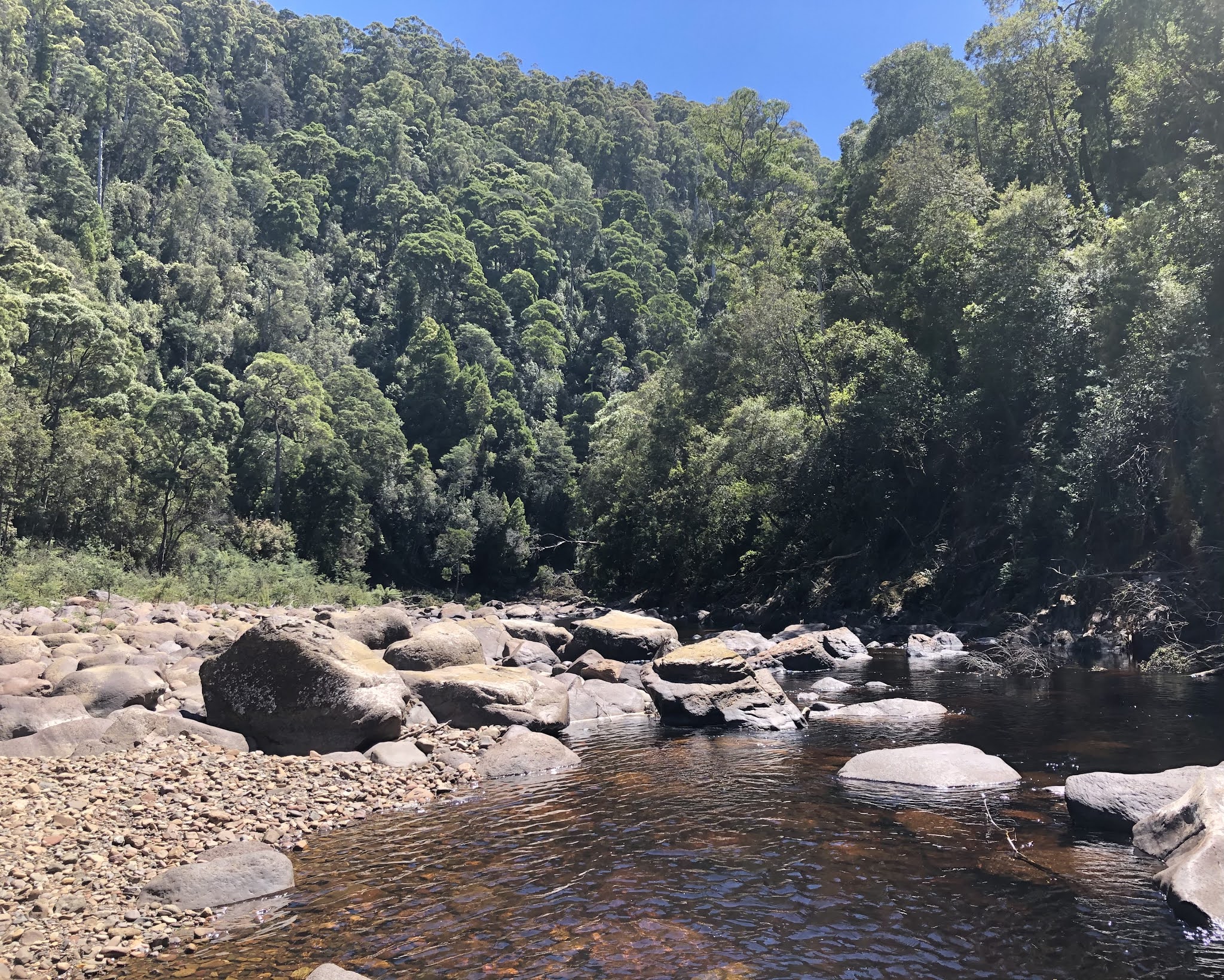
but it wasn’t often this straightforward. I had incredibly steep slopes with loose rocks or loose dirt where I slipped over and cliff crossings, some of which featured a long drop off to one side. There was often nothing to hang onto. The trail was well marked but there had been landslides and I came across plenty of fallen timber; some of the logs were so huge that it was hard to get over them even when a few notches had been carved for help. At one point I had to cross several rocky outcrops that were in the river (I scouted this out without my pack before doing it properly) and I was fortunate that the river level was low. Another time I had to use a thick rope to pull me up a slope.

Having followed the river for a while I then had to climb up out of the gorge to Griffiths Ridge, following a route that was right beneath high granite cliffs. I could see farmland and forested mountains beyond the ridge. I went up and up until I was 300 metres above the river. There was a little track to a lookout where I clambered on shaky slabs to peer down at the river and the Leven Falls and sheer rock faces across the gorge.
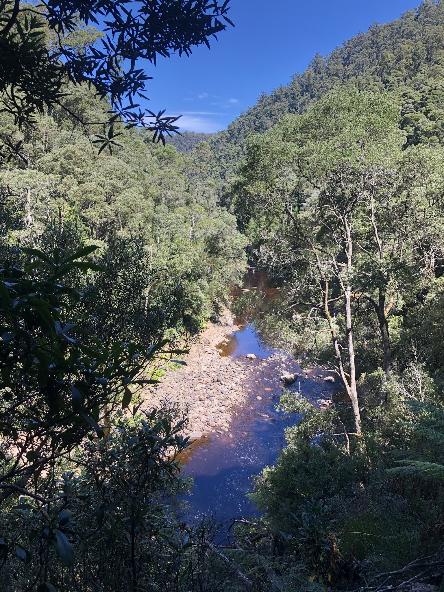
The descent was not pleasant. It was steep and twisting and slippery. I was most surprised to bump into two walkers who were heading from the Falls car park to Blackwood campsite apparently as a return day trip; they were horrified when I said I was 5 hours' walk from Blackwood at that point. I got right back down to the river and sat for a while above the falls. The river makes a surprising right angled turn here and the track took me to a bridge across Leven Splits where the river torrent is dramatic.
I stopped at the first possible campsite, among fern trees and by a pretty pebbly beach on the river, which was now tranquil again. I was now exiting the gorge and the PCT was going to begin its third phase, hopefully with less danger but I knew there were big climbs ahead into the alpine lands.
25 January To Paddy’s Lake 11 kms. My day started with a steep climb into a forest of ferns. The ferns were taller than me and completely obscured the track so I had to follow the orange markers on the trees and feel for the track underfoot. But it was a beautiful place, so vividly green.
I had a bit of road walking and then crossed the Leven River, said farewell, and embarked on the relentless 3 kms climb up Black Bluff. I went up Black Bluff last year with Tyrone's promise of an A grade walk but the weather was bad and I had no view at the top. This climb, through ti tree, goes on and on with very little of interest until you reach Paddy’s Lake sitting on a shelf below the peak. I had a few spots of rain and hoped the weather would not worsen.
I planned to camp by the lake so I dropped off my pack and continued up the rock strewn trail to the summit. It was becoming really windy. At the top I couldn’t find any shelter from the wind except by ignoring the view. The view towards Cradle Mountain and Barn Bluff was wonderful but I didn’t linger long.
By the time I got back to the lake the wind was much worse so I thought I had better put up the tent. I held on tight so it wouldn’t blow into the lake and tried to hold the ends down with rocks but there weren’t many rocks there. I got inside fairly soon. There was no question of being able to cook so I ate wraps with tuna. In the night the wind was ferocious and the tent flapped like crazy even though I had tightened everything as much as I could. A bit of rain blew in under the fly but otherwise the tent passed its first serious test. I didn’t sleep much because of the noise of the wind and because I was concerned that I was too close to the lake and might end up in it.

26 January To Fourways 20 kms. I had to make a decision first thing whether it would be ok to carry on as I had to cross alpine areas where it would be dangerous in low visibility, but my decision was coloured by feeling that it would be too unpleasant to spend a day by the lake in the still strong wind. I could see as far as Black Bluff so I thought that indicated I would be able to go ahead. I took down the tent very carefully, again so as not to lose it, and left the campsite without breakfast, planning to stop at the next campsite after 9 kms, where I could again assess the day.
The first few kms were quite miserable as I trudged along a sodden path, more of a creek really, and brushed against endless spiky scoparia bushes. I was climbing along the Black Bluff Range but I could see nothing, although I had no problem following the route marker poles. Luckily very few of them had fallen over or broken. It wasn’t raining but the wind was cold. I cheered up when it appeared the sun might come out and the clouds seemed to break up, but this never lasted, however my cheering up did last with my forward movement; nobody wants to be stuck for a day in a forlorn campsite.
As I approached Bare Mountain campsite (the name says it all) the weather really was improving and I could see hillsides around me. I stopped for breakfast at the campsite. When I left I was soon startled by a skinny grey snake on the trail. The outlook improved considerably as I walked along. I was in typical Tassie alpine scenery: button grass, strewn rocks, mud, low bushes and distant peaks. I had views of Cradle Mountain and one fleeting view of Barn Bluff before the clouds swallowed it.
I crossed the Cradle Mountain road and continued sidling a series of peaks. The route was undulating without serious hilliness. I could look down on Lake Lea (very large), Pencil Pine River (flowing fast) and a lot of moorland. Then I passed under the bulk of Mt Beecroft, which I would have climbed in better weather. I had a lengthy zigzag down from the heights and meandered along to Fourways campsite.
The campsite was tiny, surprisingly, with an alcove for a small tent and a small dining/cooking area. Perfect for one person and I was not expecting company. The log book showed the last person had been there on 6 Jan (not a PCT walker). In late afternoon there was finally a hint of blue sky.
I did get a visitor in the night, though. A small animal, maybe a quoll, tried to grab my pack from the vestibule. This gave me a chance to admire the night sky and this was my only night sky with stars.
27 January To Cradle Mountain ranger station 10 kms. I had a perfect bluebird day for my last day on the trail. I crossed a river junction at the real Fourways and continued into myrtle forest. It was lovely with the dappled sunlight. I had the greatest navigational problems here of the entire trail, it’s hard to see why because the route was easy and well marked but I several times found myself off the trail and once I was going backwards! The only obstacle was a nasty log bridge crossing with a hand wire that was in such a position I felt it was pushing me off the (high) bridge as I walked across.
I came out onto Speelers Plains, a 3 kms expanse of button grass to cross. I stopped by a creek in the beautiful weather to lounge and drink coffee, although the wasps and March flies dampened my fun. I had a great view of part of Cradle Mountain.
Then I returned into forest for the final push. I soon came to civilisation in the form of a boardwalk amd then the paved road. The trail seemed to end there but with no official sign (in keeping with the nature of this trail I guess) so I decided to make my own finish line and I walked on to the Cradle Mountain National Park ranger station a few minutes away. Done. There was a shuttle bus conveniently waiting there to take me to the main visitor centre where I could organise my next activity. I had lunch there and booked a hotel room - another 2 kms to walk!
The following day the weather was still perfect, although a little windy, and I decided to do the overnight Lake Rodway hike. I had wanted to do this for a long time. It’s only 16 kms the whole loop and I planned for a very short first day and then to sit in the sunshine at the campsite.
I took the shuttle bus to Dove Lake and started from the lake shore, soon leaving it to climb towards Hanson Peak. This was to be a day of many lakes. First lake: Hanson Lake:
The path undulated a fair bit but I wasn’t going over the peak. Another lake:
Then the prettiest lakes of all, Twisted Lakes. Two were to one side of the trail:
and there was a third one below Little Horn:
After this I had a long downhill to Lake Rodway and walked along the lake to the campsite by Scott Kilvert hut. Just in case, there was a helipad by the hut. I put up my tent on the sleeping platform furthest from the hut and spent a nice afternoon lying on the platform reading a book on my phone. I was directly beneath the back side of Cradle Mountain.
In the night the wind really picked up and by the time I got up it was so strong I had to go and cook/eat breakfast inside the hut. I walked initially in forest and then on the open tops climbing away from the lake. I couldn’t see Cradle Mountain at all and the lake looked black against a backdrop of faintly visible mountains.
I stayed on the tops for a while until I joined the Overland Track heading back towards Dove Lake. There was little visible but I did get the view over the Fury River gorge far below. The track was increasingly sodden but there was plenty of boardwalk but sadly I was heading directly into the fierce wind. I passed several day walkers who did not look at all happy or well equipped for the conditions. I was pleased to reach Kitchen Hut and I went inside to make a cup of coffee. This hut is a new replica of the hut we sheltered in on our first ghastly day on the Overland Track in 1985.
I stopped briefly at Marions Lookout then took the very steep Link Track down to Dove Lake. From there I walked the lake shore, passing the boathouse, back to the shuttle bus.
The weather was better the next day but not great for views. I did a loop from Ronny Creek past Lake Lilla and Wombat Pool up to a viewpoint above Crater Lake and returned on the Overland Track. In the late afternoon I went back to Ronny Creek to see the wombats that come out of their holes to feed when it cools down. Most of them kept well away from the boardwalk but a few seemed to be keen to stay near it.
The following day I did an out and back from Ronny Creek on the Horse Track to Crater Peak. This was a long steady uphill but there was nobody on the trail. At the top I was surprised to see several groups of walkers. There was a good view over Crater Lake and across to Dove Lake.