I haven’t been able to achieve all my goals for this year due to the long lockdown and continuing border closures, but I realised that I could do the rest of Walk the Yorke this year with some careful planning and I would be allowed to say I have through hiked it. The difficulty with this hike is coordinating access to start and finish points on public transport as the buses are infrequent. I had the east coast and the west coast of the peninsula to do, above the “foot”, and I would have to do both in a northbound direction to fit in with the bus timetables, so Edithburgh to Port Wakefield on the east coast and then Port Minlacowie to Moonta Bay.

November 30 I left Edithburgh in much better conditions than last time, it was going to be a very hot day getting to 32. It was a little windy and masses of flies. Trail was initially by water, extensive rock flats, then across a causeway then road into Coobowie. I had a cup of coffee at the cafe, not because I needed it after less than an hour of walking but just because I didn’t like to miss an opportunity. It was a typical very spun out Yorke settlement to give every house a sea view.
The grain depot and jetty at Port Giles I was heading towards dominated the view and when I got there it was a huge operation: trucks lined up to deliver grain were waiting three deep. I had a pleasant cliff top walk into Wool Bay,
a line of houses, where I rested a bit. I could see Kangaroo Island as a feint silhouette. After that I saw my first kangaroo and then had a long 9 kms stretch on roads. At first I was by a busy road the grain trucks were using and I climbed over a fence to walk at the edge of an unharvested field instead but then I had to walk on the road until I could turn off onto a quiet dirt road. This was all a detour to avoid a cement works and it was great to come back to the water eventually.
I was pretty tired by then but I pressed on until I could go down to the beach. This was the first sandy beach I’ve come to and it was covered in seaweed. However I found the seaweed ok to walk on. I sat for a while watching the grey herons and black swans. Further along I saw a crowd of pelicans.
Stansbury ahead looked like a green oasis with Norfolk Island pines along the seafront. The place featured a big bay with a strip of sandy beach (just sand as it was high tide so the rocks were hidden) and picnic tables above the beach. I checked into the caravan park and got a waterfront site. I went into the shopping area to get some lunch then realised I’d forgotten my mask; I thought I could sneak into the IGA and buy something quickly, which I did, then after I paid I was asked if I had a mask exemption. I had fish and chips for dinner sitting by the beach watching the little swallows and wagtails darting about. 30 kms
December 1 Wind was strong in the night and tent flapping disturbed my sleep. As I walked out of Stansbury I realised I was going to have a good tailwind, but it was quite a cool wind, and a cooler day. For the first half of the trail I had to walk inland alongside the main road, although on a path separated by wattles and mallee gums, by harvested fields. One field had a lot of sheep who were dotted around feeding in large groups; one member of a group would see me, turn and run away and then all the others in the group would jog along behind in single file.
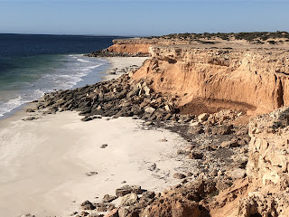
When I returned to the coast the wind was worse, coming straight off the water. But the scenery was great: high red cliffs and almost white sand.
There were a succession of coves but unfortunately not all were accessible on foot and I had to walk mostly on the cliff top. In the windy conditions it was more comfortable to be away from the water. When I came to a rest area just before Devils Gully I had a wee and a cyclist with terrible timing came past, the only person I saw on the trail all day. Devils Gully was an impressive incision in the cliffs and had a hikers shelter. I sat on the ground where I had the coast and gully view but was out of the wind then realised I was sitting on ants. I didn’t make coffee due to the wind. I could still dimly see yesterday’s grain silos.
Then I opted to walk along the beach into Port Vincent; the tide wasn’t really low enough to expose much sand and I had to walk on the uneven rocks. Port Vincent was more lively than Stansbury, with a nice sandy beach on the side of the promontory where I stayed and extensive tidal flats on the other side. I went to the beachside kiosk for coffee and donuts, a perfect sheltered spot. 18.5 kms
December 2 Wind continued to rage all night and again all day. Leaving Port Vincent
I climbed above the town and had a very nice cliff top walk even though it was alongside a road. The path wound in and out of bush, full of honeyeaters, with great views of the cliffs. I came to a golf course, magnificently situated
but with the yellowest grass and looking completely neglected. After that I was supposed to walk on a roadside; the walk people had taken a leaf out of the Heysen manual and created a narrow path between 2 fences which didn’t appeal to me at all, so I walked down the middle of the road. It wasn’t the Hume.
Another cliff walk led me into Port Julia
where I had intended to camp, but I wasn’t ready to stop for the day after only 15 kms and it would have been hard work trying to relax with the awful wind and anyway I didn’t see a campsite. I boiled water in the toilet block to be out of the wind then sat in the historic red shed by the jetty to drink my coffee and eat my nutella wraps, taking the full brunt of the gale.
Suitably refreshed I went on with several kms on the beach. It had lovely white sand and I soon observed that something was missing: there was no seaweed. As usual along this coast there were tidal flats and a few clusters of birds hanging out. It was fast walking with the tailwind but every time I looked back at the view I thought I would be blown over. At Black Point I left the beach to walk through parkland where it felt much hotter, and I finished up with a road walk to Pine Point. Looking back towards Black Point the beach was dazzling white. The caravan park at Pine Point was small and not patronised by any of the enormous rigs that fill up most of these places, so that was a nice surprise. I enjoyed an immediate tub of hot chips as the only shop was about to close. 28 kms
December 3 The wind dropped a little in the night and was a pleasant breeze by the time I started the cliff walk north. Although the way I was tackling these two sides of the leg of the peninsula might seem convoluted and was purely dictated by the bus schedules, it had turned out well with the tailwind. I stopped at a hiker shelter only three kms from Pine Point and had a coffee looking out over the Gulf St Vincent beyond the mallee covered cliffs. This was a lovely peaceful spot: blue water, green treetops, yellow grain fields behind.
I could feintly discern the Adelaide coastline across the gulf and to the north I could already see the Ardrossan grain silos. Unfortunately my stove became welded onto the table and after much effort to wrench it free I left a decoration smack bang in the middle of the table. Sorry about that.
After a couple of hours up on top and after crossing some untracked gullies I went off the curriculum and decided to continue on the beach which was mostly sandy. There were again extensive tidal flats and I could see it was possible to walk on the beach beneath red and yellow cliffs to Rogues Point, a shack village. Unlike yesterday there were no white caps on the water and I had only a light tailwind rather than the constant gusts.

A few people were in the water crabbing and a woman returning told me she had caught 20. Rogues Point was a much larger place than it at first appeared (many of the beach settlements are reasonably large but don’t have a shop) and I soon got fed up walking along the road past houses so I went back onto the beach. The cliffs were replaced by low dunes and I walked on seaweed but it was nice and firm for walking. I came off the beach at a free camping area by a memorial to seven beached whales where I carelessly stepped into gloopy sand and got wet yucky feet. After that there was a 5 kms roadside walk, past the grain depot, into Ardrossan. It felt a very long way, the least entertaining so far, despite a water view all along, and then once I was in the town I had to walk right across it, past the bakery, to reach the toilets. Next I walked all the way back across town to visit the bakery, showing dedication to duty. It rained a bit and I had a nice chat with a long distance bike rider camped at the caravan park. 22 kms
December 4 The stronger wind was back, still a tailwind. I left Ardrossan on a sealed cliff top path for a couple of kms to the beachfront settlement charmingly named Tiddy Widdy and then walked a dead straight trail beside a dirt road for several kms. There was native bush beside the trail. I turned off to cross an area of low vegetated sand dunes which was great for a change although the soft sand track was hard. Just past the junction I saw a Sleepy Lizard (like a truncated goanna) among the plants; it kept motionless while I took a photo but then decided I had been staring for long enough and stuck its tongue out fiercely.
The vegetation was tea tree, wattles and lots of onion weed. I was hoping for more wildlife since I saw plenty of animal tracks and finally a kangaroo jumped across the trail.
I turned inland on a dirt road and came to a hiker shelter that was not on the map; at exactly half way for the day this was a pleasant surprise. I braved the wind to sit and drink coffee; being flat in every direction there was nothing to break the force of the wind and it was cool.
The second half was on a dirt road and I had fields to my left and samphire flats to my right with quite a collection also of two species of delicate lilac coloured sea heaths, ruby saltbush, noon flowers. One time I surprised another Sleepy and I was amazed how fast it scurried off. I had a long stretch alongside salt lakes and crystallisation ponds. It was getting very warm as I came to Price, which had nothing but a caravan park and a pub: all I could ask for. 20 kms
For something to do later on I walked the 1500 metre causeway across samphire and mangrove tidal flats towards the coast and to my great surprise I came to a wide mangrove lined creek at the end of the road. Also Price looked more attractive from this side, a slightly elevated cluster of old houses.
December 5 My tent was covered in mozzies in the morning and they hung around me in a cloud, also biting me. I left Price to follow a trail at the edge of the samphire/mangrove flats which were meant to be full of shore birds but I saw none. Half way to Port Clinton the trail climbed onto the cliff top for a great view over the flats and I could see plenty of pools of water.

From Port Clinton I had a long hot walk, having to make a big detour away from the coast for no obvious reason. The route headed inland with a long gradual climb between wheat fields and views of wheat fields in every direction. This was the only sustained climbing, about 200 metres, I’ve done all week. Behind I could see PC stretched out along the gulf and it never looked as though I made much progress but I felt I had been going for ages. Without a breeze it was really hot and the flies were bad. I came closer and closer to a hill I had been able to see since yesterday, South Hummock, which describes it well. Finally I reached Port Arthur hiker shelter, right on top of a hill so extremely exposed and windy. Straight ahead of me I could see the head of the gulf with a thick border of mangroves. That made me feel I had come a long way this week. I took a good break, was pleased to find the tap on the water tank that I had read was broken had been repaired so I could get water, and put on my head net against the flies for the first time.
The last 5 kms back down to the coast and the campsite I was aiming for was into the wind. I hadn’t expected much of the campsite, being one of the free roadside places, and I was right; it was beside the Yorke Highway, on the edge of a conservation park, with no facilities and much litter. I found a patch of sand to camp that was sheltered from the wind by small trees with tiny ants everywhere. Ha ha they couldn’t get into my tent. I cleared the litter from the view I had as I lay in my tent so I was looking out over pig face, mallee and wind blown grass and it wasn’t too bad apart from the rather incongruous traffic noise. Several van lifers showed up. 27 kms
December 6 The mozzies were diabolical, covering the netting of the tent and starting a feeding frenzy on me when I emerged outside, so I had breakfast inside and left as soon as I could. It was already hot before
8am and cloudless. I wore my head net all morning (for the mozzies and then the flies); the sort of gear one would laugh at but it does an excellent job. The trail crossed samphire flats all the way to Port Wakefield. At first I was parallel to the highway but it wasn’t intrusive and I had a view of what I presumed to be North Hummock as well as South H. About an hour in I noticed footprints on the trail which surprised me but all was explained when I saw someone in a hi viz vest up ahead. As I reached closer I initially saw the person was seated on a bench and then saw he was a mannequin dressed as a worker; he was a great likeness but sadly his companion was strewn around the sand.
Nothing so exciting followed. The trail turned towards PW and led there in a straight line for 8 kms across the samphire. In one area there were sheep - slim pickings among the samphire I would think, although some samphire can be cooked. I know this because the first time I googled samphire I got a bunch of recipes. Then just hot walking until I reached the tidal inlet near Port Wakefield. There was a brand new bridge across the inlet; great, because the ankle deep water looked horrible. At this edge of the town was Wakefield River with nicer water but no water fowl, and a sign about Walk the Yorke. A couple got out of their caravan to study it and I didn’t want to miss an opportunity to tell someone what I had just done, so I told them and they asked questions. I had to choose a finish line for my hike and I saw a bakery on the map which would be perfect so I walked up the main street towards it; as I went I worried that it wouldn’t be open as all the buildings had looked derelict when I came here on the bus a week ago, then I cheered up when I spotted someone carrying bread. The place was hopping with activity and I was able to have a long rest there, my east coast done. 15 kms
I had taken a day less over this coast than planned, and to fit in with the bus I needed to take to do the west coast I was left with sufficient time to spare to make a short visit to Wallaroo north of Moonta. The bus system being what it was, I had to return to the east coast from Wallaroo to get my bus back to the west coast for the final blitz.
December 8 After a very long day in Port Wakefield I finally got on the bus to Brentwood, the nearest point on the bus route to Port Minlacowie where I had stopped walking the west coast of the Yorke peninsula in March. All I had to do now was walk north up the Spencer Gulf to Moonta Bay.
I got off the bus at 7.30pm and I had a strong headwind walking up the dirt road to Port Minlacowie campsite so I made excellent time. I had my tent set up and a modest dinner of a roll with PB consumed before dark. And a lovely sunset. It felt so great to be back here and I camped among the bushes which were full of little birds. 5 kms
December 9 I left my campsite early and had breakfast at the hiker shelter, my most northerly point in March. The weather was windy, soon became muggy and remained overcast. I had upset my back with walking so fast the previous evening. I had a short beach walk then several kms on sandy tracks and through grassy places where my socks became full of prickly seeds. The next beach section was seaweedy and hard to walk. But I had a nice beach walk to Barkers Rocks, white sand and rock pools and not too much seaweed. At the shelter I stopped for coffee, already 15 kms by 10.15am and a prospect of sunshine.
The next hour was across the back of the dunes in a conservation park with some nice flowering veg: dune fan flowers, boobiallas, goodenias, and everlastings. I had to cross the dunes to get to Point Rickaby which turned out to be a sleepy small place with an attractive timber jetty.

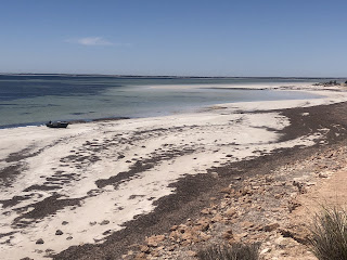
My last 10 kms was along a sandy beach with a vast area of rock pools so that I could barely see the ocean, later on the rock pools were replaced by sand flats. It was a wide open empty place and really confirmed for me how dissimilar the two coasts are; the west coast seems much more spacious and wild. I saw lots of hooded plovers and sooty oystercatchers. The wind was becoming really strong and seaweed sometimes got wrapped around my legs. I had decided to camp at Wauraltee campsite just above the beach or at the hiker shelter a little way inland; the campsite was busy and I couldn’t find a nice spot so I camped next to the shelter. It was a real struggle to put up my tent as the ferocious wind seemed to keep changing direction and I couldn’t get the fly up at all and lay inside without it, but with a good view; much later I tied the fly awkwardly to trees so it kept some of the chill of the wind away. 32 kms
December 10 When I woke up I couldn’t believe it: not a breath of wind. Didn’t last long, of course. I returned to Wauraltee beach and walked another 10 kms along it. This stretch was great, just a huge expanse of white sand which looked beautiful even on this dull cloudy day. At the end of the beach, separated by a low headland, was little semicircular Rifle Butts beach.
I stopped to buy food in Port Victoria and sat near the jetty for a while as the weather was improving fast. The next 22 kms was a long haul. After a few minutes above the beach the trail went inland to follow a dirt road and then a sandy trail across grassland with isolated bushes and larger areas of samphire. There was no shade, few birds and a lot of sun and my back had started getting sore again. I had lunch at Point Pearce shelter, quite a desolate place. The only scenery of interest were salt lakes of dazzling white and the backside of some dunes. The headnet got a workout. It was a relief to finally reach Balgowan and I rested for a long time at the caravan park next to the closed down shop. (After trudging all those kms it would have been awful to see the shop and not to know in advance that it had closed.)
The next part of the trail was one of the best of the entire trail and what made it even better was that I had no idea this was in store. I left Balgowan on a cliff top path and the cliffs were magnificent: high, red and with white sand beach after white sand beach below.
I was going to stop only a km out of town at the hiker shelter but it was right by the road so I continued on the cliff path to Tippara Rocks campsite and I found a spot among the dunes, completely to myself. I watched the sun set over the Spencer Gulf, a surprisingly chilly activity with the cold wind. 38 kms
My food intake hasn’t been super healthy today: a roll with PB, a Picnic bar, a large cookie, an oat bar spread with PB, instant noodles with baked beans, another oat bar, 3 coffees.
December 11 This time the wind did not die down overnight. I hoped to get all the way to Moonta today and finish the trail but this would mean another very long day. I wasn’t confident there was anywhere to camp before Port Hughes and that was almost Moonta. When I started out I wanted to stay on the cliff path but it ended at the campsite and I had to take a sandy inland dirt road 8 kms to the Gap where there was a hiker shelter. I loaded up with water and embarked on the 27 kms beach walk to Port Hughes. I thought six hours would do it and that was daunting; it took a bit longer, which I was happy not to know at the outset. This was definitely the most remote part of the entire Walk the Yorke with no facilities whatsoever and I was concerned because it was forecast to be extremely hot, but I felt a lot better when I saw that there would be some people around; every one or two kms during the first few hours there was someone fishing or riding a dirt bike or chilling under a tarp. I was lucky with the tide which had been high
at 7am so I was guaranteed firm sand for the day. The beaches were white and the sea a lovely azure so the walking was fun and I pushed along at the water’s edge as fast as I could. When I got to Cape Elizabeth, roughly half way, I left the beach to get a view from higher up and I thought I could just see Moonta a very long way away. (Actually this was only Port Hughes.)
The second half of the walk was a shock. Gone were the beautiful beaches and in their place were endless gloopy sand flats with slimy pools and seaweed in all stages of decomposition, and it was impossible to walk on this. Fortunately I found the sandy trail used by the dirt bikes and was grateful for its existence; it appeared from my gps that I was meant to use that trail but there wasn’t a single Walk the Yorke trail marker after the Gap. This trail was hard to walk on as it was soft sand and the tyre channels were too narrow but I plugged away at it, intermittently walking over seaweed. I could barely see the water, just samphire and seaweed. I saw a flock of cormorants and a lot of hooded plovers (which make a surprisingly loud noise for such a tiny bird) and red capped plovers and some swans. Eventually I returned to normal beach walking beside dunes. When I looked back I could see Cape Elizabeth and I was amazed how distant it was, so how far I had come, yet I had already walked for hours by the time I was there. Gradually I approached Port Hughes - I could see the jetty from several kms away - and I decided to stay at the caravan park there as it was by the jetty and I was exhausted, but the office was closed so I couldn’t book a site. I spotted the general store and went in for a cold drink and chocolate and a finger bun. I was spent. (In a way I was pleased I couldn’t stay there because I was still worrying about being pulled off the track by the covid police and it would be sad not to complete the final half hour of the trail.)
Then I continued 3 kms to Moonta Bay, after booking a site at that caravan park by phone. At first I walked on streets, which I liked after all day on beaches but then I had to go along the beach.
It was after
5pm but it was still hot. When I got to Moonta Bay jetty I was able to say that I have completed Walk the Yorke.
I was hot and quite shattered when I reached the caravan park and not at all happy to find there was nowhere to eat or buy food. Luckily I had taken an extra day’s food on the trail, but this was not the celebration I had anticipated. 38 kms
After I was done with the Yorke I went to Adelaide. There’s a bit of the Heysen trail when it passes close to Adelaide where accommodation is a problem and I would have to come into Adelaide, so I thought I might as well do this stretch as a day walk from Adelaide. Out of sequence, I know, but I had a space in my schedule as I had rushed along the Yorke. (I had rushed along the Yorke so as to lessen my risk of being yanked off the trail for covid reasons.)
December 14 I took the bus to Bridgewater and started my hike on the Heysen to Mt Lofty. Everything was so green. The trail started by a creek running through an overgrown area and I saw some parrots (Adelaide rosellas, of course) almost immediately. I’ve been up Mt Lofty (727 metres) several times so I wasn’t all that excited but it was a lovely day and the view over Adelaide was clear.
As I descended and worked my way towards Norton Summit (442 metres) I remembered this part of the trail very well from my last visit; the Heysen and the Yurebilla trails coexist along here and I ran the Yurebilla over two extremely hot days in 2016.
Not only did the heat make the running difficult, there were not enough signs and this was before the days of gps so I went wrong repeatedly. This time I was never in doubt which way to go and it wasn’t quite as hot, only high twenties, which was still pretty warm. The trail sidled the range in forest with almost continuous views over Adelaide and back across to Mt Lofty. I saw more rosellas and heard lots of kookaburras. In Horsnell Gully conservation park I descended steeply on slippery single track and once at the bottom I had to come straight back up on an unrelenting dirt road in Giles conservation park. It was a still day and nice to be surrounded by tall trees. There were many views of vineyards, very leafy and green.
Norton Summit village was as sleepy as last time apart from fast traffic coming through. I sat outside the pub and planned the rest of the hike. I would happily have ended the day here but there weren’t any buses back to the city and I had to work out how far to continue along the Heysen so as to minimise the distance I would have to walk off the trail to get to a bus stop, bearing in mind that I would have to retrace my steps when I returned to the trail. I thought I had it sussed and I headed into Morialta conservation park, although it was already
5pm and I was slightly concerned whether my plan would work, since trails shown on maps on the phone can be fictitious. Last time I thought Morialta was the gem of the Yurebilla and again I loved it. After the Third Falls, which were flowing into a pea green pool, I came into the gorge and was again struck by the high cliffs among the trees. In places there were everlastings and bluebells and guinea flowers. This park is far more rugged than the other Adelaide Hills parks.

(It’s so good that I went back the next day and did the Second Falls walk, getting to see the First and Second Falls which aren’t on the Heysen. First, Second and Third Falls on Fourth Creek - how’s that for naming? I think I was fortunate to see all the falls in action.) At Deep View lookout I parted company with the Heysen/Yurebilla and headed out of Morialta along the mostly dry Fourth Creek. To my great relief there really was a bus stop at the edge of the park. A bus came within two minutes and took me back to Adelaide. 30 kms
December 16 I had a final task for the Adelaide Hills: the Pioneer Women’s Trail, which I wanted to walk from Beaumont on the edge of the city to Hahndorf, where I was staying. Uphill, I know, but it was going to be a 30 degree day so I wanted to be in the cooler parts as the day warmed up.
As I climbed sharply through Burnside and on into Cleland conservation park on an exposed dusty trail it was already hot and hard work. I think I was here before when I ran the Cleland 50km in 2018. The views towards Mt Lofty were good, lots of bright green and bright blue, and nice to look down on Adelaide and see how much I’d climbed. I soon recognised some of the trail as it was part of the Yurebilla, a part where I had serious navigation problems. I also recognised a bit of the route that was not on the Yurebilla but I don’t know when I was there before.
When I reached Crafers the climbing was done and I had a long downhill to Stirling, where I had morning tea at the bakery. The route continued downhill through Hills suburbia until I rejoined my Heysen route from two days ago, but going the opposite direction, through light forest and along blackberry infested Cox Creek. I emerged by Bridgewater Mill and stopped for lunch at a cafe right next door. It was a very pleasant temperature, slight breeze and not a cloud in the sky.
Soon I parted company with the Heysen, following the creek and then crossing it on stepping stones, and then went along streets (now hot). In the last three kms things got tricky as the route was by the main road and for a while there was not even a shoulder to walk on. The trail was no longer signed and this stretch appears to be an ongoing issue. I was tired and Hahndorf seemed elusive, but I made it to the Pioneer Memorial Park and called it a day. 23 kms


 I came upon a fat lizard resting on the trail, completely motionless. Closer to the top a black snake was lying across the trail; it was so still I wasn’t sure it was alive and a fly was sitting on its tail, but then it slithered away. The entire 11 kms climb took me five hours. When I reached the highest summit I had great difficulty finding the start of the descent and I was very relieved when I noticed a hairpin trail heading steeply down. This trail was loose dirt and really slippery so of course I immediately fell over and collected a lot of grazes and bruises.