
With the restrictions being modified on how far from home we are allowed to venture it was time for another of my trips to Portsea where I do the trip in sections and come home every night. Walking rather than running. I decided to take the bayside coastal route to Blairgowrie then cross the peninsula and go on the back beaches to Portsea, and finish with the walking tracks of Point Nepean National Park. 120-ish kilometres, six days: just the thing for a recovering broken ankle and more importantly to replenish the spirit of someone who likes to take on multi day projects.
This time, rather than starting from home, I had a new starting point in Beacon Cove, at a street whose name I found appropriate: First Point. I had some trouble finding it as it was only a tiny lane between apartment blocks. From here I went past Princes Pier and Station Pier and along Beaconsfield Parade to St Kilda Pier where we met up for coffee, Denis, Tash, Sophie and me. The coffee fired me up and I positively zipped along the coast path through Elwood and Brighton, which I later regretted because it was getting well past lunchtime and there is nowhere to get food on the path between Brighton and Sandringham. I was intending to stop in Sandringham but I kept going to Half Moon Bay where I sat by the beachside kiosk with coffee and a cookie. From here it was only a short way to Black Rock where I called it a day; 20 kms done and the furthest I’ve walked since September.
The second day the weather was beautiful and everywhere was busy. Between Rickett's Point and Mordialloc I took a mixture of beach, bush tracks and sealed footpath. I stopped in Mordy for coffee, then started out on the long push to Frankston. I’ve always run by the road in the past but I didn’t enjoy walking there so I went down a side road to the beach and walked all the way to Carrum, over 8 kms, on the sand. Some of it was slow going when there was no hard sand but it was a great place to be on a sunny day with a slight breeze off the water. I hadn’t appreciated before that there is a continuous strip of white sand between Mordy and Frankston. But lots of other people knew about it - the beach was packed with families. The beach had an almost tropical feel, if it wasn’t for the continuous strip of unattractive houses along the dunes. This was meant to be a shorter day but I ended up with 19.6 kilometres.
The following day I started with another kilometre on the beach, which this morning was full of dog walkers and devoid of families. Then I went onto the Seaford bush trail which is through pleasant enough bush but you can’t see the beach. In Frankston I followed Kananook Creek, got a coffee from Maccas and then sat by Frankston beach. It was another beautiful day and getting hot. I went up Oliver’s Hill (I even tried to run a tiny bit) and along into Mount Eliza. By the time I was leaving Mount Eliza it was really warm and the suburban streets offered no shade. I didn’t get as lost here as I did last time I came through. Between Mount Eliza and Mornington I had the worst stretch of this journey, on the shoulder of the busy highway where the grass is full of litter, and once I got to the back streets of Mornington I was really feeling the heat. I chanced again on the little creek that I had discovered on my last visit, and mistakenly took a circuitous route to the town centre and my bus stop. All up I did 22 kms.

On day 4 I headed for the bush tracks along the coast towards Mount Martha, with a few sea views along the way. It was hot from the get go. I stopped at a cafe in Mount Martha where the owner was completely run off her feet and had a little moan about this to me, but it was the place to go because all the other cafes were empty. Then I made a change from the previous times I’ve been here as I wanted to avoid the coast road which has no footpath or shoulder but plenty of fast traffic, and I went up the hill inland. The first bit was suburban streets, all nicely manicured gardens, then I made an unnecessary detour along a creek, and soon I found a nice bit of bush which led eventually to the summit of Mount Martha. This was not a dangerous summit and I would not have known I was at the top if there hadn’t been a sign telling me; the good view came lower down where there was a wooden lookout tower (pic above). I could see the entire sweep of the Mornington Peninsula and the opening through the heads. And then, as usual, it was so nice to pop out onto Safety Beach, to see the fringing white sand and the calm turquoise waters. I walked down into Safety Beach and ate an ice cream as I walked towards Dromana. The bay looked wonderful and the beaches were busy. I was really overheating as I strolled through Dromana and on to Macrae; I had intended to stop at Macrae but the bus wasn’t due for ages and there wasn’t a thing open there so I realised I would have to go on to Rosebud. Which I did, walking 25 kilometres in total.

After four days of sunshine my fifth day was grey and threatening rain. I followed the paths through the deserted camping areas around Rosebud and then hit the beach for the long stretch through Tootgarook and Capel Sound (pics above). It was exactly high tide so there was no hard sand and it was slow going but the cooler temperature was great. There was virtually nobody around. I went into Rye for a snack and then went back onto the beach until I reached the narrow trails that lead to Blairgowrie, including the bit beneath the moonah trees that form an arch over the path (pic below). At Blairgowrie I crossed the peninsula to the back beaches and picked up the Coastal Trail; this was the place where I had left this trail when I did my walk at Cape Schanck last year so I was able to do a bit of the Coastal Trail - Bridgewater Bay to Sorrento Ocean Beach - that I’ve never done.


The trail is inland at first behind bush covered dunes with no sea views so I made the detour out to Spray Point. Very soon I was surprised to see a fat snake slithering off the track; it didn’t seem like snake weather at all. There are dramatic rock formations all along the coast, mainly sandstone stacks and incomplete arches, but not looking their best on such a grey day. The huge dunes give the beaches a totally different character from the bay beaches. I went down onto Koonya Ocean Beach (first pic below) and walked on the soft sand; it’s a steeply sloping beach so walking was hard. I wasn’t sure where to leave the beach and unfortunately I picked the wrong spot: I had to climb a high dune and this caused my bad ankle considerable pain, then at the top I lost the path completely and had to bash through some impenetrable melaleuca. Through no expertise on my part I met the correct path and went on to climb lots of steps to St Paul’s Lookout where there was a great view down towards Point Nepean and over nearby little islands (second pic below). By this time it had started raining. I passed pretty little Diamond Bay and reached Sorrento Back Beach (third pic below) but I didn’t linger there as the rain was getting heavier. I walked into Sorrento as fast as I could, hearing thunder on the way, but luckily the rain soon lessened. 22 kms for the day.
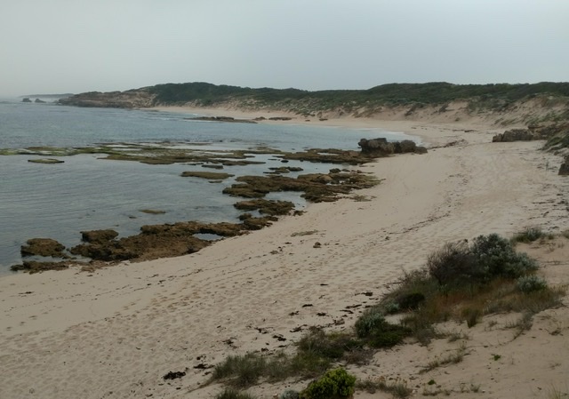


My sixth and final day was muggy with a bit of sun. After the long bus ride to Sorrento I returned to the back beach and followed the coastline to London Bridge (pic). This included walking the length of Portsea Back Beach, a lovely straight stretch of golden sand.

From London Bridge onwards I was in Point Nepean National Park and my goal was to go to the tip of the peninsula, a further 5 kms. There are plenty of tracks here but most are closed to the public because it’s army land. There are bunkers all over the place. I was able to make a detour off the road, past a couple of rifle ranges, to go up Monash Tower on Cheviot Hill for a good view towards the other side of the heads: Point Lonsdale lighthouse was very prominent as well as the beaches at Queenscliff. I then crossed to the other side of the peninsula (not a long way at all) for a view back along a sandy beach towards Portsea and my first view of the tip of the peninsula, where there are more bunkers. The track came back to the road for the last kilometre to the tip and it is amazing how narrow this strip of land is down here, but still quite high so there are great views on both sides, of the bay and the ocean. I watched the Sorrento to Queenscliff ferry. Unfortunately the road was blocked off for the final 800 metres (a covid reason which didn’t make sense to me) so I could see the tip but not quite get there.

I walked the road back to the park entrance, calling in at the beach where Harold Holt drowned and seeing a cute echidna on a side trail (guess what, pic above), and continued the extra kilometre into Portsea where I had a 3pm lunch at the pub. With 18 kms today I had walked 127 kms in total. I was fairly tired, pleased that my foot had survived the exercise, although it was still sore from yesterday’s sand dune, and I realised this is the longest walk I’ve done since my Great North Walk.